
Harrisburg is the capital city of the Commonwealth of Pennsylvania, United States, and the seat of Dauphin County. With a population of 50,135 as of 2021, Harrisburg is the ninth-largest city and 15th-largest municipality in Pennsylvania. Harrisburg is situated on the east bank of the Susquehanna River. It is the larger principal city of the Harrisburg–Carlisle metropolitan statistical area, also known as the Susquehanna Valley, which had a population of 591,712 as of 2020, making it the fourth-most populous metropolitan area in Pennsylvania after the Philadelphia, Pittsburgh, and Lehigh Valley metropolitan areas.
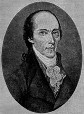
William Maclay was a politician from Pennsylvania during the eighteenth century. Maclay, along with Robert Morris, was a member of Pennsylvania's first two-member delegation to the United States Senate. He assisted John Harris, Sr. with the planning the layout of Harrisburg, Pennsylvania in 1785, where Maclay Street is named for him. Following his tenure in the Senate, he served in the Pennsylvania House of Representatives on two occasions, as a county judge, and as a presidential elector. He is known for his journal providing historical information on the 1st United States Congress.
The Greater Richmond, Virginia area has many neighborhoods and districts.

Neighborhoods in Washington, D.C., United States are distinguished by their history, culture, architecture, demographics, and geography. The names of 131 neighborhoods are unofficially defined by the D.C. Office of Planning. Neighborhoods can be defined by the boundaries of wards, historic districts, Advisory Neighborhood Commissions, civic associations, and business improvement districts (BIDs); these boundaries will overlap. The eight wards each elect a member to the Council of the District of Columbia and are redistricted every ten years.

Uptown is a section of Harrisburg, Pennsylvania located North of the Midtown and Downtown neighborhoods.

Downtown Harrisburg is the central core neighborhood, business and government center which surrounds the focal point of Market Square, and serves as the regional center for the greater metropolitan area of Harrisburg, Pennsylvania, United States.
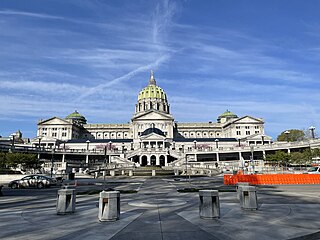
The Pennsylvania State Capitol is the seat of government for the U.S. state of Pennsylvania located in downtown Harrisburg which was designed by architect Joseph Miller Huston in 1902 and completed in 1906 in a Beaux-Arts style with decorative Renaissance themes throughout. The capitol houses the legislative chambers for the Pennsylvania General Assembly, made up of the House of Representatives and the Senate, and the Harrisburg chambers for the Supreme and Superior Courts of Pennsylvania, as well as the offices of the Governor and the Lieutenant Governor. It is also the main building of the Pennsylvania State Capitol Complex.

Camp Curtin is a historic neighborhood in Harrisburg, Pennsylvania's northern end, located in Uptown and named for the American Civil War camp of the same name. It is bordered currently by landmarks of Fifth Street to the west, the railroad tracks next to the Pennsylvania Farm Show Complex to the east, Maclay Street to the south, and Reels Lane to the North.
Allison Hill is a neighborhood in Harrisburg, Pennsylvania, in the United States. It is located directly east of downtown Harrisburg on a bluff overlooking the older original borough along the Susquehanna River. The Hill comprises some sub-neighborhoods, such as Hillside Village; others have nicknames such as "The Ville" and the "Third Ward". Primarily, it can be separated into three smaller neighborhoods: North Allison Hill, Central Allison Hill, and South Allison Hill. It was named after William Allison, an early Harrisburg landowner who owned farms on the bluff outside of the then-Borough. First referred to as "Allison's Farm" or "Allison's Hill Farm", it finally became shortened to "Allison Hill" as the City expanded.

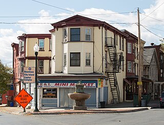
Midtown is a neighborhood in Harrisburg, Pennsylvania. Its zip code is 17102. The Midtown neighborhood is delineated by Forster Street to the south, Maclay Street to the north, 7th Street to the east, and the Susquehanna River to the west. Former Harrisburg Mayor William K. Verbeke is the namesake for Verbeke Street and first bought and developed the area. Midtown is home to the Pennsylvania Governor's Residence and the Broad Street Market, the oldest continually operated street market in the country.

The Capitol District is a neighborhood adjacent to the state capitol in Harrisburg, Pennsylvania. It is delineated by Forster St. to the North, Walnut St. to the South, 3rd St. to the East, and the Susquehanna River to the west. This neighborhood borders the large Pennsylvania State Capitol Complex and has easy access to the Downtown Harrisburg. The Capital District is home to Saint Patrick's Cathedral, St. Stephen's Episcopal Cathedral, State Museum of Pennsylvania, the historic Harrisburg Area YMCA building, many beautiful houses, and several small bistros.

The Old Midtown Historic District is a historic district that is located in the Midtown neighborhood of Harrisburg, Pennsylvania. It stretches from Forster to Verbeke and from Front to Third street, and represents the first urbanized neighborhood in the city of Harrisburg.

Washington, D.C., is administratively divided into four geographical quadrants of unequal size, each delineated by their ordinal directions from the medallion located in the Crypt under the Rotunda of the Capitol. Street and number addressing, centered on the Capitol, radiates out into each of the quadrants, producing a number of intersections of identically named cross-streets in each quadrant. Originally, the District of Columbia was a near-perfect square. However, even then the Capitol was never located at the geographic center of the territory. As a result, the quadrants are of greatly varying size. Northwest is quite large, encompassing over a third of the city's geographical area, while Southwest is little more than a neighborhood and military base.

Hardscrabble was a small settlement of mostly frame structures in Midtown Harrisburg, Pennsylvania from late 18th century to 1924, so named because of its reputation as a rough place.

Montrose Park is a populated place and unincorporated community that is located in Susquehanna Township, Dauphin County, Pennsylvania, United States. It is part of the Harrisburg-Carlisle, Metropolitan Statistical Area.
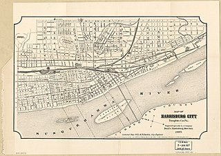
This is a timeline of the major events in the history of Harrisburg, Pennsylvania and vicinity.

Camp Curtin Memorial Methodist Episcopal Church, also known as Curtin Heights Church and Camp Curtin Memorial-Mitchell United Methodist Church, is a historic Methodist Episcopal church located in Harrisburg, Dauphin County, Pennsylvania.
Little Rock, Arkansas is home to numerous neighborhoods. See List of Little Rock Neighborhoods for an exhaustive list.

The Pennsylvania State Capitol Complex is a large complex of state government buildings in Harrisburg, Pennsylvania. Set on more than 50 acres (20 ha) of downtown Harrisburg, it includes the Pennsylvania State Capitol and a landscaped park environment with monuments, memorials, and other government buildings. It is bounded on the north by Forster Street, the east by North 7th Street, the south by Walnut Street, and the west by North 3rd Street. Most of this area is a National Historic Landmark District, recognized in 2013 as a fully realized example of the City Beautiful movement landscape and planning design of Arnold Brunner.

South Allison Hill is a neighborhood within the Allison Hill section of Harrisburg, Pennsylvania. It is bordered by Cameron Street to the west, South 18th Street to the east, Market Street to the north, and Paxton Street to the south. South Allison Hill is home to over 6,000 residents, about 2,700 building parcels as well as dozens of nonprofit organizations, faith-based institutions, and a large number of local businesses reflecting the diverse population. Considered by Harrisburg Magazine a "haven for multicultural provisions," South Allison Hill's grocery stores each have a uniqueness "that confirms the ethnic diversity for which South Allison Hill is known."
