Harrisburg is the capital city of the Commonwealth of Pennsylvania, United States, and the seat of Dauphin County. With a population of 50,135 as of 2021, Harrisburg is the ninth-most populous city in Pennsylvania.

Urban renewal is a program of land redevelopment often used to address urban decay in cities. Urban renewal involves the clearing out of blighted areas in inner cities to clear out slums and create opportunities for higher class housing, businesses, and other developments. In the United States the term technically refers only to a federal program in the middle-to-late 20th Century, but colloquially is sometimes used to refer to any large-scale change in urban development.

The City Beautiful movement was a reform philosophy of North American architecture and urban planning that flourished during the 1890s and 1900s with the intent of introducing beautification and monumental grandeur in cities. It was a part of the progressive social reform movement in North America under the leadership of the upper-middle class, which was concerned with poor living conditions in all major cities. The movement, which was originally associated mainly with Chicago, Cleveland, Detroit, Kansas City and Washington, D.C., promoted beauty not only for its own sake, but also to create moral and civic virtue among urban populations.

Congress Heights is a residential neighborhood in Southeast Washington, D.C., in the United States. The irregularly shaped neighborhood is bounded by the St. Elizabeths Hospital campus, Lebaum Street SE, 4th Street SE, and Newcomb Street SE on the northeast; Shepard Parkway and South Capitol Street on the west; Atlantic Street SE and 1st Street SE on the south; Oxon Run Parkway on the southeast; and Wheeler Street SE and Alabama Avenue SE on the east. Commercial development is heavy along Martin Luther King, Jr. Avenue and Malcolm X Avenue.

Whittier is a neighborhood within the Powderhorn community in the U.S. city of Minneapolis, Minnesota, bounded by Franklin Avenue on the north, Interstate 35W on the east, Lake Street on the south, and Lyndale Avenue on the west. It is known for its many diverse restaurants, coffee shops and Asian markets, especially along Nicollet Avenue. The neighborhood is home to the Minneapolis Institute of Art, the Minneapolis College of Art and Design, and the Children's Theatre Company.
City Heights is a dense urban community in central San Diego, California, known for its ethnic diversity. The area was previously known as East San Diego. City Heights is located south of Mission Valley and northeast of Balboa Park.

Garfield is a neighborhood in the East End of the City of Pittsburgh, Pennsylvania, United States. Garfield is bordered on the South by Bloomfield and Friendship, on the West by the Allegheny Cemetery, on the North by Stanton Heights, and on the East by East Liberty. Like many parts of Pittsburgh, Garfield is a fairly steep neighborhood, with north-south residential streets running at about a 20% incline from Penn Avenue at the bottom to Mossfield Street at the top. Garfield is divided into “the valley” and “the hilltop.”
HOPE VI is a program of the United States Department of Housing and Urban Development. It is intended to revitalize the most distressed public housing projects in the United States into mixed-income developments. Its philosophy is largely based on New Urbanism and the concept of defensible space.
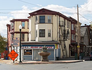
Allison Hill is a neighborhood in Harrisburg, Pennsylvania, in the United States. It is located directly east of downtown Harrisburg on a bluff overlooking the older original borough along the Susquehanna River. The Hill comprises some sub-neighborhoods, such as Hillside Village; others have nicknames such as "The Ville" and the "Third Ward". Primarily, it can be separated into three smaller neighborhoods: North Allison Hill, Central Allison Hill, and South Allison Hill. It was named after William Allison, an early Harrisburg landowner who owned farms on the bluff outside of the then-Borough. First referred to as "Allison's Farm" or "Allison's Hill Farm", it finally became shortened to "Allison Hill" as the City expanded.

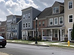
Midtown is a neighborhood in Harrisburg, Pennsylvania. Its zip code is 17102. The Midtown neighborhood is delineated by Forster Street to the south, Maclay Street to the north, 7th Street to the east, and the Susquehanna River to the west. Former Harrisburg Mayor William K. Verbeke is the namesake for Verbeke Street and first bought and developed the area. Midtown is home to the Pennsylvania Governor's Residence and the Broad Street Market, the oldest continually operated street market in the country.
Independence Heights is a community in Houston, Texas, bordered by 40th Street east of N. Main and 40th Street west of N. Main to the north, Yale Street to the west, the 610 Loop to the south, and Airline Drive to the east. The Super Neighborhood boundary created by the City of Houston is bordered by Tidwell to the north, Shepherd Drive to the west, the 610 Loop to the south, and Interstate 45 to the east.

The neighborhoods of Milwaukee include a number of areas in southeastern Wisconsin within the state's largest city at nearly 600,000 residents.

Navy Yard is a neighborhood of Washington, D.C., located in Southeast D.C. Navy Yard, situated along the Anacostia Riverfront south of Capitol Hill, takes its name from Washington Navy Yard, the administrative seat of the U.S. Navy. Historically an industrial area, today Navy Yard is a popular entertainment district, home to Nationals Park, a notable nightlife scene, and numerous waterfront esplanades.

Marshall Heights is a residential neighborhood in Southeast Washington, D.C. It is bounded by East Capitol Street, Central Avenue SE, Southern Avenue, Fitch Street SE, and Benning Road SE. It was an undeveloped rural area occupied by extensive African American shanty towns, but the neighborhood received nationwide attention after a visit by First Lady Eleanor Roosevelt in 1934, which led to extensive infrastructure improvements and development for the first time. In the 1950s, Marshall Heights residents defeated national legislation designed to raze and redevelop the neighborhood. Queen Elizabeth II of the United Kingdom visited the area in 1991, at a time when Marshall Heights was in the throes of a violent crack cocaine epidemic. Limited redevelopment has occurred in the neighborhood, which was the site of two notorious child murders in 1973.

Middle East is a neighborhood in the heart of East Baltimore, Maryland.

Barclay is a neighborhood in the center of Baltimore City. Its boundaries, as defined by the City Planning Office, are marked by North Avenue, Greenmount Avenue, Saint Paul and 25th Streets. The neighborhood lies north of Greenmount West, south of Charles Village, west of East Baltimore Midway, and east of Charles North and Old Goucher. The boundary between the Northern and Eastern police districts runs through the community, cutting it roughly in half.
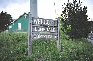
Lonsdale is a neighborhood in Knoxville, Tennessee, United States, located northwest of the city's downtown area. Established in the late-19th century as a land development project, Lonsdale incorporated as a separate city in 1907, and was annexed by Knoxville in 1917. After a period of decline in the latter half of the 20th century, Lonsdale has recently undergone several major revitalization efforts.

Peoplestown is a neighborhood of Atlanta just south of Center Parc Stadium and Downtown Atlanta.
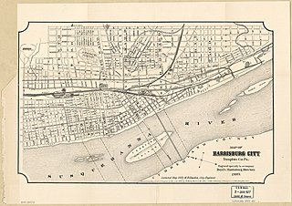
This is a timeline of the major events in the history of Harrisburg, Pennsylvania and vicinity.