
Harrisburg is the capital city of the Commonwealth of Pennsylvania, United States, and the seat of Dauphin County. With a population of 50,135 as of 2021, Harrisburg is the ninth-largest city and 15th-largest municipality in Pennsylvania. Harrisburg is situated on the east bank of the Susquehanna River. It is the larger principal city of the Harrisburg–Carlisle metropolitan statistical area, also known as the Susquehanna Valley, which had a population of 591,712 as of 2020, making it the fourth-most populous metropolitan area in Pennsylvania after the Philadelphia, Pittsburgh, and Lehigh Valley metropolitan areas.

Wilkes-Barre is a city in and the county seat of Luzerne County, Pennsylvania, United States. Located at the center of the Wyoming Valley in Northeastern Pennsylvania, it had a population of 44,328 in the 2020 census. It is the second-largest city, after Scranton, in the Scranton–Wilkes-Barre–Hazleton, PA Metropolitan Statistical Area, which had a population of 567,559 as of the 2020 census, making it the fifth-largest metropolitan area in Pennsylvania.

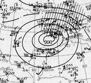
Hurricane Agnes in 1972 was the costliest hurricane to hit the United States at the time, causing an estimated $2.1 billion in damage. The hurricane's death toll was 128. The effects of Agnes were widespread, from the Caribbean to Canada, with much of the east coast of the United States affected. Damage was heaviest in Pennsylvania, where Agnes was the state's wettest tropical cyclone. Due to the significant effects, the name Agnes was retired in the spring of 1973.

Buffalo Bayou is a slow-moving body of water which flows through Houston in Harris County, Texas. Formed 18,000 years ago, it has its source in the prairie surrounding Katy, Fort Bend County, and flows approximately 53 miles (85 km) east through the Houston Ship Channel into Galveston Bay and the Gulf of Mexico. In addition to drainage water impounded and released by the Addicks and Barker reservoirs, the bayou is fed by natural springs, surface runoff, and several significant tributary bayous, including White Oak Bayou, Greens Bayou, and Brays Bayou. Additionally, Buffalo Bayou is considered a tidal river downstream of a point 440 yards (400 m) west of the Shepherd Drive bridge in west-central Houston.

The Lower Ninth Ward is a neighborhood in the city of New Orleans, Louisiana. As the name implies, it is part of the 9th Ward of New Orleans. The Lower Ninth Ward is often thought of as the entire area within New Orleans downriver of the Industrial Canal; however, the City Planning Commission divides this area into the Lower Ninth Ward and Holy Cross neighborhoods.

The Northern Central Railway (NCRY) was a Class I Railroad connecting Baltimore, Maryland with Sunbury, Pennsylvania, along the Susquehanna River. Completed in 1858, the line came under the control of the Pennsylvania Railroad (PRR) in 1861, when the PRR acquired a controlling interest in the Northern Central's stock to compete with the rival Baltimore and Ohio Railroad (B&O). For eleven decades the Northern Central operated as a subsidiary of the PRR until much of its Maryland trackage was washed out by Hurricane Agnes in 1972, after which most of its operations ceased as the Penn Central declined to repair sections. It is now a fallen flag railway, having come under the control of the later Penn Central, Conrail, and then broken apart and disestablished. The northern part in Pennsylvania is now the York County Heritage Rail Trail which connects to a similar hike/bike trail in Northern Maryland down to Baltimore, named the Torrey C. Brown Rail Trail. Trackage around Baltimore remains in rail service as well as most of the trackage in Pennsylvania which is operated by Norfolk Southern and the southernmost section in Pennsylvania is operated by the Northern Central heritage railway.

Uptown is a section of Harrisburg, Pennsylvania located North of the Midtown and Downtown neighborhoods.

Downtown Harrisburg is the central core neighborhood, business and government center which surrounds the focal point of Market Square, and serves as the regional center for the greater metropolitan area of Harrisburg, Pennsylvania, United States.

The Walnut Street Bridge also known as The People's Bridge, is a truss bridge that spanned the Susquehanna River in Harrisburg, Pennsylvania until 1996. Built by the Phoenix Bridge Company in 1890, it is the oldest remaining bridge connecting Harrisburg's downtown and Riverfront Park with City Island. Since flooding in 1996 collapsed sections of the western span, it no longer connects to the West Shore. The bridge was added to the National Register of Historic Places in 1971. A 2014 Cross-River Connections Study notes that the bridge currently serves as an "important bicycle and pedestrian link between City Island and downtown Harrisburg, connecting the city and the Capital Area Greenbelt to special events on City Island."

Midtown is a neighborhood in Harrisburg, Pennsylvania. Its zip code is 17102. The Midtown neighborhood is delineated by Forster Street to the south, Maclay Street to the north, 7th Street to the east, and the Susquehanna River to the west. Former Harrisburg Mayor William K. Verbeke is the namesake for Verbeke Street and first bought and developed the area. Midtown is home to the Pennsylvania Governor's Residence and the Broad Street Market, the oldest continually operated street market in the country.
The Tampa Bay hurricane of 1921 was a major hurricane which affected Central Florida and the western Caribbean Sea in late October 1921. It was the major storm that stuck the continental United States latest in the calendar year until Hurricane Zeta in 2020. The eleventh tropical cyclone, sixth tropical storm, and fifth hurricane of the season, the storm developed from a trough in the southwestern Caribbean Sea on October 20. Initially a tropical storm, the system moved northwestward and intensified into a hurricane on October 22 and a major hurricane by October 23. Later that day, the hurricane peaked as a Category 4 on the modern day Saffir–Simpson scale with maximum sustained winds of 140 mph (230 km/h). After entering the Gulf of Mexico, the hurricane gradually curved northeastward and weakened to a Category 3 before making landfall near Tarpon Springs, Florida, late on October 25. It was the first major hurricane to make landfall in the Tampa Bay area since the hurricane of 1848 and the last to date.

The Mid-Atlantic United States flood of 2006 was a significant flood that affected much of the Mid-Atlantic region of the eastern United States. The flooding was very widespread, affecting numerous rivers, lakes and communities from upstate New York to North Carolina. It was widely considered to be the worst flooding in the region since Hurricane David in 1979. It was also one of the worst floodings in the United States since Hurricane Katrina in August 2005. At least 16 deaths were related to the flooding.

The history of Harrisburg, the state capital of the Commonwealth of Pennsylvania, United States, has played a key role in the development of the nation's industrial history from its origins as a trading outpost to the present. Harrisburg has played a critical role in American history during the Westward Migration, the American Civil War, and the Industrial Revolution. For part of the 19th century, the building of the Pennsylvania Canal and later the Pennsylvania Railroad allowed Harrisburg to become one of the most industrialized cities in the Northeast.

The Pennsylvania Governor's Residence is the official residence of the governor of Pennsylvania, in the Uptown neighborhood of Harrisburg, Pennsylvania. The neo-Georgian residence was built from 1966 to 1968 and designed by George M. Ewing, heading an architectural firm in Philadelphia. The mansion was previously only used for official functions and meetings, because then-Governor Tom Wolf commuted from his private residence in nearby Mount Wolf.

Tropical Storm Lee was the thirteenth named storm and fifteenth system overall of the 2011 Atlantic hurricane season, developing from a broad tropical disturbance over the gulf on September 1. It was designated as Tropical Storm Lee the next day. Prior to 2020, when Marco formed on August 22, Lee was tied with 2005's Maria as the earliest-forming 13th Atlantic tropical storm. The system was rather large, and due to drifting, Lee brought flash flooding to the Gulf Coast. Flooding associated with the rains caused significant property damage in the areas, with drowning deaths reported in both Mississippi and Georgia. Elsewhere, the storm helped spread wildfires that destroyed homes and killed two people in Texas, and a traffic accident in Alabama resulted in one death. Rough surf offshore drowned one person in each of these states. After becoming extratropical, Lee caused historic flooding in Pennsylvania, New York, and Canada, mainly Quebec and Ontario.
This is a timeline of the major events in the history of Harrisburg, Pennsylvania and vicinity.

Kinney Run, also known as Kinney's Run, is a tributary of the Susquehanna River in Scott Township and Bloomsburg, Columbia County, Pennsylvania, in the United States. It is approximately 3.1 miles (5.0 km) long. Some of the first settlers to the Kinney Run area arrived in 1769. There are a number of wetlands and one bog, which is called the Espy Bog, in the stream's watershed.

The 1896 Cedar Keys hurricane was a powerful and destructive tropical cyclone that devastated much of the East Coast of the United States, starting with Florida's Cedar Keys, near the end of September 1896. The storm's rapid movement allowed it to maintain much of its intensity after landfall and cause significant damage over a broad area; as a result, it became one of the costliest United States hurricanes at the time. The fourth tropical cyclone of the 1896 Atlantic hurricane season, it formed by September 22, likely from a tropical wave, before crossing the Caribbean Sea just south of the Greater Antilles. It entered the Gulf of Mexico as the equivalent of a major hurricane on the Saffir–Simpson scale, and struck the Cedar Keys—an offshore island chain that includes the island and city of Cedar Key—early on the morning of September 29 with winds of 125 mph (205 km/h). The area was inundated by a devastating 10.5 ft (3.2 m) storm surge that undermined buildings, washed out the connecting railroad to the mainland, and submerged the smaller, outlying islands, where 31 people were killed. Strong winds also destroyed many of the red cedar trees that played an important role in the economy of the region.

