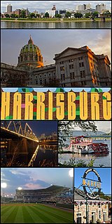
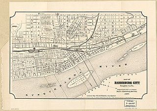
Harrisburg is the capital city of the Commonwealth of Pennsylvania, and the county seat of Dauphin County. With a population of 50,099 as of the 2020 census, Harrisburg is the 15th largest city in Pennsylvania.

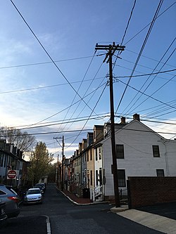
Middletown is a borough in Dauphin County, Pennsylvania, United States, on the Susquehanna River, 10 miles (16 km) southeast of Harrisburg. As of the 2020 census it had a population of 9,550. It is part of the Harrisburg–Carlisle Metropolitan Statistical Area.
Shippensburg is a borough in Cumberland and Franklin counties in the U.S. Commonwealth of Pennsylvania. Settled in 1730, Shippensburg lies in the Cumberland Valley, 41 miles (66 km) southwest of Harrisburg, and is part of the Harrisburg–Carlisle Metropolitan Statistical Area. The population was 5,492 at the 2010 census. Of this, 4,416 were in Cumberland County, and 1,076 were in Franklin County.

Near Northeast is a Syracuse, New York neighborhood, located northeast of the city's downtown. It corresponds to Onondaga County Census Tract 15, 16, 23, and 24.

Cumberland County is a county located in the U.S. state of Pennsylvania. As of the 2020 census, the population was 259,469. Its county seat is Carlisle.
East Harrisburg is a district of neighborhoods in the eastern end of Harrisburg, Pennsylvania. Its southern border is formed by Interstate 83; eastern border is Paxtang along 29th Street; northern border is Market Street and the borough of Penbrook; western border is the Allison Hill neighborhood along 21st Street and including Bellevue Park. The historic former private Bishop McDevitt High School and current public John Harris High School are located in East Harrisburg.
Camp Curtin is a historic neighborhood in Harrisburg, Pennsylvania's northern end, located in Uptown and named for the American Civil War camp of the same name. It is bordered currently by landmarks of Fifth Street to the west, the railroad tracks next to the Pennsylvania Farm Show Complex to the east, Maclay Street to the south, and Reels Lane to the North.
Allison Hill is a neighborhood in Harrisburg, Pennsylvania, in the United States. It is located directly east of downtown Harrisburg on a bluff overlooking the older original borough along the Susquehanna River. The Hill comprises some sub-neighborhoods, such as Hillside Village; others have nicknames such as "The Ville" and the "Third Ward". Primarily, it can be separated into three smaller neighborhoods: North Allison Hill, Central Allison Hill, and South Allison Hill. It was named after William Allison, an early Harrisburg landowner who owned farms on the bluff outside of the then-Borough. First referred to as "Allison's Farm" or "Allison's Hill Farm", it finally became shortened to "Allison Hill" as the City expanded.

Midtown is a neighborhood in Harrisburg, Pennsylvania. Its zip code is 17102. The Midtown neighborhood is delineated by Forster Street to the south, Maclay Street to the north, 7th Street to the east, and the Susquehanna River to the west. Former Harrisburg Mayor William K. Verbeke is the namesake for Verbeke Street and first bought and developed the area. Midtown is home to the Pennsylvania Governor's Mansion and the Broad Street Market, the oldest continually operated street market in the country.

WTKT is an AM radio station in Harrisburg, Pennsylvania. The station broadcasts at 1460 kHz with 5,000 watts power daytime non-directional and 4,200 watts night time power from a three tower antenna array in Summerdale, Pennsylvania. WTKT is the AM flagship station for Hershey Bears AHL hockey.
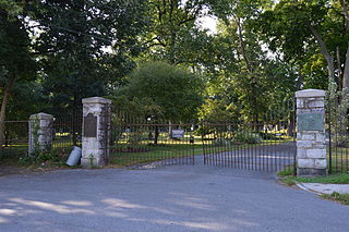
Harrisburg Cemetery, sometimes referred to as Mount Kalmia Cemetery, is a prominent rural cemetery and national historic district in Harrisburg, Pennsylvania, located at 13th and Liberty streets in the Allison Hill/East Harrisburg neighborhoods of the city. It was officially founded in 1845, although interments took place for many years before. The cemetery is also the burial ground for American Revolutionary War soldiers. The caretaker's cottage was built in 1850. It was designed by famed 19th Century architect, Andrew Jackson Downing, in the Gothic Revival style.

Uptown Oakland is a neighborhood in Oakland, California, located in the northern end of Downtown. It is located roughly between West Grand Avenue to the north, Interstate 980 to the west, City Center and 14th Street to the south, and Broadway to the east. The neighborhood has become an important entertainment district in recent years.

Washington Square is one of the 26 officially recognized neighborhoods of Syracuse, New York.

This is a list of the National Register of Historic Places listings in Detroit, Michigan.

Wissahickon is a neighborhood in the section of Lower Northwest Philadelphia in the state of Pennsylvania. Wissahickon is located adjacent to the neighborhoods of Roxborough and Manayunk, and it is bounded by the Wissahickon Valley Park, Ridge Avenue, Hermit Street, and Henry Avenue. The name of the neighborhood comes from the Lenni Lenape word wisameckham, for "catfish creek", a reference to the fish that were once plentiful in the Wissahickon Creek.

Harrisburg's Market Square is located in Downtown Harrisburg at the intersection of 2nd and Market Streets. The square was created in 1785. Since then, it has traditionally been the navigational center of the city, and since the 1980s has undergone a revival with several new commercial, residential and retail spaces either planned or built. Market Square serves as a hub for Capital Area Transit (CAT) buses. It is one block from Riverfront Park and the Market Street Bridge, which crosses over the Susquehanna River.
This is a timeline of the major events in the history of Harrisburg, Pennsylvania and vicinity.
Briggsdale is a neighborhood of Franklin County in the city of Columbus, Ohio. The neighborhood is on the west/southwest side of the city within the Hilltop area. The area was first settled and founded by the family of Joseph M. Briggs, after whom the neighborhood was named. Joseph Briggs was an active figure in the early years of the township and county operations. The Briggsdale Methodist church was founded with his help, and it now exists as the New Horizons Methodist Church. The present day Briggsdale neighborhood is located near the historical Green Lawn Cemetery to the north as well as Briggs High School to the west.
Academy Manor is a historical suburban subdivision of the Riverside neighborhood within the Uptown section of Harrisburg, Pennsylvania. The neighborhood extends north from Front and Division Street up to the location of former Harrisburg Academy, west to Parkview Lane, and south back to Division St. It was established in the early 20th century with specific plans in terms of lot sizes, setbacks, and the kinds of buildings permitted.