Harrisburg is the capital city of the Commonwealth of Pennsylvania, United States, and the seat of Dauphin County. With a population of 50,135 as of 2021, Harrisburg is the ninth-most populous city in Pennsylvania.
Dauphin County is a county in the Commonwealth of Pennsylvania. As of the 2020 census, the population was 286,401. The county seat is Harrisburg, Pennsylvania's state capital and ninth-most populous city. The county was created on March 4, 1785, from part of Lancaster County and was named after Louis Joseph, Dauphin of France, the first son of King Louis XVI. The county is part of the South Central Pennsylvania region of the state.

The City Beautiful movement was a reform philosophy of North American architecture and urban planning that flourished during the 1890s and 1900s with the intent of introducing beautification and monumental grandeur in cities. It was a part of the progressive social reform movement in North America under the leadership of the upper-middle class, which was concerned with poor living conditions in all major cities. The movement, which was originally associated mainly with Chicago, Cleveland, Detroit, Kansas City and Washington, D.C., promoted beauty not only for its own sake, but also to create moral and civic virtue among urban populations.

Northwest is the northwestern quadrant of Washington, D.C., the capital of the United States, and is located north of the National Mall and west of North Capitol Street. It is the largest of the four quadrants of the city, and it includes the central business district, the Federal Triangle, and the museums along the northern side of the National Mall, as well as many of the District's historic neighborhoods.
The Hill most frequently refers to Capitol Hill, Washington, D.C., and entities named after it, including:

The Cathedral of Saint Patrick is a cathedral of the Catholic Church in downtown Harrisburg, Pennsylvania, United States. It is the mother church of the Diocese of Harrisburg and is the seat of its bishop. It is a contributing property in the Harrisburg Historic District on the National Register of Historic Places.

Massachusetts Avenue is a major diagonal transverse road in Washington, D.C., and the Massachusetts Avenue Historic District is a historic district that includes part of it.

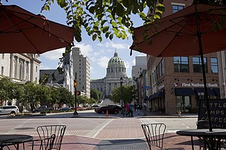
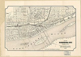
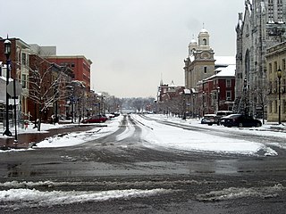
Downtown Harrisburg is the central core neighborhood, business and government center which surrounds the focal point of Market Square, and serves as the regional center for the greater metropolitan area of Harrisburg, Pennsylvania, United States.
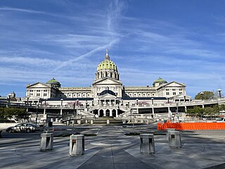
The Pennsylvania State Capitol is the seat of government for the U.S. state of Pennsylvania located in downtown Harrisburg which was designed by architect Joseph Miller Huston in 1902 and completed in 1906 in a Beaux-Arts style with decorative Renaissance themes throughout. The capitol houses the legislative chambers for the Pennsylvania General Assembly, made up of the House of Representatives and the Senate, and the Harrisburg chambers for the Supreme and Superior Courts of Pennsylvania, as well as the offices of the Governor and the Lieutenant Governor. It is also the main building of the Pennsylvania State Capitol Complex.
Allison Hill is a neighborhood in Harrisburg, Pennsylvania, in the United States. It is located directly east of downtown Harrisburg on a bluff overlooking the older original borough along the Susquehanna River. The Hill comprises some sub-neighborhoods, such as Hillside Village; others have nicknames such as "The Ville" and the "Third Ward". Primarily, it can be separated into three smaller neighborhoods: North Allison Hill, Central Allison Hill, and South Allison Hill. It was named after William Allison, an early Harrisburg landowner who owned farms on the bluff outside of the then-Borough. First referred to as "Allison's Farm" or "Allison's Hill Farm", it finally became shortened to "Allison Hill" as the City expanded.

Midtown is a neighborhood in Harrisburg, Pennsylvania. Its zip code is 17102. The Midtown neighborhood is delineated by Forster Street to the south, Maclay Street to the north, 7th Street to the east, and the Susquehanna River to the west. Former Harrisburg Mayor William K. Verbeke is the namesake for Verbeke Street and first bought and developed the area. Midtown is home to the Pennsylvania Governor's Residence and the Broad Street Market, the oldest continually operated street market in the country.
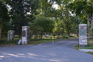
Harrisburg Cemetery, sometimes referred to as Mount Kalmia Cemetery, is a prominent rural cemetery and national historic district in Harrisburg, Pennsylvania, located at 13th and Liberty streets in the Allison Hill/East Harrisburg neighborhoods of the city. It was founded in 1845, though interments took place for many years before.

Capitol Heights is a community of over 300 townhouse and single-family duplexes in the Midtown neighborhood of Harrisburg, Pennsylvania. Most of the new homes are located east of Third between Kelker and Reily and along Fulton, 4th and 5th street. The neighborhood is known for its generic suburban-style architecture fitted to the existing street grid. The area was previously referred to informally as "Lottsville" due to its many abandoned and vacant lots, so the City and private developers worked together in the 2000s for large-scale redevelopment as it was a targeted area for demolition and urban renewal. As revitalization was completed in the early 2010s, the intense level of change and influx of capital resulted in much lower vacancy rates and higher land values. Another phased project in 2021 was introduced to develop over 100 new parcels and add a community center.
This is a timeline of the major events in the history of Harrisburg, Pennsylvania and vicinity.
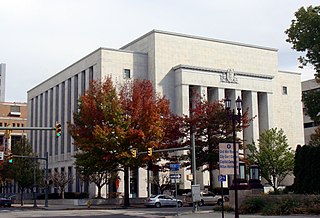
The Harrisburg Historic District is a national historic district which is located in Harrisburg, Dauphin County, Pennsylvania.

Maris Harvey Taylor, also known as M. Harvey Taylor or Harvey Taylor, was an American politician from Pennsylvania who served as a Republican member of the Pennsylvania Senate for the 15th district from 1941 to 1964 including as President pro tempore from 1945 to 1964. He was a political boss who held multiple political positions in Dauphin County and statewide.

The Pennsylvania State Capitol Complex is a large complex of state government buildings in Harrisburg, Pennsylvania. Set on more than 50 acres (20 ha) of downtown Harrisburg, it includes the Pennsylvania State Capitol and a landscaped park environment with monuments, memorials, and other government buildings. It is bounded on the north by Forster Street, the east by North 7th Street, the south by Walnut Street, and the west by North 3rd Street. Most of this area is a National Historic Landmark District, recognized in 2013 as a fully realized example of the City Beautiful movement landscape and planning design of Arnold Brunner.

South Allison Hill is a neighborhood within the Allison Hill section of Harrisburg, Pennsylvania. It is bordered by Cameron Street to the west, South 18th Street to the east, Market Street to the north, and Paxton Street to the south. South Allison Hill is home to over 6,000 residents, about 2,700 building parcels as well as dozens of nonprofit organizations, faith-based institutions, and a large number of local businesses reflecting the diverse population. Considered by Harrisburg Magazine a "haven for multicultural provisions," South Allison Hill's grocery stores each have a uniqueness "that confirms the ethnic diversity for which South Allison Hill is known."

Academy Manor is a historical suburban subdivision of the Riverside neighborhood within the Uptown section of Harrisburg, Pennsylvania. The neighborhood extends north from Front and Division Street up to the location of former Harrisburg Academy, west to Parkview Lane, and south back to Division St. It was established in the early 20th century with specific plans in terms of lot sizes, setbacks, and the kinds of buildings permitted.