Uptown | |
|---|---|
 Housing stock along 6th Street Uptown | |
 | |
| Country | |
| State | Pennsylvania |
| County | Dauphin County |
| City | Harrisburg |
| Area code(s) | 717 and 223 |
Uptown is a section of Harrisburg, Pennsylvania located North of the Midtown and Downtown neighborhoods.
Uptown | |
|---|---|
| Housing stock along 6th Street Uptown | |
| | |
| Country | |
| State | Pennsylvania |
| County | Dauphin County |
| City | Harrisburg |
| Area code(s) | 717 and 223 |
Uptown is a section of Harrisburg, Pennsylvania located North of the Midtown and Downtown neighborhoods.
Bordered by the Susquehanna River to the West, Maclay Street to the South, North 7th Street to the East and Susquehanna Township to the North, the neighborhood is home to many ornate mansions along Front Street and Italian Lake, as well as moderately sized homes exemplifying character of early 20th-century architecture. After being devastated in 1972 by the flooding of Hurricane Agnes, the neighborhood slipped into a moderate decline. Since then, new homeowners have made improvements, causing property values to increase dramatically through the beginning of the 21st century. With the Susquehanna River's Riverfront Park and Capital Area Greenbelt within walking distance—as well as Italian Lake—Uptown Harrisburg is an example of relaxed urban living. Much of Uptown's development (post-automobile) lends itself to having longer blocks, rear alleys with detached garages, and shopping plazas/large surface parking lots. [1]
Uptown contains three Historic Places on the National Register: Camp Curtin Fire Station, Camp Curtin Memorial Methodist Episcopal Church, and Polyclinic Medical Center.


Harrisburg is the capital city of the Commonwealth of Pennsylvania, United States, and the seat of Dauphin County. With a population of 50,135 as of 2021, Harrisburg is the ninth-largest city and 15th-largest municipality in Pennsylvania. Harrisburg is situated on the east bank of the Susquehanna River. It is the larger principal city of the Harrisburg–Carlisle metropolitan statistical area, also known as the Susquehanna Valley, which had a population of 591,712 as of 2020, making it the fourth-most populous metropolitan area in Pennsylvania after the Philadelphia, Pittsburgh, and Lehigh Valley metropolitan areas.

Enola is a census-designated place (CDP) located along the Susquehanna River in East Pennsboro Township, Cumberland County, Pennsylvania, United States. The population was 6,111 at the 2010 census. Norfolk Southern operates Enola Yard, a large rail yard and locomotive shop in Enola. It is situated in Cumberland County, directly across the Susquehanna River from Harrisburg and is part of the Harrisburg–Carlisle metropolitan statistical area.

Wormleysburg is a borough in Cumberland County, Pennsylvania, United States. The population was 3,070 at the 2010 census. It is part of the Harrisburg–Carlisle Metropolitan Statistical Area.

Millersburg is a borough in Dauphin County, Pennsylvania, United States. The population was 2,541 at the 2020 census. It is part of the Harrisburg–Carlisle Metropolitan Statistical Area.

Lewisburg is a borough in Union County, Pennsylvania, United States, 30 miles (48 km) south by southeast of Williamsport and 60 miles (97 km) north of Harrisburg. In the past, it was the commercial center for a fertile grain and general farming region. The population was 5,158 as of the 2020 census. It is the county seat of Union County. Located in central Pennsylvania's Susquehanna River Valley, on the West Branch Susquehanna River, Lewisburg is northwest of Sunbury. It is home to Bucknell University and is near the Lewisburg Federal Penitentiary. Its 19th-century downtown is on the National Register of Historic Places. Lewisburg is the principal city of the Lewisburg, PA Micropolitan Statistical Area, and is also part of the larger Bloomsburg-Berwick-Sunbury, PA Combined Statistical Area.

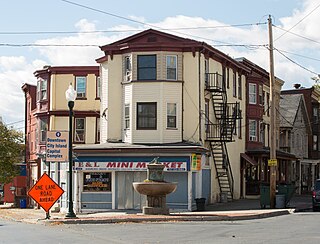
City Island is a mile-long island in the Susquehanna River between Harrisburg and Wormleysburg, Pennsylvania in the United States. It is used mainly for leisure and sports activities. Its previous names have included Turkey Island, Maclay's Island, Forster's Island and Hargast Island. The island can be reached from either side of the Susquehanna River by Market Street Bridge or, from the Harrisburg side and by pedestrians and cyclists only, by Walnut Street Bridge.

Downtown Harrisburg is the central core neighborhood, business and government center which surrounds the focal point of Market Square, and serves as the regional center for the greater metropolitan area of Harrisburg, Pennsylvania, United States.

Camp Curtin is a historic neighborhood in Harrisburg, Pennsylvania's northern end, located in Uptown and named for the American Civil War camp of the same name. It is bordered currently by landmarks of Fifth Street to the west, the railroad tracks next to the Pennsylvania Farm Show Complex to the east, Maclay Street to the south, and Reels Lane to the North.
Allison Hill is a neighborhood in Harrisburg, Pennsylvania, in the United States. It is located directly east of downtown Harrisburg on a bluff overlooking the older original borough along the Susquehanna River. The Hill comprises some sub-neighborhoods, such as Hillside Village; others have nicknames such as "The Ville" and the "Third Ward". Primarily, it can be separated into three smaller neighborhoods: North Allison Hill, Central Allison Hill, and South Allison Hill. It was named after William Allison, an early Harrisburg landowner who owned farms on the bluff outside of the then-Borough. First referred to as "Allison's Farm" or "Allison's Hill Farm", it finally became shortened to "Allison Hill" as the City expanded.

Midtown is a neighborhood in Harrisburg, Pennsylvania. Its zip code is 17102. The Midtown neighborhood is delineated by Forster Street to the south, Maclay Street to the north, 7th Street to the east, and the Susquehanna River to the west. Former Harrisburg Mayor William K. Verbeke is the namesake for Verbeke Street and first bought and developed the area. Midtown is home to the Pennsylvania Governor's Residence and the Broad Street Market, the oldest continually operated street market in the country.

Penns Creek is a 67.1-mile-long (108.0 km) tributary of the Susquehanna River in central Pennsylvania in the United States.
During the American Civil War, Pennsylvania was the second largest state in the Union, and Harrisburg was the state's capital. Located at the intersection of important railroads, Harrisburg proved an important supply and logistics center for the dissemination and transportation of materiel for the Union Army. Tens of thousands of new recruits were mustered into service or drilled at a series of Harrisburg-area United States Army training camps, including the sprawling Camp Curtin. Confederate forces under Lieutenant General Richard S. Ewell threatened Harrisburg during the June 1863 Gettysburg Campaign, but were instead called by General Robert E. Lee to return to Gettysburg campaign. Pennsylvania Governor Andrew Curtin ordered local workers to erect a series of forts and earthworks to protect the city, which then had a population of 13,000 residents.
Engleton is a section of the Midtown Harrisburg, Pennsylvania neighborhood created with a focus on architectural variety. It is roughly bounded by 2nd street to the west, Kelker Street to the north, 3rd street to the east and Reily Street to the south. Its Queen Anne and Italianate style homes were built in the 1890s by Benjamin H. Engle, who is the namesake of the area. Market appeal for these homes was created by varying the colors and treatments of the façades.

Wildwood Park is a public park and nature sanctuary in Harrisburg, Pennsylvania. The 229 acre park is known for its 90-acre shallow lake with over 6 miles of trails and mile-long boardwalk over the wetlands. The park is located within the city limits of Harrisburg; however, it is administered and maintained by the Dauphin County Parks and Recreation Department. Wildwood Park runs in line with Paxton Creek, a tributary of the Susquehanna River, on the northern side of Harrisburg and adjacent to the main campus of HACC, Central Pennsylvania's Community College. Paxton Creek feeds into the lake, which comprises 60% of the Park. A section of the old Pennsylvania Canal runs parallel to the western trail. The remainder of the park is mixed deciduous forest, and an artificial meadow overlooks the eastern side of the lake. Wildwood Park is also part of the Capital Area Greenbelt.

Harrisburg's Market Square is located in Downtown Harrisburg at the intersection of 2nd and Market Streets. The square was created in 1785. Since then, it has traditionally been the navigational center of the city, and experienced a post-1980s revival, with the creation of several new commercial, residential and retail spaces.

Camp Curtin Memorial Methodist Episcopal Church, also known as Curtin Heights Church and Camp Curtin Memorial-Mitchell United Methodist Church, is a historic Methodist Episcopal church located in Harrisburg, Dauphin County, Pennsylvania.

The Holocaust Memorial for the Commonwealth of Pennsylvania is a Holocaust memorial at Front and Sayford Streets along Riverfront Park, in Harrisburg, Pennsylvania. It was conceived by a committee of Holocaust survivors in 1992 representing the Jewish Community Center of Harrisburg. In light of publicity given to the U.S. Holocaust Museum, a group of survivors that had lived in the Harrisburg area pressed for a local memorial. It was designed by David Ascalon for $200,000 on a site designated by the City of Harrisburg along the public park land adjacent to the Susquehanna River. The Memorial was dedicated in 1994. An annual Yom Hashoah observance is held at the site.
Riverside is a suburban neighborhood within the Uptown section of Harrisburg, Pennsylvania. It is bordered by Front Street and the Susquehanna River to the west, Vaughn Street to the north, 7th Street and Railroad tracks to the east, and Division Street to the south. Riverside is known for its diversity of housing stock in price, size, and style which typically contain yards, driveways, and proximity to both the Susquehanna River and Italian Lake.

Academy Manor is a historical suburban subdivision of the Riverside neighborhood within the Uptown section of Harrisburg, Pennsylvania. The neighborhood extends north from Front and Division Street up to the location of former Harrisburg Academy, west to Parkview Lane, and south back to Division St. It was established in the early 20th century with specific plans in terms of lot sizes, setbacks, and the kinds of buildings permitted.