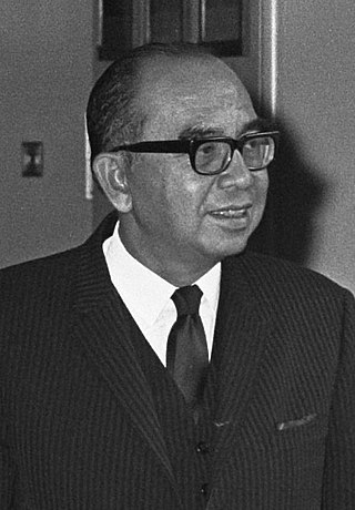
Allahyarham Orang Kaya Indera Shahbandar Tun Dato' Indera Haji Abdul Razak bin Hussein was a Malaysian lawyer and politician who served as the second prime minister of Malaysia from 1970 until his death in 1976. He also served as the first deputy prime minister of Malaysia from 1957 to 1970. He is referred to as the Father of Development.

Hussein bin Dato' Onn was a Malaysian lawyer and politician who served as the third Prime Minister of Malaysia from the death of his predecessor Abdul Razak Hussein in 1976 to his retirement in 1981. Moreover, he was the Member of Parliament (MP) for Sri Gading from 1974 to 1981, representing Barisan Nasional (BN) and United Malays National Organisation (UMNO). He was granted the soubriquet Father of Unity.

Banting is a town and the seat of Kuala Langat District, Selangor, Malaysia. Banting has a population of 93,497. The postal code for Banting is 42700 and is administered by the Zone of 15 and 19 of the Kuala Langat Municipal Council. It is situated on the banks of Langat River. It is a Rest Town or Bandar Persinggahan of Federal Route 5. The historical Jugra, a former royal town of Selangor is situated near Banting. Banting is located near the beaches of Morib, as well as hills, forest and farms. Banting is an agricultural hub. Its main agricultural resources include oil palm plantations, poultry farms, betel leaves and it has a number of industrial areas. It is also the home town of the Malaysian badminton player Rashid Sidek.

Bandar Baru Bangi is a township and satellite town of Kajang situated in Hulu Langat District, in southeastern Selangor, Malaysia.

Rawang is a town and a mukim in Gombak District, Selangor, Malaysia, about 23 km northwest of city centre Kuala Lumpur.

Tun Dr. Ismail bin Abdul Rahman was a Malaysian politician who served as the second Deputy Prime Minister of Malaysia from September 1970 to his death in August 1973. A member of the United Malays National Organisation (UMNO), he previously held several ministerial posts.

Brickfields is a neighbourhood located on the western flank of central Kuala Lumpur, Malaysia. It is known as Kuala Lumpur's Little India due to the high percentage of Indian residents and businesses. Brickfields has been ranked third in Airbnb's list of top trending destinations.
Bandar Tun Razak is a township and parliamentary constituency in Kuala Lumpur, Malaysia. It is named after the second Prime Minister of Malaysia, Tun Abdul Razak.
Taman Tun Dr Ismail is a mid-sized township in Kuala Lumpur, Malaysia. Situated on the border of Kuala Lumpur and Selangor, it is within the vicinity of other townships including Bandar Utama Damansara, Damansara Utama, Mutiara Damansara. It also neighbours Bukit Kiara and Sri Hartamas and is within easy access of Bangsar and Damansara Heights. This township is in the Federal Territory of Kuala Lumpur with Kuala Lumpur City Hall (DBKL) as its local authority. It is primarily a residential neighborhood with businesses ranging from retail shops, restaurants and offices. Menara Ken and Plaza VADS are the two high-rise office buildings in TTDI. The township was named after Tun Dr. Ismail bin Abdul Rahman, Malaysia's first ambassador to the United States and a Malaysian representative to the United Nations, before becoming Malaysia's Deputy Prime Minister in 1970. Taman Tun Dr. Ismail is often abbreviated as "TTDI".

Bandar Sungai Long is a main township in Cheras and Kajang, Selangor, Malaysia. Bandar Sungai Long was designed for a population of 10,000 residents. The majority population in this township are Chinese with a minority of Indians and Malays living in this township.

Wangsa Maju is a township and a constituency in Kuala Lumpur, Malaysia. This area is surrounded by Setapak, Taman Melati and Gombak district in Selangor. Wangsa Maju is one of the major suburbs in Kuala Lumpur.

Kampung Datuk Keramat or more commonly referred to as Keramat among the locals is a large zone in the Titiwangsa constituency, falling within the boundary of the Federal Territory of Kuala Lumpur, Malaysia. It is located northeast of downtown Kuala Lumpur and borders the district of Ampang in Selangor. The Klang River runs roughly from northeast to the west and acts as a natural divider of Keramat and Ampang.

Balakong; Chinese: 無拉港) or Cheras South; Chinese: 蕉賴南區) is a township in Hulu Langat District, Selangor, Malaysia. Located to the southeast of Greater Kuala Lumpur, the township consists mainly of residential condominiums, office complexes and factories. Notable landmarks in Balakong include AEON Mall Cheras Selatan and Sin Ann Meow Temple (星安庙).
Bangsar Park was the first residential area to be developed within the area which is now known as Bangsar in Kuala Lumpur, Malaysia. It is a much sought-after residential and commercial address in the Klang Valley.
Bandar Tun Hussein Onn is a township in 11th-Mile Cheras in Bangi constituency, Selangor, Malaysia. It is primarily a residential area, established in the early 1990s. It is situated about 13 km southeast of central Kuala Lumpur and 7.5 km north of Kajang.

Sri Permaisuri is a township in Cheras, Kuala Lumpur, Malaysia. It is located near Bandar Tun Razak and Salak South. It was opened for residential housing in 2000. The major types of housing there are apartments and condominiums.
Kampung Pandan is a village/settlement located in the Titiwangsa constituency in eastern Kuala Lumpur, Malaysia, surrounded by Ampang, Maluri, Pudu and Bukit Bintang. Once a small settlement, Kampung Pandan has now grown and developed tremendously.

Taman Midah is a 262-acre township in Cheras, Kuala Lumpur, Malaysia. The township probably takes its name from the Midah River which flows into a small lake to the east.