
Kajang is a town in Hulu Langat District, Selangor, Malaysia, located southeast of Kuala Lumpur. Kajang, along with much of Hulu Langat District, is governed by the Kajang Municipal Council. Kajang town is located on the eastern banks of the Langat River. It is surrounded by Cheras, Semenyih, Bangi, Putrajaya and Serdang.
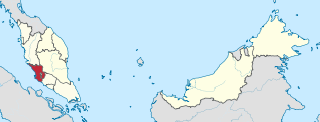
Selangor, also known by the Arabic honorific Darul Ehsan, or "Abode of Sincerity", is one of the 13 states of Malaysia. It is on the west coast of Peninsular Malaysia and is bordered by Perak to the north, Pahang to the east, Negeri Sembilan to the south, and the Strait of Malacca to the west. Selangor surrounds the federal territories of Kuala Lumpur and Putrajaya, both of which were previously part of it. Selangor has diverse tropical rainforests and an equatorial climate. The state's mountain ranges belong to the Titiwangsa Mountains, which is part of the Tenasserim Hills that covers southern Myanmar, southern Thailand and Peninsular Malaysia, with Mount Semangkok as the highest point in the state.
The North–South Expressway is a network of tolled controlled-access highways running through the west coast of Peninsular Malaysia. The expressway network consists of the northern and southern route, having a total length of 772 kilometres. Running through seven states and connecting the Thailand and Singapore borders, the North–South Expressway is an important thoroughfare for local, interstate and international traffic. The expressway is part of route AH2, a designation of the Asian Highway Network.
Federal Highway is a Malaysian controlled-access highway connecting the capital city of Kuala Lumpur, and Klang, Selangor. The highway starts from Seputeh in Kuala Lumpur to Klang, Selangor. It is the busiest highway in Klang Valley during rush hour from/to Kuala Lumpur. The Federal Highway is coded as Federal Route 2.
The East Coast Expressway is an interstate controlled-access highway running parallel to the northeastern coast of Peninsular Malaysia. The currently operational 433-kilometre (269-mile) segment of the expressway runs through Karak, Pahang and Kuala Nerus, Terengganu.

Malaysian Federal Roads System, is the main national road network in Malaysia. All Federal Roads in Malaysia are under the purview of the Ministry of Works (MOW). According to the Ministerial Functions Act 1969, the MOW is responsible to plan, build and maintain all Federal Roads gazetted under the Federal Roads Act 1959. However, most of the Federal roads' projects were built and maintained by the Malaysian Public Works Department (JKR), which is also one of the implementing agencies under the MOW.
The Federal Route 1 is the first federal road in Malaysia, the oldest federal road in Malaysia, and among the nation's earliest public roadways ever constructed. The Federal Route 1 was the backbone of the road system in the western states of Peninsular Malaysia before being supplanted by the North–South Expressway.
The Federal Route 2 is a major east–west oriented federal highway in Malaysia. The 276.9 kilometres (172 mi) road connects Port Klang in Selangor to Kuantan Port in Pahang. The Federal Route 2 became the backbone of the road system linking the east and west coasts of Peninsula Malaysia before being surpassed by the East Coast Expressway E8.

Federal Route 3 is a main federal road running along the east coast of Peninsula Malaysia. The 739 kilometres (459 mi) federal highway connects Rantau Panjang in Kelantan until Johor Bahru in Johor. The entire FT3 highway is gazetted as a part of the Asian Highway Network route 18.
Federal Route 5 is one of the three north–south oriented backbone federal roads running along the west coast of Peninsular Malaysia, Malaysia. The 655.85 kilometres (408 mi) federal highway runs from Jelapang, Perak in the north to Skudai, Johor in the south.
East–West Highway or also known as Gerik–Jeli Highway, Kulim–Baling Highway and Titi Karangan–Gerik Highway, Federal Route 4, Asian Highway Route 140 is the 215 kilometres (134 mi) federal highway constructed by the Malaysian Public Works Department (JKR) to shorten the journey from Kota Bharu, Kelantan to northwestern towns and cities of Malaysia such as Alor Star, Kedah and Penang. The highway connects Gerik, Perak in the west to Jeli, Kelantan in the east, before being extended further to Lunas, Kedah.
The Kuala Lumpur–Seremban Expressway East–West Link Expressway is a main expressway in Kuala Lumpur, Malaysia. This 8.1 km (5.0 mi) expressway links Kuala Lumpur in the north to Seremban, Negeri Sembilan in the south.
Federal Route 55 or Jalan Kuala Kubu Bharu–Teranum–Raub is a 62-km federal road connecting the states of Selangor and Pahang in Malaysia. It is the first federal road ever constructed in Pahang. The road connects Kuala Kubu Bharu, Selangor to Teranum near Raub in Pahang where it meets Federal Route 218. It is the main access route to Fraser's Hill.
Federal Route 68, also known as Jalan Gombak or Jalan Karak Lama, is a federal road in Malaysia that links the city of Kuala Lumpur to Bentong, Pahang. Before Kuala Lumpur–Karak Expressway E8/FT2 was built, the road was used to be a part of Kuala Lumpur–Kuantan Road FT2; however, due to its sharp corners, narrow roadway and lack of safety features, a replacement highway known as the Kuala Lumpur–Karak Highway FT2 was built, causing the former Kuala Lumpur–Bentong section to be re-gazetted as the Federal Route 68.

Ampang–Kuala Lumpur Elevated Highway (AKLEH), Ampang–Kuala Lumpur Elevated Highway, is the first elevated highway in Malaysia. The 7.9 km (4.9 mi) elevated highway connects Ampang and Kuala Lumpur. This highway was built to reduce traffic congestion at Jalan Ampang and make access to the city more convenient. Motorcycles and other vehicles with two wheels were banned from using this highway for safety reasons; the ban on motorcycles was lifted on 19 June 2008 because of escalating fuel prices.
Ipoh–Lumut Highway, Federal Route 5, is a 70.7-km federal highway in Perak, Malaysia, connecting the Perakian capital city of Ipoh in the east to Lumut near Sitiawan in the west. The Ipoh–Lumut Highway consists of a 22.7-km super two highway from Jelapang to Seputeh and a 48-km divided highway from Seputeh to Lumut. This highway is a part of the Federal Route 5 and serves as the final section of the FT5 route.

Federal Route 22, Asian Highway Route AH150, is a 310-kilometre (193 mi) federal highway in Sabah, Malaysia, which is also a component of the larger Pan Borneo Highway network. It starts from Tamparuli and ends at Sandakan. The section running from Tamparuli to Ranau, which is known as Tamparuli-Ranau Highway, crosses the Crocker Range just to the south of Mount Kinabalu.

Greater Kuala Lumpur is the geographical term that determines the boundaries of metropolitan Kuala Lumpur in Malaysia. Though similar to the term "Klang Valley", there remains a variation between the two. Ranked as the 30th-largest in Asia, it covers a total land size of 13,565.61km2.

The Malaysian Expressway System is a network of national controlled-access expressways in Malaysia that forms the primary backbone network of Malaysian national highways. The network begins with the Tanjung Malim–Slim River tolled road which was opened to traffic on 16 March 1966, later North–South Expressway (NSE), and is being substantially developed. Malaysian toll road-expressways are built by private companies under the supervision of the government highway authority, Malaysian Highway Authority. While toll-free expressways are built by Malaysian Public Works Department or Jabatan Kerja Raya Malaysia (JKR) in Malay.
The following is an alphabetical list of articles related to Selangor.

