
Azad Jammu and Kashmir abbreviated as AJK and colloquially referred to as simply Azad Kashmir, is a region administered by Pakistan as a nominally self-governing entity and constituting the western portion of the larger Kashmir region, which has been the subject of a dispute between India and Pakistan since 1947. Azad Kashmir also shares borders with the Pakistani provinces of Punjab and Khyber Pakhtunkhwa to the south and west, respectively. On its eastern side, Azad Kashmir is separated from the Indian union territory of Jammu and Kashmir by the Line of Control (LoC), which serves as the de facto border between the Indian- and Pakistani-controlled parts of Kashmir. Geographically, it covers a total area of 13,297 km2 (5,134 sq mi) and has a total population of 4,045,366 as per the 2017 national census.

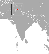
The western woolly flying squirrel is a species of very large flying squirrel in the genus Eupetaurus. It is native to northern Pakistan and northwestern India. It was long considered the only species in the genus until the description of two other species in 2021. Until recently, scientific knowledge of this rare species was limited to 11 skins collected in the late nineteenth century. However, recent research has confirmed that it remains in Kashmir. It is among the longest members of the family Sciuridae, and one of the biggest gliding animals known. Observations confirm that despite its size, it does glide effectively, like other flying squirrels.

Muzaffarabad is a city in Pakistani-administered Azad Kashmir in the disputed Kashmir region. It is the largest city and the capital of Azad Kashmir, which is a Pakistani-administered administrative territory.

The Aravalli West Thorn Scrub Forests, formerly known as Northwestern thorn scrub forests, is a xeric shrubland ecoregion of Pakistan and Northern India, stretching along the border lowlands and hills between the two countries. Once covered in deciduous forest, this ecoregion has been degraded through agriculture and the extraction of timber so that it currently has a scanty covering of thorny scrub dominated by such trees as Acacia senegal, Acacia leucophloea and Prosopis cineraria. Where the soils are particularly saline, there are patches of semi-desert. A number of mammals are found in this habitat, including about four hundred species of bird. Some small areas are protected but the collection of firewood and the conversion of the land to subsistence farming continues.

Operation Gibraltar was the codename of a military operation planned and executed by the Pakistan Army in the territory of Jammu and Kashmir, India in August 1965. The operation's strategy was to covertly cross the Line of Control (LoC) and incite the Muslim-majority Kashmiri population's uprising against the Indian Government. The military leadership believed that a rebellion by the local Kashmiri population against Indian authorities would serve as Pakistan's casus belli against India on the international stage.

The Deccan thorn scrub forests are a xeric shrubland ecoregion of south India and northern Sri Lanka. Historically this area was covered by tropical dry deciduous forest, but this only remains in isolated fragments. The vegetation now consists of mainly of southern tropical thorn scrub type forests. These consist of open woodland with thorny trees with short trunks and low, branching crowns; spiny and xerophytic shrubs; and dry grassland. This is the habitat of the great Indian bustard and blackbuck, though these and other animals are declining in numbers; this area was at one time home to large numbers of elephants and tigers. Almost 350 species of bird have been recorded here. The remaining natural habitat is threatened by overgrazing and invasive weeds, but there are a number of small protected areas which provide a haven for the wildlife. Trees in these forests have adapted to not require much water.
The wildlife of Iraq includes its flora and fauna and their natural habitats. Iraq has multiple biomes from mountainous region in the north to the wet marshlands along the Euphrates river. The western part of the country is mainly desert and some semi-arid regions. As of 2001, seven of Iraq's mammal species and 12 of its bird species were endangered. The endangered species include the northern bald ibis and Persian fallow deer. The Syrian wild ass is extinct, and the Saudi Arabian dorcas gazelle was declared extinct in 2008.

The Azad Kashmir Regiment is one of six infantry regiments in the Pakistan Army named after Azad Kashmir. It holds the distinction of being the only Battle Born Regiment in South Asia, formed by locals of Azad Kashmir to fight against Dogra Raj and it is the first regiment raised after Pakistan's independence. With the Regimental Centre at Mansar Mansar Camp in Attock District, the Regiment has gallantly participated in all Operations and Wars fought by the Pakistan Army

The wildlife of Pakistan comprises a diverse flora and fauna in a wide range of habitats from sea level to high elevation areas in the mountains, including 195 mammal, 668 bird species and more than 5000 species of Invertebrates. This diverse composition of the country's fauna is associated with its location in the transitional zone between two major zoogeographical regions, the Palearctic, and the Oriental. The northern regions of Pakistan, which include Khyber Pakhtunkhwa and Gilgit Baltistan include portions of two biodiversity hotspot, Mountains of Central Asia and Himalayas.
The Kashmir gray langur is an Old World monkey, one of the langur species. It is a leaf-eating monkey.
Kazinag National Park is a national park in Baramulla city of the Baramulla district in the Indian union territory of Jammu and Kashmir notified under Wild Life Protection Act 1972. It is part of a proposal for a trans-Karakoram peace park with Pakistan. The area of Kazinag National Park is 160 square kilometres, and it was commissioned in 1992. The national park is located on the north bank of the Jhelum River.

The Leepa Valley is an arable valley situated in the Jehlum Valley of Azad Jammu and Kashmir, Pakistan. It is located approximately 110 kilometres (68 mi) from the capital city of Muzaffarabad. The total area of Leepa is 9km. The valley is divided into the Nowkot, Kasirkot, Dao Khan, Leepa, and Chananian sectors.The most beautiful part of its is Dao Khan, and Nowkot. Some Major casts of Leepa is Malik, sayed, Awan, Chodary. The famous point of Leepa valley is Shamas bari view. There is one famous River ,Qazi Nagh.
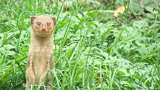
The small Indian mongoose is a mongoose species native to Iraq and northern India; it has also been introduced to several Caribbean and Pacific islands.
Sheikh Badin National Park is located near Darra Pezu in the Dera Ismail Khan and Lakki Marwat districts of Khyber Pakhtunkhwa, Pakistan. It is located among the Sheikh Badin Hills, which is an eastern extension of the Sulaiman Mountains. The park was established in 2003 and covers an area of 15,540 hectares. Here live two tribes one of which are mughals who came here after war of independence against Britain in 1857 and the others are syed who claim to be descendants of shiekh Abdul Qadir Jelaani.
Sardar Muhammad Abdul Qayyum Khan was a Kashmiri politician who also served as the president and prime minister of Azad Kashmir. He also remained President of All Jammu and Kashmir Muslim Conference for over 20 years. He belonged to the Dhund-Abbassi Tribe.
The Azad Kashmir Regular Force (AKRF), formerly known as the Kashmir Liberation Forces(KLF), were the irregular forces of Azad Kashmir until 1948. They then were taken over by the government of Pakistan and converted into a regular force. In this form, the unit became part of the country's paramilitary forces, operating out of the nominally self-governing territory of Azad Jammu and Kashmir. The AKRF was altered from a functioning paramilitary force and merged into the Pakistan Army as an infantry regiment following the Indo-Pakistani War of 1971.
Barnala is a city located in the state of Azad Jammu & Kashmir, Pakistan.
The Ghamot National Park Ghamot National Park is a national park in Azad Kashmir, Pakistan. It is located in Neelam District of AJK and it was established in 2004. Conservation efforts in the Gumot National Park are funded by the Global Environment Facility Small Grants Programme and implemented by the Himalayan Wildlife Foundation. The national park is significant as it hosts a connected population of the threatened Himalayan Brown Bear of Pakistan, connected through a network of national parks in northern Pakistan including the Deosai National Park and Musk Deer National Park. The park also hosts a population of the threatened musk deer.
The Gurez National Park, also known as Musk Deer National Park, is one of the protected areas of Pakistan. It is located in Neelum District in Azad kashmir, Pakistan, besides the Neelum River in the Gurez valley. It is located in the high Himalayas and Pir Panjal Range. It is a thirty-five minute drive from Gurez tehsil. It is also known as Gurez valley national park.

Barmang is a town in Rawalakot teshil of Poonch District, Azad Kashmir, Pakistan and has an elevation of 1,736 metres. Barmang is situated nearby to Army Area and the town Khai Gala.
