


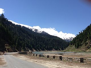
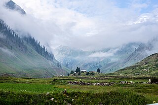
Lulusar-Dodipat National Park is located in the Kaghan Valley in Mansehra District of Khyber-Pakhtunkhwa, Pakistan. The park was created in 2003. [1] The scenic Dudipatsar Lake and Lulusar Lake and peaks are in the park.
Lulusar-Dodipat National Park is located in the Kaghan Valley in Mansehra District of Khyber-Pakhtunkhwa, Pakistan. The park was created in 2003. [1] The scenic Dudipatsar Lake and Lulusar Lake and peaks are in the park.
The flora includes the trees, shrubs, perennials, and herbs of the Himalayan Western Himalayan subalpine conifer forests and higher elevation Western Himalayan alpine shrub and meadows ecoregions. Some of the park's fauna includes the snow leopard, black bear, marmot, weasel, lynx, leopard, Himalayan snowcock, and the snow partridge. The park's lakes and wetlands habitats are of significant ecological importance for resident fauna and migratory waterfowl. [1]
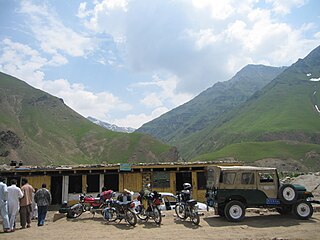
The road is accessible by cars and motorbikes. The 2005 Kashmir earthquake in North Pakistan made access more difficult. However, since 2006 the Pakistan government has taken steps to restore tourism in the Kaghan Valley, including rebuilding and new tourism facilities and infrastructure. [2]
Saiful Muluk National Park, with Lake Saiful Muluk, is adjacent to Lulusar-Dodipat National Park in the Kaghan Valley region. Together the parks protect 88,000 hectares (220,000 acres). [1]

Pyala Lake (Jalkad) Pyala Lake is a round shape lake located in Jalkhand, Kaghan Valley, Mansehra District of Khyber Pakhtunkhwa. This glacial lake is situated at the boundary of the LDNP along adjacent to the Jalkad Nullah. It is a source of freshwater and is surrounded by a dry temperate zone and a wet monsoon temperate zone. Pyala Lake is a tourist attraction due to its bowl-shaped location atop a mountain and its natural setting.[ citation needed ] The lake is situated on the way to Lulusar Lake from Naran, approximately 40 kilometers away.
Dohian Mali lake Jalkad Located approximately 5 km from the Nori Top road base camp, at the beginning of Jalkad Mali, are two lakes known as Dohian Mali lakes. The lakes are surrounded by Porbinar on one side, Kutawai Nullah on the front, and Jalkad Nullah on the other. The local name for these lakes is Doyi Mali, and there are two lakes in the vicinity, one smaller and the other slightly larger in size.
Sat Sari Mala Lake The name "Sat Sri Mala" refers to a chain of seven alpine lakes in the LDNP, situated at an altitude of 3,050 meters in the inner mountain ranges of the Western Himalayas. The name is derived from the local language where "Sat" means seven and "Sri Mala" refers to the chain of lakes that are connected through waterfalls. The Sat Sar Mala Lakes are a rare destination in the LDNP, with five of the seven lakes forming cascades. Surkhail Lake, located at an altitude of 14,100 feet, is the highest and topmost cascade lake. Due to its remote location, the region has a dry temperate zone and a wet monsoon temperate zone, providing visitors with a diverse range of flora and fauna. These lakes are primarily visited by trekkers and adventurers seeking to explore the stunning glacial lakes and majestic mountains. The trek to the lakes begins just before the village of Gittidas, located between Jalkhad and Babusar Pass. Access to the lakes is limited to a short period between August and September, as the lakes are snowbound for most of the year. 2.3.6 Daraham Sir Lake Lake Daraham Sir is a glacial lake situated to the left of Babusar Top at an altitude of approximately 4,100 meters in the Western Himalayas at an elevation of 4,058 meters. It is located in the Kaghan Valley within the Khyber-Pakhtunkhwa province of Pakistan. The lake is accessible via a trek from Lulusar Lake and provides an ideal habitat for trout breeding. It is surrounded by a dry temperate zone and a wet monsoon temperate zone. When travelling eastwards from Chilas on the Karakoram Highway, Lake Daraham Sir is located near the larger Sambaksar Lake and Ganai Gali. Dharamsar Lake is located in close proximity to the border of Khyber Pakhtunkhwa and Azad Jammu and Kashmir, just south of the point where the three regions of Khyber Pakhtunkhwa, Azad Kashmir and Gilgit-Baltistan meet.
Sambak Sir Lake Nestled in the inner mountain ranges of the Western Himalayas, It is a stunning glacial lake that sits at an altitude of 3,300 meters. The lake will be accessed by trekking from Lulusar Lake and is renowned for its trout breeding grounds. It is surrounded by a dry temperate zone and a wet monsoon temperate zone. The lake's name "Sambaksar" comes from the local language and means "Wall" which is fitting as it is situated next to a wall-like feature at such a high altitude. To visit this Lake, one must venture beyond Naran in the Kaghan Valley. The journey begins from Basel, with a slight deviation from the well-known route to Dudipatsar Lake leading to the Samabsar Lake and Dharamsar Lake. The Sambaksar Lake is larger than Dharamsar Lake and even in August/September, the lake's water is not entirely melted.


Northern Pakistan is a tourism region in northern and north-western parts of Pakistan, comprising the administrative units of Gilgit-Baltistan, Azad Kashmir, Khyber Pakhtunkhwa, Islamabad Capital Territory and the Rawalpindi Division in Punjab. The first two territories are a part of the wider Kashmir region. It is a mountainous region straddling the Himalayas, Karakoram and the Hindu Kush mountain ranges, containing many of the highest peaks in the world and some of the longest glaciers outside polar regions. Northern Pakistan accounts for a high level of Pakistan's tourism industry.

Saiful Muluk is a mountainous lake in northern Pakistan, located at the northern end of the Kaghan Valley, near the town of Naran in the Saiful Muluk National Park. At an elevation of 3,224 m above sea level, the lake is located above the tree line, and is one of the highest lakes in Pakistan.
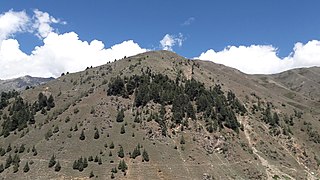
Lulusar, , or Lalusar, is a group of mountain peaks and a lake in the Kaghan Valley in the Khyber-Pakhtunkhwa province of Pakistan.

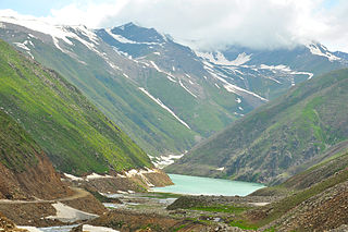
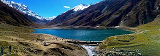
Dudipatsar Lake, also known as Dudipat Lake, is a lake encircled by snow clad peaks in Lulusar-Dudipatsar National Park. The lake lies in the north end of the Kaghan Valley, in the Mansehra District, Khyber Pakhtunkhwa province, in northern Pakistan.
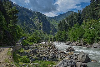
The Kunhar River or River Kunhar, is a 177 kilometres (110 mi) long river, located primarily in the Khyber Pakhtunkhwa province, northern Pakistan. It is in the Indus River watershed basin.

Babusar Pass or Babusar Top is a mountain pass in Pakistan at the north of the 150 km long Kaghan Valley, connecting it via the Thak Nala with Chilas on the Karakoram Highway (KKH). It is the highest point in Kaghan Valley that can be easily accessed by cars.

Ansoo Lake, is a tear-shaped lake located in Kaghan Valley in Mansehra District of Khyber Pakhtunkhwa the province of Pakistan. It is located at an elevation of 4,245 metres (13,927 ft) above sea level and considered one of the highest lakes of the Himalaya Range. The lake is situated near Malika Parbat, the highest mountain in Kaghan Valley. The name of the lake owes to its teardrop shape; the Urdu word ansoo means "teardrop". The lake is said to have been discovered in 1993 by Pakistan Air Force pilots who were flying at a relatively low altitude over the area.
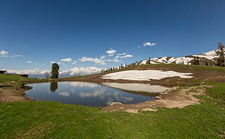
Payee Lake is situated in centre of meadow in Payee, near Shogran in Kaghan Valley, Khyber Pakhtunkhwa the province of Pakistan. It is located at the height of almost 2,895 metres (9,498 ft). It is surrounded by Makra Peak, Malika Parbat, Musa ka Musala and the mountains of Kashmir.The lake is accessible via Kiwai passing through Shogran by a jeep track. There is a problem in breathing there due to elevation.

Shogran is a hill station situated on a plateau in the Kaghan Valley of Mansehra District, Khyber Pakhtunkhwa in northern Pakistan at a height of 2,362 metres (7,749 ft) above sea level. It has been a popular tourist attraction in recent years.
Naran is a town and popular tourist destination in upper Kaghan Valley in the Mansehra District of the Khyber Pakhtunkhwa province of Pakistan. It is located 119 kilometers (74 mi) from Mansehra city at the altitude of 2,409 meters (7,904 ft). It is located about 65 kilometers (40 mi) away from Babusar Top. It is one of the most popular tourist attraction locally as well as internationally. Naran valley is also Pakistan's most visited Valley, around 1.5 million people visit Naran valley every year.

Rerh/Reerh is a small village near Atter Shisha in the UC Peeran in Mansehra District in the Khyber-Pakhtunkhwa province of Pakistan.
Saiful Muluk National Park is situated in the Kaghan Valley within the Mansehra District of Khyber Pakhtunkhwa, Pakistan. The park was officially declared in 2003, and is centred upon the alpine Saiful Muluk Lake.
Mahandri is a village in the Kaghan Valley in the Mansehra District of Khyber-Pakhtunkhwa province of Pakistan. There is a road from Balakot that ascends along the Kunhar River through lovely forests to Mahandri and to the villages of Paras, Shinu and Jared. A trekking track to reach Ansoo Lake begins from Mahandri, which is 40 km below Naran Village, but this is an alternative to the Lake Saiful Muluk route and the difficulties are unknown.

Lalazar, is a tourist spot at an elevation of 3,123 metres (10,246 ft) above the sea level, located in upper Kaghan Valley in Mansehra District of Khyber Pakhtunkhwa Province of Pakistan.
Besal is a small village located in Kaghan Valley, Mansehra District of Khyber Pakhtunkhwa province of Pakistan. It sits 3260 meters above sea level. It is adjacent to the Kunhar River, about 45 kilometers north of Naran. It is the starting point for hiking trails like Dudipatsar Trail. It is accessible by cars and motorbikes.
Saiful is a given name. Notable people with the name include:
Dharamsar is an alpine lake in the Kaghan Valley in the Khyber-Pakhtunkhwa province of Pakistan. It is located approximately 4,100 meters above sea level to the left of Babusar Top going eastwards from Chilas on the Karakoram Highway, next to the larger Sambaksar and Ganai Gali. Dharamsar lake is located close to the border of Khyber Pakhtunkhwa and Azad Jammu and Kashmir just south of the meeting point of all three of Khyber Pakhtunkhwa, Azad Kashmir and Gilgit-Baltistan.
Batakundi or Battakundi is a tourist town located 15 km east of Naran in Mansehra District, Khyber Pakhtunkhwa, Pakistan. It is located in the Kaghan Valley.
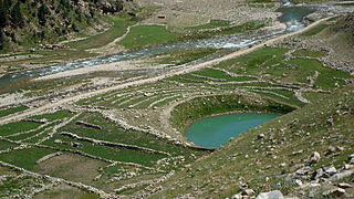
Pyala Lake is a round lake in Jalkhand, Kaghan Valley, Mansehra District of Khyber Pakhtunkhwa. It is about 40 kilometres (25 mi) from Naran.
35°01′N74°05′E / 35.017°N 74.083°E
| | This article about a protected area of Pakistan is a stub. You can help Wikipedia by expanding it. |
