Chitral District was the largest district in the Khyber-Pakhtunkhwa province of Pakistan, covering an area of 14,850 km², before splitting into Upper Chitral District and Lower Chitral District in 2018. Part of the Malakand Division, it was the northernmost district of Khyber Pakhtunkhwa. It shared a border with Gilgit-Baltistan to the east and with Swat and Dir districts of Khyber Pakhtunkhwa to the south. It also shared an international border with Afghanistan to the north and west. Afghanistan's narrow strip of Wakhan Corridor separated Chitral from Tajikistan in the north.

The Ghizer District, was a district in the westernmost part of the Gilgit-Baltistan region of Pakistan, before splitting into the current Ghizer and Gupis-Yasin districts in 2019. The capital of the district was Gahkuch.

Shandur Pass(Urdu: شندور) is a pass located in Ghizer, District of Gilgit Baltistan. It is often called 'Roof of the World.

The Sintra-Cascais Natural Park is a park on the Portuguese Riviera, one of the 13 Natural Parks of Portugal. While only established in 1994 as a Natural Park by the Portuguese Government, it has been protected since 1981. Its area is approximately 145 km2. The park includes the Serra de Sintra Mountain Range but extends all the way to the coast and Cabo da Roca, continental Europe's westernmost point. It contains the Castle of the Moors. Located within 25 km of Lisbon, the Sintra-Cascais Natural Park is a popular tourism area, with many different individual historical and natural sites and attractions. Sintra and Cascais are towns and municipalities in the Lisbon / Estoril Coast.
Sankan Biriwa is a mountain massif in the east of Sierra Leone with two peaks, both over 1,800 metres, the northernmost is the second highest in Sierra Leone at 1,850 m. The mountain is part of the Tingi Hills Forest Reserve.
Yulu Natural Reserve is a nature reserve in Nicaragua. It is one of the 78 reserves that are under official protection in the country.

The Tagus International Natural Park is a protected area in Portugal and Spain. It is an important area for the conservation of several species of birds that nest on the rugged banks of rivers and surrounding areas. It is also one of the lowest human density areas in the Iberian Peninsula.

Serra de São Mamede Natural Park is a natural park in the Serra de São Mamede range, Portugal. It is one of the 30 areas which are officially under protection in the country.

Serra de Montejunto Protected Landscape is a protected landscape in the Montejunto-Estrela mountain range, spanning the municipalities of Alenquer and Cadaval in Lisbon District, Portugal. It is the highest natural viewpoint of Estremadura, rising to 666 metres (2,185 ft) of altitude. The area is part of the Estremenho Limestone Massif. Geologically is 15 kilometres (9.3 mi) long and 7 kilometres (4.3 mi) wide, and is rich in caves, sewage ponds and prehistoric fossils.

The Kho or Chitrali people, are an Indo-Aryan ethnolinguistic group native to the Chitral District in Khyber Pakhtunkhwa and the Gupis-Yasin and Ghizer districts in Gilgit-Baltistan of Pakistan. They speak an Indo-Aryan language called Khowar.

Gilgit-Baltistan, formerly known as the Northern Areas, is a region administered by Pakistan as an administrative territory and consists of the northern portion of the larger Kashmir region, which has been the subject of a dispute between India and Pakistan since 1947 and between India and China since 1959. It borders Azad Kashmir to the south, the province of Khyber Pakhtunkhwa to the west, the Wakhan Corridor of Afghanistan to the north, the Xinjiang region of China to the east and northeast, and the Indian-administered union territories of Jammu and Kashmir and Ladakh to the southeast.

The Huon Peninsula montane rain forests is a tropical moist forest ecoregion in New Guinea. The ecoregion covers the mountains of northeastern New Guinea's Huon Peninsula.

The East African montane moorlands is a montane grasslands and shrublands ecoregion which occupies several high mountain peaks in Kenya, South Sudan, Tanzania, and Uganda.
Gupis @ Sumpis (Goopechh) Valley is located about 112 kilometers to the west of Gilgit on the bank of River Gilgit, District Ghizer, Gilgit-Baltistan, Pakistan. The Gupis is 2176 meters above sea level. This fort was once used by the military for defence purposes. Later the king (Raja) of the time lived in this fort for several years.
Niat Qabool Hayat Kakakhel was a Gilgit-Baltistani politician in Pakistan and, after 1973, assistant to the Governor of Gupis. Kakakhel was a member of the Central Asia Supreme Council and a senior member of the Aga Khan Council. He was a ruling official during the Frontier Crimes Regulations (FCR) period in the early 1970s.
Baha Lake is situated in Shandur Valley Tehsil Gupis of Ghizer District, Ghizer District, the westernmost part of the Northern Areas and northernmost territory of Pakistan. This lake is an important source of fresh water with full of trout.

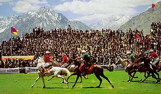
Shandur Polo Festival is a sports festival held annually from 7 to 9 July in the Shandur Top in Pakistan. The polo tournament is played between the teams of Gilgit District and Chitral District, under freestyle rules.

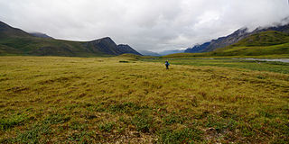
The Brooks–British Range tundra is an ecoregion spanning North America and Canada, and is one of the WWF Global 200 ecoregions.
The Rajang Mangroves National Park is a national park in Sarikei Division, Sarawak, Malaysia. It is home to species such as proboscis monkeys, silvered langurs, lesser adjutant storks, Irrawaddy dolphin and hornbills.

The Gupis-Yasin District is a district of Pakistan-administered Gilgit-Baltistan in the disputed Kashmir region. It is the westernmost district of the 14 districts of Pakistan-administered territory of Gilgit-Baltistan. The Gupis-Yasin District was created in 2019 from the Gupis Tehsil and the Yasin Tehsil, which were the two western tehsils of the former, larger Ghizer District.


