Related Research Articles
Loughborough Inlet is one of the lesser principal inlets of the British Columbia Coast. It penetrates the Coast Mountains on the north side of the Discovery Islands archipelago, running about 35 km (22 mi) from its head at the mouth of the Stafford River to Chancellor Channel and Cordero Channel, which are on the north side of West Thurlow Island. A further 14 km (8.7 mi) west along Chancellor Channel is Johnstone Strait.
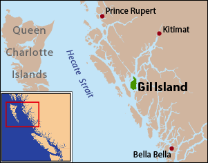
Gil Island is an island on the North Coast of British Columbia, Canada, located on the west side of Whale Channel in the entrance to Douglas Channel, one of the main coastal inlets, on the route of the Inside Passage between Pitt Island and Princess Royal Island. It is 26 km (16 mi) long, with a width ranging from 6 to 13 km, and an area of 231 km2. The only named summit on the mountainous island is Mount Gil, which faces the opening of Douglas Channel.
Dowager Island is an island in the North Coast region of British Columbia. To its west is Finlayson Channel, to it east Mathieson Channel. Susan Island lies to its north and Lady Douglas Island to its south. James Johnstone, one of George Vancouver's lieutenants during his 1791-95 expedition, first charted its west and east coasts in 1793. It was named by Captain Daniel Pender during his 1867-70 survey of the region.
Susan Island is an island in the North Coast of British Columbia, Canada. To its west is Finlayson Channel; to its east Mathieson Channel. Roderick Island lies to its north and Dowager Island to its south. James Johnstone, one of George Vancouver's lieutenants during his 1791-95 expedition, first charted its west and east coasts in 1793.

Pooley Island is an island in the North Coast region of British Columbia, Canada. To its west and southwest is Roderick Island, to its east Mathieson Channel. James Johnstone, one of George Vancouver's lieutenants during his 1791-95 expedition, first charted its north and east coasts in 1793. The island was later named after Charles Edward Pooley.
Finlayson Channel is a channel of the British Columbia Coast, Canada. It is a northern extension of Milbanke Sound. To its west are Swindle and Sarah Islands, to its east Roderick, Susan and Dowager Islands. It was first charted in 1793 by James Johnstone, one of George Vancouver's lieutenants during his 1791-95 expedition.

Mathieson Channel is a channel of the British Columbia Coast. It is a northern extension of Milbanke Sound. To its west are Pooley, Roderick, Susan and Dowager Islands, to its east the Don Peninsula. It was first charted in 1793 by James Johnstone, one of George Vancouver's lieutenants during his 1791-95 expedition.
Spiller Channel is a channel of the British Columbia Coast. It separates the Don Peninsula from Yeo Island. It was first charted in 1793 by James Johnstone, one of George Vancouver's lieutenants during his 1791–95 expedition.
Bullock Channel is a channel of the North Coast of British Columbia, Canada. It separates Yeo Island from the Coldwell Peninsula. It was first charted in 1793 by James Johnstone, one of George Vancouver's lieutenants during his 1791–95 expedition.
Yeo Island is an island in the North Coast region of British Columbia, Canada. It is separated from the Don Peninsula to its west by Spiller Channel, and from the Coldwell Peninsula to its east by Bullock Channel. It was first charted and circumnavigated in 1793 by James Johnstone, one of George Vancouver's lieutenants during his 1791–95 expedition.
Sarah Island is an island in the North Coast of British Columbia, Canada. It is separated from Princess Royal Island to its west by Tolmie Channel, and from Roderick Island to its east by Finlayson Channel. Its east coast was first charted in 1793 by James Johnstone, one of George Vancouver's lieutenants during his 1791-95 expedition.
Burke Channel is a channel in the Central Coast region of the Canadian province of British Columbia, separating the south and east coasts of King Island from the mainland. It was first charted in 1792 by James Johnstone, one of George Vancouver's officers during his 1791-1795 expedition. Vancouver named it "Burke's Channel" after Edmund Burke.
Fisher Channel is a channel in the Central Coast region of the Canadian province of British Columbia. To its west are Hunter and Denny Islands, to its east King Island. It was first charted in 1793 by George Vancouver during his 1791-95 expedition. He named it "Fisher’s Channel" after "a much-respected friend" Reverend John Fisher.

Princess Royal Channel is a channel in the North Coast region of the Canadian province of British Columbia, separating Princess Royal Island from the mainland. The southern half of the channel is also called Graham Reach, and the northern half Fraser Reach.
Chatfield Island is an island in the North Coast region of the Canadian province of British Columbia. To its north and west is Yeo Island, and to its east, Cunningham Island. It was named in 1876 by the Hydrographic Office of the British Admiralty after Captain Alfred John Chatfield, RN (1831-1910). Its north coast was charted in 1793 by George Vancouver, and its west coast by one of his lieutenants, James Johnstone, later that year.
Work Channel formerly Wark Channel is a channel in the North Coast region of the Canadian province of British Columbia. It lies to the northeast of the Tsimpsean Peninsula. It was named about 1837 by officers of the Hudson's Bay Company after John Work, born John Wark. It was first charted in 1793 by James Johnstone and Robert Barrie, two of George Vancouver's officers during his 1791-95 expedition.
Gilttoyees Inlet is an inlet in the North Coast region of the Canadian province of British Columbia. It extends north from Douglas Channel. Its name derives from the Haisla term for the inlet, Giltu'yis. It was first charted in 1793 by Joseph Whidbey and Robert Barrie, two of George Vancouver's officers during his 1791-95 expedition.

Mussel Inlet is in inlet in the North Coast region of the Canadian province of British Columbia. It is a northeast extension of Sheep Passage, and part of the Fiordland Conservancy.
Ursula Channel is a channel in the North Coast region of the Canadian province of British Columbia. It separates the east coast of Gribbell Island from the mainland. It was first charted in 1793 by Joseph Whidbey, master of the Discovery during George Vancouver’s 1791-95 expedition.
Spiller Inlet is an inlet in the North Coast region of the Canadian province of British Columbia. It forms the head of Spiller Channel. It was first charted in 1793 by James Johnstone, one of George Vancouver's officers during his 1791-95 expedition.
References
- ↑ "Devastation Channel". Geographical Names Data Base . Natural Resources Canada . Retrieved 2020-06-16.
- ↑ "Devastation Channel". BC Geographical Names .
- ↑ Vancouver, George, and John Vancouver (1801). A voyage of discovery to the North Pacific ocean, and round the world. London: J. Stockdale.
{{cite book}}: CS1 maint: multiple names: authors list (link)
53°40′09″N128°50′09″W / 53.66917°N 128.83583°W
| | This article about a location on the North Coast of British Columbia, Canada is a stub. You can help Wikipedia by expanding it. |