Geologically, the Diablo Range corresponds to the California Coast Ranges east of the Calaveras Fault in its northern section. For much of its length, it is paralleled by other sections of the California Coast Ranges to the west, the Santa Cruz Mountains across the southern San Francisco Bay and Santa Clara Valley, and the Santa Lucia Range across the Salinas Valley. To the west the north Diablo Range is bounded geologically from the East Bay Hills by the Calaveras Fault.[7] However, ecologically the East Bay Hills are part of the East Bay Hills/Western Diablo Range subregion, which along with the Diablo Range, falls within the Central California Foothills and Coastal Mountains Level III Ecoregion #6.[8]
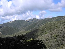
Though the average elevation is about 3,000 feet (910 meters), a summit of over 2,300 feet (700m) is considered high, mainly because the range is mostly rolling grassland and plateaus, punctuated by isolated peaks. Plateaus are usually at about 2,000–3,000 feet (610–910m). Hills rise to about 1,000 feet (300m), while foothills such those in the Santa Clara Valley, Livermore Valley and San Joaquin Valley are typically 400–1,000 feet (120–300m).
Canyons are usually 300–400 feet (91–122m) deep; valleys are often deeper but less steep-sided. Peaks often have high topographic prominence, as they are surrounded by valleys or lower hills or plateaus. Streams draining the eastern slopes of the Diablo Range include Hospital Creek and Ingram Creek. Stream draining the western slopes include Alameda Creek and Coyote Creek.
Peaks
The Diablo Range's peaks and ridges are between 2,517–5,241 feet (767–1,597m) and are distinct landmarks. Mount Diablo (3,849 feet (1,173m)), San Benito Mountain (5,241 feet (1,597m)), Mount Hamilton Ridge (4,230–4,260 feet (1,290–1,300m)), and Mount Stakes (3,804 feet (1,159m)) are four of the highest peaks in the range.
View of Mt. Diablo from Concord. Main peak at right, North Peak at left, Mt. Zion at center (scroll image L/R to view)
The soil of the Diablo Range consists of serpentine rocks alongside ophiolite. These rocks were formed alongside the original oceanic crust about 165 million years ago through rapid lava cooling. Segments of silicacarbonate rocks (altered serpentine) have been located alongside nearby mercury mines.
Much of the Diablo Range is located alongside the Franciscan Complex. Franciscan rocks, including basalt, graywacke, shale, and chert, were formed by the subduction of the oceanic crust during the late Jurassic and early Cretaceous periods. Overlaying Franciscan rocks have undergone metamorphism during the Cretaceous and Eocene eras, resulting in the vertical growth and formation of the range's mountainous slopes.
Over multiple centuries, weathering and erosion have impacted deposits of sedimentary rocks and fossils from the Eocene era and resulted in the formation of unusual rock features and deposits in the Diablo Range.[10]
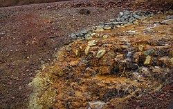
Mercury mining deposits are prevalent along much of the Diablo Range. The ore is mined from silica-carbonate rocks, which have a spongey-like formation and are produced in cinnabar and metacinnabar variations. The New Idria Mercury Mine produced much of the nation's mercury resources between 1854 and the early 1970s. Widescale mercury mining facilities in the Diablo Range date back to World War II mercury supply demands, and were later shut down by the latter half of the twentieth century. This mercury mining, most notably from New Idria, has resulted in the contamination of acid mine water into nearby wetlands and water sources, including the Panoche Creek and the San Joaquin River.[11]
Other materials, including copper, travertine, coal, gas, and oil reservoirs, were also mined along the Diablo Range.[10]
Human elements
The south edge (mostly Monument Peak) of the Mission Ridge as seen from Milpitas.
The Diablo Range is paralleled for much of its distance by U.S. Route 101 to the west and by I-5 to the east. Major routes of travel through the range include:
Since the range lies around 10–50 miles (16–80 kilometers) inland from the ocean, and other coastal ranges like the Santa Lucia Range and the Santa Cruz Mountains block incoming moisture, the range gets little precipitation. In addition, the average elevation of 3,000 feet (910m) is not high enough to catch most of the incoming moisture at higher altitudes.
Winters are mild with moderate rainfall, but summers are very dry and hot. Areas above 2,500 feet (762 m) get light to moderate snow in the winter, especially at the highest point, the 5,241ft (1,597 m) San Benito Mountain in the remote southeastern section of the range. However, though sites at the lower end get annual snowfall, it is typically light and melts too fast to be noticed. Once or twice a decade there is seriously deep and long lasting snowfall.
Mercury contamination near the southern end of the range is an ongoing problem, due to the New Idria quicksilver mines, which stopped production in the 1970s. Heavy mercury contamination has been documented in the San Carlos and Silver Creeks, which flow into Panoche Creek, and thence into the San Joaquin River. This has resulted in mercury contamination all the way downstream to the San Francisco Bay. Silver and San Carlos creeks provide a wetland environment in an otherwise arid region and are important for the ecology of the region. Mercury waste from calcine furnaces has polluted much of these abandoned mines and the biodiversity of the Diablo Range environment. In recent years, this contamination has been acknowledged by federal and state authorities and has been the focus of clean-up initiatives.[12] As of 2011, New Idria has been listed as a Superfund site and scheduled for cleanup.[13]
Energy development, suburbanization, and community projects have threatened the biodiversity of the Diablo Range. Notably, the encroachment of solar farms and wind turbines endangers the population of many rare species of flora and fauna. This biodiversity is a direct effect of the range's serpentine soil and chaparral climate.[14]
The most common trees are coast live oak (Quercus agrifolia) and blue oak (Quercus douglasii), with the largest blue oak growing in Alameda County. There are also good populations of California buckeye (Aesculus californica), and California black oak (Quercus kelloggii). The gray pine (Pinus sabiniana) and rarer Coulter pine (Pinus coulteri) can be found at all elevations, especially between 800–3,000 feet (240–910m). Coulter pine reaches its northern limit on northern of Mt. Diablo. The conifers at higher elevations in the Diablo Range include knobcone pine (Pinus attenuata), Jeffrey pine (Pinus jeffreyi) and ponderosa pine (Pinus ponderosa).
Fauna
Three tule elk in Basking Ridge Park just north of U.S. Highway 101, which is a barrier to elk migration to the Coast Range
The Diablo Range attracts far more raptors than coastal forests, such as red-tailed hawks. Golden eagle nesting sites are found[17] in the Diablo Range, reaching their highest density in southern Alameda County.[18][19][20]
A species of millipede, Illacme plenipes, is endemic to the southern Diablo Range. First described in 1926, then not seen again until 2005, the species has more legs than any other species of millipede, with one specimen having 750.[22]
Many indigenous groups have settled alongside the Diablo Range, including the Ohlone, Yokuts, Miwok, Volvon, Muwekma, Tamien Nation, Amah Mutsen, Chalon, and Salinan. These indigenous communities maintained a sacred connection to the mountain range and local topography. Pre-colonial contact, these Native American communities preserved and respected their surrounding land, which had granted life. Specifically, Mount Diablo stood as a sacred symbol for multiple generations, representing the relationship between humans and their local environment. Multiple cultural artifacts of ceremonial importance have been unearthed and excavated from protected state parks within the Diablo Range.
In the early 1800s, the Volvon were relocated to Spanish Mission systems. Their removal greatly impacted the local Diablo Range environment and established biodiversity. The Volvon resisted Spanish settlement throughout the 1820s, eventually declining in population due to epidemics.[23]
↑ R. C. Crane (1995). "Geology of Mount Diablo Region and East Bay Hills". In E. M. Sangines; D. W. Andersen; A. B. Buising (eds.). Recent Geologic Studies in the San Francisco Bay Area. Vol.76. Pacific Section, Society for Sedimentary Geology (S.E.P.M.). pp.87–114. Retrieved July 3, 2024.
↑ G. E. Griffith, J. M. Omernik, D. W. Smith, T. D. Cook, E. Tallyn, K. Moseley, C. B. Johnson (2016). "Ecoregions of California". Open-File Report (Report). Reston, Virginia: U.S. Environmental Protection Agency and U.S. Geological Survey. doi:10.3133/ofr20161021. Retrieved June 7, 2025.{{cite report}}: CS1 maint: multiple names: authors list (link)
↑ C. Michael Hogan, Paul Hoffey et al. al., Environmental Impact Report for the Aiassa Site off Mount Hamilton Road, Santa Clara County, Ca., Santa Clara County Document EMI 7364W1 SCH88071916, August, 1989
This page is based on this Wikipedia article Text is available under the CC BY-SA 4.0 license; additional terms may apply. Images, videos and audio are available under their respective licenses.