Dickinson Theodore Roosevelt Regional Airport

Last updated

Dickinson Theodore Roosevelt Regional Airport
DIK logo.png
Summary
Airport typePublic
OwnerDickinson Airport Authority
Serves Dickinson, North Dakota
Elevation  AMSL 2,592 ft / 790 m
Coordinates 46°47′50″N102°48′07″W / 46.79722°N 102.80194°W / 46.79722; -102.80194
Website dickinsonairport.com
Map
USA North Dakota relief location map.jpg
Airplane silhouette.svg
DIK
Usa edcp relief location map.png
Airplane silhouette.svg
DIK
Runways
Direction LengthSurface
ftm
15/33 (Temporary)7,3012,225Concrete
14/32 (Under construction)7,3002,225Concrete
7/254,7001,433Asphalt
Statistics
Aircraft operations (2019)17,114
Based aircraft (2021)34
Passenger volume (12 months ending July 2021)15,710
Scheduled flights691
Sources: FAA, [1] airport website, [2] BTS [3]

Dickinson Theodore Roosevelt Regional Airport( IATA : DIK, ICAO : KDIK, FAA LID : DIK), formerly Dickinson Municipal Airport, is six miles south of Dickinson, in Stark County, North Dakota. It is owned by the Dickinson Airport Authority. [1]

Contents

The airport serves western North Dakota, eastern Montana and northwest South Dakota, home to Theodore Roosevelt National Park. The airport sees one airline, United Express, flying an Embraer Regional-Jet (ERJ) to Denver; Delta Connection flew to Minneapolis-St. Paul until November 30, 2015. [4] The first airline flights were Frontier DC-3s in 1959.

Federal Aviation Administration records say the airport had 9,164 passenger boardings (enplanements) in calendar year 2008, 8,924 in 2009 and 10,383 in 2010.

The Federal Aviation Administration (FAA) National Plan of Integrated Airport Systems for 2021–2025 categorized it as a non-hub primary commercial service facility. [5]

The airport is named for Theodore Roosevelt, Jr., the 26th President of the United States.

Facilities

The sole boarding gate at the airport, as seen in 2021 Dickinson Theodore Roosevelt Regional Airport boarding gate.jpg
The sole boarding gate at the airport, as seen in 2021

The airport covers 626 acres (253 ha) at an elevation of 2,592 feet (790 m). It has two runways: 7/25 is an asphalt runway that is 4,700 by 75 feet (1,433 x 23 m) and 15/35 is a concrete runway that is 7,301 by 100 feet (2,225 x 30 m), this runway is temporary while runway 14/32 is rebuilt. [1]

In the year ending October 25, 2019 the airport had 17,114 aircraft operations, average 47 per day: 85% general aviation, 9% airline, 6% air taxi, and <1% military. In October 2021, 34 aircraft were based at the airport: 28 single-engine, 4 multi-engine, 1 jet, and 1 helicopter. [1]

On April 30, 2020 a FAA Airport Improvement Program grant of $5,388,889 was awarded to rebuild and extend runway 14/32. [6] [7] [8]

Airline and destination

Passenger

AirlinesDestinationsRefs
United Express Denver [9]

United Express uses CRJ200s operated by SkyWest Airlines

Cargo

AirlinesDestinationsRefs
Encore Air Cargo operated by Bemidji Airlines Fargo [10]
FedEx Feeder operated by Corporate Air Fargo [11]

Statistics

Top domestic destinations
(March 2021 - February 2022)
[3]
RankAirportPassengersAirline
1 Denver International (DEN) 19,000United
Annual passenger traffic at DIK airport. See Wikidata query.

See also

Related Research Articles

<span class="mw-page-title-main">Devils Lake Regional Airport</span> Airport

Devils Lake Regional Airport is a public use airport located two nautical miles (4 km) west of the central business district of Devils Lake, a city in Ramsey County, North Dakota, United States. It is owned by the Devils Lake Airport Authority and was formerly known as Devils Lake Municipal Airport. A new terminal recently opened for business at the airport. DVL is mostly used for general aviation but is also served by one commercial airline, with flights two times daily. Scheduled passenger service is subsidized by the Essential Air Service program.

Cortez Municipal Airport is three miles southwest of Cortez, in Montezuma County, Colorado, United States. It has passenger service from one airline: Key Lime Air DBA Denver Air Connection.

<span class="mw-page-title-main">Watertown Regional Airport</span> Airport in South Dakota, United States of America

Watertown Regional Airport, formerly Watertown Municipal Airport, is two miles northwest of Watertown in Codington County, South Dakota, United States.

<span class="mw-page-title-main">Manhattan Regional Airport</span> Airport

Manhattan Regional Airport in Riley County, Kansas, United States, is the second-busiest commercial airport in Kansas. It is owned by the city of Manhattan, Kansas, and is about five miles southwest of downtown Manhattan. American Airlines serves the airport with five daily flights to Chicago O'Hare International Airport and Dallas/Fort Worth International Airport. The airport is also used for general aviation and for planes chartered by the military and college sports teams.

<span class="mw-page-title-main">Laramie Regional Airport</span> Airport

Laramie Regional Airport is three miles west of Laramie, in Albany County, Wyoming. It is owned by the Laramie Regional Airport Board. Airline service is subsidized by the Essential Air Service program.

Sheridan County Airport is in Sheridan County, Wyoming, two miles southwest of Sheridan, Wyoming.

<span class="mw-page-title-main">North Platte Regional Airport</span> Airport in North Platte, Nebraska, USA

North Platte Regional Airport is a public airport three miles east of North Platte, in Lincoln County, Nebraska. It is owned by the North Platte Airport Authority and sees one airline, subsidized by the Essential Air Service program.

<span class="mw-page-title-main">Pierre Regional Airport</span> Airport

Pierre Regional Airport is a public airport three miles east of Pierre, in Hughes County, South Dakota.

Brookings Regional Airport, formerly Brookings Municipal Airport, is in Brookings, in Brookings County, South Dakota. The National Plan of Integrated Airport Systems for 2011–2015 categorized it as a general aviation airport. The airport has had no airline service since September 2009 when the United States Department of Transportation ended the subsidy for its Essential Air Service.

Grant County Airport is a county-owned, public-use airport in Grant County, New Mexico, United States. It is located 10 nautical miles southeast of the central business district of Silver City, New Mexico. The airport is mostly used for general aviation, but is also served by one commercial airline. Service is subsidized by the Essential Air Service program.

<span class="mw-page-title-main">Pueblo Memorial Airport</span> Airport

Pueblo Memorial Airport is a public airport located six miles east of Pueblo, in Pueblo County, Colorado, United States. It is primarily used for general aviation.

<span class="mw-page-title-main">Garden City Regional Airport</span> Airport in Pierceville Township, Finney County

Garden City Regional Airport is nine miles southeast of Garden City, in Finney County, Kansas, United States. It sees one scheduled airline, subsidized by the federal government's Essential Air Service program at a cost of $2,919,026.

<span class="mw-page-title-main">Fort Dodge Regional Airport</span> Airport

Fort Dodge Regional Airport is a city owned public use airport located three nautical miles (6 km) north of the central business district of Fort Dodge, a city in Webster County, Iowa, United States. It is mostly used for general aviation, but is also served by one commercial airline United Airlines, a service that is subsidized by the federal government's Essential Air Service program at a cost of $3,892,174.

<span class="mw-page-title-main">Mason City Municipal Airport</span> Airport in Iowa, USA

Mason City Municipal Airport is located six miles west of downtown Mason City, in Cerro Gordo County, Iowa, United States. It is in the northern part of Lake Township, just east of the city of Clear Lake. It is used for general aviation and has airline service subsidized through the Essential Air Service (EAS) program.

<span class="mw-page-title-main">Sidney–Richland Municipal Airport</span> Airport

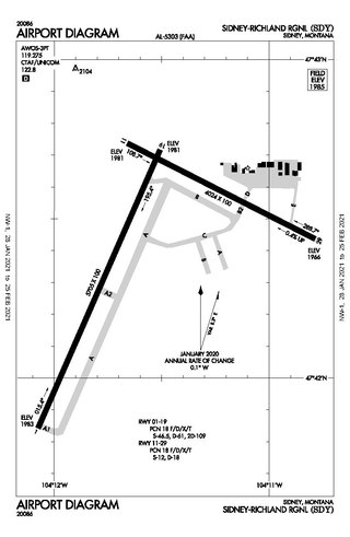
Sidney–Richland Municipal Airport is a mile west of Sidney, in Richland County, Montana, United States. The airport is served by one airline, subsidized by the federal government's Essential Air Service program at a cost of $3,777,579.

L. M. Clayton Airport is a public airport three miles east of Wolf Point, in Roosevelt County, Montana, United States. The airport is served by one airline, subsidized by the Essential Air Service program. Reportedly, it is the smallest airport in the 48 contiguous states with scheduled air service.

<span class="mw-page-title-main">Delta County Airport</span> Airport in Michigan, U.S.

Delta County Airport is a county-owned public-use airport located two nautical miles southwest of the central business district of Escanaba, a city in Delta County, Michigan, United States. It offers limited commercial service, which is subsidized by the Essential Air Service program.

Gogebic–Iron County Airport is a county-owned public-use airport located seven nautical miles (13 km) northeast of the central business district of Ironwood, a city in Gogebic County, Michigan, United States. It is mostly used for general aviation, but it also offers scheduled passenger service which is subsidized by the Essential Air Service program.

Manistee County Blacker Airport is a public use airport located three nautical miles (6 km) northeast of the central business district of Manistee, a city in Manistee County, Michigan, United States. It is owned by the Manistee County Blacker Airport Authority and is mostly used for general aviation.

<span class="mw-page-title-main">Norfolk Regional Airport</span> Airport

Norfolk Regional Airport is four miles southwest of Norfolk, in Madison County, Nebraska. The airport is named for Karl Stefan, a local newspaper editor and radio announcer who served several terms in the United States Congress. Until March 2011 it was known as Karl Stefan Memorial Airport. The FAA's National Plan of Integrated Airport Systems for 2011–2015 categorized it as a general aviation facility.

References

  1. 1 2 3 4 FAA Airport Form 5010 for DIK PDF . Federal Aviation Administration. effective October 7, 2021.
  2. Dickinson Theodore Roosevelt Regional Airport, official website
  3. 1 2 "Dickinson Airport Statistics". www.transtats.bts.gov. Retrieved May 30, 2022.
  4. Kessler, Abby (October 19, 2015). "Delta Airlines to suspend jet service to Dickinson". Grand Forks Herald. Grand Forks Herald and Forum Communications Company. Archived from the original on February 1, 2019. Retrieved July 15, 2016.
  5. "NPIAS Report 2019-2023 Appendix A" (PDF). Federal Aviation Administration . October 3, 2020. Retrieved October 23, 2021.
  6. "U.S. Transportation Secretary Elaine L. Chao Announces Over $1 Billion in Grants to 439 Airports in 50 States". April 30, 2020. Retrieved May 5, 2020.
  7. "Airport Grants Announced on April 30, 2020" (PDF). Retrieved May 4, 2020.
  8. "Airport ready for 2019 runway project". The Dickinson Press. Retrieved June 15, 2020.(subscription required)
  9. "United Airlines Route Map". United Airlines. Retrieved February 22, 2020.
  10. "FlightAware Encore Air Cargo 1541". Archived from the original on February 22, 2020. Retrieved February 22, 2020.{{cite web}}: CS1 maint: unfit URL (link)
  11. "FlightAware FedEx Feeder 7555". Archived from the original on February 22, 2020. Retrieved February 22, 2020.{{cite web}}: CS1 maint: unfit URL (link)

Other sources

Passengers boarding a United Express EMB-145 for a flight to Denver Dickinson Theodore Roosevelt Regional Airport passengers boarding United Express EMB-145.jpg
Passengers boarding a United Express EMB-145 for a flight to Denver