
The Line of Actual Control (LAC), in the context of the Sino-Indian border dispute, is a notional demarcation line that separates Indian-controlled territory from Chinese-controlled territory. The concept was introduced by Chinese premier Zhou Enlai in a 1959 letter to Jawaharlal Nehru as the "line up to which each side exercises actual control", but rejected by Nehru as being incoherent. Subsequently, the term came to refer to the line formed after the 1962 Sino-Indian War.

Ladakh is an administrative territory of India that has been under its control since 1947. The geographical region of Ladakh union territory is the highest altitude plateau region in India, incorporating parts of the Himalayan and Karakoram mountain ranges and the upper Indus River and valley.

Tourism is one of the economic contributors to the union territory of Ladakh in Northern India. This union territory is located between the Karakoram mountain range to the north and the Himalayas to the south, and is situated at a height of 11,400 ft. Ladakh is composed of Leh and Kargil districts. The region contains prominent Buddhist sites and has an ecotourism industry.

Rajnath Singh is an Indian politician and lecturer, and the Defence Minister of India since 2019. He was also the Deputy Leader of the House, Lok Sabha from 2019 to 2024. He was the President of the Bharatiya Janata Party from 2005 to 2009 and again from 2013 to 2014. He is a veteran leader of the BJP who started his career as a swayamsevak of the Rashtriya Swayamsevak Sangh.
The Sino–Indian border dispute is an ongoing territorial dispute over the sovereignty of two relatively large, and several smaller, separated pieces of territory between China and India. The territorial disputes between the two countries result from the historical consequences of colonialism in Asia and the lack of clear historical boundary demarcations.
Demchok (Tibetan: བདེ་མཆོག, Wylie: bde mchog, THL: dem chok, ZYPY: dêmqog), is a Chinese-administered village in the Zhaxigang Township, Ngari Prefecture in the Tibet Autonomous Region of China. India disputes the status and claims it as part of the Demchok sector that it regards as part of Ladakh.
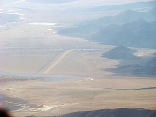
Fukche Advanced Landing Ground is an airfield in the Demchok sector of the union territory of Ladakh, India. It was built shortly before the 1962 Sino-Indian War and was revived in 2008. It is located adjacent to Koyul, 34 km northwest of Demchok.
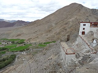
Nyoma is a principal village of southern Ladakh in India, the headquarters of an eponymous subdivision, tehsil, community development block and Indian Air Force Base in the Leh district. It is located on the bank of the Indus river after its 90-degree bend near Dungti east of Nyoma and before the valley narrows to a gorge near Mahe northwest of Nyoma. The Nyoma tehsil and subdivision cover all of southern Ladakh, including the Rupshu plains south of Nyoma, the Indus valley of Skakjung north of Nyoma, and the Hanle valley. Nyoma gompa, a Buddhist monastery, is located on the hill slope north of the village.
The Galwan River flows from the disputed Aksai Chin area administered by China to the Union Territory of Ladakh, India. It originates near the caravan campsite Samzungling on the eastern side of the Karakoram range and flows west to join the Shyok River. The point of confluence is 102 km south of Daulat Beg Oldi. Shyok River itself is a tributary of the Indus River, making Galwan a part of the Indus River system.

Demchok , previously called New Demchok, and called Parigas by the Chinese, is a village and military encampment in the Indian-administered Demchok sector, that is disputed between India and China. It is administered as part of the Nyoma tehsil in the Leh district of Ladakh by India, and claimed by China as part of the Tibet Autonomous Region.
The Charding Nullah, traditionally known as the Lhari stream and called Demchok River by China, is a small river that originates near the Charding La pass that is also on the border between the two countries and flows northeast to join the Indus River near a peak called "Demchok Karpo" or "Lhari Karpo". There are villages on both sides of the mouth of the river called by the same name "Demchok", which is presumed to have been a single village originally, and has gotten split into two due to geopolitcal reasons. The river serves as the de facto border between China and India in the southern part of the Demchok sector.
The Demchok sector is a disputed area named after the villages of Demchok in Ladakh and Demchok in Tibet, situated near the confluence of the Charding Nullah and Indus River. It is a part of the greater Sino-Indian border dispute between China and India. Both China and India claim the disputed region, with a Line of Actual Control between the two nations situated along the Charding Nullah.

Beginning on 5 May 2020, Chinese and Indian troops engaged in aggressive melee, face-offs, and skirmishes at locations along the Sino-Indian border, including near the disputed Pangong Lake in Ladakh and the Tibet Autonomous Region, and near the border between Sikkim and the Tibet Autonomous Region. Additional clashes also took place at locations in eastern Ladakh along the Line of Actual Control (LAC).
Demchok, was described by a British boundary commission in 1847 as a village lying on the border between the Kingdom of Ladakh and the Tibet. It was a "hamlet of half a dozen huts and tents", divided into two parts by a rivulet which formed the boundary between the two states. The rivulet, a tributary of the Indus River variously called the Demchok River, Charding Nullah, or the Lhari stream, was set as the boundary between Ladakh and Tibet in the 1684 Treaty of Tingmosgang. By 1904–05, the Tibetan side of the hamlet was said to have had 8 to 9 huts of zamindars (landholders), while the Ladakhi side had two. The area of the former Demchok now straddles the Line of Actual Control, the effective border of the People's Republic of China's Tibet Autonomous Region and the Republic of India's Ladakh Union Territory.
In early May 2020, troops of the People's Liberation Army and Indian Army engaged in melee at locations along the notional Line of Actual Control (LAC), the disputed boundary between China and India. It escalated on 15/16 June 2020 resulting in deaths on both sides. Indian sources reported the deaths of 20 Indian soldiers and casualties of at least 45 Chinese soldiers. China reported 4 deaths. On 7 September, for the first time in 45 years, shots were fired along the LAC, with both sides blaming each other for the firing. Indian media also reported that Indian troops fired warning shots at the PLA on 30 August.
The Depsang Bulge or Burtsa Bulge is a 900-square-kilometre area of mountain terrain in the disputed Aksai Chin region, which was conceded to India by China in 1960, but has remained under Chinese occupation since the 1962 Sino-Indian War. The area is immediately to the south of the Depsang Plains and encloses the basin of the Burtsa Nala, a stream originating in the Aksai Chin region and flowing west to merge with the Depsang Nala near the village of Burtsa in Ladakh, eventually draining into the Shyok River. The area is perceived to be of strategic importance to both the countries, sandwiched by strategic roads linking border outposts. Since 2013, China has made attempts to push the Line of Actual Control further west into Indian territory, threatening India's strategic road.
The Border Peace and Tranquility Agreement is an agreement signed by China and India in September 1993, agreeing to maintain the status quo on their mutual border pending an eventual boundary settlement. The Agreement on Military Confidence Building Measures, 1996, pursuant to the 1993 agreement, incrementally details the military confidence building measures to be implemented that would ensure no-war. The Protocol for the Implementation of Military Confidence Building Measures, 2005 further discussed modalities to implement the confidence building measures.

The Agreement between India and China on Border Defence Cooperation (BDCA) covers border stability and security, information asymmetry, smuggling, socio-economic reconstruction, environment and disease transmission along the line of actual control. It is an incremental addition to the previous border agreements related to the Sino-Indian border dispute.
Jianan Pass is a mountain pass in the eastern Karakoram Range near the Chang Chenmo Valley. The Line of Actual Control (LAC) between India and China runs through the pass dividing the Indian-administered Ladakh and Chinese-administered Aksai Chin. The pass lies on the watershed between Kugrang and Galwan river basins. The Changlung river basin is also immediately to the east of the pass. While China uses the name "Jianan Daban" for the pass, India refers to it as Patrol Point 15 (PP-15) for border security purposes. The term "Hot Springs" has also been used by Indian media through misapplication of terminology.

The Yangtse clash of 9 December 2022 occurred at night between the troops of the Indian Army and the Chinese People's Liberation Army (PLA) along their mutually contested Line of Actual Control (LAC) in the Yangtse region of Tawang in the Indian state of Arunachal Pradesh. Violent clashes ensued after the two armies confronted each other with nail-studded clubs and other melee weapons near positions on a border ridgeline in close vicinity of the revered Buddhist site of Chumi Gyatse Falls. The border incident marked the most serious clash between the two armies along their undemarcated frontier since the Galwan Valley clash in June 2020, which had led to the deaths of 20 Indian soldiers and an unknown number of dead on the Chinese side.
