Excavations in 1905–1907 produced hundreds of Roman-period pot sherds of the 3rd and 4th centuries CE, many repaired with iron clamps. Animal bones were found too, some made into tools and one into a musical instrument. The most important economic activity, however, appears to have been iron working, smithing and perhaps smelting.
Despite the mainly Roman finds, the origins of the settlement may well go back into the Iron Age and it was probably a small farming community. From excavation, it seems that the round structures were probably houses and the rectangular ones barns or workshops.
For a Roman site, much remains visible above ground, including the enclosing wall and the foundations of many buildings, many of them with substantial and well made foundations constructed from the local limestone. The outer protective wall is almost intact although much reduced in height.
Din Lligwy is situated on a low hill with good views over Anglesey and a reliable source of fresh water nearby. The hill is now overgrown with sycamore and ash but it is probable that when it was occupied, the village would have had uninterrupted views all around.
Sutton Hoo is the site of two early medieval cemeteries dating from the 6th to 7th centuries near the English town of Woodbridge. Archaeologists have been excavating the area since 1938, when a previously undisturbed ship burial containing a wealth of Anglo-Saxon artefacts was discovered. The site is important in establishing the history of the Anglo-Saxon kingdom of East Anglia as well as illuminating the Anglo-Saxons during a period which lacks historical documentation.
A hillfort is a type of earthwork used as a fortified refuge or defended settlement, located to exploit a rise in elevation for defensive advantage. They are typically European and of the Bronze Age or Iron Age. Some were used in the post-Roman period. The fortification usually follows the contours of a hill and consists of one or more lines of earthworks, with stockades or defensive walls, and external ditches. Hillforts developed in the Late Bronze and Early Iron Age, roughly the start of the first millennium BC, and were used in many Celtic areas of central and western Europe until the Roman conquest.
Bryn Celli DduWelsh pronunciation: [brʌn keːɬi ðɨː] is a prehistoric site on the Welsh island of Anglesey located near Llanddaniel Fab. Its name means 'the mound in the dark grove'. It was archaeologically excavated between 1928 and 1929. Visitors can get inside the mound through a stone passage to the burial chamber, and it is the centrepiece of a major Neolithic Scheduled Monument in the care of Cadw. The presence of a mysterious pillar within the burial chamber, the reproduction of the 'Pattern Stone', carved with sinuous serpentine designs, and the fact that the site was once a henge with a stone circle, and may have been used to plot the date of the summer solstice have all attracted much interest.
Knowth is a Neolithic passage grave and an ancient monument of the World Heritage Site of Brú na Bóinne located 8.4 km west of Drogheda in Ireland's valley of the River Boyne. It is the largest passage grave of the Brú na Bóinne complex. It consists of a large mound and 17 smaller satellite tombs. The mound is about 12 metres (40 ft) high and 67 metres (220 ft) in diameter, covering roughly a hectare. It contains two passages placed along an east-west line and is encircled by 127 kerbstones, of which three are missing, and four badly damaged.
Moelfre is a village, a community and, until 2012, an electoral ward on the north-east coast of the Isle of Anglesey in Wales. The community area covers the village and harbour, and several smaller, dispersed settlements. It includes six scheduled Iron Age hut groups and many other sites of archaeological interest. The harbour was formerly a local fishing port; a lifeboat station has been based here since 1854. Among many shipwrecks off the coast was that of the Royal Charter in 1859. Near the modernised lifeboat station is the RNLI Seawatch Centre. The coastline includes a rocky headland north of the village and a large sandy beach at Lligwy Bay, both traversed by the Anglesey Coastal Path. The 2011 census measured the village population as 710. It was estimated at 614 in 2019.
Stanwick Iron Age Fortifications, a huge Iron Age hill fort, sometimes but not always considered an oppidum, comprising over 9 kilometres (5.6 mi) of ditches and ramparts enclosing approximately 300 hectares of land, are situated in Richmondshire, North Yorkshire, England. Whether Stanwick was the stronghold of Venutius or Cartimandua, or perhaps of them both for a brief time before their acrimonious split some time after 51 AD, it is certain that this settlement was one of the most important in Brigantia, the Brigantes kingdom during the early stages of the Roman occupation of Britain. The site is a scheduled monument.
Lligwy Bay is a bay of the Welsh island of Anglesey.
Barclodiad y Gawres is a Neolithic burial chamber between Rhosneigr and Aberffraw on the south-western coast of the island of Anglesey in North Wales. It is an example of a cruciform passage grave, a notable feature being its decorated stones. Similar graves and marks exist across the Irish Sea in the Boyne Valley.
Llugwy may refer to a number of places and archaeological sites in Wales:
Llys Rhosyr, also known as "Cae Llys", is an archaeological site near Newborough in Anglesey; the ruins of a pre-Edwardian commotal court. The Welsh word llys originally referred to an enclosed open-air space but gradually took on the meaning of a place where legal proceedings took place and was gradually extended to refer to royal "courts".
The Holyhead Mountain Hut Circles, also known as 'Tŷ Mawr Hut Circles', Cytiau'r Gwyddelod or the 'Irishmen's Huts', are the remains of a group of Celtic Iron Age huts near Trearddur on Holy Island, Anglesey, Wales. The site is under the care of Cadw and can be visited all year round. The construction of these huts are very similar to those at Din Lligwy, having thick stone walls.
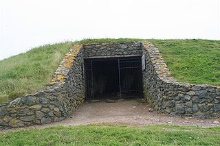
Lligwy Burial Chamber is a Neolithic burial chamber in Lligwy, near the east coast of Anglesey, Wales, United Kingdom. It consists of a circle of upright stones, made into a low chamber by a very large roof slab estimated at 25 tonnes. Excavation in 1909 found the remains of some 15 to 30 people, and pottery suggesting a late Neolithic date. Close to the village of Moelfre, the site is within a few metres of the road, where there is room to leave a single car for short periods.
Capel Lligwy is a ruined chapel near Rhos Lligwy in Anglesey, north Wales, dating back to the first half of the 12th century. The chapel's original purpose is unknown, but it might have been used as a memorial chapel or in connection with a local royal court, or as a chapel of ease in a large parish with a growing population. It was used for a time until the early 18th century as a private place of worship for a nearby house, then later fell into disrepair. The walls still remain, with some traces of render on them internally, but there is no roof.
Din Dryfol is a Neolithic burial chamber on Anglesey, in Wales. It is a scheduled monument and is maintained by Cadw. The monument is near Bethel. Three phases of use have been identified, all dating from the Neolithic period.
Folkestone Roman Villa, also referred to as the East Bay Site, is a villa built during the Roman Occupation of Britain, and is located in East Wear Bay near the port town of Folkestone, in Kent, England. The villa is situated on a cliff top overlooking the English Channel, with views of the French coast at Boulogne on a clear day. It is situated near the start of the North Downs Trackway, and the area has been inhabited for thousands of years, with archeological finds in the area and at the villa site dating back to the mesolithic and neolithic ages. The villa was built around A. D. 75, and was almost certainly built within the confines of a preexisting Iron Age settlement.
Parciau hill fort is a hill fort on the Welsh island of Anglesey. It stands on the summit of Bryn Ddiôl, whose name means "trackless hill".
Trefignath is a Neolithic burial chamber near Trearddur, south of Holyhead on Holy Island, off Anglesey in Wales. In its most complete form it included a large cairn covering three stone tombs, set on a small knoll. It was excavated between 1977 and 1979, revealing several phases of occupation with three separate burial chambers built in succession. It is a scheduled ancient monument, maintained by Cadw.
Tel Yokneam, also spelled Yoqne'am or Jokneam, is an archaeological site located in the northern part of the modern city of Yokneam Illit. It was known in Arabic by a variant name, Tell Qamun, believed to be a corruption of the Hebrew name. The site is an elevated mound, or tel, spanning around 40 dunams and rising steeply to a height of 60 meters (200 ft). With a few brief interruptions, Yokneam was occupied for 4,000 years, from the Middle Bronze Age to the Ottoman Empire.
Tel Mevorakh is a small mound situated on the southern bank of Nahal Taninim in Israel. The tel does not exceed 1 dunam but rises to a height of 15 metres (50 ft) above its surrounding plain. The site contains some fifteen layers of human settlement, which accumulate to a height of 8 meters, meaning the natural hill does not exceed a height of 7 meters. It is located on the border between the wide Sharon Plain and the coast of Mount Carmel.
This page is based on this Wikipedia article Text is available under the CC BY-SA 4.0 license; additional terms may apply. Images, videos and audio are available under their respective licenses.