Dishergarh

Last updated

Dishergarh
Neighbourhood in Asansol
West Bengal location map.svg
Red pog.svg
Dishergarh
Location in West Bengal, India
Coordinates: 23°41′N86°51′E / 23.69°N 86.85°E / 23.69; 86.85
CountryFlag of India.svg  India
State West Bengal
District Paschim Bardhaman
City Asansol
Municipal Corporation Asansol Municipal Corporation
AMC Wards No.s103,104,105
Languages*
  Official Bengali, Hindi, English
Time zone UTC+5:30 (IST)
PIN
713333
Telephone code0341
Vehicle registration WB-38, WB-44, WB-37(Commercial)
Lok Sabha constituency Asansol
Vidhan Sabha constituency Kulti
Website paschimbardhaman.co.in

Dishergarh is a neighbourhood in Asansol of Paschim Bardhaman district in the Indian state of West Bengal. It is governed by Asansol Municipal Corporation. [1] It is situated at the border of the Purulia district and Paschim Bardhaman district in West Bengal. The State Highway 5 (West Bengal) (SH5) passes through Dishergarh. The neighbourhood is located on the banks of Damodar River.

Contents

History

According to popular belief, the name "Dishergarh" originated from "Shergarh" i.e. "The Fort of Sher Afghan", the Jagirdar of Burdwan. The British referral to the place as "The Shergarh" mutated into "Dishergarh". Probably, this fort was a holiday resort of Sher Afghan who was the first husband of Mehr- un - nissa (later Noor Jehan after marrying Jehangir). It is said that Jehangir got Sher Afghan killed to possess Mehr - un - nissa whose renowned beauty he was obsessed with. Although, there is no direct evidence to prove that Sher Afghan used to visit Shergarh with Mehr - un - nissa, some local names nearby the area point its link towards royalty. For example, Hatinal (meaning place for elephants), Mahotdih (meaning place for Mahots), Sanctoria (meaning place for shell work). Remnants of a semicircular mote, ideal in design as a defensive canal, can be found even today, very prominent at Bhanga Pool area on the way to Barakar and also at Sodepur.

During the British rule, Dishergarh (Shergarh) was one of their important locations in terms of commerce. The colony had one of the oldest European Clubs and tennis courts of the area, the remnants of which are visible up to this day.

Geography

Dishergarh
Invisible Square.svg
Mapscaleline.svg
5km
3miles
Red pog.svg
Ajay River
Maithon Dam
Reservoir
River
Barakar
River
Damodar
Chittaranjan
Locomotive
Works
IISCO
Steel Plant
Sitarampur
NV
Invisible Square.svg
Barakar
N
Invisible Square.svg
Rupnarayanpur
P
Invisible Square.svg
Kalla
N
Invisible Square.svg
Dishergarh
N
Kulti
N
Invisible Square.svg
Neamatpur
N
Invisible Square.svg
Burnpur
N
Invisible Square.svg
Asansol
MC
Invisible Square.svg
ECL Sodepur
Area Office
Invisible Square.svg
ECL Salanpur
Area Office
Invisible Square.svg
Kalyaneshwari
Temple
T
Invisible Square.svg
Barabani
P
Invisible Square.svg
Salanpur
P
Invisible Square.svg
Charanpur
OG
Invisible Square.svg
Panuria
CT
Invisible Square.svg
Majiara
CT
Invisible Square.svg
Bhanowara
CT
Invisible Square.svg
Domohani
CT
Invisible Square.svg
Pangachhiya
CT
Invisible Square.svg
Hindustan Cables Township
CT
Invisible Square.svg
Cities, towns and ECL Areas in the western portion of Asansol Sadar subdivision in Paschim Bardhaman district
MC: municipal corporation, P: rural administrative centre, CT: census town, N: neighbourhood, OG: out growth, T: temple
Owing to space constraints in the small map, the actual locations in a larger map may vary slightly

Location

Asansol is composed of undulating laterite region. The Damodar River flows through this area. For ages, the area was heavily forested and infested with plunderers and marauders. The discovery of coal led to industrialisation of the area and most of the forests have been cleared.

The area forms the lowest step of the Chota Nagpur Plateau. The general scenario is undulating land with scattered hills. It is located North of Damodar River.

Dishergarh is at the confluence of the Damodar River and Barakar River with Khudia river as the 'falgu nadi', thus making it a Triveni Sangam, an auspicious happening for Hindus.

Urbanisation

As per the 2011 census, 83.33% of the population of Asansol Sadar subdivision was urban and 16.67% was rural. [2] Asansol Sadar subdivision has 26 (+1 partly) Census Towns. (partly presented in the map alongside; all places marked on the map are linked in the full-screen map).

Asansol Municipal Corporation

According to the Kolkata Gazette notification of 3 June 2015, the municipal areas of Kulti, Raniganj and Jamuria were included within the jurisdiction of Asansol Municipal Corporation. [3]

*For language details see Salanpur (community development block)#Language and religion

Economy

It is an important coal mining area of Eastern Coalfields Ltd., a subsidiary of Coal India Limited. This area of Paschim Bardhaman district is linked with Par Beliya under Neturia Police Station in Purulia District with a bridge across the Damodar River.

The Headquarters of Eastern Coalfields Limited (ECL), A Subsidiary of Coal India Limited is situated in Barakar Road, Sanctoria. There is a Training Institute for Coal India employees.

The Dishergarh Power Supply (DPS) Company also has its Central office at Jhalbagan, Sanctoria with the main power plant being located at Chinakuri.

The place basically consists of a straight road which bifurcates at the Dishegarh Post Office More, one towards Asansol via Neamatpur and the other towards Barakar . The place also consists of the Eastern Coalfields Ltd. office at Sanctoria, Central Office of Dishergarh Power Supply Company, some commercial establishments and residential areas thereafter.

Culture

Chhinnamasta Temple

There is Chhinnamasta Temple on the banks of the Damodar River. Melas are held every year in makuri saptami to ekadashi the Temple surroundings. The local people call this Mela as Chhinnamastar Mela.

Sher Shah Baba's Mazar

There is also a pilgrimage centre for Muslim community known to the local people as Sher Shah Baba ka Mazar. Melas are also held generally during the months of March and April. The local language of this area is Hindi and Bengali.

Other temples: Babubasa Kali Temple, Hanuman Temple

Purbachal park

There is a purbachal park on the banks of the Damodar River.

Educational institutions

Dishergarh A.C. Institution, SD Girls High School, Sanctoria High School are the main schools in Dishergarh. However the medium of Instruction in these schools is through Bengali language. However, there are many English Medium Schools nearby Dishergarh

Some Colleges near Dishergarh

Healthcare

The 250-bed Sanctoria Hospital of Eastern Coalfields is located at Barakar Road, Sanctoria, Dishergarh. [4]

A new Health Centre will be started shortly under Asansol Municipal Corporation by Councillors of 104 & 105 No.s Wards.

Medical facilities (dispensaries) in the Sodepur Area of ECL are available at Chinakuri I & II (PO Sundarchak), Chinakuri Mine III (PO Radhanagar), Parbelia (PO Neturia), Narsamuda (PO Mithani), Bejdih (PO Kulti), Mithani (PO Mithani), Patmohna (PO Patmohna), Sodepur 9/10 (PO Sundarchak), Mouthdih (PO Sundarchak), Dhemo Main (PO Main Dhemo). [5]

Tourist attraction

Nearly 300 acres (1.2 km2) of land with waterbody is now an attraction for the citizens of Asansol, with a mini-zoo and a children's park. During winter, the lake supports hundreds of migratory birds. An anglers' club also exists at the Ecological Park. Asansol police is in a process to develop the area in association with ECL, SAIL-ISP and ADDA.

Transport

Regular Mini Bus services are available to Asansol City Bus Stand (15 km from Dishergarh) and Barakar (5 km).

The State Highway 5 (West Bengal) passes through Dishergarh. Long distance private buses running between Asansol and Purulia (75 km from Dishergarh) have a stoppage at Dishergarh. One can also go to Ranchi (190 km from Dishergarh) or Jamshedpur as direct bus service is available but their count is very small.

Dishergarh has a direct bus connectivity with Kolkata (220 km from Dishergarh) by many buses run by the South Bengal State Transport Corporation from Purulia to Kolkata via Asansol and Durgapur. These buses provide a halt here. It takes only 5 - 5.5 hours by these buses to reach Kolkata. Also many new bus routes towards Purulia & Ranchi is being opened by South Bengal State Transport Corporation & other operators from various parts of the West Bengal which directly pass through Dishergarh and provide a halt here.

But there is no railway connectivity to Dishergarh. One has to go to Asansol Junction, Barakar, Kulti, Burnpur, Sitarampur Junction or Madhukunda in Purulia District stations for catching a train.

See also

Related Research Articles

<span class="mw-page-title-main">Asansol</span> Industrial city in West Bengal, India

Asansol is a city in the Indian state of West Bengal. It is the second largest and one of the most populated cities of West Bengal. It is the 39th largest urban agglomeration in India by population. Asansol is the district headquarters of Paschim Bardhaman district. According to a 2010 report released by the International Institute for Environment and Development, a UK-based policy research non-governmental body, Asansol was ranked 11th among Indian cities and 42nd in the world in its list of 100 fastest-growing cities. Asansol is classed as a Y-category city for calculation of HRA for public servants making it a "Tier-II" city.

<span class="mw-page-title-main">Barakar</span> Neighbourhood in Asansol in Paschim Bardhaman, West Bengal, India

Barakar is a neighbourhood in Asansol, Paschim Bardhaman district in the Indian state of West Bengal. It is governed by the Asansol Municipal Corporation It is situated at the border of the states of Jharkhand and West Bengal. The Grand Trunk Road passes through Barakar. The neighbourhood is located on the banks of the river Barakar.

<span class="mw-page-title-main">Neamatpur</span> Neighbourhood in Asansol in Paschim Bardhaman, West Bengal, India

Neamatpur is a neighbourhood in Asansol of Paschim Bardhaman district in the Indian state of West Bengal. It is governed by Asansol Municipal Corporation.

Bhanowara is a census town in the Barabani CD block in the Asansol Sadar subdivision of the Paschim Bardhaman district in the state of West Bengal, India.

Kulti is a neighbourhood in Asansol. Asansol is located in Paschim Bardhaman district in the Indian state of West Bengal. It is governed by Asansol Municipal Corporation.

Maithon is a census town in Nirsa CD Block in Dhanbad Sadar subdivision of Dhanbad district in the Indian state of Jharkhand. It is situated on the banks of river Barakar

Panchgachia is a census town in the Barabani CD block in the Asansol Sadar subdivision of the Paschim Bardhaman district in the Indian state of West Bengal.

Parbelia is a census town in the Neturia CD block in the Raghunathpur subdivision of the Purulia district in the Indian state of West Bengal.

Sitarampur is a neighbourhood in Asansol, West Bengal. It is governed by the Asansol Municipal Corporation, and was one of the early hubs of coal mining activity.

<span class="mw-page-title-main">Barakar River</span> River in Jharkhand and West Bengal

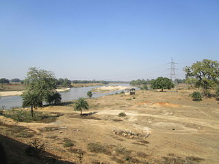
The Barakar River is the main tributary of the Damodar River in eastern India. Originating near Padma in Hazaribagh district of Jharkhand it flows for 225 kilometres (140 mi) across the northern part of the Chota Nagpur Plateau, mostly in a west to east direction, before joining the Damodar near Dishergarh in Asansol, Bardhaman district of West Bengal. It has a catchment area of 6,159 square kilometres (2,378 sq mi). Its main tributaries Barsoti and Usri flow in from the south and north, respectively. Apart from the two main tributaries, some 15 medium or small streams also join it.

<span class="mw-page-title-main">Asansol Sadar subdivision</span> Subdivision in West Bengal, India

Asansol Sadar subdivision is an administrative subdivision of the Paschim Bardhaman district in the state of West Bengal, India.

<span class="mw-page-title-main">Kalyaneshwari Temple</span> Hindu temple in West Bengal, India

Kalyaneshwari temple at Kalyaneshwari in Asansol Sadar subdivision of Paschim Bardhaman district in the Indian state of West Bengal.

Barabani is a village, in the Barabani CD block in the Asansol Sadar subdivision of the Paschim Bardhaman district in the state of West Bengal, India.

Salanpur is a village, in the Salanpur CD block in the Asansol Sadar subdivision of the Paschim Bardhaman district in the state of West Bengal, India.

Charanpur is a village in the Paschim Bardhaman district of West Bengal, India, about 9 kilometres (5.6 mi) from the industrial town of Asansol.

Domohani is a census town in the Barabani CD block in the Asansol Sadar subdivision of the Paschim Bardhaman district in the state of West Bengal, India.

Sodepur Area is one of the 14 operational areas of Eastern Coalfields Limited located mainly in Asansol subdivision of Paschim Bardhaman district and partly of Raghunathpur subdivision in Purulia district, both in the state of West Bengal, India.

Salanpur Area is one of the 14 operational areas of Eastern Coalfields Limited located in Asansol subdivision of Paschim Bardhaman district, in the state of West Bengal, India.

Panuria is a census town in the Barabani CD block in the Asansol Sadar subdivision of the Paschim Bardhaman district in the Indian state of West Bengal.

Kalla is a neighbourhood in Asansol of Paschim Bardhaman district in the Indian state of West Bengal. It is governed by Asansol Municipal Corporation

References

  1. "Archived copy" (PDF). Archived from the original (PDF) on 12 March 2017. Retrieved 9 March 2017.{{cite web}}: CS1 maint: archived copy as title (link)
  2. "District Statistical Handbook 2014 Burdwan". Table 2.2, 2.4(a). Department of Statistics and Programme Implementation, Government of West Bengal. Retrieved 4 September 2018.
  3. "The Kolkata Gazette" (PDF). Notification No. 335/MA/O/C-4/1M-36/2014 dated 3 June 2015. Department of Municipal Affairs, Government of West Bengal. Archived from the original (PDF) on 12 March 2017. Retrieved 9 March 2017.
  4. "Eastern Coalfields Limited's Hospitals" (PDF). ECL. Archived from the original (PDF) on 26 April 2017. Retrieved 23 April 2017.
  5. "Details of medical facilities in CIL and its subsidiaries". ECL. CIL. Retrieved 15 May 2020.[ permanent dead link ]