Dishman, Washington

Last updated
Dishman, Washington
Locale
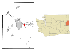
Spokane County Washington Incorporated and Unincorporated areas Dishman Highlighted.svg
Location of Dishman, Washington
Coordinates: 47°39′24″N117°16′40″W / 47.65667°N 117.27778°W / 47.65667; -117.27778
CountryUnited States
State Washington
County Spokane
Area
  Total3.4 sq mi (8.7 km2)
  Land3.4 sq mi (8.7 km2)
  Water0.0 sq mi (0.0 km2)
Elevation
1,985 ft (605 m)
Population
 (2000)
  Total10,031
  Density2,969.7/sq mi (1,146.6/km2)
Time zone UTC-8 (Pacific (PST))
  Summer (DST) UTC-7 (PDT)
FIPS code 53-17985 [1]
GNIS feature ID1512151 [2]

Dishman is a locale and former census-designated place (CDP) in Spokane County, Washington, United States. Founded by Addison T. Dishman (II), who operated a nearby rock quarry in 1889, [3] its population was 10,031 at the 2000 census. Dishman has been part of Spokane Valley since 2003.

Contents

Geography

Dishman is located at 47°39′24″N117°16′40″W / 47.65667°N 117.27778°W / 47.65667; -117.27778 (47.656544, -117.277809). [4]

According to the United States Census Bureau, the CDP had a total area of 3.4 square miles (8.8 km2), all of it land.

Demographics

As of the census [1] of 2000, there were 10,031 people, 4,151 households, and 2,565 families residing in the CDP. The population density was 2,969.7 per square mile (1,146.6/km2). There were 4,408 housing units at an average density of 1,305.0 per square mile (503.9/km2). The racial makeup of the CDP was 92.93% White, 0.81% African American, 1.81% Native American, 1.33% Asian, 0.03% Pacific Islander, 1.10% from other races, and 1.99% from two or more races. Hispanic or Latino of any race were 2.89% of the population.

There were 4,151 households, out of which 29.6% had children under the age of 18 living with them, 44.5% were married couples living together, 12.4% had a female householder with no husband present, and 38.2% were non-families. 31.2% of all households were made up of individuals, and 10.4% had someone living alone who was 65 years of age or older. The average household size was 2.36 and the average family size was 2.96.

In the CDP, the age distribution of the population shows 24.6% under the age of 18, 9.7% from 18 to 24, 29.3% from 25 to 44, 21.0% from 45 to 64, and 15.5% who were 65 years of age or older. The median age was 37 years. For every 100 females, there were 97.1 males. For every 100 females age 18 and over, there were 93.0 males.

The median income for a household in the CDP was $32,512, and the median income for a family was $40,085. Males had a median income of $30,929 versus $23,388 for females. The per capita income for the CDP was $16,721. About 10.4% of families and 14.2% of the population were below the poverty line, including 23.2% of those under age 18 and 8.1% of those age 65 or over.

Related Research Articles

<span class="mw-page-title-main">Trapper Creek, Alaska</span> Census-designated place in Alaska, United States

Trapper Creek is a census-designated place (CDP) in Matanuska-Susitna Borough, Alaska, United States. It is part of the Anchorage Metropolitan Area and is known as the southern gateway to Denali State Park. According to the 2020 census the population of Trapper Creek was 499.

High Point was a former census-designated place (CDP) and current unincorporated place in Palm Beach County, Florida, United States. The population was 2,191 at the 2000 census. The CDP was removed from the 2010 census.

<span class="mw-page-title-main">Spokane, Missouri</span> Census-designated place in Missouri, United States

Spokane is a census-designated place in Christian County, Missouri, United States. The population was 177 at the 2010 census. It is part of the Springfield, Missouri, Metropolitan Statistical Area.

<span class="mw-page-title-main">Redford, Texas</span> CDP in Texas, United States

Redford is a census-designated place (CDP) in Presidio County, Texas, United States. The population was 90 at the 2010 census.

<span class="mw-page-title-main">West Gate, Prince William County, Virginia</span> Unincorporated community & Former Census-designated place in Virginia, United States

West Gate is an unincorporated community and former census-designated place (CDP) in Prince William County, Virginia, United States. The population was 7,493 at the 2000 census. It contained the now-defunct Sunnybrook Golf Club.

<span class="mw-page-title-main">Banks Lake South, Washington</span> Census-designated place in Washington, United States

Banks Lake South is a census-designated place (CDP) in Grant County, Washington, United States. The population was 174 at the 2010 census.

<span class="mw-page-title-main">Airway Heights, Washington</span> City in Washington, United States

Airway Heights is a city in Spokane County, Washington, United States, just west of Spokane. The population was 10,757 at the 2020 census. The city's name was taken from its close proximity to the runways at Fairchild Air Force Base and Spokane International Airport.

<span class="mw-page-title-main">Country Homes, Washington</span> CDP in Washington, United States

Country Homes is a census-designated place (CDP) in Spokane County, Washington, United States. The population was 6,251 at the 2020 census. The campus of Whitworth University is located in Country Homes.

<span class="mw-page-title-main">Fairwood, Spokane County, Washington</span> CDP in Washington, United States

Fairwood is a census-designated place (CDP) in Spokane County, Washington, United States. The population was 10,541 at the 2020 census.

<span class="mw-page-title-main">Greenacres, Washington</span> Locale in Washington, United States

Greenacres is a locale and former census-designated place (CDP) in Spokane County, Washington, United States. The locale is almost entirely split between the city of Spokane Valley and unincorporated Spokane County, with a small portion being located within the city of Liberty Lake. Greenacres retains its own post office.

<span class="mw-page-title-main">Liberty Lake, Washington</span> City in Washington, United States

Liberty Lake is a city in Spokane County, Washington, United States located adjacent to the eponymous lake. Located just over a mile west of the Washington–Idaho border, Liberty Lake is both a suburb of Spokane, Washington and a bedroom community to Coeur d'Alene, Idaho. The population was 12,003 at the 2020 census.

<span class="mw-page-title-main">Opportunity, Washington</span> Locale in Washington, United States

Opportunity is a locale and former census-designated place in Spokane County, Washington, United States. The population was 25,065 at the 2000 census.

<span class="mw-page-title-main">Otis Orchards-East Farms, Washington</span> CDP in Washington, United States

Otis Orchards-East Farms is a census-designated place (CDP) in Spokane County, Washington, United States, near the county's border with Idaho. The population was 6,299 at the 2020 census. The CDP includes the unincorporated communities of Otis Orchards and East Farms. Otis Orchards contains the bulk of the businesses of the community.

<span class="mw-page-title-main">Trentwood, Washington</span> Locale in Washington, United States

Trentwood is a locale and former census-designated place (CDP) in Spokane County, Washington, United States, east across the Spokane River from Irwin. The population was 4,388 at the 2000 census. Trentwood joined the other unincorporated communities in the region to form the city of Spokane Valley in 2003.

<span class="mw-page-title-main">Veradale, Washington</span> Locale in Washington, United States

Veradale—originally known as Vera—is a locale and former census-designated place in Spokane County, Washington, United States. The population was 9,387 at the 2000 census. Veradale retains its own post office.

<span class="mw-page-title-main">Terrace Heights, Washington</span> CDP in Washington, United States

Terrace Heights is a census-designated place (CDP) in Yakima County, Washington, United States. The population was 6,937 at the 2010 census. It is essentially a suburb of the city of Yakima.

<span class="mw-page-title-main">Woods Landing-Jelm, Wyoming</span> CDP in Wyoming, United States

Woods Landing-Jelm is a census-designated place (CDP) in Albany County, Wyoming, United States. The population was 97 at the 2010 census.

<span class="mw-page-title-main">Lance Creek, Wyoming</span> CDP in Wyoming, United States

Lance Creek is a census-designated place (CDP) in Niobrara County, Wyoming, United States. The population was 43 at the 2010 census. Lance Creek is the namesake of the Lance Formation, a rock formation from the Late Cretaceous that has yielded fossils from a diverse number of species.

<span class="mw-page-title-main">Rowley (CDP), Massachusetts</span> Census-designated place in Massachusetts, United States

Rowley is a census-designated place (CDP) in the town of Rowley in Essex County, Massachusetts, United States. The population was 1,416 at the 2010 census.

<span class="mw-page-title-main">Big Coppitt Key</span> Census-designated place in Florida, United States

Big Coppitt Key is an island in Monroe County, Florida, United States, in the lower Florida Keys. The name is said to be a derivation of the old English word "coppice", meaning thicket. According to A.D. Bache, in the notes for his coast survey conducted in 1861, this key was the location of Happy Jack's plantation in 1855.

References

  1. 1 2 "U.S. Census website". United States Census Bureau . Retrieved 2008-01-31.
  2. "US Board on Geographic Names". United States Geological Survey. 2007-10-25. Retrieved 2008-01-31.
  3. Majors, Harry M. (1975). Exploring Washington. Van Winkle Publishing Co. p. 110. ISBN   978-0-918664-00-6.
  4. "US Gazetteer files: 2010, 2000, and 1990". United States Census Bureau. 2011-02-12. Retrieved 2011-04-23.