Districts of the Belgian Congo

Last updated
Belgian Congo c. 1954 showing the main language groups in each region 1954 language map Atlas General du Congo 522.jpg
Belgian Congo c. 1954 showing the main language groups in each region

The Districts of the Belgian Congo were the primary administrative divisions when Belgium annexed the Congo Free State in 1908, each administered by a district commissioner. In 1914 they were distributed among four large provinces, with some boundary changes. In 1933 the provinces were restructured into six, again with boundary changes. The number of districts fluctuated between 12 and 26 through splits and consolidations, first rising, then falling, then rising again.

Contents

History

Districts of the Congo Free State in 1895 1895 districts Congo Free State cropped from 1950 administration map Atlas General du Congo 611.jpg
Districts of the Congo Free State in 1895

The Congo Free State was annexed by Belgium in 1908 to become the Belgian Congo. At first the structure of districts was retained. In 1910 the western districts of Banana, Boma, Matadi and Cataractes were consolidated into one administrative unit, Bas-Congo, reducing the number to twelve. [1] Parts of the Stanley Falls and Lualaba districts were combined to form Katanga in 1910, which was called a vice-government general. [2] Otherwise, the Free State districts were maintained until 28 March 1912. [3] An arrêté royal of 28 March 1912 divided the Congo into 22 districts. [3]

An arrêté royal of 28 July 1914 grouped the districts into the provinces of Congo-Kasaï, Équateur, Orientale Province and Katanga, with the objective of improving responsiveness through decentralization. [3] The consolidation had in fact started in Katanga in 1912 and Orientale in 1913, but Congo-Kasai did not formally become a vice-government until 1919. [4] Each of the new provinces was made up of several of the existing districts. The colonial administrators felt the need to assign the many diverse ethnic groups to defined territories, where before they had often been mobile. [5] The districts were divided into territories, which in turn were divided into sectors, and many chiefdoms were recognized. Several of the smallest might be combined into one sector, while the largest chiefdoms were split across sectors. [5]

The original four provinces had considerable autonomy, but in 1933 they were reorganized into six provinces, named after their capitals, and the central government assumed more control. [6] The Congo-Kasaï and Orientale provinces were both split, and some other adjustments were made to form six provinces named after their capitals; Léopoldville, Lusambo (Kasai), Costermansville (Kivu), Elisabethville (Katanga), Stanleyville (Orientale) and Coquilhatville (Équateur). The number of districts was reduced to 15, with 102 territories. Provincial boundaries remained fairly stable until after independence in 1960. [4] There continued to be frequent adjustments to district and territory boundaries, mostly to recognise sectional and tribal divisions. By 1956 there were 26 districts and 135 territories. [7]

Districts in 1910 1910 districts Belgian Congo cropped from 1950 administration map Atlas General du Congo 611.jpg
Districts in 1910

1910 districts

In 1910 there were 12 districts. Clockwise, starting from the mouth of the Congo River, they were: [8]

1912 districts

Districts in 1912 1912 districts Belgian Congo cropped from 1950 administration map Atlas General du Congo 611.jpg
Districts in 1912

In 1912 there were 22 districts. Changes were: [8]

The districts in 1912 were: [8]

Districts in 1926

1926 provinces and districts 1926 provinces Belgian Congo cropped from 1950 administration map Atlas General du Congo 611.jpg
1926 provinces and districts

By 1926 the districts had been organized into four large provinces, with some boundary changes. Apart from boundary adjustments, the district-level changes were: [8]

The new organization was¨: [8]

Districts in 1933

1933 provinces and districts 1933 provinces Belgian Congo cropped from 1950 administration map Atlas General du Congo 611.jpg
1933 provinces and districts

In 1933 the number of provinces was increased to six, while the number of districts was reduced to 16. This provincial breakdown would last until after the Republic of the Congo (Léopoldville) became independent in 1960. The new organization was: [8]

Districts in 1954

The districts in 1954 were: [9]

Post-independence

Further changes were made after the Republic of the Congo (Léopoldville) became independent. As of 2008 the provinces and districts were: [10]

See also

Related Research Articles

Politics of the Democratic Republic of the Congo

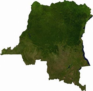
Politics of the Democratic Republic of Congo take place in a framework of a republic in transition from a civil war to a semi-presidential republic.

Orientale Province Province in Democratic Republic of the Congo

Orientale Province is one of the former provinces of the Democratic Republic of the Congo and its predecessors the Congo Free State and the Belgian Congo. It went through a series of boundary changes between 1898 and 2015, when it was divided into smaller units.

Index of Democratic Republic of the Congo–related articles Wikipedia index

Articles related to the Democratic Republic of the Congo include:

This is a history of the Kasai region in the Democratic Republic of Congo and of the political divisions which have occupied it since human settlement began.

<i>Cymothoe sangaris</i> species of insect

Cymothoe sangaris, the blood-red glider, is a species of butterfly of the family Nymphalidae. It is found in Central Africa.

Lualaba District District in Katanga, Democratic Republic of the Congo

Lualaba District was a district of the pre-2015 Katanga Province in the Democratic Republic of the Congo. The district dates back to the days of the Congo Free State and the Belgian Congo. The original Lualaba District was merged into Katanga in 1910, but in 1933 a new Lualaba District was formed within Katanga. After various significant boundary changes, in 2015 the district became the western part of the present Lualaba Province.

Ituri District District in Orientale, Democratic Republic of the Congo

Ituri District, later Kibali-Ituri District, was a district of the Belgian Congo and the Democratic Republic of the Congo. It roughly corresponded in area to the present Ituri Province.

Kasai District District in Kasaï, Democratic Republic of the Congo

Kasai District was a district of the Congo Free State, Belgian Congo and the Democratic Republic of the Congo, named after the Kasai River. It was formed around 1885 and went through several large changes in extent in the years that followed. The 1933 version of the district roughly corresponded to the former Kasai-Occidental province and the present Kasaï and Kasaï-Central provinces.

Haut-Uele District District in Orientale, Democratic Republic of the Congo

Haut-Uele District was a district of the Belgian Congo and the Democratic Republic of the Congo. It was formed from part of Uele District in 1912. It roughly corresponded in area to the present Haut-Uélé province.

Sankuru District District in Kasaï-Oriental, Democratic Republic of the Congo

Sankuru District was a district of the Belgian Congo and Democratic Republic of the Congo. It went through various changes in extent, but roughly corresponded to the modern Sankuru Province.

Bas-Uele District District in Orientale, Democratic Republic of the Congo

Bas-Uele District was a district of the Belgian Congo and the Democratic Republic of the Congo. It was formed from part of Uele District in 1912. Later it was merged back into Uele District, then split out again. There were various boundary changes. It roughly corresponded in area to the present Bas-Uélé province.

Maniema District District in Orientale, Democratic Republic of the Congo

Maniema District was a district of the Belgian Congo and the Democratic Republic of the Congo. It roughly corresponded in area to the present Maniema province.

Kivu District District in Orientale, Belgian Congo

Kivu District was a district of the Belgian Congo. It was formed from part of Stanleyville District in 1914.

Stanleyville District District in Orientale, Democratic Republic of the Congo

Stanleyville District was a district of the Belgian Congo and Democratic Republic of the Congo. It went through various changes in extent. Between 1933 and 1963 it had roughly the same extent as the current Tshopo province.

Districts of the Congo Free State

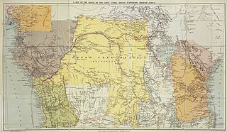
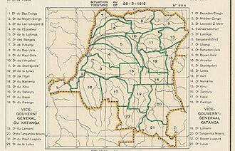
The Districts of the Congo Free State were the primary administrative divisions of the Congo Free State, the private colony of King Leopold II of Belgium from 1885 to 1908. There were various boundary changes in the period before the Congo Free State was annexed by Belgium to become the Belgian Congo.

Lomami District District in Katanga, Belgian Congo

Lomami District was a district of the Belgian Congo from 1912 to 1933, when it was dissolved. It covered very roughly the same area as the present Lomami Province and the northwest of Haut-Lomami Province.

Haut-Luapula District District in Katanga, Belgian Congo

Haut-Luapula District was a district of the Belgian Congo from 1912 to 1933, when it was dissolved. It roughly corresponded to the southern part of the present Haut-Katanga Province.

Tanganika-Moero District District in Katanga, Belgian Congo

Tanganika-Moero District was a district of the Belgian Congo from 1912 to 1933, when it was dissolved. It roughly corresponded to the present Tanganyika Province and the northern part of Haut-Katanga Province.

Tanganika District District in Katanga, Democratic Republic of the Congo

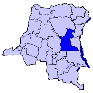
Tanganika District was a district of the pre-2015 Katanga Province in the Democratic Republic of the Congo. The district dates back to the days of the Belgian Congo. At its greatest extent it roughly corresponded to the present Tanganyika Province, with a small portion in the southwest now in Haut-Lomami Province.

Luapula-Moero District District in Katanga, Belgian Congo

Luapula-Moero District was a district of the pre-2015 Katanga Province in the Belgian Congo and Democratic Republic of the Congo. It roughly corresponded in area to the present Haut-Katanga Province.

References

  1. Lemarchand 1964, p. 62.
  2. Lemarchand 1964, pp. 62–63.
  3. 1 2 3 Lemarchand 1964, p. 63.
  4. 1 2 Lemarchand 1964, p. 64.
  5. 1 2 Bruneau 2009, p. 7.
  6. Bruneau 2009, p. 8.
  7. Lemarchand 1964, p. 65.
  8. 1 2 3 4 5 6 Atlas général du Congo.
  9. Brass 2015, p. 285.
  10. Blaes 2008.

Sources