Ubangi District

Last updated
Ubangi District
District
Democratic Republic of the Congo adm location map.svg
Red pog.svg
Ubangi District
Coordinates: 4°47′11″N19°26′31″E / 4.786431°N 19.441837°E / 4.786431; 19.441837
CountryBelgian Congo
Province Équateur
District Ubangi

Ubangi District (French : District de l'Ubangi, Dutch : District Ubangi) was a district of the Congo Free State, Belgian Congo and Democratic Republic of the Congo. It went through various significant changes in extent.

Contents

Congo Free State

A decree of 1 August 1888 divided the Congo Free State into eleven districts, of which the first five were in the lower Congo region: [1] Ubangi-Uélé District had its capital at Nouvelle Anvers. [1] In 1895 the number of the districts was increased to fifteen, including Ubangi District and Uele District. [1] An 1897 map of the Congo Free State showed Ubangi District as a long strip along the northwest border of the colony, on the left bank of the Ubangi River, which defined the border down to its confluence with the Congo River. Bangalas District was to the south and Uelé District was to the east. [2]

In 1892 King Leopold II of Belgium declared that the Ubangi River basin and other parts of the Congo Free Statey were private domains of the state, although exploitation of rubber in parts of these domains by specific companies was allowed. [3] Reports of missionaries show that working conditions imposed on the populations by the rubber companies was harsh and almost inhuman. Lieutenant Louis Royaux was appointed to the Ubangi District in April 1896, responsible for exploiting rubber in the district. He reached Ubangi in April 1897, and first had to reoccupy the Imesse post in south Ubangi, and build a station on the site of the former village of Libenge, which would become the district capital. Royaux reached Banzyville territory in December 1898, but before starting rubber production had to recruit as many men as possible to fight the Batetela in Uele, who had been in rebellion since 1897. [3]

Royaux spent 1900 teaching each village about rubber harvesting, despite the insistence of the Ngbandi that there were no lianas and rubber trees in their forests. It turned out that the region was indeed poor in rubber, requiring villagers to cover long distances to places where rubber could be harvested. A skilled worker could collect perhaps 10 kilograms (22 lb) of rubber in a month. In a series of atrocities, police detachments killed many villagers who had revolted, or had failed to meet their quotas. Many people fled across the river to French territory, and did not return. Those who remained were vulnerable to sickness and were impoverished since the men did not have time to work the fields, and the soldiers freely looted livestock from the villages. The traditional power structure was shaken up as village chiefs were killed or fled. [3]

Belgian Congo

Ubangi District is shown on maps of 1910, 1912 and 1926 with somewhat different boundaries on each map. [4] Équateur Province was created in 1917. [5] As of 1926 the province included the districts of Ubangi, Bangala, Lulonga, Équateur and Lac Léopold II. With the reorganization of 1933, Ubangi District and Bangala District had been combined to form Congo-Ubangi District, the northern part of Coquilhatville Province. [4]

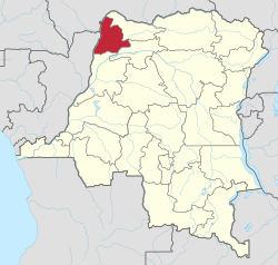
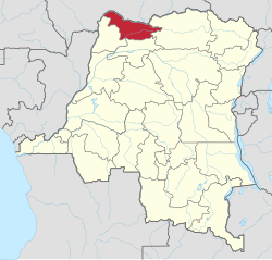
Coquilhatville Province was renamed Équateur Province in 1947. [5] There were further changes to boundaries. A 1955-1957 map shows Ubangi District bounded by French territory to the west and north, Mongala District to the east and Équateur District to the south. Ubangi district roughly corresponded to the present Sud-Ubangi province and the western part of Nord-Ubangi province. [6] The area was 64,900 square kilometres (25,100 sq mi) out of a total of 402,100 square kilometres (155,300 sq mi) for Equateur province as a whole. [7]

Post-independence

On 14 August 1962 Cuvette Centrale Province and Ubangi Province were separated from Équateur Province, and on 5 February 1963 the remainder became Moyen-Congo Province. These three provinces were combined into a new Équateur Province on 25 April 1966. On 11 July 2015 Équateur was split into the present provinces of Équateur, Mongala, Nord-Ubangi, Sud-Ubangi and Tshuapa. [5] The former Ubangi District is divided between Nord-Ubangi and Sud-Ubangi, which also contain part of the former Bangala District.

Maps

See also

Related Research Articles

<span class="mw-page-title-main">Équateur (former province)</span> Place in Democratic Republic of the Congo

Équateur was a province in the northwest of the Belgian Congo and the successor Republic of the Congo, now known as Democratic Republic of the Congo. It had its origins in the Équateur District of the Congo Free State, the private property of King Leopold II of Belgium. It was upgraded to the status of a province in 1917. Between 1933 and 1947 it was named Coquilhatville. In 1962 it was divided into three smaller provinces, but there were recombined in 1966. Équateur was one of the eleven provinces of the Democratic Republic of the Congo until 2015, when it was split into the new, smaller Équateur province, as well as the Tshuapa, Mongala, Nord-Ubangi and Sud-Ubangi provinces.

<span class="mw-page-title-main">Équateur District</span> District in Équateur Province, Democratic Republic of the Congo

Équateur District was a former district of the Congo Free State, Belgian Congo and Democratic Republic of the Congo. In 1914 it became part of former Équateur Province. The district went through various changes of extent and name over the years. The original district roughly corresponds to the current provinces of Équateur and Tshuapa.

<span class="mw-page-title-main">Cataractes District</span> District in Kongo Central, Democratic Republic of the Congo

Cataractes District was a district located in the Kongo Central province, in the Democratic Republic of the Congo. It dated back to the days of the Congo Free State and the Belgian Congo.

<span class="mw-page-title-main">Tshuapa District</span> District in Équateur, Democratic Republic of the Congo

Tshuapa District, was a district of the Belgian Congo and the Democratic Republic of the Congo created in 1933 in the Coquilhatville Province. At its greatest extent it roughly corresponded to the present provinces of Équateur and Tshuapa.

<span class="mw-page-title-main">Kwango District</span> District in Bandundu, Democratic Republic of the Congo

Kwango District was a district of the Congo Free State, Belgian Congo and the Democratic Republic of the Congo. It went through various changes in extent. It roughly corresponded to the present provinces of Kwilu and Kwango.

<span class="mw-page-title-main">Mongala District</span> District in Équateur, Democratic Republic of the Congo

Mongala District was a district of the Belgian Congo and the Democratic Republic of the Congo. It went through various changes in extent. It covered roughly the same area as the present Mongala province and most of Nord-Ubangi province.

<span class="mw-page-title-main">Districts of the Belgian Congo</span>

The Districts of the Belgian Congo were the primary administrative divisions when Belgium annexed the Congo Free State in 1908, each administered by a district commissioner. In 1914 they were distributed among four large provinces, with some boundary changes. In 1933 the provinces were restructured into six, again with boundary changes. The number of districts fluctuated between 12 and 26 through splits and consolidations, first rising, then falling, then rising again.

<span class="mw-page-title-main">Lac Léopold II District</span> District in Équateur, Belgian Congo

Lac Léopold II District was a district of the Congo Free State, Belgian Congo and Democratic Republic of the Congo. It went through various changes in extent, but roughly corresponded to the modern Mai-Ndombe Province.

Aruwimi District was a district of the Congo Free State and Belgian Congo. It went through various changes in extent before being absorbed into other districts.

<span class="mw-page-title-main">Stanleyville District</span> District in Orientale, Democratic Republic of the Congo

Stanleyville District was a district of the Belgian Congo and Democratic Republic of the Congo. It went through various changes in extent. Between 1933 and 1963 it had roughly the same extent as the current Tshopo province.

Uele District was a district of the Congo Free State and the Belgian Congo. It roughly corresponded to the current provinces of Bas-Uélé and Haut-Uélé.

Bangala District was a district of the Congo Free State and the Belgian Congo. It went through various significant changes in extent. The eastern part very roughly corresponded to the present province of Mongala.

<span class="mw-page-title-main">Bas-Congo District</span> District in Democratic Republic of the Congo

Bas-Congo was a district of the Belgian Congo and the Democratic Republic of the Congo. It went through various significant changes in extent. It roughly corresponds to the present province of Kongo Central.

Lulonga District was a district of the Belgian Congo created in 1912 and dissolved in 1933. Today part of Lulonga is in the current province of Équateur, and part in the province of Tshuapa.

<span class="mw-page-title-main">Stanley Pool District</span> District in Stanley Pool, Belgian Congo

Stanley Pool District, later named Moyen-Congo District was a district of the Congo Free State and Belgian Congo. It disappeared in a reorganization of 1914.

Congo-Ubangi District, was a district of the Belgian Congo created in 1933 in the Coquilhatville Province. It had been dissolved by 1954.

<span class="mw-page-title-main">Districts of the Congo Free State</span>

The Districts of the Congo Free State were the primary administrative divisions of the Congo Free State from 1885 to 1908. There were various boundary changes in the period before the Congo Free State was annexed by Belgium to become the Belgian Congo.

<span class="mw-page-title-main">Ubangi-Uélé District</span> District in Oubandji and Ouellé District, Congo Free State

The Ubangi-Uélé District was a district of the Congo Free State between 1888 and 1895. It was later split into the Ubangi District to the north and Bangala District to the south.

<span class="mw-page-title-main">Ernest Baert</span> Belgian soldier, explorer and colonial administrator

Ernest Baert was a Belgian soldier, explorer and colonial administrator who was active in the Congo Free State.

References

  1. 1 2 3 Omasombo Tshonda 2014, p. 211.
  2. Omasombo Tshonda 2015, p. 16.
  3. 1 2 3 Te Mobusa Ngbwapkwa 1993.
  4. 1 2 Atlas général du Congo.
  5. 1 2 3 Congo (Kinshasa) Provinces.
  6. Brass 2015, p. 243.
  7. Brass 2015, p. 254.

Sources