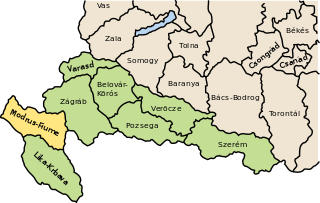
Districts from 1941–43

1941–1943
The districts (Croatian : kotar, pl. kotari, German : Bezirk) were the secondary territorial subdivisions of the Independent State of Croatia. There were 139 of them originally, with that number changing after the capitulation of Italy and the discontinuation of the Treaties of Rome. The districts were each a part of a county, and were themselves further divided into municipalities.


Rijeka, also known as Fiume, is the principal seaport and the third-largest city in Croatia. It is located in Primorje-Gorski Kotar County on Kvarner Bay, an inlet of the Adriatic Sea and in 2021 had a population of 108,622 inhabitants. Historically, because of its strategic position and its excellent deep-water port, the city was fiercely contested, especially between the Holy Roman Empire, Italy and Croatia, changing rulers and demographics many times over centuries. According to the 2011 census data, the majority of its citizens are Croats, along with small numbers of Serbs, Bosniaks and Italians.

The Independent State of Croatia was a World War II-era puppet state of Nazi Germany and Fascist Italy. It was established in parts of occupied Yugoslavia on 10 April 1941, after the invasion by the Axis powers. Its territory consisted of most of modern-day Croatia and Bosnia and Herzegovina, as well as some parts of modern-day Serbia and Slovenia, but also excluded many Croat-populated areas in Dalmatia, Istria, and Međimurje regions.

Krk is a Croatian island in the northern Adriatic Sea, located near Rijeka in the Bay of Kvarner and part of Primorje-Gorski Kotar county. Krk is tied with Cres as the largest Adriatic island, depending on the methodology used to measure the coastline. Krk is the most populous island in the Adriatic, with multiple towns and villages that contain a total of 19,916 (2021) inhabitants.
The Modruš-Rijeka County was a historic administrative subdivision of the Kingdom of Croatia-Slavonia. Croatia-Slavonia was an autonomous kingdom within the Lands of the Crown of Saint Stephen (Transleithania), the Hungarian part of the dual Austro-Hungarian Empire. Its territory is now in western Croatia. Modruš is a small town near Ogulin; Rijeka is a large city on the Adriatic coast. However, Rijeka was not part of the Modruš-Rijeka County, but under the direct administration of Hungary. The capital of the county was Ogulin.
The Yugoslav Partisans, or the National Liberation Army, officially the National Liberation Army and Partisan Detachments of Yugoslavia, was the communist-led anti-fascist resistance to the Axis powers in occupied Yugoslavia during World War II. Led by Josip Broz Tito, the Partisans are considered to be Europe's most effective anti-Axis resistance movement during World War II.
Šid is a town and municipality located in the Srem District of the autonomous province of Vojvodina, Serbia. It has a population of 14,893, while the municipality has 34,188 inhabitants. A border crossing between Serbia and Croatia is located in the town.

Gorski Kotar is the mountainous region in Croatia between Karlovac and Rijeka. Because 63% of its surface is forested it is popularly called the green lungs of Croatia or Croatian Switzerland. The European route E65, which connects Budapest and Zagreb with the Adriatic Port of Rijeka, passes through the region.
The Serbian Volunteer Corps, also known as Ljotićevci, was the paramilitary branch of the fascist political organisation Zbor, and collaborated with the forces of Nazi Germany in the German-occupied territory of Serbia during World War II.

Croatian Littoral is a historical name for the region of Croatia comprising mostly the coastal areas between traditional Dalmatia to the south, Mountainous Croatia to the north, Istria and the Kvarner Gulf of the Adriatic Sea to the west. The term "Croatian Littoral" developed in the 18th and 19th centuries, reflecting the complex development of Croatia in historical and geographical terms.

World War II in the Kingdom of Yugoslavia began on 6 April 1941, when the country was invaded and swiftly conquered by Axis forces and partitioned among Germany, Italy, Hungary, Bulgaria and their client regimes. Shortly after Germany attacked the USSR on 22 June 1941, the communist-led republican Yugoslav Partisans, on orders from Moscow, launched a guerrilla liberation war fighting against the Axis forces and their locally established puppet regimes, including the Axis-allied Independent State of Croatia (NDH) and the Government of National Salvation in the German-occupied territory of Serbia. This was dubbed the National Liberation War and Socialist Revolution in post-war Yugoslav communist historiography. Simultaneously, a multi-side civil war was waged between the Yugoslav communist Partisans, the Serbian royalist Chetniks, the Axis-allied Croatian Ustaše and Home Guard, Serbian Volunteer Corps and State Guard, Slovene Home Guard, as well as Nazi-allied Russian Protective Corps troops.
Yugoslavia had various administrative divisions throughout its 74 years of existence.

The Kingdom of Croatia was part of the Lands of the Hungarian Crown, but was subject to direct Imperial Austrian rule for significant periods of time, including its final years. Its capital was Zagreb. It was also a part of the lands of the Habsburg monarchy from 1527, following the Election in Cetin, and the Austrian Empire from 1804 to 1867.

The Navy of the Independent State of Croatia, was the navy of the Independent State of Croatia, an Axis puppet state controlled by the fascist Ustaše party. The NDH was created from parts of the Kingdom of Yugoslavia on 10 April 1941, four days after the World War II invasion of Yugoslavia by the Axis powers commenced. The RMNDH consisted of two commands, the Coast and Maritime Traffic Command, and the River and River Traffic Command, and had its headquarters in the NDH capital, Zagreb. The Coast and Maritime Traffic Command consisted of three naval commands along the Adriatic coast, which were each divided into a number of naval districts. The naval districts consisted mainly of naval and weather stations, and were only responsible for coast guard and customs duties. The River and River Traffic Command consisted of seven river stations, a naval infantry battalion, and a River Command Flotilla built around two former Yugoslav river monitors, which had been scuttled during the invasion but subsequently refloated.

The Governorate of Dalmatia was a territory divided into three provinces of Italy during the Italian Kingdom and Italian Empire epoch. It was created later as an entity in April 1941 at the start of World War II in Yugoslavia, by uniting the existing Province of Zara with occupied Yugoslav territory annexed by Italy after the invasion of Yugoslavia by the Axis powers and the signing of the Rome Treaties.

Pavle Đurišić was a Montenegrin Serb regular officer of the Royal Yugoslav Army who became a Chetnik commander (vojvoda) and led a significant proportion of the Chetniks in Montenegro during World War II. He distinguished himself and became one of the main commanders during the popular uprising against the Italians in Montenegro in July 1941, but later collaborated with the Italians in actions against the Communist-led Yugoslav Partisans. In 1943, his troops carried out several massacres against the Muslim population of Bosnia, Herzegovina, and the Sandžak in which an estimated 10,000 people were killed between January and March, including thousands of women, children, and the elderly. He then led his troops during their participation in the anti-Partisan Case White offensive alongside Italian forces. Đurišić was captured by the Germans in May 1943, escaped, and was recaptured.
Rijeka, formerly known as Fiume, is a city located in the northern tip of the Kvarner Gulf in the northern Adriatic. It is currently the third-largest city in Croatia. It was part of the Roman province of Dalmatia, and later of the Kingdom of Croatia. It grew during the 12th to 14th centuries as a seaport within the Holy Roman Empire, trading with Italian cities. Under the rule of the House of Habsburg from 1466, it was made a free city; and, although part of the Duchy of Carniola, it developed local self-government.

The 392nd (Croatian) Infantry Division was a so-called "legionnaire" division of the German Army during World War II. It was formed in August 1943 using Croatian Home Guard soldiers with a German cadre. The division was commanded by Germans down to battalion and even company level in nearly all cases. Originally formed with the intention of service on the Eastern Front, this did not eventuate, and the division was used in anti-Partisan operations in the territory of the Independent State of Croatia (NDH) until the end of the war. It was commonly known as the Blue Division.

Mladen Lorković was a Croatian politician and lawyer who became a senior member of the Ustaše and served as the Foreign Minister and Minister of Interior of the Independent State of Croatia (NDH) during World War II. Lorković led the Lorković-Vokić plot, an attempt to establish a coalition government between the Ustaše and the Croatian Peasant Party and align the Independent State of Croatia with the Allies.
The Ustaše Militia was the military branch of the Ustaše, established by the fascist and genocidal regime of Ante Pavelić in the Independent State of Croatia (NDH), an Axis puppet state established from a large part of occupied Yugoslavia during World War II.

The Province of Fiume was a province of the Kingdom of Italy from 1924 to 1943, then under control of the Italian Social Republic and German Wehrmacht from 1943 to 1945. Its capital was the city of Fiume. It took the other name after the Gulf of Carnaro.