Sanski Most

Last updated
Sanski Most
Сански Мост
Centar Sanskog Mosta.jpg
Zgrada opcine Sanski Most.jpg
Masinski most Sanski Most.jpg
Vodopad Blihe - panoramio - 87Edvin.jpg
Hamzibegova dzamija.jpg
Grb Sanskog Mosta.png
Bosnia and Herzegovina location map.svg
Red pog.svg
Sanski Most
Location of Sanski Most
Coordinates: 44°46′N16°40′E / 44.767°N 16.667°E / 44.767; 16.667
Country Flag of Bosnia and Herzegovina.svg  Bosnia and Herzegovina
Entity Federation of Bosnia and Herzegovina
Canton Flag of Una-Sana.svg  Una-Sana
Geographical region Bosanska Krajina
Subdivisions75
Government
  Municipal mayorFaris Hasanbegović (SDA)
Area
   Town and municipality 781 km2 (302 sq mi)
Population
 (2013 Census)
   Town and municipality 41,475
  Density53.10/km2 (137.5/sq mi)
   Urban
16,913
Time zone UTC+1 (CET)
  Summer (DST) UTC+2 (CEST)
Area code +387 37
Website www.sanskimost.gov.ba

Sanski Most (Cyrillic : Сански Мост, pronounced [sâːnskiːmɔ̂ːst] ) is a town and municipality located in the Una-Sana Canton of the Federation of Bosnia and Herzegovina, an entity of Bosnia and Herzegovina. It is situated on the banks of the Sana River in northwestern Bosnia and Herzegovina, in the region of Bosanska Krajina, between Prijedor and Ključ. As of 2013, it has a population of 41,475 inhabitants.

Contents

Geography

It is located on the Sana River in Bosanska Krajina, between Prijedor and Ključ. Administratively it is part of the Una-Sana Canton of the Federation of Bosnia and Herzegovina. The Town sits on Nine Rivers, the Nine Rivers are : Sana, Dabar, Zdena, Bliha, Majdanska Rijeka, Japra, Sasinka and Kozica

Climate

Climate data for Sanski Most (1991–2020)
MonthJanFebMarAprMayJunJulAugSepOctNovDecYear
Record high °C (°F)20.2
(68.4)
24.7
(76.5)
29.2
(84.6)
30.9
(87.6)
34.5
(94.1)
36.6
(97.9)
39.7
(103.5)
40.0
(104.0)
37.5
(99.5)
30.2
(86.4)
26.4
(79.5)
22.7
(72.9)
40.0
(104.0)
Mean daily maximum °C (°F)5.5
(41.9)
8.5
(47.3)
13.6
(56.5)
18.5
(65.3)
22.8
(73.0)
26.6
(79.9)
28.7
(83.7)
28.9
(84.0)
23.2
(73.8)
18.0
(64.4)
12.0
(53.6)
6.0
(42.8)
17.7
(63.9)
Daily mean °C (°F)0.8
(33.4)
2.4
(36.3)
6.7
(44.1)
11.3
(52.3)
15.7
(60.3)
19.7
(67.5)
21.3
(70.3)
20.8
(69.4)
15.8
(60.4)
11.3
(52.3)
6.6
(43.9)
1.7
(35.1)
11.2
(52.2)
Mean daily minimum °C (°F)−3.1
(26.4)
−2.5
(27.5)
0.9
(33.6)
4.9
(40.8)
9.2
(48.6)
13.0
(55.4)
14.4
(57.9)
14.3
(57.7)
10.4
(50.7)
6.5
(43.7)
2.5
(36.5)
−1.8
(28.8)
5.7
(42.3)
Record low °C (°F)−26.4
(−15.5)
−25.2
(−13.4)
−20.4
(−4.7)
−6.3
(20.7)
−1.1
(30.0)
0.5
(32.9)
4.5
(40.1)
4.0
(39.2)
−0.6
(30.9)
−6.8
(19.8)
−10.4
(13.3)
−21.4
(−6.5)
−26.4
(−15.5)
Average precipitation mm (inches)71.7
(2.82)
73.2
(2.88)
75.1
(2.96)
90.8
(3.57)
101.7
(4.00)
101.5
(4.00)
75.3
(2.96)
68.2
(2.69)
117.7
(4.63)
99.2
(3.91)
94.3
(3.71)
93.5
(3.68)
1,062.1
(41.81)
Average precipitation days (≥ 1.0 mm)8.89.19.010.410.39.57.76.99.38.99.810.3109.9
Mean monthly sunshine hours 74.399.7148.8179.7224.5250.7290.8267.7173.7130.878.862.51,981.9
Source: NOAA [1]

History

In 1878 the little town (varošica) of Sanski Most was described as Muslim by Croatian historian Vjekoslav Klaić. [2] From 1929 to 1941, Sanski Most was part of the Vrbas Banovina of the Kingdom of Yugoslavia.

During World War II it was part of the Axis Independent State of Croatia (NDH), where the fascist Ustaše regime committed the Genocide of the Serbs and the Holocaust. At the beginning of May 1941 in several villages south-east of Sanski Most (Kijevo, Tramošnja, Kozica, etc.) the first armed conflict between the Ustaše and insurgent Serbs occurred. The event is known as the Đurđevdan uprising. In August 1941 on the Eastern Orthodox Elijah's holy day, who is the patron saint of Bosnia and Herzegovina, between 2,800 and 5,500 Serbs from Sanski Most and the surrounding area were killed and thrown into pits which have been dug by victims themselves. [3] The State Anti-fascist Council for the National Liberation of Bosnia and Herzegovina (ZAVNOBiH) held its second meeting from 30 June to 2 July 1944 in the town; it declared the equality of Muslims (Bosniaks), Serbs and Croats.

During the Bosnian War, the town was controlled by the Army of Republika Srpska (Bosnian Serbs) and remained under its control until October 1995 when the Army of Bosnia and Herzegovina took over it during Operation Sana shortly before the end of the war. The Bosniaks and other Non Serbs were set to large ethnic cleansing during its control by the Army of Republika Srpska (VRS). Many Serbs from Sanski Most and Bosniaks from Prijedor exchanged homes due to their refugee status and the opposing federations. [4]

Vrhpolje bridge massacre

On 31 May 1992, the Army of Republika Srpska committed a massacre of 19 Bosniak civilians on the Vrhpojle bridge in Sanski Most municipality. 16 Bosniak civilians were beaten on the bridge whilst the Bosnian Serb soldiers cursed and insulted them. 4 had already been murdered by the VRS on the way to the bridge. The Bosnian Serbs had ordered the Bosniak civilians to remove most of their clothes, including their shoes, and then jump off the bridge. The Bosnian Serb soldiers played a game in which they tried to shoot the Bosniak civilians mid-air whilst they were falling into the water. There was only one survivor of the massacre, Rajif Begić, who later testified against Ratko Mladić. According to the ICTY trial, Ratko Mladić was responsible for the murder of the Bosniak civilians which the court found was a deliberate attempt to ethnically cleanse the Serb-controlled parts of Bosnia and Herzegovina of their Bosniak population in order to create a homogenously Serb ethno-state. According to Begić's testimony, the VRS had to kill 70 Muslims that day because "seven Serb soldiers had been killed in that area." Branko Basara, the retired commander of the 6th Krajina Brigade was also indicted by the ICTY for war crimes that he committed in the Prijedor and Sanski Most area during 1992. Jadranko Palija, a Bosnian Serb soldier responsible for the massacre, was convicted of war crimes by the State Court of Bosnia and Herzegovina in 2007. [5] [6]

In 1996, Serb-inhabited Oštra Luka was split from Sanski Most and ceded to the Republika Srpska entity.

Demographics

Population

Population of settlements – Sanski Most municipality
Settlement1961.1971.1981.1991.2013.
Total39,48362,10262,46760,30750,421
1Brdari539443
2Čaplje1,4201,264
3Demiševci498440
4Donji Kamengrad2,3442,336
5Dževar685681
6Fajtovci369362
7Gorice644615
8Gornji Kamengrad1,3871,311
9Hrustovo1,6941,697
10Husimovci1,8021,310
11Kijevo1,118682
12Krkojevci304361
13Lukavice606486
14Lušci Palanka1,079226
15Modra578595
16Naprelje822605
17Okreč1,1041,021
18Podbriježje570529
19Podlug650550
20Podvidača679275
21Poljak522483
22Sanski Most8,68214,02717,14419,745
23Sasina1,054294
24Šehovci960880
25Skucani Vakuf1,3211,434
26Stari Majdan1,212762
27Tomina1,5131,107
28Trnova978783
29Vrhpolje1,8402,035

Ethnic composition

Ethnic composition – Sanski Most town
2013.1991.1981.1971.
Total19,745 (100,0%)17,144 (100,0%)14,027 (100,0%)8,682 (100,0%)
Serbs401 (2,37%)7,831 (45,68%)5,691 (40,57%)3,410 (39,27%)
Bosniaks15,930 (94,19%)7,245 (42,26%)6,067 (43,25%)4,545 (52,34%)
Jugoslaveni901 (5,255%)1,504 (10,72%)96 (1,10%)
Croats177 (1,05%)646 (3,768%)523 (3,729%)558 (6,42%)
Others405 (2,39%)521 (3,039%)242 (1,725%)73 (0,84%)
Ethnic composition – Sanski Most municipality
2013.1991.1981.1971.1961.
Total50,421 (100,0%)60,307 (100,0%)62,467 (100,0%)62,102 (100,0%)39,483 (100,0%)
Bosniaks38,344 (92,45%)28,136 (46,65%)27,083 (43,36%)24,839 (40,00%)12,350 (31.28%)
Serbs1,837 (4,429%)25,363 (42,06%)26,619 (42,61%)30,422 (48,99%)19,156 (48.52%)
Croats722 (1,741%)4,322 (7,167%)5,314 (8,507%)6,307 (10,16%)4,844 (12.27%)
Others572 (1,379%)1,239 (2,054%)336 (0,538%)213 (0,343%)
Yugoslavs1,247 (2,068%)2,936 (4,700%)195 (0,314%)3,014 (7.63%)
Roma75 (0,120%)12 (0,019%)
Montenegrins50 (0,080%)59 (0,095%)
Albanians26 (0,042%)22 (0,035%)
Slovenes16 (0,026%)23 (0,037%)
Macedonians10 (0,016%)8 (0,013%)
Hungarians2 (0,003%)2 (0,003%)

Economy

EmploymentMaleFemaleTotalTotal PopulationUnemployment %
20143,3841,3634,74750,42153.91% [7]

There are several non-governmental organisations in Sanski Most. Center for Peacebuilding, in the local language "Centar za Izgradnju Mira (CIM)" has been active in the city since 2004. The "Fenix Center", Centar Fenix provides humanitarian aid to the persons in need in the local community. The organisation "Krajiška Suza" is providing care in medical, social, psychological, cultural and existential needs of people living in and around Sanski Most. Austrian manufacturer of exhaust pipes Remus has a manufacturing facility in Sanski Most that employs around 300 people. [8] [9] Sanski Most was selected as one of the most successful local communities within the UNDP project that was financed by Swiss embassy. [10]

Sport

The football club of the town is NK Podgrmeč.

Notable people

See also

Related Research Articles

The Army of Republika Srpska, commonly referred to in English as the Bosnian Serb Army, was the military of Republika Srpska, the self-proclaimed Serb secessionist republic, a territory within the newly independent Bosnia and Herzegovina, which it defied and fought against. Active during the Bosnian War from 1992 to 1995, it continued to exist as the armed forces of RS, one of two entities making up Bosnia and Herzegovina, until 2006 when it was integrated into the Armed Forces of Bosnia and Herzegovina. Forces of the VRS engaged in several campaigns, including Operation Corridor 92, Operation Vrbas '92, Operation Bura, and Operation Spider; they were also involved in the siege of Sarajevo, as well as the Srebrenica massacre.

<span class="mw-page-title-main">Una-Sana Canton</span> Canton of the Federation of Bosnia and Herzegovina

The Una-Sana Canton is one of the ten cantons of the Federation of Bosnia and Herzegovina entity within Bosnia and Herzegovina. It is located in the northwest of the country and has been named after the rivers Una and Sana. The center of the cantonal government is Bihać. The canton is bordered by Republika Srpska from east, Canton 10 from southeast, and Croatia from south, west, and north.

<span class="mw-page-title-main">Bosanska Krajina</span> Subregion of Bosnia

Bosanska Krajina is a geographical region, a subregion of Bosnia, in western Bosnia and Herzegovina. It is enclosed by a number of rivers, namely the Sava (north), Glina (northwest), Vrbanja and Vrbas. The region is also a historic, economic and cultural entity of Bosnia and Herzegovina, noted for its preserved nature and wildlife diversity.

<span class="mw-page-title-main">Bosnian genocide</span> Murder of Bosniaks and Bosnian Croats during the Bosnian War

The Bosnian genocide refers to either the Srebrenica massacre or the wider crimes against humanity and ethnic cleansing campaign throughout areas controlled by the Army of Republika Srpska (VRS) during the Bosnian War of 1992–1995. The events in Srebrenica in 1995 included the killing of more than 8,000 Bosniak men and boys, as well as the mass expulsion of another 25,000–30,000 Bosniak civilians by VRS units under the command of General Ratko Mladić.

<span class="mw-page-title-main">SAO Bosanska Krajina</span>

The Serbian Autonomous Oblast of Bosanska Krajina was a self-proclaimed Serbian Autonomous Oblast within today's Bosnia and Herzegovina. It was sometimes called the Autonomous Oblast of Krajina, or the Autonomous Region of Krajina (ARK). SAO Bosanska Krajina was located in the geographical region named Bosanska Krajina. Its capital was Banja Luka. The region was subsequently included into Republika Srpska.

<span class="mw-page-title-main">Novi Grad, Bosnia and Herzegovina</span> Town and municipality in Bosnia and Herzegovina

Novi Grad, formerly Bosanski Novi, is a town and municipality in Republika Srpska, Bosnia and Herzegovina. Situated in the far northwest of the country, it lies across the Una from the Croatian town of Dvor. According to the 2013 census, the town has a population of 11,063 while its municipality comprises a total of 27,115 inhabitants.

<span class="mw-page-title-main">Republika Srpska (1992–1995)</span> Former proto-state

The Republika Srpska was a self-proclaimed statelet in Southeastern Europe under the control of the Army of Republika Srpska during the Bosnian War. It claimed to be a sovereign state, though this claim was only partially recognized by the Bosnian government in the Geneva agreement, the United Nations, and FR Yugoslavia. For the first six months of its existence, it was known as the Serbian Republic of Bosnia and Herzegovina.

<span class="mw-page-title-main">Oštra Luka</span> Village and municipality in Republika Srpska, Bosnia and Herzegovina

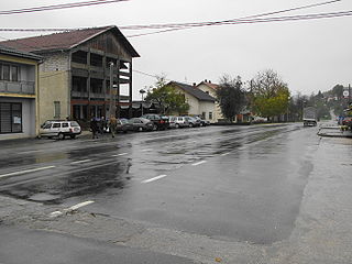
Oštra Luka is a village and municipality in Republika Srpska, Bosnia and Herzegovina. As of 2013, the municipality has a population of 2,786 inhabitants, with 782 in Oštra Luka itself.

Atif Dudaković is a retired Bosniak general who served in the Army of Republic of Bosnia and Herzegovina. During the Bosnian War, Dudaković was in command of the Bihać enclave, which was surrounded and besieged from 1992 to 1995, commanding the 5th Corps. After the war he became the general commander of the Army of the Federation of Bosnia and Herzegovina. In 2018, he was charged with war crimes.

<span class="mw-page-title-main">Sana (river)</span> River in Bosnia and Herzegovina

The Sana is a river in the north-western part of Bosnia and Herzegovina. It is a tributary of the Una, which it flows into at Novi Grad. It is the longest of the nine rivers that flow through Sanski Most, and is 142 km long. It is not a navigable waterway.

Operation Sana was the final military offensive of the Army of the Republic of Bosnia and Herzegovina in western Bosnia and Herzegovina and the last major battle of the Bosnian War. It was launched from the area of Bihać on 13 September 1995, against the Army of Republika Srpska, and involved advances towards Bosanski Petrovac, Sanski Most and Bosanska Krupa. At the same time, the Croatian Army and the Croatian Defence Council were engaging the VRS in Operation Maestral 2 further to the southeast. After an initial 70-kilometre (43 mi) advance, VRS reinforcements managed to stop the ARBiH short of Sanski Most and Novi Grad, and reversed some of the ARBiH's territorial gains in a counterattack. After a part of the ARBiH 5th Corps was threatened with defeat around the town of Ključ, the ARBiH requested assistance from the HV.

<span class="mw-page-title-main">Prijedor ethnic cleansing</span>

During the Bosnian War, there was an ethnic cleansing campaign committed by the Bosnian Serb political and military leadership – Army of the Republika Srpska, mostly against Bosniak and Croat civilians in the Prijedor region of Bosnia and Herzegovina in 1992 and 1993. The composition of non-Serbs was drastically reduced: out of a population of 50,000 Bosniaks and 6,000 Croats, only some 6,000 Bosniaks and 3,000 Croats remained in the municipality by the end of the war. After the Srebrenica massacre, Prijedor is the area with the second highest rate of civilian killings committed during the Bosnian War. According to the Sarajevo-based Research and Documentation Center (IDC), 4,868 people were killed or went missing in the Prijedor municipality during the war. Among them were 3,515 Bosniak civilians, 186 Croat civilians and 78 Serb civilians. As of October 2013, 96 mass graves have been located and around 2,100 victims have been identified, largely by DNA analysis.

<span class="mw-page-title-main">Siege of Srebrenica</span> 1992 - 1995 siege during the Bosnian War

The siege of Srebrenica was a three-year siege of the town of Srebrenica in eastern Bosnia and Herzegovina which lasted from April 1992 to July 1995 during the Bosnian War. Initially assaulted by the Yugoslav People's Army (JNA) and the Serbian Volunteer Guard (SDG), the town was encircled by the Army of Republika Srpska (VRS) in May 1992, starting a brutal siege which was to last for the majority of the Bosnian War. In June 1995, the commander of the Army of the Republic of Bosnia and Herzegovina (ARBiH) in the enclave, Naser Orić, left Srebrenica and fled to the town of Tuzla. He was subsequently replaced by his deputy, Major Ramiz Bećirović.

Ljubija is a small town in Bosnia and Herzegovina. It is located in the Bosanska Krajina region in the northwestern part of the country. Administratively, it belongs to the Prijedor municipality.

Operation Una was a military offensive conducted by the Croatian Army against the Army of Republika Srpska in western Bosnia and Herzegovina on 18–19 September 1995, during the Bosnian War. The operation entailed a crossing of the Una and Sava rivers to establish bridgeheads at Novi Grad, Bosanska Dubica, Bosanska Kostajnica and opposite Jasenovac to allow for a subsequent advance towards Prijedor and Banja Luka.

Operation Southern Move was the final Croatian Army (HV) and Croatian Defence Council (HVO) offensive of the Bosnian War. It took place in western Bosnia and Herzegovina on 8–11 October 1995. Its goal was to help the Army of the Republic of Bosnia and Herzegovina (ARBiH) whose positions around the town of Ključ, captured by them during Operation Sana, were endangered by a counteroffensive by the Army of Republika Srpska (VRS). The objectives of Operation Southern Move included the capture of the town of Mrkonjić Grad and positions on the Manjača Mountain which would allow the HV and the HVO to directly threaten Banja Luka, the largest city controlled by Bosnian Serbs. Finally, the offensive was also aimed at capturing the Bočac Hydroelectric Power Station, the last significant source of electricity under VRS control in western Bosnia and Herzegovina. The combined HV and HVO forces were under the overall command of HV Major General Ante Gotovina.

<span class="mw-page-title-main">16th Krajina Motorized Brigade</span> Military unit

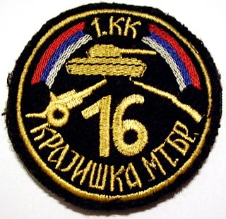
The 16th Krajina Motorized Brigade was a motorized unit based in Banja Luka part of the 1st Krajina Corps of the Army of Republika Srpska.

Radio Sana is a Bosnian local public radio station, broadcasting from Sanski Most, Bosnia and Herzegovina.

<span class="mw-page-title-main">5th Division (Yugoslav Partisans)</span> Military unit

The 5th Krajina Division was a Yugoslav Partisan division formed in Glamočko polje on 9 November 1942.

<span class="mw-page-title-main">Operation "Breza '94"</span> Military operation during the Bosnian War

Operation "Breza 94" was the official codename for the military offensive conducted by the 1st Krajina Corps of the VRS in September 1994 in Bosanska Krajina. The objective of the offensive was the breaking of the 5th Corps and the conquest of Bosanska Krajina. The offensive ended in VRS defeat with the ARBiH capturing 20 square kilometers previously held by Serbs.

References

Citations

  1. "Sanski Most Climate Normals 1991–2020". World Meteorological Organization Climatological Standard Normals (1991–2020). National Oceanic and Atmospheric Administration. Retrieved 4 September 2023.
  2. Klaić, Vjekoslav (1878). Bosna: podatci o zemljopisu i poviesti Bosne i Hercegovine. Naklad. "Matice Hrvatske". p. 192.
  3. Mojzes, Paul (2011). Balkan Genocides: Holocaust and Ethnic Cleansing in the 20th Century. Lanham: Rowman & Littlefield. pp. 75–76. ISBN   9781442206632.
  4. Gilbert 2020, p. 110.
  5. Refugees, United Nations High Commissioner for. "Refworld | Mladic Witness Denies Army Role in Sanski Most Killings". Refworld. Retrieved 2023-09-29.
  6. "Witness Recalls Sanski Most Bridge Killings". iwpr.net. Retrieved 2023-09-29.
  7. "Sanski Most | myplace". www.mojemjesto.ba. Archived from the original on 2012-07-20.
  8. "Remus to build a new production facility in Sanski Most". www.see-industry.com. Retrieved 2020-07-18.
  9. "Remus Innovation will hire 300 workers in Sanski Most". Sarajevo Times. 2012-12-27. Retrieved 2020-07-18.
  10. Fena. "Sanski Most privlači sve više investicija i ostvaruje veliki ekonomski napredak". Radio Sarajevo. Retrieved 2020-07-18.

Bibliography

Gilbert, Andrew (2020). International Intervention and the Problem of Legitimacy Encounters in Postwar Bosnia-Herzegovina. Cornell University Press.