Vrhpolje, Sanski Most

Last updated
Vrhpolje
Village
Bosnia and Herzegovina location map.svg
Red pog.svg
Vrhpolje
Coordinates: 44°39′59″N16°44′16″E / 44.666391°N 16.737662°E / 44.666391; 16.737662 Coordinates: 44°39′59″N16°44′16″E / 44.666391°N 16.737662°E / 44.666391; 16.737662
Country Flag of Bosnia and Herzegovina.svg  Bosnia and Herzegovina
Entity Federation of Bosnia and Herzegovina
Canton Flag of Una-Sana.svg  Una-Sana
Municipality Grb Sanskog Mosta.png Sanski Most
Area
  Total4.82 sq mi (12.48 km2)
Population
 (2013)
  Total2,035
  Density420/sq mi (160/km2)
Time zone UTC+1 (CET)
  Summer (DST) UTC+2 (CEST)

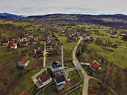
Vrhpolje is a village in the municipality of Sanski Most, Federation of Bosnia and Herzegovina, Bosnia and Herzegovina. [1] [2]

Demographics

According to the 2013 census, its population was 2,035. [3]

Ethnicity in 2013
EthnicityNumberPercentage
Bosniaks 2,02799.6%
other/undeclared80.4%
Total2,035100%

Related Research Articles

Brdari is a village in the municipality of Sanski Most, Federation of Bosnia and Herzegovina, Bosnia and Herzegovina.

Čaplje is a village in the municipality of Sanski Most, Federation of Bosnia and Herzegovina, Bosnia and Herzegovina.

Demiševci is a village in the municipality of Sanski Most, Federation of Bosnia and Herzegovina, Bosnia and Herzegovina.

Donji Kamengrad is a village in the municipality of Sanski Most, Federation of Bosnia and Herzegovina, Bosnia and Herzegovina.

Dževar is a village in the municipality of Sanski Most, Federation of Bosnia and Herzegovina, Bosnia and Herzegovina.

Fajtovci is a village in the municipality of Sanski Most, Federation of Bosnia and Herzegovina, Bosnia and Herzegovina.

Gorice is a village in the municipality of Sanski Most, Federation of Bosnia and Herzegovina, Bosnia and Herzegovina.

Hrustovo is a village in the municipality of Sanski Most, Federation of Bosnia and Herzegovina, Bosnia and Herzegovina.

Husimovci is a village in the municipality of Sanski Most, Federation of Bosnia and Herzegovina, Bosnia and Herzegovina.

Kijevo is a village in the municipality of Sanski Most, Federation of Bosnia and Herzegovina, Bosnia and Herzegovina.

Krkojevci is a village in the municipality of Sanski Most, Federation of Bosnia and Herzegovina, Bosnia and Herzegovina.

Lušci Palanka is a village in the municipality of Sanski Most, Federation of Bosnia and Herzegovina, Bosnia and Herzegovina.

Okreč is a village in the municipality of Sanski Most, Federation of Bosnia and Herzegovina, Bosnia and Herzegovina.

Podbriježje is a village in the municipality of Sanski Most, Federation of Bosnia and Herzegovina, Bosnia and Herzegovina.

Podlug is a village in the municipality of Sanski Most, Federation of Bosnia and Herzegovina, Bosnia and Herzegovina.

Podvidača is a village in the municipality of Sanski Most, Federation of Bosnia and Herzegovina, Bosnia and Herzegovina.

Šehovci is a village in the municipality of Sanski Most, Federation of Bosnia and Herzegovina, Bosnia and Herzegovina.

Tomina is a village in the municipality of Sanski Most, Federation of Bosnia and Herzegovina, Bosnia and Herzegovina.

Trnova is a village in the municipality of Sanski Most, Federation of Bosnia and Herzegovina, Bosnia and Herzegovina.

Kruhari is a village in the municipality of Sanski Most, Federation of Bosnia and Herzegovina, Bosnia and Herzegovina.

References

  1. Official results from the book: Ethnic composition of Bosnia-Herzegovina population, by municipalities and settlements, 1991. census, Zavod za statistiku Bosne i Hercegovine - Bilten no.234, Sarajevo 1991.
  2. Informacije o Mjesnim zajednicama - Sanski Most (in Bosnian)
  3. "Naseljena Mjesta 1991/2013" (in Bosnian). Statistical Office of Bosnia and Herzegovina . Retrieved September 11, 2021.