Neum

Last updated

Neum
Неум
Neum, Adriatic Sea, Bosnia and Herzegovina.jpg
Neum
Flag of Neum, Bosnia and Herzegovina.gif
Coat of Arms of Neum.svg
BiH municipality location Neum.svg
Location of Neum municipality within Bosnia and Herzegovina
Neum
Coordinates: 42°55′30″N17°37′00″E / 42.92500°N 17.61667°E / 42.92500; 17.61667
Country Flag of Bosnia and Herzegovina.svg  Bosnia and Herzegovina
Entity Federation of Bosnia and Herzegovina
Canton Flag of Herzegovina-Neretva.svg  Herzegovina-Neretva
Geographical region Herzegovina
Government
  Municipal mayorDragan Jurković (HDZ BiH)
Area
  Total246.03 km2 (94.99 sq mi)
Population
 (2013 census)
  Total4,653
  Density22/km2 (60/sq mi)
Time zone UTC+1 (CET)
  Summer (DST) UTC+2 (CEST)
Area code +387 36
Website www.neum.ba

Neum (Cyrillic : Неум, pronounced [něum] ) is a town and municipality in Bosnia and Herzegovina, located in Herzegovina-Neretva Canton of the Federation of Bosnia and Herzegovina. It is the only town on the Bosnia and Herzegovina coastline, making it the country's only access to the Adriatic Sea. As of 2013, Neum municipality has a population of 4,653 inhabitants, while the town of Neum has a population of 3,013 inhabitants.

Contents

Geography

Neum is the only town situated along Bosnia and Herzegovina's 20-kilometre (12 mi) coastline, [1] making it the country's only access to the Adriatic Sea. [2]

Neum is 47 km (29 mi) northwest of Dubrovnik, 50 km (31 mi) south of Mostar, and 122 km (76 mi) southwest of Sarajevo, the country's capital.

The Bosnia and Herzegovina coastal strip of Neum cuts off the southernmost Croatian exclave from the rest of Croatia. This is a result of the Treaty of Karlowitz of 1699. Since 1991 and the breakup of Yugoslavia, the border between Croatia and Bosnia and Herzegovina in the Neum region have been international borders. [3]

Subdivision

The municipality includes the town of Neum (municipal seat) and several villages: [4]

Babin Do, Borut, Brestica, Broćanac, Brštanica, Cerovica, Cerovo, Crnoglav, Dobri Do, Dobrovo, Donji Drijen, Donji Zelenikovac, Dubravica, Duži, Glumina, Gornje Hrasno, Gradac, Hotanj Hutovski, Hutovo, Kiševo, Moševići, Prapratnica, Previš, Rabrani, Vinine and Žukovica.

Border crossings

Neum has two border crossing checkpoints with Croatia on the European route E65 or Adriatic Highway which connects the two parts of Croatia's Dalmatian coast. Neum 1 is located to the northwest of the city, with the Klek border checkpoint on the Croatian side. Neum 2 is located to the southeast, with the Croatian border checkpoint at Zaton Doli.

History

The Neum corridor dates back to the Treaty of Karlowitz of 1699, whereby the Republic of Ragusa was separated from the Dalmatian possessions of its rival Venice by two buffer zones ceded by Ragusa to the Ottoman Empire to prevent the possibility of Venice invading via land: [5] [6] north of its territory is Neum and the bay of Klek, and south of its territory is Sutorina with the port of Herceg Novi on the Bay of Kotor, part of Montenegro since 1947 (later the topic of the now-resolved Sutorina dispute).

The Karlowitz borders were reaffirmed in 1718 by the Treaty of Passarowitz, but then the Ottomans, tired of negotiating in vain with Venice for a widening of their maritime access, simply usurped the territory of Gornji Klek and most of Klek from Ragusa, which it had bought from King Dabiša of Bosnia at the end of the 14th century. After the fall of the Republic of Venice in 1797, and the Congress of Vienna in 1815, the Austrian Empire, which had annexed both the Dalmatian possessions of Venice and the territory of Ragusa, tried to buy back the Neum and Sutorina enclaves from the Ottomans, but in vain. Instead, it stationed a warship to block access to the port of Neum until the Treaty of Berlin, which gave the whole of Bosnia and Herzegovina to Austria-Hungary in 1878. Neum had been under Ottoman control for 179 years.

Consideration was given to a plan to build a new advanced naval base at Neum-Klek by the Austro-Hungarian Navy. General Franz Conrad von Hötzendorf considered fortifying Neum with coastal batteries and torpedo craft to supplement seafront defenses (in order to prevent Italian raids, or worse a large scale Italian landing). The project never got past the planning stage prior to the outbreak of World War I in 1914. [7]

In 1918, as a consequence of Austro-Hungarian defeat, Neum joined the Kingdom of Serbs, Croats and Slovenes which would become the Kingdom of Yugoslavia in 1929. Under the Karađorđević dynasty, the Yugoslav Government ignored the borders inherited from history twice: in 1929, when the Neum area was included in the Littoral Banovina, and in 1939 when, following the Cvetković–Maček Agreement, it was included in the Banovina of Croatia. Josip Broz Tito's federal Yugoslavia was founded on the principle, declared at the 1943 AVNOJ session in Jajce and comparatively well-respected by the Đilas commission in 1945, of establishing the federative republics in their borders of 1878, which is why the Neum enclave is now part of independent Bosnia and Herzegovina, including most of Klek (Ponta Kleka, Rep Kleka), the two islets Veliki and Mali Školj and the rock of Lopata in the Bay of Klek. [8]

Since the 1990s, Croatia and Bosnia and Herzegovina have been in negotiations on how to handle traffic across the Neum region, including signing a Neum Agreement. When Croatia was admitted to the European Union in 2013, the border crossings in the Neum region became governed as external borders of the EU.[ citation needed ] The construction and opening in 2022 of the Pelješac Bridge, which bypasses Neum entirely, has significance for Croatia's integrity and also for its future Schengen Area membership and the EU as a whole. It significantly improves traffic flow and the traffic connection of Dubrovnik to the rest of mainland Croatia, avoiding negotiating long, costly queues at Neum, and strict customs checks twice within the space of 20 kilometres (12 mi).

Encouraged by the recent developments in Croatia–Slovenia border disputes (June 2017), the ruling Bosniak Party of Democratic Action (SDA) and other Bosniak political parties decided to obstruct [ citation needed ] the construction.

The construction cost was €420 million, to which the EU contributed by allocating €357 million from Cohesion Policy funds. The bridge is among the largest infrastructures in Croatia currently and one of the most substantial EU infrastructural investment ever. The work was completed in mid 2022. The EU is also funding supporting infrastructure, such as the construction of access roads, including tunnels, bridges and viaducts, the building of an 8 km-long bypass near the town of Ston and upgrading works on the existing road D414. [9]

There are Bosniak plans to convert Neum to a freight port, contrary to the wishes of the local population and international laws and agreements concerning the ecologically significant and protected Bay of Mali Ston, of which Bay of Neum is a part. There are plans to build a seaport, rail and a motorway and thus the Croatian bridge must have a high clearance according to the view of Bosnia and Herzegovina's Bosniak political parties. Due to the above, the Republic of Croatia has significantly increased the height of the bridge by adapting it to ships whose dimensions cannot enter the Bay of Neum at all. Today the main freight port for Bosnia and Herzegovina is Ploče (in Croatia) further north, which has a railway to Bosnia and Herzegovina.[ citation needed ]

Climate

The climate of the area is Mediterranean, characterized by mild winters and dry summers, with three times more rain in the rainier than in the drier months, during which the mean precipitation does not exceed 40 mm (1.6 in). The mean yearly precipitation observed is of 1,316 mm (51.8 in). The dominant winds come from the north, north-east and north-west. The average sea temperature (as observed in Neum) ranges from 13 °C (55 °F) in January to 28 °C (82 °F) in July and August.

Vegetation is the evergreen Mediterranean type, and subtropical flora (palm trees, agaves, cacti) grow in Neum and its surroundings.

Climate data for Neum
MonthJanFebMarAprMayJunJulAugSepOctNovDecYear
Mean daily maximum °C (°F)9.7
(49.5)
11.3
(52.3)
14.3
(57.7)
17.5
(63.5)
22.5
(72.5)
26.2
(79.2)
29.7
(85.5)
29.4
(84.9)
25.9
(78.6)
20.6
(69.1)
14.8
(58.6)
11.2
(52.2)
19.4
(67.0)
Daily mean °C (°F)6.6
(43.9)
7.9
(46.2)
10.2
(50.4)
13.0
(55.4)
17.6
(63.7)
21.2
(70.2)
24.4
(75.9)
24.2
(75.6)
20.9
(69.6)
16.3
(61.3)
11.4
(52.5)
8.2
(46.8)
15.2
(59.4)
Mean daily minimum °C (°F)3.6
(38.5)
4.5
(40.1)
6.1
(43.0)
8.6
(47.5)
12.7
(54.9)
16.3
(61.3)
19.2
(66.6)
19.0
(66.2)
16.0
(60.8)
12.1
(53.8)
8.0
(46.4)
5.2
(41.4)
10.9
(51.7)
Average precipitation mm (inches)135
(5.3)
123
(4.8)
106
(4.2)
100
(3.9)
75
(3.0)
59
(2.3)
38
(1.5)
52
(2.0)
88
(3.5)
127
(5.0)
174
(6.9)
172
(6.8)
1,249
(49.2)
[ citation needed ]

Demographics

All demographic data per Statistica.ba website: [4]

Population

Population of settlements – Neum municipality
Settlement1971.1981.1991.2013.
Total4,7814,0304,3254,960
1Gradac345234
2Hutovo319201
3Neum3606021,6513,013

Ethnic composition

Ethnic composition – Neum town
2013.1991.1981.1971.
Total3,013 (100%)1,651 (100%)602 (100%)360 (100%)
Croats2,938 (97.51%)1,338 (81.04%)499 (82.89%)335 (93.06%)
Bosniaks33 (1.161%)89 (5.391%)17 (2.824%)3 (0.833%)
Serbs21 (0.697%)98 (5.936%)25 (4.153%)10 (2.778%)
Unaffiliated6 (0.199%)
Albanians3 (0.1%)4 (0.664%)
Unknown3 (0.1%)
Others3 (0.100%)36 (2.180%)3 (0.498%)5 (1.389%)
Yugoslavs2 (0.066%)90 (5.451%)47 (7.807%)7 (1.944%)
Montenegrins2 (0.066%)6 (0.997%)
Macedonians1 (0.166%)
Ethnic composition – Neum municipality
2013.1991.1981.
Total4,960 (100%)4,325 (100%)4,030 (100%)
Croats4,543 (97.64%)3,792 (87.68%)3,575 (88.71%)
Bosniaks63 (1.397%)190 (4.393%)157 (3.896%)
Serbs21 (0.451%)207 (4.786%)179 (4.442%)
Unaffiliated7 (0.15%)
Unknown7 (0.15%)
Albanians3 (0.064%)5 (0.124%)
Others3 (0.064%)46 (1.064%)17 (0.422%)
Yugoslavs2 (0.043%)90 (2.081%)89 (2.208%)
Montenegrins2 (0.043%)7 (0.174%)
Macedonians1 (0.025%)

Culture and sport

The linđo is traditionally danced in the Neum region. [10] Neum celebrates the feast of Our Lady of Good Health as its municipal day. As part of the celebrations, Neum hosts the Music Festival Etnofest Neum. The town also hosts the Neum Animated Film Festival. [11]

Neum is home to local branches of the cultural organizations Matica hrvatska and HKD Napredak. [12] [13]

Popular activities include swimming and sun bathing, beach-going, boating, and various other water-sports. Neum has a water polo club VK Jadran Neum, which is a member of the Croatian Water Polo Federation.

There is also an association football club HNK Neum.

Tourism

Neum area has steep hills, stone-sandy beaches, and several large tourist hotels. Neum has about 5,000 beds for tourists, 1,810 in hotels with the remaining capacity in motels, villas, and private accommodation. Tourism in Neum is active only in the coastal region. Prices tend to be lower than in neighbouring Croatia, making it popular with shoppers. Tourism, and the commerce it brings, is the leading contributor to the economy of the area.


The inland area behind Neum has a rich archeological history and wilderness with centuries-old olive groves.

See also

Related Research Articles

<span class="mw-page-title-main">Dubrovnik</span> Coastal city in southern Croatia

Dubrovnik, historically known as Ragusa, is a city in southern Dalmatia, Croatia, by the Adriatic Sea. It is one of the most prominent tourist destinations in the Mediterranean, a seaport and the centre of the Dubrovnik-Neretva County. Its total population is 41,562. In 1979, the city of Dubrovnik was added to the UNESCO list of World Heritage Sites in recognition of its outstanding medieval architecture and fortified old town.

<span class="mw-page-title-main">Herzegovina-Neretva Canton</span> Canton in Bosnia and Herzegovina

The Herzegovina-Neretva Canton is one of 10 cantons of the Federation of Bosnia and Herzegovina in Bosnia and Herzegovina.

<span class="mw-page-title-main">Dubrovnik-Neretva County</span> County in southern Croatia

The Dubrovnik-Neretva County is the southernmost county of Croatia. The county seat is Dubrovnik and other large towns are Korčula, Metković, Opuzen and Ploče. The Municipality of Neum, which belongs to neighbouring Bosnia and Herzegovina, divides the county in two parts which are connected only by the Pelješac Bridge. The southern part of the county consists of Dubrovnik and the surrounding area, including the Pelješac peninsula, and the islands of Korčula, Lastovo, Mljet, Šipan, Lopud and Koločep. The northern part of the county includes the Neretva Delta, the Baćina lakes north of Ploče, and a swath of hinterland near the southernmost slopes of Biokovo and around the hill of Rujnica. The northern part of the Mljet island is a national park. The Lastovo archipelago is a designated nature park. The southernmost tip of the county is the Prevlaka peninsula at the border with Montenegro. It is the only Croatian county that borders Montenegro.

<span class="mw-page-title-main">Pelješac</span> Peninsula in the Dubrovnik-Neretva County, Croatia

Pelješac is a peninsula in southern Dalmatia in Croatia. The peninsula is part of the Dubrovnik-Neretva County and is the second largest peninsula in Croatia. From the isthmus that begins at Ston, to the top of Cape Lovišta, it is 65 km or 40 mi long.

<span class="mw-page-title-main">Čapljina</span> City in Federation of Bosnia and Herzegovina, Bosnia and Herzegovina

Čapljina is a city located in Herzegovina-Neretva Canton of the Federation of Bosnia and Herzegovina, an entity of Bosnia and Herzegovina. It is located on the border with Croatia a mere 20 kilometres (12 mi) from the Adriatic Sea.

The History of Dalmatia concerns the history of the area that covers eastern coast of the Adriatic Sea and its inland regions, from the 2nd century BC up to the present day. The region was populated by Illyrian tribes around 1,000 B.C, including the Delmatae, who formed a kingdom and for whom the province is named. Later it was conquered by Rome, thus becoming the province of Dalmatia, part of the Roman Empire. Dalmatia was ravaged by barbaric tribes in the beginning of the 4th century.

<span class="mw-page-title-main">Republic of Ragusa</span> 1358–1808 maritime republic in southern Europe (Dalmatia)

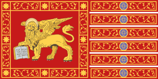
The Republic of Ragusa was an aristocratic maritime republic centered on the city of Dubrovnik in South Dalmatia that carried that name from 1358 until 1808. It reached its commercial peak in the 15th and the 16th centuries, before being conquered by Napoleon's French Empire and formally annexed by the Napoleonic Kingdom of Italy in 1808. It had a population of about 30,000 people, of whom 5,000 lived within the city walls. Its motto was "Non bene pro toto libertas venditur auro", a Latin phrase which can be translated as "Liberty is not well sold for all the gold".

<span class="mw-page-title-main">Pelješac Bridge</span> Cable-stayed bridge in Dubrovnik-Neretva County, Croatia

The Pelješac Bridge is a cable-stayed bridge in Dubrovnik-Neretva County, Croatia. The bridge provides a fixed link from the southeastern Croatian semi-exclave to the rest of the country while bypassing Bosnia and Herzegovina's short coastal strip at Neum. The bridge spans the sea channel between Komarna on the northern mainland and the peninsula of Pelješac, thereby passing entirely through Croatian territory and avoiding any border crossings with Bosnia and Herzegovina at Neum.

<span class="mw-page-title-main">Adriatic Highway</span> Coastal road in Southeastern Europe

The Adriatic Highway is a road that stretches along the eastern coast of the Adriatic Sea and is part of the European route E65. The road passes through Croatia, with smaller stretches through Bosnia and Herzegovina and Montenegro and ends at the Montenegro-Albania border. It is an undivided two-lane road for almost its entire length, with the exception of a short stretch through Zadar and a 24 kilometres (15 mi) dual-carriageway section from Plano (Trogir) to the southeast suburbs of Split. It was planned in the 1930s and built in the 50s and 60s. The dual carriageway is planned to be extended further southeast to Omiš. Completion of the Adriatic Ionian motorway is proposed in order to replace Adriatic Highway as a high-performance road transport route along the Adriatic coast.

<span class="mw-page-title-main">D8 road (Croatia)</span> Road in Croatia

The D8 state road is the Croatian section of the Adriatic Highway, running from the Slovenian border at Pasjak via Rijeka, Senj, Zadar, Šibenik, Split, Opuzen and Dubrovnik to the border with Montenegro at Karasovići. Most of the D8 state road remains single carriageway, though with some dual carriageway stretches. The total length of the road through Croatia is 643.1 kilometres (399.6 mi).

<span class="mw-page-title-main">Herzegovina</span> Historical region of Bosnia and Herzegovina

Herzegovina is the southern and smaller of two main geographical regions of Bosnia and Herzegovina, the other being Bosnia. It has never had strictly defined geographical, cultural or historical borders, nor has it ever been defined as an administrative whole in the geopolitical and economic subdivision of Bosnia and Herzegovina.

<span class="mw-page-title-main">Bosnia and Herzegovina–Croatia relations</span> Bilateral relations

The foreign relations between Bosnia and Herzegovina (BiH) and Croatia are bound together by shared history, language, neighboring geography and cultural commonalties. They established diplomatic relations in 1992, following the dissolution of Yugoslavia and independence of Croatia. The two countries share a 932-kilometer (579 mi) border – the second longest external land border in the European Union (EU). Modern relations between the two states are functional but remain tense after ineffective 21st-century attempts at détente.

<span class="mw-page-title-main">Bay of Mali Ston</span>

Bay of Mali Ston is a bay in the Adriatic Sea, enclosed by the Pelješac peninsula and the mainland. The name primarily refers to the innermost, eastern part of the bay, while the name Channel of Mali Ston is used for the channel between the peninsulas of Klek and Pelješac, in the west. The two bodies of water are located in Croatia's and partly in Bosnia and Herzegovina's territorial waters.

<span class="mw-page-title-main">Neum Agreement</span> 1998 unimplemented treaty between Croatia and Bosnia

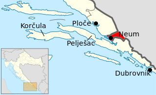
The Neum Agreement is an unimplemented treaty between Croatia and Bosnia and Herzegovina granting free passage of Croatian transit traffic between parts of the territory of Dubrovnik-Neretva County. So from the area around the city of Dubrovnik to the rest of the county, thus forming a pene-exclave within the Dubrovnik-Neretva County at the municipality of Neum.

<span class="mw-page-title-main">Klek (peninsula)</span> Peninsula of Bosnia and Herzegovina in Adriatic Sea

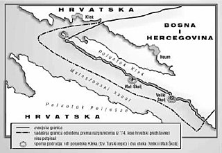
Klek is a peninsula in the Adriatic Sea located southwest of Neum, Bosnia and Herzegovina. It encloses the Bay of Neum, separating it from the larger Bay of Mali Ston and the Pelješac peninsula. At the cape of the peninsula, a few hundred meters from the shore, is a small islet as part of a reef consisting series of bare rocks appearing under the water table. It is called Lopata, and at the tip of the reef there is a lighthouse, also called Lopata. At the very tip of the peninsula, there is another lighthouse, called Rep Kleka.

<span class="mw-page-title-main">EV8 The Mediterranean Route</span> European cycling route

EuroVelo 8 (EV8), named the Mediterranean Route, is a 7,560 km (4,700 mi) long EuroVelo long-distance cycling route running from Cadiz, Spain to Athens, Greece, and then continuing to İzmir, Turkey and to the island of Cyprus. The route runs east-west across Europe mainly along or close to the Mediterranean coast, passing successively through 12 countries: Spain, France, Monaco, Italy, Slovenia, Croatia, Bosnia-Herzegovina, Montenegro, Albania, Greece, Turkey, and Cyprus.

<span class="mw-page-title-main">Venetian Dalmatia</span> Historical parts of Dalmatia under the rule of the Republic of Venice

Venetian Dalmatia refers to parts of Dalmatia under the rule of the Republic of Venice, mainly from the 15th to the 18th centuries. Dalmatia was first sold to Venice in 1409 but Venetian Dalmatia was not fully consolidated until 1420. It lasted until 1797, when the Republic of Venice fell to the forces of Napoleon Bonaparte and Habsburg Austria.

The Sutorina dispute was a border dispute between Montenegro and Bosnia and Herzegovina regarding the sovereignty over the territory of Sutorina. Since the Berlin Congress of 1878 the territory of Sutorina had been a part of Bosnia and Herzegovina within Austria-Hungary and later the Kingdom of Yugoslavia, but in the aftermath of World War II in 1947 it became part of SR Montenegro within FPR/SFR Yugoslavia. After the breakup of Yugoslavia, control of the territory was retained by Montenegro, but some Bosnian officials claimed that the territory transfer had been illegal, disputing Montenegrin sovereignty over the area. In 2015, the two countries reached an agreement which gave the sovereignty over the territory to Montenegro.

<span class="mw-page-title-main">Battle of Vukov Klanac</span>

The Battle of Vukov Klanac was a 7-day fight between Wehrmacht and Yugoslav Partisan forces in central Dalmatia. The battle occurred between 15 and 23 October 1944. It occurred in the region between Metković and Ston as Wehrmacht forces retreated from the nearby cities of Dubrovnik and Ston. It resulted in the 369th Devil's Division losing most of its equipment and a large fraction of its manpower to Partisan forces.

Bosansko Primorje,, is a historical coastal region on the eastern Adriatic shores, which between the beginning of the 14th and the end of the 17th century stretched from the Neretva river delta to Kuril area of Petrovo Selo, near today's Dubrovnik, above Mokošica in Rijeka Dubrovačka. This region is referred in historiography as the Bosansko Primorje, Bosnian Littoral or Bosnian Coast.

References

  1. "CIA - The World Factbook -- Field Listing - Coastline". 13 June 2007. Archived from the original on 13 June 2007. Retrieved 16 November 2023.
  2. Bosnia-and-Herzegovina Neum britannica.com, britannica.com, 2015-09-09
  3. UNEP / PAP/RAC / Ministarstvo spoljne trgovine i ekonomskih odnosa BiH. "4.1 Prijedlog za CAMP oblast". Program upravljanja obalnim područjem (CAMP) Bosne i Hercegovine (pdf) (Studija izvodljivosti ed.). ekonsultacije.gov.ba. Retrieved 6 November 2022.[ permanent dead link ]
  4. 1 2 "Naseljena Mjesta 1991/2013" (in Bosnian). Statistical Office of Bosnia and Herzegovina . Retrieved 10 October 2021.
  5. Jennings, Ken. "This Country's Coastline Is So Short, You Could Walk It in A Day". Condé Nast Traveler.
  6. "Why does Bosnia have a Coast?". 24 December 2018. Archived from the original on 14 August 2020. Retrieved 17 May 2020.
  7. Vego, Milan N. (1 July 1996). Austro-Hungarian Naval Policy, 1904-14. Frank Cass. ISBN   9780714642093 via Google Books.
  8. ""Neum i granični problemi", Poskok.info, December 14th, 2012". Archived from the original on 6 July 2018. Retrieved 28 October 2013.
  9. "Bridging gaps with EU-funds: The Inauguration of the Pelješac Bridge in Croatia".
  10. "50. Split Summer". Archived from the original on 10 June 2008. Retrieved 2 September 2008.
  11. Neum Animated Film Festival Archived 2008-09-16 at the Wayback Machine
  12. "Matica hrvatska". www.matica.hr.
  13. "HKD Napredak".[ permanent dead link ]

42°55′30″N17°37′00″E / 42.92500°N 17.61667°E / 42.92500; 17.61667