Disused railway stations on the Cornish Main Line

Last updated

Contents

Plymouth to Penzance
BSicon CONTg.svg
to Exeter St Davids
BSicon STR.svg
BSicon exKBHFa.svg
Plymouth (Millbay)
BSicon BHF.svg
BSicon exSTR.svg
0¾
Plymouth (North Road)
BSicon eABZgl+l.svg
BSicon exSTRr.svg
Cornwall Junction
BSicon eABZgl.svg
BSicon exCONTfq.svg
BSicon eHST.svg
½
Wingfield Villas Halt
BSicon HST.svg
1¾
Devonport
BSicon HST.svg
Dockyard
BSicon eHST.svg
Ford Halt
BSicon HST.svg
2¾
Keyham
BSicon CONTgq.svg
BSicon ABZgr.svg
BSicon HST.svg
St Budeaux Ferry Road
BSicon hbKRZWae.svg
BSicon HST.svg
4¾
Saltash
BSicon eHST.svg
Defiance Platform
BSicon eSHI2gl.svg
BSicon exBS2c3.svg
BSicon exSTR~L.svg
BSicon TUNNEL1.svg
BSicon exSTR~R.svg
1906 deviation
BSicon exSHI4c2.svg
BSicon lMKRZ3+1u.svg
BSicon exSTR3h+1h.svg
BSicon STR.svg
BSicon exSHI4c4.svg
BSicon exBS2c1.svg
BSicon eSHI2g+r.svg
BSicon HST.svg
9¾
St Germans
BSicon lhSTRa@f.svg
BSicon HST.svg
14½
Menheniot
BSicon 3STR+1.svg
BSicon 3KRZo-.svg
BSicon 3STR+4.svg
BSicon KRWgl.svg
BSicon KRWg+r.svg
BSicon STR.svg
BSicon HUBaq.svg
BSicon KHSTe.svg
BSicon HUBeq.svg
BSicon HST.svg
BSicon STR.svg
17½
Liskeard
BSicon STR+l.svg
BSicon lHST~L.svg
BSicon KRZo.svg
BSicon lHST~R.svg
BSicon ABZr+r.svg
Coombe Junction Halt
BSicon KBSTxe.svg
BSicon STR.svg
BSicon STR.svg
Moorswater
BSicon exCONTf.svg
BSicon STR.svg
BSicon CONTf.svg
BSicon eHST.svg
20¾
Doublebois
BSicon HST.svg
26½
Bodmin Parkway
BSicon CONTgq.svg
BSicon ABZgr.svg
Bodmin branch line
BSicon eHST.svg
Respryn
BSicon HST.svg
30¾
Lostwithiel
BSicon vABZg2-.svg
BSicon dSTRc3.svg
BSicon dSTR.svg
BSicon dSTRc1.svg
BSicon edHST+4.svg
Golant
BSicon STR.svg
BSicon KBSTxe.svg
Carne Point
BSicon TUNNEL2.svg
BSicon exHST.svg
Fowey
BSicon HST.svg
BSicon exTUNNEL1.svg
34½
Par
BSicon STRc2.svg
BSicon STRc2.svg
BSicon ABZg3.svg
BSicon ABZ3+lxg.svg
BSicon KDSTeq.svg
Par Harbour
BSicon STRc2.svg
BSicon STR+1.svg
BSicon STRc4.svg
BSicon KRZ3+1o.svg
BSicon STRc4.svg
BSicon exlHST~F.svg
BSicon ABZg+1.svg
BSicon STR+c4.svg
St Blazey
BSicon exlHST~G.svg
BSicon CONTf@F.svg
BSicon STR.svg
BSicon HST.svg
39¾
St Austell
BSicon exCONTgq.svg
BSicon eABZgr.svg
Lansalson branch line
BSicon eHST.svg
41½
BSicon CONTgq.svg
BSicon ABZgr.svg
BSicon eHST.svg
46¾
Grampound Road
BSicon eHST.svg
Probus and Ladock Halt
BSicon HST.svg
53½
Truro
BSicon dTUNNEL2.svg
BSicon exdKHSTa.svg
Truro (Newham)
BSicon exSTR~L.svg
BSicon ABZgl.svg
BSicon exSTR~R.svg
BSicon CONTfq.svg
BSicon eSHI2g+l.svg
BSicon exBS2c4.svg
Penwithers Junction
BSicon eHST.svg
58¾
Chacewater
BSicon exCONTgq.svg
BSicon eABZgr+r.svg
BSicon eHST.svg
60½
Scorrier
BSicon exKHST2.svg
BSicon exSTRc3.svg
BSicon HST.svg
62½
Redruth
BSicon exSTRc1.svg
BSicon eABZg+l.svg
BSicon exSTR+4.svg
BSicon exKBSTeq.svg
Tresavean branch line
BSicon exKBSTaq.svg
BSicon eABZg+r.svg
Portreath branch line
BSicon eHST.svg
63¾
Carn Brea
BSicon exKBSTaq.svg
BSicon eABZgr.svg
North Crofty
BSicon eHST.svg
65½
Dolcoath Halt
BSicon HST.svg
66¼
Camborne
BSicon eHST.svg
Penponds
BSicon eABZg+l.svg
BSicon exCONTfq.svg
BSicon eHST.svg
68¾
Gwinear Road
BSicon exdSTRc2.svg
BSicon ev-ABZg3.svg
BSicon exdSTR+1.svg
BSicon exdSTRc4.svg
BSicon edHST.svg
70¼
Angarrack
BSicon exSTR.svg
BSicon eHST.svg
71¾
Copperhouse Halt
BSicon exKBSTe.svg
BSicon HST.svg
72¾
Hayle
BSicon CONTgq.svg
BSicon ABZg+r.svg
BSicon HST.svg
73¾
St Erth
BSicon eHST.svg
77½
Marazion
BSicon KBHFe.svg
79¼
Penzance

There are seventeen disused railway stations on the Cornish Main Line between Plymouth in Devon and Penzance in Cornwall, England. The remains of nine of these can be seen from passing trains. While a number of these were closed following the so-called "Beeching Axe" in the 1960s, many of them had been closed much earlier, the traffic for which they had been built failing to materialise.

Background

The railway from Plymouth to Truro was opened by the Cornwall Railway on 4 May 1859, where it joined up with the West Cornwall Railway which had been completed from there to Penzance on 16 April 1855. The section from Carn Brea to Angarrack dates back to the Hayle Railway, opened on 23 December 1837. It now forms Network Rail's Cornish Main Line.

Plymouth to Truro

Plymouth Millbay

The trains of the South Devon Railway finally reached the town of Plymouth on 2 April 1849. Docks were opened adjacent to the station and a new headquarters office was built next door. The station was expanded ready for the opening of the Cornwall Railway on 4 May 1859 and the South Devon and Tavistock Railway on 22 June 1859. It became known as Plymouth Millbay after other stations were opened in the town in 1876–7 at Mutley and North Road.

The station was closed to passengers on 23 April 1941 after bombs destroyed the nearby goods depot; the passenger station being used thereafter only for goods traffic and access to the carriage sheds. All traffic ceased from 14 December 1969 except for goods trains running through to the docks which continued until 30 June 1971.

The site is now occupied by the Plymouth Pavilions leisure complex. Two granite gate posts outside the Millbay Road entrance are all that is left of the station, although a goods shed on what used to be Washington Place is still extant nearby

Wingfield Villas Halt

This suburban halt ( 50°22′41″N4°09′28″W / 50.3781°N 4.1579°W / 50.3781; -4.1579 (Wingfield Villas Halt) ) near Devonport Junction in Plymouth was opened by the Great Western Railway on 1 June 1904. It was served by the Plympton to Saltash railmotor service introduced at that time to compete with the electric tramways in the town. It was closed in June 1921.

Ford Halt

Ford ( 50°23′08″N4°10′39″W / 50.3856°N 4.1776°W / 50.3856; -4.1776 (Ford Halt) ) [1] was one of the halts opened by the Great Western Railway for its railmotor services on 1 June 1904. It was located to serve the northern district of Devonport which had grown around the naval dockyard; other stations serving this traffic were opened at Keyham (1900) and Dockyard Halt (1905). The denuded remains of the southbound platform still remain, just west of an underbridge into the Royal Navy Dockyard and at the commencement of the cutting before Keyham.

It was closed on 6 October 1941, [2] during the World War II blitz of Plymouth and Devonport.

Defiance Platform

Old entrance to Defiance Platform Defiance platform 2009.jpg
Old entrance to Defiance Platform

Defiance Platform ( 50°23′53″N4°13′08″W / 50.3981°N 4.2188°W / 50.3981; -4.2188 (Defiance Platform) ) (252  miles 11  chains or 405.8 km) [3] was opened by the Great Western Railway on 1 March 1905 and served naval personnel travelling to the nearby torpedo training school on HMS Defiance which was moored nearby. Most trains were the railmotors and auto trains from Plympton which were run for an extra 34 mile (1.2 km) beyond Saltash where they otherwise terminated.

The line was doubled and moved on 4 February 1906 and Wearde became the junction for a deviation line to St Germans that allowed the removal of the remaining timber viaducts on the Cornish Main Line. As a result of the deviation the platform was moved in 1907, [4] where access to the platform was by steps from a bridge that carried a road across the railway to Wearde Quay. The signal box that had been at the original location was also relocated and was situated at one end of the platform.

The station closed to passengers on 27 October 1930 but continued to be used for loading goods traffic until the 1950s. [5] The platforms are still in existence and alterations to the road bridge to accommodate the new alignment of 1906 can be clearly seen. The old line was retained as carriage sidings for Saltash until 2 December 1964 and another siding behind the platform was kept in use until 1972.

Doublebois

A 1905 Railway Clearing House Junction Diagram showing (lower right) railways in the vicinity of Doublebois Bromshall, Clifton (Molyneux), Hay, Liskeard, Patricroft & Uttoxeter RJD 148.jpg
A 1905 Railway Clearing House Junction Diagram showing (lower right) railways in the vicinity of Doublebois

Doublebois station (Cornish : Kosdewblek) ( 50°27′21″N4°32′17″W / 50.4558°N 4.5381°W / 50.4558; -4.5381 (Doublebois railway station) ) (268  miles 14  chains or 431.59 kilometres) [3] was situated at the west end of a cutting [6] which is the summit of the Cornwall Railway. A siding was provided here when it opened on 4 May 1859 to enable trains to be split into smaller parts to enable them to be worked over the steep inclines up from Liskeard and Bodmin Road.

In January 1860 the railway company was asked to provide a facility here for goods traffic, which they acceded to after local people subscribed £130 towards it and offered the necessary land. Because of this the company offered to build an accompanying passenger station. The station opened on 1 June 1860, providing a service to people and mines in the St Neot area, providing a passing loop until the line was doubled in 1894. A signal box was provided part way along the platform, with sidings at both ends on the down side. During World War II, the eastern sidings were used by the military for ammunition. [7]

The station was closed on 5 October 1964, and the sidings were taken out of use in January 1968. [7] Extant earthworks are still visible from passing trains.

Respryn

Due to delays in securing the site for Bodmin Road, the Cornwall Railway provided a temporary station a little further west for the opening of the line on 4 May 1859 until the permanent station was ready on 27 June 1859.

Burngullow

Once it was open, the Cornwall Railway found there was a demand for facilities to transport china clay from the St Stephens district to Par harbour. To satisfy this they opened a station consisting of a single platform at Burngullow (Cornish : Bronnwolow) ( 50°20′11″N4°50′17″W / 50.3364°N 4.8381°W / 50.3364; -4.8381 (Burngullow railway station) ) (288  miles 45  chains or 464.40 kilometres) [8] on 1 February 1863. The construction costs were largely met by Mr Robartes, who had interests in the extraction of the china clay.

A branch line to Nanpean was opened for goods traffic by the Newquay and Cornwall Junction Railway on 1 July 1869. A small engine shed was built by them on the north side of the station. The shed closed in 1922 and was removed in 1931. [9]

The station was closed and rebuilt a little further west (288  miles 56  chains or 464.62 kilometres) [3] on 1 August 1901, this time with two platforms, and closed to passengers on 14 September 1931. The sidings and branch continue to handle heavy china clay traffic.

The large dryer and storage sheds alongside the main line are the Blackpool clay works; Burngullow clay works are smaller and situated alongside the branch line a short distance from the junction.

Two railway accidents have happened here, both involving runaway china clay trains. On the first occasion a train had left Burngullow with wagons for Par harbour on 29 October 1872. It was unable to stop for signals at St Austell but the driver of the passenger train coming in the other direction saw the train sliding towards it and reversed his train back to Par.

On 9 June 1952 a similar problem occurred with a train on the branch line approaching Burngullow. This time the train ran into a siding where it collided with a stationary engine. Unfortunately the driver of the runaway train, who had stayed at the controls in an attempt to bring it to a halt, later died from his injuries.

The former 'up side' (London bound) station building still remains some seventy years plus after closure.

The signal box was closed in 1986 when the Burngullow to Probus section of the main line was singled, and the signals were then controlled by the Signal Box at Par railway station. The double line was reinstated in 2004.

Grampound Road

New houses have been built at Grampound Road since the station closed. The Railway Line through Grampound Road - geograph.org.uk - 200286.jpg
New houses have been built at Grampound Road since the station closed.

A two-platform station ( 50°19′04″N4°55′43″W / 50.3177°N 4.9287°W / 50.3177; -4.9287 (Grampound Road railway station) ) (293  miles 16  chains or 471.86 kilometres) [3] to serve Grampound was opened in a cutting by the Cornwall Railway on 4 May 1859, but it was known as "Grampound Road" due to the distance from that town. Wooden waiting shelters were provided on each platform, [10] and a newspaper at the time of opening reported merely that "it comprises arrival and departure stations exactly similar to those at Par."

There was a loop on the up line at the down end of the station with a trailing crossover. [10] A goods shed was not provided until 1864 when one was erected in the up yard, [11] but with up and down yards the goods traffic developed quickly: 3,580 cattle were dispatched in the twelve months to June 1869, more than any other station on the line. A signal box was erected half way along the up platform of brick with a timber upper floor and slate roof.

Because of its remote location two cottages were built in 1860 for the station master and his staff. A small village known as Grampound Road (Cornish : Fordh Ponsmeur) grew up around the railway station and continues to expand despite the station's closing (along with Doublebois, Chacewater, Scorrier, Gwinear Road and Marazion) on 5 October 1964, but the signal box remained open until June 1972. [11] Harry Hingston was the last registered paid employee and station master.

The site is easily recognised from passing trains.

Probus and Ladock Halt

The Probus and Ladock halt (Cornish : Lannbrobus hag Egloslajek) ( 50°17′42″N4°58′07″W / 50.2950°N 4.9686°W / 50.2950; -4.9686 (Probus and Ladock Halt) ) (295  miles 47  chains or 475.70 kilometres) [3] was nearer to Probus than Ladock which was actually nearer to Grampound Road railway station and was opened by the Great Western Railway on 1 February 1908 as Probus and Ladock Platform, the term platform being used rather than Halt to indicate that it was staffed [12] although it was later changed to an unstaffed halt. Platforms were provided on both sides of the track of mixed timber and brick construction with access to each platform directly by a footpath from the road, and a foot crossing at rail level as there was no footbridge. [13] Characteristic Great Western Railway corrugated iron waiting shelters were provided on both of the wooden platforms at opening and remained in use throughout, and there was a signal box at the down end of the down platform. The station was closed on 2 December 1957, and by the early 1990s there was no trace of the down platform, but the section of the up platform that was built of brick was identifiable as a grassy mound with a signalling relay room on top. [13]

Truro to Penzance

Chacewater

Chacewater railway station in 2008 Chacewater railway station in 2008.jpg
Chacewater railway station in 2008

A station ( 50°15′50″N5°10′11″W / 50.2638°N 5.1698°W / 50.2638; -5.1698 (Chacewater railway station) ) (306  miles 1  chain or 492.48 kilometres) [3] was opened at Chacewater (Cornish : Dowr an Chas) by the West Cornwall Railway on 25 August 1852. On 6 July 1903 a branch line to Perranporth was opened from nearby Blackwater; it was extended to Newquay on 2 January 1905. Blackwater Junction was closed on 9 November 1924 which resulted in the physical junction being moved the half mile to Chacewater station, although most trains ran through to Truro.

The Perranporth line closed on 4 February 1963. The station closed to passengers on 5 October 1964 but continued to be served by goods traffic for many years, latterly for Blue Circle Cement. The Penzance bound platforms can still be seen, complete with much altered station building.

There are two viaducts east of Chacewater. The 128 yard (181 m) Blackwater Viaduct is immediately east of the station site and the 93 yard (132 m) Chacewater Viaduct is a little further east towards Truro. [14] [15]

Preceding station Historical railways Following station
Truro   Great Western Railway
Cornish Main Line
  Redruth
  Great Western Railway
Truro & Newquay
  Mount Hawke Halt

Scorrier

A station ( 50°15′11″N5°11′47″W / 50.2531°N 5.1964°W / 50.2531; -5.1964 (Scorrier railway station) ) (307  miles 57  chains or 495.22 kilometres) [3] was opened at Scorrier (Cornish : Skorya) by the West Cornwall Railway on 25 August 1852. Initially known as "Scorrier Gate", the name was changed to "Scorrier" in March 1856. It reverted to "Scorrier Gate" from 1 June 1859 but became plain "Scorrier" once more on 1 October 1896. Originally stone-built waiting rooms were erected on both platforms, each with a cantilever canopy, but at some stage an additional wooden building was erected on the down platform more than doubling the accommodation. The platforms were connected by an open footbridge of metal construction. [16]

The last trains to call at Scorrier were on 3 October 1964. Class 118 DMUs W51309 and W51324 formed the last down train, and W51304 and W51319 the last up train. It closed to passengers on 5 October 1964. [16]

Preceding station Disused railways Following station
Redruth   Great Western Railway
Cornish Main Line
  Chacewater

Carn Brea

A station ( 50°13′17″N5°16′02″W / 50.2213°N 5.2672°W / 50.2213; -5.2672 (Carn Brea railway station) ) (311  miles 70  chains or 501.91 kilometres) [3] was opened near Carn Brea (Cornish : Karnbre) on 23 May 1843 by the Hayle Railway and named "Pool" after a nearby village. The railway was closed on 16 February 1852 and reopened by the West Cornwall Railway on 11 March 1852, however Pool station remained closed until 25 August 1852, when it was reopened as "Carn Brea", only to be renamed "Pool" once more in June 1854. It reverted to "Carn Brea" on 1 November 1875. It was closed on 2 January 1961.

Carn Brea was the home of the West Cornwall Railway's workshops, where they maintained the locomotives and rolling stock.

Preceding station Disused railways Following station
Camborne   Great Western Railway
Cornish Main Line
  Redruth

Dolcoath Halt

The Great Western Railway opened a railmotor halt ( 50°12′51″N5°17′01″W / 50.2142°N 5.2837°W / 50.2142; -5.2837 (Dolcoath Halt) ) (312  miles 62  chains or 503.36 kilometres) [3] near Dolcoath mine on 28 August 1905 but it closed again on 1 May 1908; the days when Dolcoath was one of the biggest mines in Cornwall were long past. The halt was situated to the west of Dolcoath level crossing, and the site can be recognised because of this.

Penponds

The Hayle Railway provided a station at Penponds (Cornish : Pennpons) from 23 May 1843 until 16 February 1852. It was not replaced when the West Cornwall Railway opened a month later.

Gwinear Road

A station known as "Gwinear Road" (Cornish : Fordh Gwynnyer) ( 50°11′50″N5°20′52″W / 50.1972°N 5.3478°W / 50.1972; -5.3478 (Gwinear Road railway station) ) (316  miles 0  chains or 508.55 kilometres) [3] was opened by the West Cornwall Railway on 11 March 1852, west of a level crossing, and became a junction for the Helston Railway on 9 May 1887. The goods yard lay west of the station to the north of the line, but extensive sidings were constructed alongside the main line east of the level crossing to handle traffic for the branch. The main station building was of wooden construction and was located on the up platform with just a canopy on the down platform, the two platforms being connected by a footbridge of cast metal construction and utilitarian appearance. There were also two signalboxes at Gwinear Road: Gwinear Road West Signal Box, located on the up end of the down platform, opened on 30 November 1916 and was closed on 31 October 1965 when the adjacent level crossing was converted from manual gates to Automatic Half Barriers. [17] Gwinear Road East Signal Box was located in the goods marshalling yard and controlled access to the Helston branch.

The branch line to Helston closed to passengers on 3 September 1962 and to goods on 5 October 1964 when Gwinear Road station also closed. The former 'down' (Penzance-bound) platform and Helston branch bay is still more or less intact.

Preceding station Disused railways Following station
Hayle   Great Western Railway
Cornish Main Line
  Camborne
Terminus  Great Western Railway
Helston Railway
  Praze

Angarrack

The Hayle Railway introduced passenger trains on 23 May 1843. The service was closed on 16 February 1852. On 11 March 1852 the West Cornwall Railway opened a new station. The old station had been on the section of the Hayle Railway that was closed entirely as a steep rope-worked incline descended from Angarrack (Cornish : An Garrek) to sea level at Copperhouse, it was replaced by a much gentler incline to the new Hayle railway station. However the new Angarrack station was closed in 1853. (See also Angarrack viaduct.)

Copperhouse Halt

The Great Western Railway introduced railmotor services in west Cornwall and provided several small halts at which they called. Copperhouse (Cornish : Chi Kober) ( 50°11′22″N5°24′25″W / 50.1894°N 5.4070°W / 50.1894; -5.4070 (Copperhouse Halt) ) was one of the small halts provided for these services, opening on 1 July 1905 to provide a service to the Copperhouse district in Hayle. It closed in 1908.

An earlier station had been provided at Copperhouse nearer the waterfront by the Hayle Railway from 23 May 1843 until their line closed on 16 February 1852.

Marazion

43189 passes the disused Marazion station in 2007 Marazion station 43189.jpg
43189 passes the disused Marazion station in 2007

A station ( 50°07′45″N5°29′31″W / 50.1292°N 5.4919°W / 50.1292; -5.4919 (Marazion railway station) ) (324  miles 53  chains or 522.49 kilometres) [3] was opened at Marazion (Cornish : Marghasyow) by the West Cornwall Railway on 11 March 1852. New waiting rooms with corrugated iron pent roofs were completed in December 1878 or January 1879. [18] The original single platform was situated on the south side of the line but the station was rebuilt about thirty years later, when a second platform was added. The line westwards to Penzance was doubled in 1893 and the goods yard expanded so that it could share in handling the large volume of perishable traffic – fish, fruit and vegetables – from the surrounding farms and harbours. The line eastwards to St Erth was not doubled until 1929. The station closed for passengers on 5 October 1964.

The station is situated on the shore of Mount's Bay with fine views of St Michael's Mount and for many years was home to six old Pullman coaches that were formerly used as camping coaches. Three of these were rescued and restored, and now provide sleeping accommodation at Petworth railway station, which has been converted into a guest house. One was purchased privately, while the others were left to become derelict until broken up on site. [19] In 2006 the remains of these coaches was cleared away from the site to make way for nine holiday cottages, the old station has now been fully restored into a two bedroom bungalow currently owned by the developers.[ citation needed ] The 1880s station building still stands, but part of the line westwards is currently reduced to a single track.

Preceding station Historical railways Following station
Penzance   Great Western Railway
Cornish Main Line
  St Erth

See also

Disused railway stations (Exeter to Plymouth Line)

Related Research Articles

<span class="mw-page-title-main">Bodmin and Wenford Railway</span> Heritage railway in Cornwall, England

The Bodmin and Wenford Railway is a 6 miles 12 chains (9.9 km) heritage railway at Bodmin in Cornwall, England. Its headquarters are at Bodmin General railway station and it connects with the national rail network at Bodmin Parkway.

<span class="mw-page-title-main">Chacewater</span> Village and civil parish in Cornwall, England, UK

Chacewater is a village and civil parish in Cornwall, England, UK. It is situated approximately 3 miles (4.8 km) east of Redruth. The hamlets of Carnhot, Cox Hill, Creegbrawse, Hale Mills, Jolly's Bottom, Salem, Saveock, Scorrier, Todpool, Twelveheads and Wheal Busy are in the parish. The electoral ward is called Chacewater & Kenwyn. At the 2011 census a population of 3,870 was quoted.

<span class="mw-page-title-main">Par railway station</span> Railway station in Cornwall, England

Par railway station serves the villages of Par, Tywardreath and St Blazey, Cornwall, England. The station is 281 miles 66 chains from the zero point at London Paddington measured via Box and Plymouth Millbay. It is the junction for the Atlantic Coast Line to Newquay.

<span class="mw-page-title-main">Redruth railway station</span> Railway station in Cornwall, England

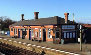
Redruth station serves the town of Redruth, Cornwall, United Kingdom, and is situated on the Cornish Main Line between Truro and Camborne. The station is 309 miles 68 chains from the zero point at London Paddington measured via Box and Plymouth Millbay.

<span class="mw-page-title-main">Camborne railway station</span> Railway station in Cornwall, England

Camborne railway station serves the town of Camborne, Cornwall, England. The station is 313 miles 40 chains from the zero point at London Paddington measured via Box and Plymouth Millbay.

<span class="mw-page-title-main">Hayle railway station</span> Railway station in Cornwall, England

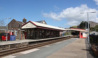
Hayle railway station serves the small town of Hayle, Cornwall, United Kingdom. Great Western Railway manage the station and operate most train services.

<span class="mw-page-title-main">St Erth railway station</span> Railway station in Cornwall, England

St Erth railway station is a Grade II listed station situated at Rose-an-Grouse in Cornwall, United Kingdom. It serves the nearby village of St Erth, which is about 0.75 miles (1.21 km) away, and is the junction for the St Ives Bay Line to St Ives. The station is 320 miles 78 chains from the zero point at London Paddington measured via Box and Plymouth Millbay.

<span class="mw-page-title-main">Angarrack</span> Human settlement in England

Angarrack is a village in west Cornwall, England, UK. It is in the parish of Gwinear-Gwithian a mile to the east of Hayle. Immediately south of the village Angarrack viaduct carries the Cornish mainline railway over the Angarrack River. The name comes from An Garrek which means "The Rock" in the Cornish language. According to the Ordnance Survey the spelling is Angarrack but on signs near the village, it is variously spelled Angarrack, Angharrack, or Angarrick.

The West Cornwall Railway was a railway company in Cornwall, Great Britain, formed in 1846 to construct a railway between Penzance and Truro. It purchased the existing Hayle Railway, and improved its main line, and built new sections between Penzance and Hayle, and between Redruth and Truro, and opened throughout in 1852.

St Dennis Junction was in St Dennis, Cornwall.

<span class="mw-page-title-main">Hayle Railway</span>

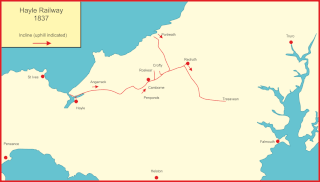
The Hayle Railway was an early railway in West Cornwall, constructed to convey copper and tin ore from the Redruth and Camborne areas to sea ports at Hayle and Portreath. It was opened in 1837, and carried passengers on its main line from 1843.

<span class="mw-page-title-main">Cornish Main Line</span> Railway line in Cornwall, England

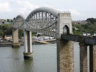
The Cornish Main Line is a railway line in Cornwall and Devon in the United Kingdom. It runs from Penzance to Plymouth, crossing from Cornwall into Devon over the famous Royal Albert Bridge at Saltash.

<span class="mw-page-title-main">North Cornwall Railway</span> Disused railway line in Devon and Cornwall, England

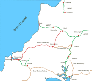
The North Cornwall Railway was a railway line running from Halwill in Devon to Padstow in Cornwall via Launceston, Camelford and Wadebridge, a distance of 49 miles 67 chains. Opened in the last decade of the nineteenth century, it was part of a drive by the London and South Western Railway (LSWR) to develop holiday traffic to Cornwall. The LSWR had opened a line connecting Exeter with Holsworthy in 1879, and by encouraging the North Cornwall Railway it planned to create railway access to previously inaccessible parts of the northern coastal area.

<span class="mw-page-title-main">Disused railway stations on the Exeter to Plymouth Line</span>

There are eleven disused railway stations on the Exeter to Plymouth line between Exeter St Davids and Plymouth Millbay in Devon, England. At eight of these there are visible remains.

There are eight disused railway stations between Wadebridge and Bodmin North on the former Bodmin and Wadebridge Railway in Cornwall, in the United Kingdom, with ten other closed sidings on the branches to Ruthern Bridge and Wenfordbridge. The section from Boscarne Junction to Bodmin General is currently part of the Bodmin and Wenford Steam Railway; the line from Wadebridge to Wenfordbridge is now part of the Camel Trail, and the line to Ruthern Bridge can be followed for much of its length as it runs parallel to a public road.

The Truro and Newquay Railway was a Great Western Railway line in Cornwall, England, designed to keep the rival London and South Western Railway (LSWR) out of the west of the county. The line was completed in 1905 and closed in 1963.

<span class="mw-page-title-main">Helston Railway</span> Former branch line in Cornwall, England, now a heritage railway

The Helston Railway is a heritage railway in Cornwall which aims to rebuild and preserve as much as possible of the former GWR Helston Railway between Nancegollen and Water-Ma-Trout on the outskirts of Helston. It is operated by the Helston Railway Preservation Company using members of the Helston Railway Preservation Society.

<span class="mw-page-title-main">Hayles Abbey Halt railway station</span> Former railway station in England

Hayles Abbey Halt railway station is a halt opened by the Great Western Railway on the Honeybourne Line from Honeybourne to Cheltenham which served the hamlet of Hailes in Gloucestershire, as well as the nearby Hailes Abbey, between 1928 and 1960. The line through the site of the station was reinstated in 1985 and opened in 1987 by the Gloucestershire Warwickshire Railway, although for many years no new halt was provided. The halt was eventually reopened on 5 June 2017 after being rebuilt by volunteers. Unlike the original, however, it only has a single platform. It lies between Toddington and Winchcombe stations.

The Yeovil–Taunton line was a railway line in England, built by the Bristol and Exeter Railway (B&ER) to connect its main line with the market town of Yeovil in Somerset. It opened in 1853 using the broad gauge of 7 ft 14 in and was the first railway to serve Yeovil. It ran from a junction at Durston although in later years passenger trains on the line ran through to and from Taunton where better main and branch line connections could be made.

<span class="mw-page-title-main">Nancegollan railway station</span> Former railway station in England

Nancegollan railway station located in Nancegollan, Cornwall served an important agricultural district and was also the railhead for the fishing port of Porthleven.

References

  1. "Ford Halt". Old Devonport. Retrieved 16 January 2021.
  2. Railway Passenger Stations by M.Quick page 106
  3. 1 2 3 4 5 6 7 8 9 10 11 Oakley, Michael (1981), "135 Paddington and Bristol to Penzance", Wessex and West Country, Diesel Enthusiast's Pocket Guide, vol. 8, Truro: D Bradford Barton, ISBN   0-85153-409-0
  4. Vaughan 2009, p. 31.
  5. Railway Passengers Stations by M. Quick page 157
  6. Pike, Stuart Nelson (2011). Mile by Mile on Britain's Railways. London: Aurum Press. p. 127. ISBN   978-1-84513-612-3.
  7. 1 2 Vaughan 2009, p. 50.
  8. Vaughan 2009, p. 98.
  9. Vaughan 2009, p. 99.
  10. 1 2 Heginbotham 2010, pp. 22–26.
  11. 1 2 Vaughan 2009, p. 100.
  12. Vaughan 2009, p. 101.
  13. 1 2 Mitchell 1994, p. 110.
  14. Ordnance Survey: Landranger map sheet 204 Truro & Falmouth ISBN   9780319231494
  15. Binding, John (1993). Brunel's Cornish Viaducts. Atlantic Transport Publishing. pp. 106/4. ISBN   0-90689-956-7.
  16. 1 2 Heginbotham 2010, pp. 36–37.
  17. Heginbotham 2010, pp. 42–45.
  18. "Marazion". The Cornishman. No. 22. 12 December 1878. p. 5.
  19. Abandoned lines and railways – Marazion (includes pictures of station and coaches) Accessed 05 Jun 2007

Sources