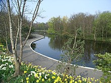
Dodder Park is a suburban linear park in Dublin, Ireland, consisting of over 100 hectares of fragmented parkland and remnant countryside. [1]
Dodder Park is a suburban linear park in Dublin, Ireland, consisting of over 100 hectares of fragmented parkland and remnant countryside. [1]
The park is located in Rathfarnham, Rathgar and Milltown. It is named after the River Dodder, which flows through it.
There is angling on the River Dodder for members of the Dodder Angling Association. Anglers come to Ireland every year to fish the river. It is also a haven for wildlife: among the species to be seen are kingfisher, dipper, grey heron, sparrowhawk, and fox.

Dublin Bay is a C-shaped inlet of the Irish Sea on the east coast of Ireland. The bay is about 10 kilometres wide along its north–south base, and 7 km in length to its apex at the centre of the city of Dublin; stretching from Howth Head in the north to Dalkey Point in the south. North Bull Island is situated in the northwest part of the bay, where one of two major inshore sand banks lay, and features a 5 km long sandy beach, Dollymount Strand, fronting an internationally recognised wildfowl reserve. Many of the rivers of Dublin reach the Irish Sea at Dublin Bay: the River Liffey, with the River Dodder flow received less than 1 km inland, River Tolka, and various smaller rivers and streams.

The River Dargle is a river that flows from the Wicklow Mountains in Ireland to the Irish Sea. It forms Powerscourt Waterfall, receives the Glencree and Glencullen Rivers, and later the Glenmunder Stream / County Brook, and the Swan River at Bray, and reaches the sea at Bray Harbour.

Templeogue is a southwestern suburb of Dublin in Ireland. It lies between the River Poddle and River Dodder, and is about halfway from Dublin's centre to the mountains to the south.

Knocklyon is a suburb of Dublin in county of South Dublin, within the old County Dublin, Ireland. Unlike many Dublin suburbs, Knocklyon was not developed around a village; rather it largely comprises modern housing built between the village of Templeogue and the former hamlet, now a suburb in its own right, of Firhouse. A number of old cottages and farmhouses along Knocklyon Road attest to the area's rural past.

Ringsend is a southside inner suburb of Dublin, Ireland. It is located on the south bank of the River Liffey and east of the River Dodder, about two kilometres east of the city centre. It is the southern terminus of the East Link Toll Bridge. Areas included in Ringsend are the south side of the Dublin Docklands, and at the west end is the area of South Lotts and part of the Grand Canal Dock area. Neighbouring areas include Irishtown, Sandymount and the Beggars Bush part of Ballsbridge to the south, and the city centre to the west. A key feature of the area is the chimneys of Poolbeg power station.

The River Dodder is one of the three main rivers in Dublin, Ireland, the others being the Liffey, of which the Dodder is the largest tributary, and the Tolka.
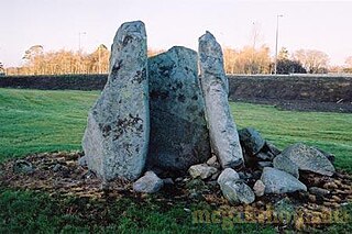
Brehon's Chair, sometimes Druid's Chair, is a megalithic site, and national monument, in Whitechurch, Rathfarnham, Dún Laoghaire–Rathdown, County Dublin, Ireland.

Danesmoate House is a Georgian house in the greater Rathfarnham area of County Dublin, Ireland.

Milltown is a suburb on the southside of Dublin, Ireland. Milltown was the site of several working mills on the River Dodder and is also the location of the meeting of the River Slang with the Dodder. It is located adjacent to other suburban areas such as Windy Arbour, Ranelagh, Dartry, Clonskeagh, and Donnybrook.

The River Tolka, also once spelled Tolga, is one of Dublin's three main rivers, flowing from County Meath to Fingal within the old County Dublin, and through the north of Dublin city, Ireland. By flow of water, the Tolka is the second largest river in Dublin, following the Liffey, but runs more slowly than the Dodder.
Beggars Bush is the site of the former Beggars Bush Barracks on Haddington Road in the inner southern suburbs of Dublin, Ireland, as well the surrounding area and a nearby pub. The barracks were bordered to the east by Shelbourne Road, which used to be the western bank of the River Dodder. The locality is in the jurisdiction of Dublin City Council, is broadly considered to be part of Ballsbridge, and is in the postal district Dublin 4.

The River Poddle is a river in Dublin, Ireland, a pool which gave the city its English language name. Boosted by a channel made by the Abbey of St. Thomas à Becket, taking water from the far larger River Dodder, the Poddle was the main source of drinking water for the city for more than 500 years, from the 1240s. The Poddle, which flows wholly within the traditional County Dublin, is one of around a hundred members of the River Liffey system, and one of over 135 watercourses in the county; it has just one significant natural tributary, the Commons Water from Crumlin.

Palmerston Park is a public park and residential area in Dartry, a suburb of Dublin, Ireland.
Bushy Park is a large, 20.5-hectare (51-acre), suburban public park in Terenure, Dublin, Ireland.

Oldbawn is a small suburban area now within Tallaght on Dublin's southside. Formerly a small village in its own right, it is situated between Sean Walsh Park and the River Dodder.

Britain Quay is a street and quay in Dublin on the south bank of the River Liffey between Sir John Rogerson's Quay and the confluence of the River Liffey, River Dodder and Grand Canal.

The R112 road is a regional road in south Dublin, Ireland. It begins at the junction with the R148 road at Chapelizod and arcs southeastwards, then eastwards across the middle of south Dublin, ending at the Mount Merrion junction of the R138. The road is a single carriageway, with cycle lanes on some stretches. Improvements to the road have been made over the last 10 years, the most significant being at Dundrum Cross where the road was widened to make room for the new Luas bridge and Dundrum bypass.
Seefingan often spelt Seafingan is a mountain that straddles two county boundaries from its summit in Wicklow eastwards down into South Dublin, in Ireland. There are extensive views from the summit and there is a large megalithic cairn nearby.
The Owendoher River is a small river in southern County Dublin, Ireland, the largest tributary of the River Dodder, and a part of the River Liffey system.
The Lyreen River is a small river in County Kildare, Ireland, a tributary of the Rye River (Ryewater), and ultimately of the River Liffey.