Doolbi, Queensland

Last updated

Doolbi
Queensland
Australia Queensland location map.svg
Red pog.svg
Doolbi
Coordinates 25°13′49″S152°18′14″E / 25.2302°S 152.3038°E / -25.2302; 152.3038 (Doolbi (centre of locality)) Coordinates: 25°13′49″S152°18′14″E / 25.2302°S 152.3038°E / -25.2302; 152.3038 (Doolbi (centre of locality))
Population115 (2016 census) [1]
 • Density20.18/km2 (52.3/sq mi)
Postcode(s) 4660
Area5.7 km2 (2.2 sq mi)
Time zone AEST (UTC+10:00)
Location
LGA(s) Bundaberg Region
State electorate(s) Burnett
Federal Division(s) Hinkler
Suburbs around Doolbi:
Childers North Isis Horton
Childers Doolbi Horton
Childers South Isis Horton
Doolbi Sugar Mill, 1914 Doolbi Sugar Mill, 1914.JPG
Doolbi Sugar Mill, 1914
Loading juice tankers at Doolbi Sugar Mill near Childers, 1899 Loading juice tankers at Doolbi Sugar Mill near Childers, 1899.tiff
Loading juice tankers at Doolbi Sugar Mill near Childers, 1899
Sugar cane juice train from Doolbi to Yengarie, early 1890s Sugar cane juice train Doolbi to Yengarie Queensland, early 1890s.tiff
Sugar cane juice train from Doolbi to Yengarie, early 1890s

Doolbi is a rural locality in the Bundaberg Region, Queensland, Australia. [2] In the 2016 census, Doolbi had a population of 115 people. [1]

Contents

Geography

Located just to the east of the town of Childers, Doolbi is bordered to the south by the Bruce Highway. The land in Doolbi is almost entirely used for farming with a small area of residential housing and the Isis Golf Course in the centre of the locality; there is no commercial development. [3]

History

In 1890 the first sugar cane crushing mill in the Isis district was established at Doolbi. The mill produced juice, which was then taken to Yengarie for processing into sugar. In 1900, the Doolbi mill was upgraded to produce sugar. As more sugar mills opened in the district, there was not enough cane to keep them all profitable and the Doolbi mill closed in 1924. The mill was in the south-western corner of the present Isis Golf Course ( 25°13′52″S152°18′00″E / 25.231°S 152.300°E / -25.231; 152.300 (Doolbi sugar mill) ) and an old brick chimney is still visible. [4]

Horton State School opened circa 1888. In 1900 it was renamed Doolbi State School. It closed in 1953. [5]

In the 2016 census, Doolbi had a population of 115 people. [1]

Education

There are no schools in Doolbi. The nearest primary and secondary schools are Childers State School and Isis District State High School, both in neighbouring Childers to the west. [3]

Related Research Articles

Childers, Queensland Town in Queensland, Australia

Childers is a rural town and locality in the Bundaberg Region, Queensland, Australia. In the 2016 census, Childers had a population of 1,584 people.

Shire of Isis Local government area in Queensland, Australia

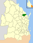
The Shire of Isis was a local government area located in the Wide Bay–Burnett region of Queensland, Australia, to the south of Bundaberg. The Shire, administered from the town of Childers covered an area of 1,702.2 square kilometres (657.2 sq mi), and existed as a local government entity from 1887 until 2008, when it was amalgamated with the City of Bundaberg and the Shires of Burnett and Kolan to form the Bundaberg Region.

Wallaville Town in Queensland, Australia

Wallaville is a rural town and locality in the Bundaberg Region, Queensland, Australia. It is 372 kilometres (231 mi) north of the state capital, Brisbane and 43 kilometres (27 mi) south west of the regional centre of Bundaberg. In the 2016 census, Wallaville had a population of 410 people.

Buxton, Queensland Town in Queensland, Australia

Buxton is a rural locality in the Bundaberg Region, Queensland, Australia. In the 2016 census, Buxton had a population of 430 people.

Bullyard Town in Queensland, Australia

Bullyard is a small rural town and locality in Bundaberg Region, Queensland, Australia. In 2016 census Bullyard had a population of 189 people.

Cordalba Town in Queensland, Australia

Cordalba is a rural town and locality in the Bundaberg Region, Queensland, Australia. In the 2016 census, Cordalba had a population of 445 people.

Apple Tree Creek, Queensland Town in Queensland, Australia

Apple Tree Creek is a rural town and locality in the Bundaberg Region, Queensland, Australia. It was formerly known as Bodalla, the Dundaburra people of the Northern Kabi group name from the Gregory River Plum which to first Europeans looked like an apple. Prior to settlement of the Isis District which includes Apple tree Creek - the area was called Buth'arth translating to scrub. The town was renamed in 1962. In the 2016 census, Apple Tree Creek had a population of 639 people.

South Kolan Town in Queensland, Australia

South Kolan is a rural locality in the Bundaberg Region, Queensland, Australia. In the 2016 census, South Kolan had a population of 1,061 people.

Oakwood, Queensland Town in Queensland, Australia

Oakwood is a rural locality in the Bundaberg Region of the greater Wide Bay region of Queensland, Australia. In the 2016 census, Oakwood had a population of 331 people.

Coral Cove, Queensland Suburb of Bundaberg, Queensland, Australia

Coral Cove is a coastal locality in the Bundaberg Region, Queensland, Australia. In the 2016 census, Coral Cove had a population of 1,268 people. It has been used as a diving point by tourists and contains the Coral Cove Golf course.

Bauple, Queensland Town in Queensland, Australia

Bauple is a rural town and locality in the Fraser Coast Region, Queensland, Australia. In the 2016 census, Bauple had a population of 644 people.

Horton, Queensland Town in Queensland, Australia

Horton is a rural town and a locality in the Bundaberg Region, Queensland, Australia. In the 2016 census, Horton had a population of 158 people.

Booyal, Queensland Town in Queensland, Australia

Booyal is a town and a locality in the Bundaberg Region, Queensland, Australia. In the 2016 census, Booyal had a population of 275 people.

North Isis Suburb of Bundaberg Region, Queensland, Australia

North Isis is a rural locality in the Bundaberg Region, Queensland, Australia. In the 2016 census North Isis had a population of 533 people.

Elliott, Queensland Suburb of Bundaberg Region, Queensland, Australia

Elliott is a rural locality in the Bundaberg Region, Queensland, Australia. In the 2016 census, Elliott had a population of 138 people.

Bucca, Queensland Suburb of Bundaberg Region, Queensland, Australia

Bucca is a rural locality in the Bundaberg Region, Queensland, Australia. In the 2016 census, Bucca had a population of 1,027 people. The neighbourhood of Kolan is within the locality.

Pine Creek, Queensland Suburb of Bundaberg Region, Queensland, Australia

Pine Creek is a rural locality in the Bundaberg Region, Queensland, Australia. In the 2016 census Pine Creek had a population of 254 people.

Calavos, Queensland Suburb of Bundaberg Region, Queensland, Australia

Calavos is a rural locality in the Bundaberg Region, Queensland, Australia. In the 2016 census, Calavos had a population of 331 people.

Isis Central, Queensland Suburb of Bundaberg Region, Queensland, Australia

Isis Central is a locality in the Bundaberg Region, Queensland, Australia. In the 2016 census, Isis Central had a population of 216 people.

Redridge, Queensland Suburb of Bundaberg Region, Queensland, Australia

Redridge is a locality in the Bundaberg Region, Queensland, Australia. In the 2016 census, Redridge had a population of 628 people.

References

  1. 1 2 3 Australian Bureau of Statistics (27 June 2017). "Doolbi (SSC)". 2016 Census QuickStats. Retrieved 20 October 2018. OOjs UI icon edit-ltr-progressive.svg
  2. "Doolbi – locality in Bundaberg Region (entry 50193)". Queensland Place Names. Queensland Government . Retrieved 18 September 2020.
  3. 1 2 "Queensland Globe". State of Queensland . Retrieved 20 October 2020.
  4. "Doolbi Sugar Mill Remains" (PDF). Bundaberg Regional Council . Retrieved 16 November 2015.
  5. Queensland Family History Society (2010), Queensland schools past and present (Version 1.01 ed.), Queensland Family History Society, ISBN   978-1-921171-26-0

Commons-logo.svg Media related to Doolbi, Queensland at Wikimedia Commons