Fairymead, Queensland

Last updated

Fairymead
Queensland
Queensland State Archives 5142 Sugar Cane train Fairy Mead Bundaberg c 1896.png
Sugarcane train, Fairy Mead, circa 1896
Australia Queensland location map.svg
Red pog.svg
Fairymead
Coordinates 24°46′17″S152°21′12″E / 24.7713°S 152.3533°E / -24.7713; 152.3533 (Fairymead (centre of locality))
Population28 (2021 census) [1]
 • Density0.444/km2 (1.151/sq mi)
Postcode(s) 4670
Area63.0 km2 (24.3 sq mi)
Time zone AEST (UTC+10:00)
Location
LGA(s) Bundaberg Region
State electorate(s) Burnett
Federal division(s) Flynn
Suburbs around Fairymead:
Moore Park Beach Coral Sea Coral Sea
Welcome Creek Fairymead Burnett Heads
Gooburrum Rubyanna Rubyanna

Fairymead is a coastal locality in the Bundaberg Region, Queensland, Australia. [2] In the 2021 census, Fairymead had a population of 28 people. [1]

Contents

Geography

Fairymead is bounded to the north and north-east by the Coral Sea and to east and south-east by the Burnett River. [3]

Barubbra Island is an island at the mouth of the Burnett River ( 24°44′56″S152°23′10″E / 24.7488°S 152.3861°E / -24.7488; 152.3861 (Barubbra Island) ). [4] It is a wetland area protected within the Barubbra Island Conservation Park. [4] [3]

The predominant land use is growing sugarcane. [3] There is a cane tramway network through the locality to transport the harvested sugarcane to local sugar mills. [3]

History

Fairymead was originally established as the Fairymead Sugar Plantation with its associated Fairymead Sugar Mill ( 24°47′23″S152°21′24″E / 24.7898°S 152.3568°E / -24.7898; 152.3568 (Fairymead Sugar Mill (former)) ). [5] The heritage-listed house built by the plantation owners, Fairymead House, has been relocated to the Bundaberg Botanic Gardens. [6]

Fairymead Provisional School opened on 20 July 1893. On 1 January 1909 it became Fairymead State School. It closed in 1983. [7] It was located at the eastern end of Colvins Road (approx 24°48′34″S152°20′54″E / 24.8094°S 152.3484°E / -24.8094; 152.3484 (Fairymead State School (former)) ). [8] [9] [3]

Demographics

In the 2016 census, Fairymead had a population of 33 people. [10]

In the 2021 census, Fairymead had a population of 28 people. [1]

Education

There are no schools in Fairymead. The nearest government primary schools are Moore Park Beach State School in neighbouring Moore Park Beach to the north-west, Gooburrum State School in neighbouring Gooburrum to the south-west, and Bundaberg North State School in Bundaberg North to the south. The nearest government secondary school is Bundaberg North State High School in Bundaberg North. [3]

See also

Related Research Articles

<span class="mw-page-title-main">Burnett Heads, Queensland</span> Town in Queensland, Australia

Burnett Heads is a coastal town and locality in the Bundaberg Region, Queensland, Australia. In the 2016 census, the locality of Burnett Heads had a population of 2,656 people.

<span class="mw-page-title-main">Wallaville</span> Town in Queensland, Australia

Wallaville is a rural town and locality in the Bundaberg Region, Queensland, Australia. It is 372 kilometres (231 mi) north of the state capital, Brisbane and 43 kilometres (27 mi) south west of the regional centre of Bundaberg. In the 2016 census, Wallaville had a population of 410 people.

<span class="mw-page-title-main">Moore Park Beach, Queensland</span> Town in Queensland, Australia

Moore Park Beach is a coastal rural locality in the Bundaberg Region, Queensland, Australia. The coastal town of Moore Park is within the locality.

<span class="mw-page-title-main">Shire of Gooburrum</span> Local government area in Queensland, Australia

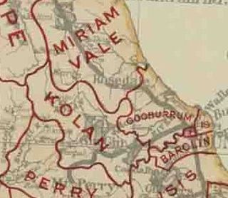
The Shire of Gooburrum was a local government area to the north and west of the regional city of Bundaberg, Australia. This area, administered from Bundaberg itself, covered an area of 1,312.6 square kilometres (506.8 sq mi), and existed as a local government entity from 1886 until 1994, when it amalgamated with Woongarra to form the Shire of Burnett.

<span class="mw-page-title-main">South Kolan</span> Town in Queensland, Australia

South Kolan is a rural locality in the Bundaberg Region, Queensland, Australia. In the 2021 census, South Kolan had a population of 1,258 people.

<span class="mw-page-title-main">Bundaberg North, Queensland</span> Suburb of Bundaberg, Queensland, Australia

Bundaberg North is a suburb of Bundaberg in the Bundaberg Region, Queensland, Australia. In the 2016 census, Bundaberg North had a population of 5,451 people. It occupies the developed area north of the Burnett River, opposite the Bundaberg CBD.

<span class="mw-page-title-main">Fairymead House</span> Historic site in Queensland, Australia

Fairymead House is a heritage-listed homestead at Thornhill Street, Bundaberg North, Bundaberg Region, Queensland, Australia. It was designed by John Shedden Adam and built in 1890. It was added to the Queensland Heritage Register on 22 February 2002.

<span class="mw-page-title-main">Qunaba, Queensland</span> Suburb of Bundaberg Region, Queensland, Australia

Qunaba is a rural locality in the Bundaberg Region, Queensland, Australia. In the 2016 census Qunaba had a population of 793 people.

North Isis is a rural locality in the Bundaberg Region, Queensland, Australia. In the 2016 census North Isis had a population of 533 people.

Gooburrum is a rural locality in the Bundaberg Region, Queensland, Australia. In the 2021 census, Gooburrum had a population of 1,518 people. The neighbourhood of Tantitha is within the locality.

<span class="mw-page-title-main">Woongarra, Queensland</span> Suburb of Bundaberg, Queensland, Australia

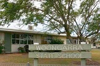
Woongarra is a rural locality in the Bundaberg Region, Queensland, Australia. In the 2021 census, Woongarra had a population of 585 people.

Elliott is a rural locality in the Bundaberg Region, Queensland, Australia. In the 2021 census, Elliott had a population of 156 people.

<span class="mw-page-title-main">Bucca, Queensland</span> Suburb of Bundaberg Region, Queensland, Australia

Bucca is a rural locality in the Bundaberg Region, Queensland, Australia. In the 2016 census, Bucca had a population of 1,027 people. The neighbourhood of Kolan is within the locality.

<span class="mw-page-title-main">Rita Island, Queensland</span> Suburb of Shire of Burdekin, Queensland, Australia

Rita Island is a coastal and rural locality in the Shire of Burdekin, Queensland, Australia. In the 2016 census, Rita Island had a population of 152 people.

Pine Creek is a rural locality in the Bundaberg Region, Queensland, Australia. In the 2016 census Pine Creek had a population of 254 people.

<span class="mw-page-title-main">Fairymead Sugar Plantation</span>

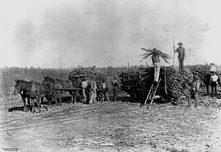
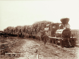
Fairymead Sugar Plantation was a sugar plantation in Fairymead, Bundaberg Region, Queensland, Australia. It was established by Ernest Young together with his father Henry and brothers Arthur, and Horace. It was one of Bundaberg's earliest independent sugar plantations and had one of its earliest sugar mills.

Duingal is a locality in the Bundaberg Region, Queensland, Australia. In the 2021 census, Duingal had a population of 70 people.

<span class="mw-page-title-main">Isis Central, Queensland</span> Suburb of Bundaberg Region, Queensland, Australia

Isis Central is a rural locality in the Bundaberg Region, Queensland, Australia. In the 2021 census, Isis Central had a population of 205 people.

Redridge is a locality in the Bundaberg Region, Queensland, Australia. In the 2016 census, Redridge had a population of 628 people.

<span class="mw-page-title-main">South Isis</span> Suburb of Bundaberg Region, Queensland, Australia

South Isis is a rural locality in the Bundaberg Region, Queensland, Australia. In the 2021 census, South Isis had a population of 381 people.

References

  1. 1 2 3 Australian Bureau of Statistics (28 June 2022). "Fairymead (SAL)". 2021 Census QuickStats. Retrieved 28 February 2023. OOjs UI icon edit-ltr-progressive.svg
  2. "Fairymead – locality in Bundaberg Region (entry 44717)". Queensland Place Names. Queensland Government . Retrieved 28 December 2017.
  3. 1 2 3 4 5 6 "Queensland Globe". State of Queensland . Retrieved 8 September 2023.
  4. 1 2 "Barubbra Island – island in Bundaberg Regional (entry 1783)". Queensland Place Names. Queensland Government . Retrieved 29 August 2023.
  5. "9348-24 Bundaberg" (Map). Queensland Government. 2009. Archived from the original on 7 September 2023. Retrieved 8 September 2023.
  6. "Fairymead House (entry 601009)". Queensland Heritage Register . Queensland Heritage Council. Retrieved 1 August 2014.
  7. Queensland Family History Society (2010), Queensland schools past and present (Version 1.01 ed.), Queensland Family History Society, ISBN   978-1-921171-26-0
  8. "County of Cook" (Map). Queensland Government. 1920. Archived from the original on 21 February 2020. Retrieved 14 July 2021.
  9. "Bundaberg" (Map). Queensland Government. 1943. Archived from the original on 30 September 2020. Retrieved 14 July 2021.
  10. Australian Bureau of Statistics (27 June 2017). "Fairymead (SSC)". 2016 Census QuickStats. Retrieved 20 October 2018. OOjs UI icon edit-ltr-progressive.svg

Commons-logo.svg Media related to Fairymead, Queensland at Wikimedia Commons