Doran, Minnesota

Last updated

Doran
Wilkin County Minnesota Incorporated and Unincorporated areas Doran Highlighted.svg
Location of Doran, Minnesota
Coordinates: 46°11′07″N96°29′08″W / 46.18528°N 96.48556°W / 46.18528; -96.48556
CountryUnited States
State Minnesota
County Wilkin
Area
[1]
  Total0.21 sq mi (0.54 km2)
  Land0.21 sq mi (0.54 km2)
  Water0.00 sq mi (0.00 km2)
Elevation
[2]
974 ft (297 m)
Population
 (2020) [3]
  Total36
  Estimate 
(2021) [4]
34
  Density173.91/sq mi (67.06/km2)
Time zone UTC-6 (CST)
  Summer (DST) UTC-5 (CDT)
ZIP code
56522
Area code 218
FIPS code 27-16156
GNIS feature ID2394549 [2]

Doran is a city in Wilkin County, Minnesota, United States. The population was 36 at the 2020 census. [3] It is part of the Wahpeton, ND-MN Micropolitan Statistical Area.

Contents

History

A post office called Doran was established in 1892, and remained in operation until 1989. [5] The city was named for Michael Doran, a state legislator. [6]

Notable person

Paul D. Aasness (1939-2017), farmer, businessman and politician, grew up on the family farm near Doran. [7]

Geography

According to the United States Census Bureau, the city has a total area of 0.21 square miles (0.54 km2), all land. [8]

Doran is located at the junction of U.S. Route 75 and Minnesota State Highway 9.

Demographics

Historical population
CensusPop.Note
1910 93
1920 985.4%
1930 13739.8%
1940 128−6.6%
1950 126−1.6%
1960 1367.9%
1970 101−25.7%
1980 77−23.8%
1990 781.3%
2000 59−24.4%
2010 55−6.8%
2020 36−34.5%
2021 (est.)34 [4] −5.6%
U.S. Decennial Census [9]
2020 Census [3]

2010 census

As of the census of 2010, there were 55 people, 21 households and 14 families living in the city. The population density was 261.9 inhabitants per square mile (101.1/km2). There were 27 housing units at an average density of 128.6 per square mile (49.7/km2). The racial makeup was 100.0% White.

There were 21 households, of which 42.9% had children under the age of 18 living with them, 42.9% were married couples living together, 14.3% had a female householder with no husband present, 9.5% had a male householder with no wife present, and 33.3% were non-families. 23.8% of all households were made up of individuals, and 9.5% had someone living alone who was 65 years of age or older. The average household size was 2.62 and the average family size was 3.21.

The median age was 34.5 years. 29.1% of residents were under the age of 18; 5.5% were between the ages of 18 and 24; 23.6% were from 25 to 44; 36.4% were from 45 to 64; and 5.5% were 65 years of age or older. The gender makeup of the city was 49.1% male and 50.9% female.

2000 census

As of the census of 2000, there were 59 people, 24 households and 15 families living in the city. The population density was 284.1 inhabitants per square mile (109.7/km2). There were 31 housing units at an average density of 149.3 per square mile (57.6/km2). The racial makeup was 91.53% White, 1.69% African American, 1.69% Native American, and 5.08% from two or more races.

There were 24 households, of which 33.3% had children under the age of 18 living with them, 54.2% were married couples living together, 4.2% had a female householder with no husband present, and 37.5% were non-families. 29.2% of all households were made up of individuals, and 12.5% had someone living alone who was 65 years of age or older. The average household size was 2.46 and the average family size was 3.07.

18.6% of the population were under the age of 18, 11.9% from 18 to 24, 33.9% from 25 to 44, 22.0% from 45 to 64, and 13.6% who were 65 years of age or older. The median age was 40 years. For every 100 females, there were 96.7 males. For every 100 females age 18 and over, there were 108.7 males.

The median household income was $26,250 and the median family income was $56,250. Males had a median income of $30,833 and females $23,750. The per capita income was $15,959. There were 12.5% of families and 15.5% of the population living below the poverty line, including no under eighteens and none of those over 64.

Related Research Articles

<span class="mw-page-title-main">Chickamaw Beach, Minnesota</span> City in Minnesota, United States

Chickamaw Beach is a city in Cass County, Minnesota, United States. The population was 114 at the 2010 census. It is part of the Brainerd Micropolitan Statistical Area.

<span class="mw-page-title-main">Comstock, Minnesota</span> City in Minnesota, United States

</ref>

<span class="mw-page-title-main">Garfield, Minnesota</span> City in Minnesota, United States

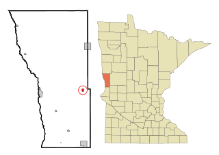
Garfield is a city in Douglas County, Minnesota, United States. The population was 349 at the 2020 census.

<span class="mw-page-title-main">Warba, Minnesota</span> City in Minnesota, United States

Warba is a city in Itasca County, Minnesota, United States. The population was 181 at the 2010 census.

<span class="mw-page-title-main">Buckman, Minnesota</span> City in Minnesota, United States

Buckman is a city in Morrison County, Minnesota, United States. The population was 307 at the 2020 Census.

<span class="mw-page-title-main">Elmdale, Minnesota</span> City in Minnesota, United States

Elmdale is a city in Morrison County, Minnesota, United States. The population was 114 at the 2020 census.

<span class="mw-page-title-main">Deer Creek, Minnesota</span> City in Minnesota, United States

Deer Creek is a city in Otter Tail County, Minnesota, United States. The population was 330 at the 2020 census.

<span class="mw-page-title-main">Henning, Minnesota</span> City in Minnesota, United States

Henning is a city in Otter Tail County, Minnesota, United States. The population was 854 at the 2020 census.

<span class="mw-page-title-main">Ottertail, Minnesota</span> City in Minnesota, United States

Ottertail is a city in Otter Tail County, Minnesota, United States. The population was 629 at the 2020 census.

<span class="mw-page-title-main">Henriette, Minnesota</span> City in Minnesota, United States

Henriette, is a city in Pine County, Minnesota, United States. The population was 71 at the 2010 census.

<span class="mw-page-title-main">Nielsville, Minnesota</span> City in Minnesota, United States

Nielsville is a city in Polk County, Minnesota, United States. It is part of the Grand Forks, ND-MN Metropolitan Statistical Area. The population was 78 at the 2020 census.

<span class="mw-page-title-main">Winton, Minnesota</span> City in Minnesota, United States

Winton is a city in Saint Louis County, Minnesota, United States. The population was 172 at the 2010 census. The city is home to a small hydroelectric dam on the edge of Garden Lake, one of 11 stations owned by Minnesota Power.

<span class="mw-page-title-main">Kimball, Minnesota</span> City in Minnesota, United States

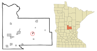
Kimball is a city in Stearns County, Minnesota, United States. The population was 799 at the 2020 census. It is part of the St. Cloud Metropolitan Statistical Area.

<span class="mw-page-title-main">Foxhome, Minnesota</span> City in Minnesota, United States

Foxhome is a city in Wilkin County, Minnesota, United States. The population was 126 at the 2020 census. It is part of the Wahpeton, ND—MN Micropolitan Statistical Area.

<span class="mw-page-title-main">Minnesota City, Minnesota</span> City in Minnesota, United States

Minnesota City is a city in Winona County, Minnesota, United States. The population was 202 at the 2020 census.

<span class="mw-page-title-main">Fifty Lakes, Minnesota</span> City in Minnesota, United States

Fifty Lakes is a city in Crow Wing County, Minnesota, United States. The population was 387 at the 2010 census. It is part of the Brainerd Micropolitan Statistical Area.

<span class="mw-page-title-main">Genola, Minnesota</span> City in Minnesota, United States

Genola is a city in Morrison County, Minnesota, United States. The population was 70 at the 2020 census.

<span class="mw-page-title-main">St. Anthony, Stearns County, Minnesota</span> City in Minnesota, United States

St. Anthony or Saint Anthony is a city in Stearns County, Minnesota, United States. The population was 86 at the 2010 census. It is part of the St. Cloud Metropolitan Statistical Area. Main routes include Minnesota State Highway 238, Stearns County Road 153, and Trobec Street.

<span class="mw-page-title-main">Minnesota Lake, Minnesota</span> City in Minnesota, United States

Minnesota Lake is a city in Blue Earth and Faribault counties in the State of Minnesota. The population was 661 at the 2020 census. The bulk of the city is in Faribault County; a small part extends into Blue Earth County.

<span class="mw-page-title-main">Minneiska, Minnesota</span> City in Minnesota, United States

Minneiska is a city in Wabasha and Winona counties in the U.S. state of Minnesota. The population was 111 at the 2010 census.

References

  1. "2020 U.S. Gazetteer Files". United States Census Bureau. Retrieved July 24, 2022.
  2. 1 2 U.S. Geological Survey Geographic Names Information System: Doran, Minnesota
  3. 1 2 3 "Explore Census Data". United States Census Bureau . Retrieved May 1, 2022.
  4. 1 2 "City and Town Population Totals: 2020-2021". United States Census Bureau. June 19, 2022. Retrieved June 19, 2022.
  5. "Wilkin County". Jim Forte Postal History. Archived from the original on March 4, 2016. Retrieved August 14, 2015.
  6. Upham, Warren (1920). Minnesota Geographic Names: Their Origin and Historic Significance. Minnesota Historical Society. p.  578.
  7. Tom Hintgen, "Corn harvest foe Aasness family", The Fergus Falls Daily Journal, October 9, 2008
  8. "US Gazetteer files 2010". United States Census Bureau. Archived from the original on July 2, 2012. Retrieved November 13, 2012.
  9. United States Census Bureau. "Census of Population and Housing" . Retrieved September 10, 2013.