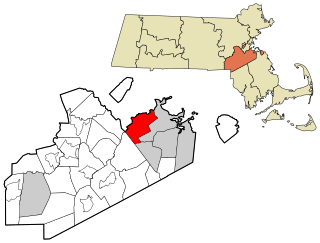
Milton is a town in Norfolk County, Massachusetts, United States and an affluent suburb of Boston. The population was 28,630 at the 2020 census. Milton is the birthplace of former U.S. President George H. W. Bush, and architect Buckminster Fuller. Milton was ranked by Money as the 2nd, 7th, and 8th best town to live in the United States in 2011, 2009 and 2019, and 2021, respectively.

Dorchester is a Boston neighborhood comprising more than 6 square miles (16 km2) in the City of Boston, Massachusetts, United States. Originally, Dorchester was a separate town, founded by Puritans who emigrated in 1630 from Dorchester, Dorset, England, to the Massachusetts Bay Colony. This dissolved municipality, Boston's largest neighborhood by far, is often divided by city planners in order to create two planning areas roughly equivalent in size and population to other Boston neighborhoods.
The Neponset River is a river in eastern Massachusetts in the United States. Its headwaters are at the Neponset Reservoir in Foxborough, near Gillette Stadium. From there, the Neponset meanders generally northeast for about 29 miles (47 km) to its mouth at Dorchester Bay between Quincy and the Dorchester section of Boston, near the painted gas tank.

This is a list of properties and districts in Massachusetts listed on the National Register of Historic Places. There are over 4,300 listings in the state, representing about 5% of all NRHP listings nationwide and the second-most of any U.S. state, behind only New York. Listings appear in all 14 Massachusetts counties.

Henry Lillie Pierce was a United States representative from Massachusetts. He was born in Stoughton. He attended the State normal school at Bridgewater, and was engaged in manufacturing. He served as Mayor of Boston and as a Republican in the Forty-third and Forty-fourth Congresses of the United States. He declined to be a candidate for renomination, was again Mayor of Boston in 1878, and died in that city on December 17, 1896. His interment was in Dorchester South Burying Ground.

North Uxbridge is a village and a post office in the town (township) of Uxbridge in Worcester County, Massachusetts, United States. The postal zip code is 01538. It is classified as a community or populated place located at latitude 42.088 and longitude -71.641 and the elevation is 266 feet (81 m). North Uxbridge appears on the Uxbridge U.S. Geological Survey Map. Worcester County is in the Eastern time zone and observes DST. North Uxbridge is located about 36 miles WSW of Boston, and 15 miles SE of Worcester. The town meeting in 1885 set aside North Uxbridge as a "special district", since its population had exceeded 1000 people. North Uxbridge appeared to be a separate Census tract in the 1960 census with a population of 1882. In 2013, an Uxbridge DIY show, The Garage, with Steve Butler, went worldwide from Steve's garage in North Uxbridge.

Baker's Chocolate is a brand name for the line of baking chocolates owned by Kraft Heinz. Products include a variety of bulk chocolates, including white and unsweetened, and sweetened coconut flakes. It is one of the largest national brands of chocolate in the United States. The company was originally named Walter Baker & Company.

Milton station is a light rail station in Milton, Massachusetts. Located in the Dorchester-Milton Lower Mills Industrial District, it serves the MBTA's Ashmont–Mattapan High-Speed Line. This station is accessible via wooden ramps on both platforms.
The Neponset Valley Parkway is a historic parkway in southern Boston and Milton, Massachusetts, United States. It is a connecting parkway in the Greater Boston area's network, providing a connection between the Blue Hills Reservation, Neponset River Reservation, and the Stony Brook Reservation. The parkway was constructed between 1898 and 1929 with design assistance from Charles Eliot and the Olmsted Brothers. It was listed on the National Register of Historic Places in 2005.

The Truman Parkway is a historic parkway in Milton and southern Boston, Massachusetts. It runs along the southern boundary of a portion of the Neponset River Reservation and serves as a connection between the Neponset Valley Parkway and the Blue Hills Parkway. The parkway was built in 1931 and added to the National Register of Historic Places in 2005.

Butler station is a light rail station in Boston, Massachusetts. It serves the MBTA Ashmont–Mattapan High-Speed Line. It is located at Butler Street in the Lower Mills section of the Dorchester neighborhood. It serves a small residential area sandwiched between the Neponset River, Cedar Grove Cemetery, and Dorchester Park. Butler station has no MBTA bus connections. It is accessible via a wooden mini-high ramp on the station's single island platform.

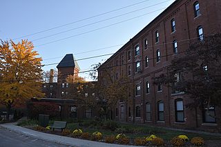
The Ipswich Mills Historic District encompasses a major textile mill complex and associated worker housing along the Ipswich River near the center of Ipswich, Massachusetts. The district includes the factories of the Ipswich Mill Company, and several blocks of modest worker cottages mostly on side streets off Estes and Kimball Streets. The site had been used as for mills since the 17th century, and was purchased by the Ipswich Mill Company in 1868. Mill worker housing was built surrounding the complex through the early 20th century, when River Court, Peatfield Street, and 1st through 6th Streets were laid out. The district was listed on the National Register of Historic Places in 1996.
The Wamesit Canal-Whipple Mill Industrial Complex is a historic mill and canal at 576 Lawrence Street in Lowell, Massachusetts. This industrial area of Lowell, located on the Concord River, underwent a major expansion from a more modest millworks in the mid-19th century by Oliver Whipple, a manufacturer of gunpowder.

Blue Hills Parkway is a historic parkway that runs in a straight line from a crossing of the Neponset River, at the south border of Boston to the north edge of the Blue Hills Reservation in Milton, Massachusetts. It was built in 1893 to a design by the noted landscape architect, Charles Eliot, who is perhaps best known for the esplanades along the Charles River. The parkway is a connecting road between the Blue Hills Reservation and the Neponset River Reservation, and was listed on the National Register of Historic Places in 2003.

The Milton Centre Historic District encompasses the traditional civic heart of Milton, Massachusetts. The district is located on Canton Avenue between Readsdale Road and Thacher and Highland Streets, and includes municipal buildings, churches, and residences, most built in the 18th or 19th century. The district was listed on the National Register of Historic Places in 1988.
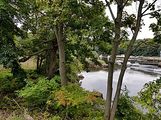
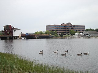
Neponset River Reservation is a Massachusetts state reservation along the Neponset River in the towns of Milton and Dorchester, near where the river flows through an estuary into the Boston Harbor. It is adjacent to the Dorchester-Milton Lower Mills Industrial District along the River. This was some of the last land retained by Cutshamekin (Massachusett) before he deeded much of the land comprising Dorchester and Milton to English colonists in the 17th century.
Israel Stoughton was an early English colonist in Massachusetts and a colonial commander in the Pequot War. Returning to England, he served as Parliamentarian officer in the First English Civil War.

Bradlee, Winslow & Wetherell (1872-1888) was an architecture firm in Boston, Massachusetts. Its principals were Nathaniel Jeremiah Bradlee (1829-1888), Walter Thacher Winslow (1843-1909) and George Homans Wetherell (1854-1930). Most of the firm's work was local to Boston and New England, with a few commissions as far afield as Seattle and Kansas City.
John Whipple was an early settler of Dorchester in the Massachusetts Bay Colony, who later settled in Providence in the Colony of Rhode Island and Providence Plantations, where the family became well established.

The Lower Neponset River Trail is a 2.4-mile-long (3.9 km) rail trail running along the Neponset River in the Dorchester section of Boston, Massachusetts. It roughly follows the path of the eastern part of the Dorchester and Milton Branch Railroad from the Port Norfolk neighborhood in Dorchester to the Central Avenue T Station in Milton, passing through Pope John Paul II Park, the Neponset Marshes, and the Lower Mills area.


