
Green-Wood Cemetery is a 478-acre (193 ha) cemetery in the western portion of Brooklyn, New York City. The cemetery is located between South Slope/Greenwood Heights, Park Slope, Windsor Terrace, Borough Park, Kensington, and Sunset Park, and lies several blocks southwest of Prospect Park. Its boundaries include, among other streets, 20th Street to the northeast, Fifth Avenue to the northwest, 36th and 37th Streets to the southwest, Fort Hamilton Parkway to the south, and McDonald Avenue to the east.

The Boston Common is a public park in downtown Boston, Massachusetts. It is the oldest city park in the United States. Boston Common consists of 50 acres (20 ha) of land bounded by Tremont Street, Park Street, Beacon Street, Charles Street, and Boylston Street.

Dorchester is a Boston neighborhood comprising more than 6 square miles (16 km2) in the City of Boston, Massachusetts, United States. Originally, Dorchester was a separate town, founded by Puritans who emigrated in 1630 from Dorchester, Dorset, England, to the Massachusetts Bay Colony. This dissolved municipality, Boston's largest neighborhood by far, is often divided by city planners in order to create two planning areas roughly equivalent in size and population to other Boston neighborhoods.

William Stoughton was a New England Puritan magistrate and administrator in the Province of Massachusetts Bay. He was in charge of what have come to be known as the Salem Witch Trials, first as the Chief Justice of the Special Court of Oyer and Terminer in 1692, and then as the Chief Justice of the Superior Court of Judicature in 1693. In these trials he controversially accepted spectral evidence. Unlike some of the other magistrates, he never admitted to the possibility that his acceptance of such evidence was in error.

The James Blake House is the oldest surviving house in Boston, Massachusetts, United States. The house was built in 1661 and the date was confirmed by dendrochronology in 2007. It is located at 735 Columbia Road, in Edward Everett Square, and just a block from Massachusetts Avenue. The Dorchester Historical Society now owns the building and tours are given on the third Sunday of the month.

Richmond National Cemetery is a United States National Cemetery three miles (4.8 km) east of Richmond in Henrico County, Virginia. Administered by the United States Department of Veterans Affairs, it encompasses 9.7 acres (3.9 ha), and as of 2021 had more than 11,000 interments. It is closed to new interments. Richmond National Cemetery was listed on the National Register of Historic Places in 1995.

The West Parish Burying Ground, also known as the River Street Burying Ground or River Street Cemetery, is a cemetery located at River and Cherry streets in West Newton, Massachusetts, and is listed on the National Register of Historic Places. Established in 1777, the cemetery is owned and maintained by the City of Newton; the Second Church in Newton, its original owner, was known as the West Parish.

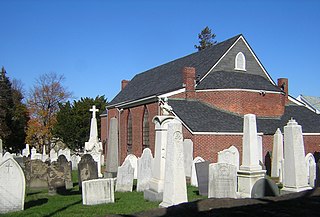
Copp's Hill Burying Ground is a historic cemetery in the North End of Boston, Massachusetts. Established in 1659, it was originally named "North Burying Ground", and was the city's second cemetery.

Cole's Hill is a National Historic Landmark containing the first cemetery used by the Mayflower Pilgrims in Plymouth, Massachusetts in 1620. The hill is located on Carver Street near the foot of Leyden Street and across the street from Plymouth Rock. Owned since 1820 by the preservationist Pilgrim Society, it is now a public park.

The Bennington Street Burying Ground is a historic cemetery on Bennington Street, between Swift St. and Harmony St., in East Boston, Massachusetts.

Eliot Burying Ground is a historic seventeenth-century graveyard at Eustis and Washington Streets in the Roxbury neighborhood of Boston, Massachusetts. It occupies a roughly triangular lot of 0.8 acres (0.32 ha).
Saint Augustine Chapel and Cemetery is a historic church on Dorchester Street between West Sixth and Tudor Streets in the South Boston neighborhood of Boston, Massachusetts. Built in 1818–19, it is the oldest Roman Catholic church building in Massachusetts; the cemetery, established 1818 is also the state's oldest Catholic cemetery. The Gothic Revival chapel was originally built as a crypt for the remains of Father François Matignon, the first Catholic priest to come to Boston from France. Father Dennis J. O'Donovan is also buried there.
The Rumney Marsh Burying Ground is a historic cemetery on Butler Street between Elm and Bixby Streets in Revere, Massachusetts. It was added to the National Register of Historic Places in 2004. It was the first burying ground of an area that now encompasses Revere as well as neighboring Chelsea and Winthrop.

The Upham's Corner Market is an historic commercial building at 600 Columbia Road in the Dorchester neighborhood of Boston, Massachusetts. It is actually three separate buildings built c. 1919, 1923, and 1926. They were built by brothers John and Paul Cifrino, who were Italian immigrants. They established a small neighborhood grocery store in 1915, before building this series of buildings to house what became an early supermarket. After the third section was built, the store had 50,000 square feet (4,600 m2) of space, and was the largest store of its kind in the city, serving a nearby population of more than 250,000. The buildings have been converted to mixed commercial and residential use.

The Pan Burying Ground is an historic cemetery on 477 Main Street in Bolton, Massachusetts. Established in 1822, the cemetery was the second in the town. It was named for the area known locally as "The Pan", which had by then become the second-largest village center in the town. The original 1.18-acre (0.48 ha) plot has 400 marked graves, and is presumed to contain further unmarked graves, based on a pattern of marker layout at the rear of this portion of the cemetery. The cemetery was enlarged to 3.3 acres (1.3 ha) in the 1960s. It is distinctive in Bolton for its seven-chambered group tomb, built in 1839 at the southeast corner of the property.

Uphams Corner, or Upham's Corner, is a commercial center in Dorchester, the largest neighborhood of Boston, Massachusetts. The intersection of Dudley Street/Stoughton Street and Columbia Road is the heart of Uphams Corner, and one of Dorchester's main business districts.

The Old Burying Ground is a historic cemetery on Pleasant and William Streets in Stoneham, Massachusetts. Established in 1726, it is the only surviving element of Stoneham's original town center, which also included a meeting house and school. It contains about 450 stones and fragments, with grave markers dating from 1728 to 1924. The stones were carved with motifs that were fairly typical of the period including urns, willows, cherubs, and winged death heads.

Fairview Cemetery is a historic cemetery in the Hyde Park neighborhood of Boston, Massachusetts. A small section of the cemetery is located in neighboring Dedham. The cemetery was established by the town of Hyde Park in 1892, and became the responsibility of the city of Boston when it annexed that town in 1912. The cemetery was added to the National Register of Historic Places on September 16, 2009. It is the newest of Boston's cemeteries, and has more than 40,000 burials. It is the location where the City of Boston “bury indigent and unclaimed people”.

The Dorchester South Burying Ground is a historic graveyard on Dorchester Avenue in the Dorchester neighborhood of Boston, Massachusetts. Established in 1814, it is the second oldest cemetery in Dorchester, after the North Burying Ground. It is a roughly 2-acre (0.81 ha) parcel on the west side of Dorchester Avenue, north of Dorchester Lower Mills. A paved roadway provides circulation around the perimeter of the property. There is some evidence that the cemetery was formally terraced, due to the sloping terrain, but there is no evidence of curbing that might have been used for this purpose. One of the cemetery's most prominent features is a line of granite tombs along the southern boundary.
The Dudley Terrace–Dudley Street Historic District is a historic district encompassing a cluster of four multifamily brick buildings in the Dorchester neighborhood of Boston, Massachusetts. Centered on the junction of Dudley Street and Virginia Avenue, the area was developed in the mid-1890s, and includes good examples of Queen Anne and Renaissance Revival architecture. The district was listed on the National Register of Historic Places in 2022.


