
This is a list of properties and historic districts in Oregon that are listed on the National Register of Historic Places. There are listings in all of Oregon's 36 counties.

Vida is an unincorporated community in Lane County, Oregon, United States. It is located on Oregon Route 126 and the McKenzie River.

The Office Bridge is a covered bridge in Westfir, Lane County, Oregon, U.S. crossing the North Fork Middle Fork Willamette River at the south end of the Aufderheide National Scenic Byway and edge of the Willamette National Forest. It is Oregon's longest covered bridge at 180 ft, and is one of only two in the state using triple Howe truss construction. It is the only covered bridge west of the Mississippi River which has a separate pedestrian walkway.
The Row River is a river, approximately 20 miles (32 km) long, in Lane County, Oregon, United States. It rises in the Cascade Range and flows into the Coast Fork Willamette River near Cottage Grove. The stream was originally known as the "East Fork Coast Fork", but was later renamed after a dispute (row) between neighbors and brothers-in-law George Clark and Joseph Southwell over "trespassing" livestock. Clark was killed as a result of the row. The name rhymes with "cow" rather than with "slow". A post office named Row River operated from 1911 to 1914 a little north of the present site of Dorena at 43.740123°N 122.880347°W.

The Chambers Covered Bridge is a covered bridge located in Cottage Grove, Oregon, United States. It is 78 feet (24 m) long and spans the Coast Fork Willamette River. It was built in 1925 to carry rail traffic hauling logs from the Lorane Valley to the J.H. Chambers Mill, a lumber mill which was located on an area between South Highway 99 and the Coast Fork Willamette River. The mill closed in the 1950s after a second fire burned the mill down. The railroad tracks were removed and the bridge was left. The mill property is now being developed as a housing development called Riverwalk. The Chambers Covered Railroad Bridge is the only remaining fully covered railroad bridge west of the Mississippi River.
Wildcat Creek Bridge is a covered bridge built in 1925 at Austa, near Walton, in the U.S. state of Oregon. It uses Howe truss engineering and was listed on the National Register of Historic Places in 1979. The 75-foot (23 m) bridge carries Austa Road over Wildcat Creek near its confluence with the Siuslaw River.

Stewart Bridge is a Howe truss covered bridge built in 1930 near Walden, Oregon, United States, in Lane County. It was listed on the National Register of Historic Places in 1979. It is 60 feet (18 m) long and crosses Mosby Creek, a tributary of the Row River.

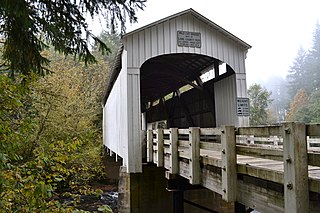
Lowell Bridge is a covered bridge in Lowell, Oregon, United States. The original bridge was built in 1907. The current bridge was built in 1945. It was listed on the National Register of Historic Places in 1979.

The Earnest Bridge, located near Marcola, Oregon, is listed on the National Register of Historic Places. The name is spelled Ernest Bridge in some documents, including the NRHP listing, but spelled Earnest Bridge in the NRHP nomination and in signage on the bridge itself.

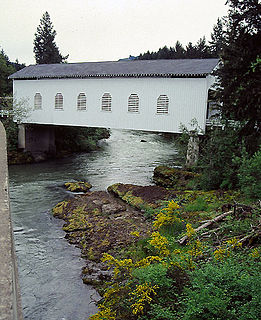
The Lake Creek Bridge also known as the Nelson Mountain Bridge, near Greenleaf, in the U.S. state of Oregon, is listed on the National Register of Historic Places. The 105-foot (32 m) covered bridge, built in 1928, carries Nelson Mountain Road over Lake Creek in Lane County.

The Coyote Creek Bridge near Crow, Oregon, United States, is listed on the National Register of Historic Places. The 60-foot (18 m) Howe truss structure, built in 1922, carries Battle Creek Road over Coyote Creek.
The Deadwood Creek Bridge is a covered bridge in western Lane County in the U.S. state of Oregon. Built in 1932, the 105-foot (32 m) Howe truss structure carries Deadwood Loop Road over Deadwood Creek. The crossing lies upstream of the rural community of Deadwood in the Siuslaw National Forest of the Central Oregon Coast Range. The bridge was added to the National Register of Historic Places in 1979.

The Parvin Bridge is a covered bridge located in Lane County, Oregon, U.S. near Dexter. It was built in 1921 as a single-lane 75-foot (23 m) bridge across Lost Creek, a tributary of the Middle Fork Willamette River.

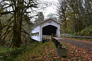
The Wendling Bridge is a covered bridge in Lane County in the U.S. state of Oregon. The 60-foot (18 m) Howe truss structure carries Wendling Road over Mill Creek in the unincorporated community of Wendling. Built in 1938, the bridge was added to the National Register of Historic Places in 1979.

The Harris Bridge, located near Wren, Oregon, is a covered bridge listed on the National Register of Historic Places.
Lost Creek is a tributary of the Middle Fork Willamette River in the U.S. state of Oregon. It begins in the Cascade Range foothills between Dorena Lake and Lookout Point Lake and flows generally north to meet the river downstream of Lowell. Along the way, it passes by the rural community of Dexter, then under Oregon Route 58, and through part of Elijah Bristow State Park. Named tributaries of Lost Creek from source to mouth are Guiley, Gossage, Carr, Middle, Anthony, and Wagner creeks.


