National Register of Historic Places listings in Baker County, Oregon
Last updated
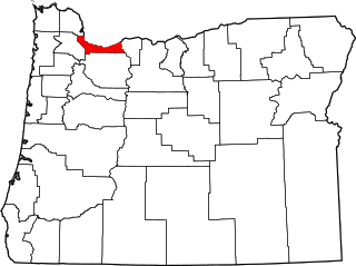
Location of Baker County in Oregon
This list presents the full set of buildings, structures, objects, sites, or districts designated on the National Register of Historic Places in Baker County, Oregon, and offers brief descriptive information about each of them. The National Register recognizes places of national, state, or local historic significance across the United States.[1] Out of over 90,000 National Register sites nationwide,[2]Oregon is home to over 2,000,[3] and 14 of those are found partially or wholly in Baker County.
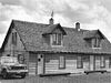
This rustic-styled cabin and garage were built for the Forest Service by the Civilian Conservation Corps around 1935. They recall both the CCC's Depression-era relief programs, and the use of architecture to express the Forest Service's identity and mission in the first half of the 20th century.[7]
This gold dredge was used in placer mining along the Powder River from 1935 to 1954, representing a period of mining by dredge that began in 1913. The last of three dredges in the Sumpter Valley in that period, it produced some $4.5 million in gold in its career. It is preserved as a museum.[8][9]
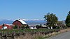
This narrow-gauge railway, built in stages between 1890 and 1910, was intimately connected to the logging industry in the Blue Mountains, and also served the mining, livestock, and agricultural industries. About half of the total roadbed of the railway is included in the historic district, along with several spurs, station sites, sawmill sites, and rolling stock. Although most of the line was abandoned in 1933 and 1946 and rails removed, a small section continues to operate as a heritage railway.[10]
The Sumpter Valley Railway, or Sumpter Valley Railroad, is a 3 ft narrow gauge heritage railroad located in Baker County, in the U.S. state of Oregon. Built on a right-of-way used by the original railway of the same name, it carries excursion trains on a roughly 5-mile (8.0 km) route between McEwen and Sumpter. The railroad has two steam locomotives and several other pieces of rolling stock. Passenger excursion trains operate on weekends and holidays from Memorial Day through the end of September.
This is a list of properties and historic districts in Oregon that are listed on the National Register of Historic Places. There are listings in all of Oregon's 36 counties.
The following list presents the full set of National Register of Historic Places listings in Multnomah County, Oregon. However, please see separate articles for listings in each of Portland's six quadrants.
The Sumpter Valley Gold Dredge is a historic gold dredge located in Sumpter, in the U.S. state of Oregon. Gold was discovered in Sumpter in 1862. Three gold dredges were put into service in the Sumpter Valley district between 1912 and 1934.
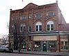
Sumpter Valley Railway Passenger Station was the westernmost station on the Sumpter Valley Railway, which ran 80 miles (130 km) from Baker City to Prairie City in the U.S. state of Oregon. The line reached Prairie City in 1910 but was abandoned in 1933, and the station became a private dwelling. Since 1984, the renovated station has housed the collections of the DeWitt Museum, including railway artifacts from the late 19th and early 20th centuries.
↑ Oregon Parks and Recreation Department, Oregon Historic Sites Database, retrieved August 6, 2015. Note that a simple count of National Register records in this database returns a slightly higher total than actual listings, due to duplicate records. A close reading of detailed query results is necessary to arrive at the precise count.
↑ Numbers represent an alphabetical ordering by significant words. Various colorings, defined here, differentiate National Historic Landmarks and historic districts from other NRHP buildings, structures, sites or objects.
↑ The eight-digit number below each date is the number assigned to each location in the National Register Information System database, which can be viewed by clicking the number.
This page is based on this Wikipedia article Text is available under the CC BY-SA 4.0 license; additional terms may apply. Images, videos and audio are available under their respective licenses.