Dorfgastein

Last updated
Dorfgastein
Dorfgastein - Ortsansicht.JPG
View of Dorfgastein
AUT Dorfgastein COA.svg
Coat of arms
Austria adm location map.svg
Red pog.svg
Dorfgastein
Location within Austria
Coordinates: 47°14′33″N13°16′0″E / 47.24250°N 13.26667°E / 47.24250; 13.26667 Coordinates: 47°14′33″N13°16′0″E / 47.24250°N 13.26667°E / 47.24250; 13.26667
Country Austria
State Salzburg
District St. Johann im Pongau
Government
   Mayor Rudolf Trauner (SPÖ)
Area
[1]
  Total54.09 km2 (20.88 sq mi)
Elevation
812 m (2,664 ft)
Population
 (2018-01-01) [2]
  Total1,614
  Density30/km2 (77/sq mi)
Time zone UTC+1 (CET)
  Summer (DST) UTC+2 (CEST)
Postal code
5632
Area code 06433
Vehicle registration JO
Website www.dorfgastein.at

Dorfgastein is a municipality in St. Johann im Pongau District, in the Austrian state of Salzburg.

Contents

Geography

It is located on the northern entrance of the Gastein Valley within the Hohe Tauern mountain range, south of the broader Salzach Valley. It is accessible by the Tauern Railway leading up to Bad Hofgastein and Bad Gastein, crossing the Alpine crest via the Tauerntunnel. The municipality consists of the cadastral communities of Dorfgastein and Klammstein.

History

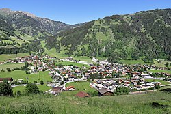
The bridle path through the Gastein gorge up to the Tauern passes was first mentioned in a 1212 deed. The village itself (ze Dorff), then part of the Archbishopric of Salzburg, was first documented in the oldest Gastein mining regulations of 1342. The St. Rupert parish church was founded in 1350.

Klammstein Castle Dorfgastein - Burg Klammstein (4).JPG
Klammstein Castle

For centuries Klammstein Castle erected high above the historic trade route in the 12th century, served as the administrative seat of the archbishops' keeper of the Gastein Valley. Temporarily held by the Bavarian counts of Ortenburg, it was acquired by the Salzburg archbishop Philip of Spanheim in 1251, whose ministeriales imposed tolls and secured the area at the valley entrance. The surrounding estates were finally incorporated into the Archbishopric of Salzburg in 1297 with the consent of the Bavarian dukes Otto III and Stephen I. The administrative seat was relocated to neighbouring Hofgastein, after Archbishop Leonhard von Keutschach transferred the castle to his relatives as a gift. In 1589 Archbishop Wolf Dietrich Raitenau allowed the demolition of the outer walls.

In 1735 the first school opened in Dorfgastein (with electric lighting in the classes from 1921). A telegraph office was established in 1893. A new school building was inaugurated in 1927.

The first Dorfgastein ski lift opened in 1959. Today the local Großarltal-Dorfgastein ski area is part of the larger Ski Amadé region.

Related Research Articles

Salzburg (state) State in Austria

Salzburg is a state (Land) of Austria. It is officially named Land Salzburg, colloquially Salzburgerland, to distinguish it from its eponymous capital Salzburg city and as such is the only state to be named after its capital. By its centuries-long history as an independent Prince-Bishopric, Salzburg's tradition differs from the other Austrian lands.

Werfen Place in Salzburg, Austria

Werfen is a market town in the district of St. Johann im Pongau, in the Austrian state of Salzburg. It is mainly known for medieval Hohenwerfen Castle and the Eisriesenwelt ice cave, the largest in the world.

Bad Gastein Place in Salzburg, Austria

Bad Gastein is a spa town in the district of St. Johann im Pongau, in the Austrian state of Salzburg. Picturesquely situated in a high valley of the Hohe Tauern mountain range, it is known for the Gastein Waterfall and a variety of Belle Époque hotel buildings.

Mittersill Place in Salzburg, Austria

Mittersill is a city in the federal state of Salzburg, Austria, in the Pinzgau region of the Alps. It is located on the Salzach River. It has a population of 5,408 as of 2011.

Gmünd, Carinthia Place in Carinthia, Austria

Gmünd in Kärnten is a historic town in the district of Spittal an der Drau, in the Austrian state of Carinthia.

Mauterndorf Place in Salzburg, Austria

Mauterndorf is a market town of the Tamsweg District in the Austrian state of Salzburg. The municipality also comprises the Katastralgemeinden Faningberg, Neuseß and Steindorf.

Tamsweg Place in Salzburg, Austria

Tamsweg is a market town in the Austrian state of Salzburg near the border with Styria. It is the administrative centre of the eponymous Tamsweg District (Bezirk) and the largest town of the Salzburg Lungau region.

Bad Hofgastein Place in Salzburg, Austria

Bad Hofgastein is a market town in the district of St. Johann im Pongau, in the Austrian state of Salzburg. The spa town is located in the Gastein Valley, a large ski resort belonging to the Ski Amadé network.

Saalfelden Place in Salzburg, Austria

Saalfelden am Steinernen Meer is a town in the district of Zell am See in the Austrian state of Salzburg. With approximately 16,000 inhabitants, Saalfelden is the district's largest town and the third of the federal state after Salzburg and Hallein.

Radstadt Place in Salzburg, Austria

Radstadt is a historic town in the district of St. Johann im Pongau in the Austrian state of Salzburg.

Krems, Carinthia Place in Carinthia, Austria

Krems in Kärnten is a municipality in the district of Spittal an der Drau in Carinthia in Austria.

Mallnitz Place in Carinthia, Austria

Mallnitz is a municipality in the Spittal an der Drau District in Carinthia, Austria.

Obervellach Place in Carinthia, Austria

Obervellach is a market town in the district of Spittal an der Drau, in the Austrian state of Carinthia.

Matrei in Osttirol Place in Tyrol, Austria

Matrei in Osttirol is a market town in the Lienz District in the Austrian state of Tyrol. It is situated about 29 km (18 mi) north of Lienz within the Hohe Tauern mountain range of the Central Eastern Alps. Its municipal area comprises parts of the Granatspitze Group and the Venediger Group, with the Großvenediger peak as its highest point. The population largely depends on tourism, seasonal agriculture and forestry.

Sankt Michael im Lungau Place in Salzburg, Austria

Sankt Michael im Lungau is a market town in the district of Tamsweg in the Austrian state of Salzburg.

Wagrain Place in Salzburg, Austria

Wagrain is a market town in the St. Johann im Pongau District in the Austrian state of Salzburg. It is located in a high valley stretching from the Salzach at Sankt Johann in the west to the Enns river in the east. The municipality includes the Katastralgemeinden Hof, Hofmarkt, Schwaighof and Vorderkleinarl. The population is about 3,020.

Untertauern Place in Salzburg, Austria

Untertauern is a municipality in the district of St. Johann im Pongau in the Austrian state of Salzburg.

Schwarzach im Pongau Place in Salzburg, Austria

Schwarzach im Pongau is a market town in the St. Johann im Pongau District in the Austrian state of Salzburg.

Hüttschlag Place in Salzburg, Austria

Hüttschlag is a municipality in the district of St. Johann im Pongau in the Austrian state of Salzburg.

Grödig Place in Salzburg, Austria

Grödig is a market town of Salzburg-Umgebung District in the state of Salzburg in Austria.

References

  1. "Dauersiedlungsraum der Gemeinden Politischen Bezirke und Bundesländer - Gebietsstand 1.1.2018". Statistics Austria. Retrieved 10 March 2019.
  2. "Einwohnerzahl 1.1.2018 nach Gemeinden mit Status, Gebietsstand 1.1.2018". Statistics Austria. Retrieved 9 March 2019.