Central line of mountains that forms the divide of the Alps
Main chain of the Alps
The main chain of the Alps, also called the Alpine divide is the central line of mountains that forms the drainage divide of the range. Main chains of mountain ranges are traditionally designated in this way, and generally include the highest peaks of a range. The Alps are something of an unusual case in that several significant groups of mountains are separated from the main chain by sizable distances. Among these groups are the Dauphine Alps, the Eastern and Western Graians, the entire Bernese Alps, the Tödi, Albula and Silvretta groups, the Ortler and Adamello ranges, and the Dolomites of Veneto and South Tyrol, as well as the lower Alps of Vorarlberg, Bavaria, and Salzburg.
The Alpine Divide is defined for much of its distance by the watershed between the drainage basin of the Po in Italy on one side, with the other side of the divide being formed by the Rhone, the Rhine and the Danube. Further east, the watershed is between the Adige and the Danube, before heading into Austria and draining on both sides into the Danube. For much of its distance the watershed lies on or close to the Italian border, although there are numerous deviations, notably, the Swiss canton of Ticino which lies south of the range in the Po river basin.
For only a small portion of its total distance does the Alpine divide form a part of the main European watershed, in the central section where the watershed is between the Po and the Rhine.
From the Maloja Pass (1,815 m) the main watershed dips to the south-east for a short distance, and then runs eastwards and nearly over the highest summit of the Bernina Range, Piz Bernina (4,049 m), to the Bernina Pass. From here the main chain is less well defined, it rises to Piz Paradisin (3,302 m), beyond which it runs slightly north-east, east of the Italian resort of Livigno, past Fraele Pass (1,952 m) and the source of the Adda, traverses Piz Murtarol (3,180 m) and Monte Forcola, where is the tripoint between the Danube, Po and Adige basins,[3] then falls to the Ofen Pass (2,149 m), soon heads north and rises once more in Piz Sesvenna (3,204 m).
The Reschen Pass (1,504 m) marks a break in the continuity of the Alpine chain. The deep valley, the Vinschgau of the upper Adige, is one of the most remarkable features in the orography of the Alps. The little Reschen Lake, which forms the chief source of the Adige, is only 4 metres below the Pass, and 8km from the Inn valley. Eastward of this pass, the main chain runs north-east to the Brenner Pass along the snowy crest of the Ötztal, the highest point being the Weißkugel (3,739 m), then crossing the Timmelsjoch (2,474 m) and rising again in Stubai Alps Both the highest summits of the Ötztal and the Stubai, the Wildspitze (3,774 m) and the Zuckerhütl (3,505 m), stand a little to the north.
The Brenner (1,370 m) is the lowest of all the great road passes across the core part of the main chain and has always been the chief means of communication between Germany and Italy. For some way beyond it, the watershed runs eastwards over the highest crest of the Zillertal Alps, which attains 3,510 metres in the Hochfeiler. But, a little farther, at the Dreiherrnspitze (3,499 m), the chain splits: the main watershed between the Black Sea and the Mediterranean heads south, along the Rieserferner Group to the Dolomites, and Julian Alps.
Starting from the Bocchetta di Altare or di Colle di Cadibona (west of Savona), the main chain extends first south-west, then north-west to the Col de Tenda, though nowhere rising much beyond the zone of coniferous trees. Beyond the Col de Tenda the direction is first roughly west, then north-west to the Rocca dei Tre Vescovi (2,840 m), just south of the Enciastraia (2,955 m), several peaks of about 3,000 metres rising on the watershed, though the highest of all, the Punta dell'Argentera (3,297 m) stands a little way to its north. From the Rocher des Trois Eveques the drainage divide runs due north for a long distance, though of the two loftiest peaks of this region one, the Aiguille de Chambeyron (3,412 m), is just to the west, and the other, the Monviso (3,841m), is just to the east of the divide. From the head of the Val Pellice the main chain runs north-west and diminishes much in average height until it reaches the Mont Thabor (3,178 m), which forms the apex of a salient angle which the main chain here presents towards the west. From here the divide extends eastwards, culminating in the Aiguille de Scolette (3,505 m), but makes a great curve to the north-west and back to the south-east before rising in the Rocciamelone (3,509 m). From there the direction taken is north as far as the eastern summit (3,619 m) of the Levanna, the divide rising in a series of snowy peaks, though the loftiest point of the region, the Pointe de Charbonnel (3,760 m), stands a little to the west. Once more the chain bends to the north-west, rising in several lofty peaks (the highest is the Aiguille de la Grande Sassière, 3,751 m), before attaining the considerable depression of the Little St Bernard Pass.
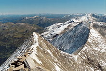
View of the Witenwasserenstock with the tripoint between the Rhone, Rhine, and Po basins (center left)
The divide then briefly turns north to the Col de la Soigne, and then north-east along the crest of the Mont Blanc chain, which culminates in the peak of Mont Blanc (4,810 m),[2] the highest in the Alps. A number of high peaks line the divide, notably the Grandes Jorasses (4,208 m) before it reaches Mont Dolent (3,823 m), where France, Italy and Switzerland meet. From there, after a short dip to the south-east, the chain takes, near the Great St. Bernard Pass, a generally eastern direction that it maintains until it reaches Monte Rosa, where it bends northwards, making one small dip to the east to the Simplon Pass. It is in the portion of the watershed between the Grande St Bernard Pass and the Simplon that the main chain maintains a greater average height than in any other part. But, though it rises in a number of lofty peaks, such as the Mont Vélan (3,727 m), the Matterhorn (4,478 m), the Lyskamm (4,533 m), the Nord End of Monte Rosa (4,575 m), and the Weissmies (4,023 m), many of the highest points of the region, such as the Grand Combin (4,314 m), the Dent Blanche (4,357 m), the Weisshorn (4,505 m), the true summit or Dufourspitze (4,634 m) of Monte Rosa itself, and the Dom (4,545 m), all rise on its northern slope and not on the main chain. On the other hand, the chain between the Grande St Bernard and the Simplon sinks at barely half a dozen points below a level of 3,000 metres.
The Simplon Pass (1.994 m) corresponds to a change in the main chain: the peaks and passes are lower, but as far as the Splugenpass, all the highest summits rise on the divide. From there to the St. Gotthard pass (2,106 m) the divide runs north-east, crossing Monte Leone (3,533 m), and Pizzo Rotondo (3,192 m). Near the Witenwasserenstock is the point where the basin of the Po, the Rhine and the Rhone meet, and the European Watershed joins the Alpine divide. From the St. Gotthard to the Maloja the watershed between the basins of the Rhine and Po runs in a generally easterly direction. It goes over Passo del Lucomagno (1,915 m), across Scopi (3,200 m), Piz Medel (3,210 m) and Piz Terri (3,149 m), where it turns towards the south to the Rheinwaldhorn (3,402m). Here the divide veers back east over the Vogelberg (3,220 m) to the San Bernardino Pass (2,067 m), then over the Pizzo Tambo (3,279 m), the Splugenpass (2,114 m) and Piz Timun (3,209 m). From here the divide heads south again to Pizzo Stella (3,163 m) and then east over Pizz Gallagiun (3,107 m), to where, near the Lunghin pass, it reaches the main triple divide of the Alps: where water can flow to the Atlantic, the Mediterranean or the Black Sea. The main European watershed leaves the Alpine divide here, heading north, while the divide continues east to the Maloja Pass (1,815 m).
Glaciers
The main chain has more glaciers and eternal snow than the independent or external ranges. The longest of these were both 14.9 kilometres (9+1⁄4 miles) a century ago, the Mer de Glace at Chamonix (now 7.6km or 4+3⁄4mi) and the Gorner Glacier at Zermatt (now 12.5km or 7+3⁄4mi). In the Eastern Alps the longest glacier was the Pasterze Glacier (8.4km or 5+1⁄4mi in 1911), which is not near the true main watershed, though it clings to the slope of the Grossglockner (3,798 m) in the Hohe Tauern range east of the Dreiherrenspitze. But two other long glaciers in the Eastern Alps (the Hintereis, and the Gepatsch) are both in the Ötztal Alps, and so are close to the true main watershed.
The Alps are one of the highest and most extensive mountain ranges in Europe, stretching approximately 1,200 km (750 mi) across eight Alpine countries : Monaco, France, Switzerland, Italy, Liechtenstein, Germany, Austria and Slovenia.
The Lepontine Alps are a mountain range in the north-western part of the Alps. They are located in Switzerland and Italy.
The Alpine region of Switzerland, conventionally referred to as the Swiss Alps, represents a major natural feature of the country and is, along with the Swiss Plateau and the Swiss portion of the Jura Mountains, one of its three main physiographic regions. The Swiss Alps extend over both the Western Alps and the Eastern Alps, encompassing an area sometimes called Central Alps. While the northern ranges from the Bernese Alps to the Appenzell Alps are entirely in Switzerland, the southern ranges from the Mont Blanc massif to the Bernina massif are shared with other countries such as France, Italy, Austria and Liechtenstein.
The Glarus Alps are a mountain range in central Switzerland. They are bordered by the Uri Alps and the Schwyz Alps to the west, the Lepontine Alps to the south, the Appenzell Alps to the northeast. The eastern part of the Glarus Alps contains a major thrust fault that was declared a geologic UNESCO World Heritage Site.
The Pennine Alps, sometimes referred to as the Valais Alps, are a mountain range in the western part of the Alps. They are located in Italy and Switzerland (Valais).
The Tödi, is a mountain massif and with the mountain peak Piz Russein the highest mountain in the Glarus Alps and the highest summit in the canton of Glarus, Switzerland. It is located on the border between the cantons of Graubünden, to the south, and Glarus, to the north, close to the point where those two cantons meet the canton of Uri, to the west. Although not the culminating point of Graubünden, it is its highest peak outside the Bernina range.
This article lists the principal mountain passes and tunnels in the Alps, and gives a history of transport across the Alps.
The Inn is a river in Switzerland, Austria and Germany. The 518 km (322 mi) long river is a right tributary of the Danube, being the third largest tributary of the Danube by discharge. The highest point of its drainage basin is the summit of Piz Bernina at 4,049 m (13,284 ft). The Engadine, the valley of the En, is the only Swiss valley whose waters end up in the Black Sea.
The Central Eastern Alps, also referred to as Austrian Central Alps or just Central Alps, comprise the main chain of the Eastern Alps in Austria and the adjacent regions of Switzerland, Liechtenstein, Italy and Slovenia. South of them is the Southern Limestone Alps.
Piz Bernina is the highest mountain in the Eastern Alps, the highest point of the Bernina Range, and the highest peak in the Rhaetian Alps. It rises 4,048 m (13,281 ft) and is located south of Pontresina in the Bernina Region and near the major Alpine resort of St. Moritz, in the Engadin valley. It is also the most easterly mountain higher than 4,000 m (13,000 ft) in the Alps, the highest point of the Swiss canton of Grisons, and the fifth-most prominent peak in the Alps. Although the summit lies within Switzerland, the massif is on the border with Italy. The "shoulder" known as La Spedla is the highest point in the Italian Lombardy region.
The main European watershed is the drainage divide ("watershed") which separates the basins of the rivers that empty into the Atlantic Ocean, the North Sea and the Baltic Sea from those that feed the Mediterranean Sea, the Adriatic Sea and the Black Sea. It stretches from the tip of the Iberian Peninsula at Gibraltar in the southwest to the endorheic basin of the Caspian Sea in Russia in the northeast.
The Alps form a large mountain range dominating Central Europe, including parts of Italy, France, Switzerland, Liechtenstein, Austria, Slovenia, Germany and Hungary.
The Eastern Alps are usually defined as the area east of a line from Lake Constance and the Alpine Rhine valley, up to the Splügen Pass at the Alpine divide, and down the Liro River to Lake Como in the south. The peaks and mountain passes are lower than the Western Alps, while the range itself is broader and less arched.
The Rheinwaldhorn is the highest point in the Swiss canton of Ticino at 3,402 metres above sea level. It lies on the border between the cantons of Graubünden and Ticino, in the Adula massif, part of the St. Gotthard massif of the Adula Alps in southern Switzerland.
Piz Kesch (German) or Piz d'Es-cha (Rumantsch) is a peak in the Albula Alps of the Rhaetian Alps in Switzerland. At 3,418 metres (11,214 ft), it is the highest peak in the Albula Alps and the municipality of Bergün, Grisons.
SOIUSA is a classification system of the Alps from the geographic and toponomastic point of view. It was designed by Sergio Marazzi, Italian researcher and author of the Orographic Atlas of the Alps SOIUSA. His book was presented with the patronage of the Italian Alpine Club on 23 Jan 2006, but has yet to receive any formal acceptance.
Three-thousanders are mountains with a height of between 3,000 metres (9,800 ft), but less than 4,000 metres (13,000 ft) above sea level. Similar terms are commonly used for mountains of other height brackets e. g. four-thousanders or eight-thousanders. In Britain, the term refers to mountains above 3,000 feet (910 m).
The border between the modern states of Switzerland and Italy extends for 744 kilometres (462 mi), from the French-Swiss-Italian tripoint at Mont Dolent in the west to the Austrian-Swiss-Italian tripoint near Piz Lad in the east. Much of the border runs across the High Alps, rising above 4,600 metres (15,100 ft) as it passes east of Dufourspitze, but it also descends to the lowest point in Switzerland as it passes Lago Maggiore at below 200 metres (660 ft).
Lombardy is an administrative region of Italy that is split into four geographic regions — mountains, alpine forest, and the upper and lower plains south of the Po river. These are crossed and dotted by dozens of rivers and lakes, the latter of which include some of the largest in Italy. The territory is the fourth largest in Italy by surface area with 24,000 square kilometres (9,300 sq mi).
The Italian geographic region, Italian physical region or Italian region is a geographical region of Southern Europe delimited to the north by the mountain chains of the Alps. This subregion is composed of a peninsular and continental part and an insular part. Located between the Balkan Peninsula and the Iberian Peninsula, it protrudes into the centre of the Mediterranean Sea and overlooks the Adriatic Sea, the Ionian Sea, the Ligurian Sea, the Sardinian Channel, the Sea of Corsica, the Sea of Sardinia, the Strait of Sicily, and the Tyrrhenian Sea.
This page is based on this Wikipedia article Text is available under the CC BY-SA 4.0 license; additional terms may apply. Images, videos and audio are available under their respective licenses.