
The Orange Free State was an independent Boer sovereign republic under British suzerainty in Southern Africa during the second half of the 19th century, which ceased to exist after it was defeated and surrendered to the British Empire at the end of the Second Boer War in 1902. It is one of the three historical precursors to the present-day Free State province.

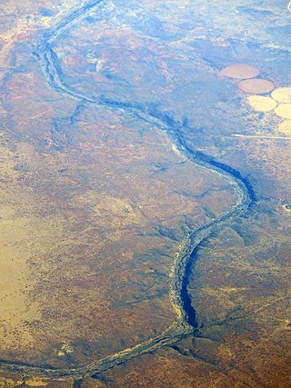
The Orange River is a river in Southern Africa. It is the longest river in South Africa. With a total length of 2,432 km (1,511 mi), the Orange River Basin extends from Lesotho into South Africa and Namibia to the north. It rises in the Drakensberg mountains in Lesotho, flowing westwards through South Africa to the Atlantic Ocean. The river forms part of the international borders between South Africa and Lesotho and between South Africa and Namibia, as well as several provincial borders within South Africa. Except for Upington, it does not pass through any major cities. The Orange River plays an important role in the South African economy by providing water for irrigation and hydroelectric power. The river was named the Orange River in honour of the Dutch ruling family, the House of Orange, by the Dutch explorer Robert Jacob Gordon. Other names include simply the word for river, in Khoekhoegowab orthography written as !Garib, which is rendered in Afrikaans as Gariep River with the intrusion of a velar fricative in place of the alveolar click, Groote River or Senqu River, derived from ǂNū "Black". It is known in isiZulu as isAngqu.

The Vaal River is the largest tributary of the Orange River in South Africa. The river has its source near Breyten in Mpumalanga province, east of Johannesburg and about 30 kilometres (19 mi) north of Ermelo and only about 240 kilometres (150 mi) from the Indian Ocean. It then flows westwards to its confluence with the Orange River southwest of Kimberley in the Northern Cape. It is 1,458 kilometres (906 mi) long, and forms the border between Mpumalanga, Gauteng and North West Province on its north bank, and the Free State on its south.

The Province of the Transvaal, commonly referred to as the Transvaal, was a province of South Africa from 1910 until 1994, when a new constitution subdivided it following the end of apartheid. The name "Transvaal" refers to the province's geographical location to the north of the Vaal River. Its capital was Pretoria, which was also the country's executive capital.

The Boer republics were independent, self-governing republics formed by Dutch-speaking inhabitants of the Cape Colony and their descendants. The founders – variously named Trekboers, Boers, and Voortrekkers – settled mainly in the middle, northern, north-eastern and eastern parts of present-day South Africa. Two of the Boer republics achieved international recognition and complete independence: the South African Republic and the Orange Free State. The republics did not provide for the separation of church and state, initially allowing only the Dutch Reformed Church, and later also other Protestant churches in the Calvinist tradition. The republics came to an end after the Second Boer War of 1899–1902, which resulted in British annexation and later incorporation of their lands into the Union of South Africa.

The Northern Cape is the largest and most sparsely populated province of South Africa. It was created in 1994 when the Cape Province was split up. Its capital is Kimberley. It includes the Kalahari Gemsbok National Park, part of the Kgalagadi Transfrontier Park and an international park shared with Botswana. It also includes the Augrabies Falls and the diamond mining regions in Kimberley and Alexander Bay.

The N1 is a national route in South Africa that runs from Cape Town through Bloemfontein, Johannesburg, Pretoria and Polokwane to Beit Bridge on the border with Zimbabwe. It forms the first section of the famed Cape to Cairo Road.
Bothaville is a maize farming town situated near the Vaal River in the Lejweleputswa DM of the Free State province, South Africa. It is situated 60 km east of the Vaal, on the bank of its Vals River tributary. Bothaville and the adjacent Kgotsong township have a total of approximately 46,000 residents.

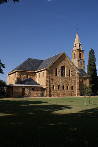
Parys, resort town, northern Free State province, South Africa. It is situated on the southern bank of the Vaal River. The name of the city is the Afrikaans translation of Paris. The origin of the name 'Parys' is attributed to German surveyor Schilbach, who named it after the city of Paris because of the similarity between its location next to the Vaal River and that of Paris on the River Seine. The area of Parys also includes the two townships of Tumahole and Schonkenville.
Christiana is an agricultural town of about 3,000 inhabitants on the banks of the Vaal River in North West province, South Africa. The town is located on the N12 national route between Bloemhof and Warrenton, on the way to Kimberley. It is the administrative centre and seat of Lekwa-Teemane Local Municipality.

The Highveld is the portion of the South African inland plateau which has an altitude above roughly 1500 m, but below 2100 m, thus excluding the Lesotho mountain regions to the south-east of the Highveld. It is home to some of the country's most important commercial farming areas, as well as its largest concentration of metropolitan centres, especially the Gauteng conurbation, which accommodates one-third of South Africa's population.
Barkly West is a town in the Northern Cape province of South Africa, situated on the north bank of the Vaal River west of Kimberley.

Warrenton is an agricultural town of approximately 22,588 people in the Northern Cape province of South Africa, situated 70 kilometres (40 mi) north of Kimberley on the Vaal River.
Windsorton is an agricultural town situated in the Vaalharts Irrigation Scheme on the banks of the Vaal River in the Northern Cape province of South Africa.

The Harts River is a northern tributary of the Vaal River, which in turn is the largest tributary of the Orange River. Its source is in the North West Province, but the greater part of its basin is located in the Northern Cape Province, which it enters a few kilometers downstream from the Taung Dam.
The Riet River is a westward-flowing tributary of the Vaal River in central South Africa. In precolonial times the Riet was known as the Gama-!ab, a !Kora name meaning 'muddy'. Its main tributary is the Modder River and after the confluence the Riet River flows westwards to meet the Vaal.
General Sir Robert Percy Douglas, 4th Baronet was a British Army officer who became Lieutenant Governor of Jersey.
Douglas Weir is a dam on the Vaal River, near Douglas, Northern Cape, South Africa. It was established in 1896 and raised in 1977.
Sydney on Vaal is a ghost-town in Frances Baard District Municipality in the Northern Cape province of South Africa. The village lies 30 km northwest of Barkly West and several kilometres south of Delportshoop. It was founded in 1902 and is variously said to be named after Sidney Mendelssohn, Director of the Vaal River Diamond and Exploration Company which owned the land, as well as after its situation on the Vaal River, and after Sidney Shippard, Acting Attorney of the Executive Council of Griqualand West in 1872.
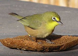
The Orange River white-eye is a species of bird in the family Zosteropidae, which is native to Namibia and South Africa. It was formerly deemed conspecific with the Cape white-eye, but the two species occur sympatrically in central South Africa, and they are genetically distinct.


