Related Research Articles

The Peak District is an upland area in England at the southern end of the Pennines. Mostly in Derbyshire, it extends into Cheshire, Greater Manchester, Staffordshire, West Yorkshire and South Yorkshire. It includes the Dark Peak, where moorland is found and the geology gritstone, and the White Peak, a limestone area with valleys and gorges. The Dark Peak forms an arc on the north, east and west sides; the White Peak covers central and southern tracts. The historic Peak District extends beyond the National Park, which excludes major towns, quarries and industrial areas. It became the first of the national parks of England and Wales in 1951. Nearby Manchester, Stoke-on-Trent, Derby and Sheffield send millions of visitors – some 20 million live within an hour's ride. Inhabited from the Mesolithic era, it shows evidence of the Neolithic, Bronze and Iron Ages. Settled by the Romans and Anglo-Saxons, it remained largely agricultural; mining arose in the Middle Ages. Richard Arkwright built cotton mills in the Industrial Revolution. As mining declined, quarrying grew. Tourism came with the railways, spurred by the landscape, spa towns and Castleton's show caves.

The White Peak, also known as the Low Peak, is a limestone plateau that forms the central and southern part of the Peak District in England. It is mostly between 270 metres (900 ft) and 430 metres (1,400 ft) above sea-level and is enclosed by the higher altitude Dark Peak to the west, north and east.

The Cromford and High Peak Railway (C&HPR) was a standard-gauge line between the Cromford Canal wharf at High Peak Junction and the Peak Forest Canal at Whaley Bridge. The railway, which was completed in 1831, was built to carry minerals and goods through the hilly rural terrain of the Peak District within Derbyshire, England. The route was marked by a number of roped worked inclines. Due to falling traffic, the entire railway was closed by 1967.

The High Peak Trail is a 17-mile (27 km) trail for walkers, cyclists and horse riders in the Peak District of England. Running from Dowlow (53.2059°N 1.8349°W), near Buxton, to High Peak Junction, Cromford (53.1004°N 1.5354°W), it follows the trackbed of the former Cromford and High Peak Railway, which was completed in 1831 to carry minerals and goods between the Cromford Canal wharf at High Peak Junction and the Peak Forest Canal at Whaley Bridge.

The Tissington Trail is a bridleway, footpath and cycleway in Derbyshire, England, along part of the trackbed of the former railway line connecting Ashbourne to Buxton. It takes its name from the village of Tissington, which it skirts. Opened in 1971, and now a part of the National Cycle Network, it stretches for 13 miles (21 km) from Parsley Hay (53.1706°N 1.7828°W) in the north to Ashbourne (53.0196°N 1.7397°W) in the south.
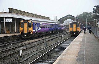
Buxton railway station serves the Peak District town of Buxton in Derbyshire, England. It is managed and served by Northern. The station is 25+3⁄4 miles (41.4 km) south east of Manchester Piccadilly and is the terminus of the Buxton Line.

Millers Dale is a valley on the River Wye in Derbyshire, England, where there is also a hamlet of the same name.

Eldon Hill is a hill in the Peak District National Park in the county of Derbyshire, England, 4 kilometres (2.5 mi) southwest of the village of Castleton. It is a 470-metre (1,540 ft) limestone hill whose pastureland is used for rough grazing, although a large proportion has been lost to limestone quarrying. It lies within the Castleton Site of Special Scientific Interest. Eldon Hill was formed when a bed of pure limestone was squeezed and upfolded by geological forces to form a dome; it is the highest limestone hill north of the River Wye.
Buxton Museum and Art Gallery focuses its collection on history, geology and archaeology primarily from the Peak District and Derbyshire.
The Ashbourne line was a 33+1⁄2 mi (53.9 km) railway from Buxton via Ashbourne to Uttoxeter. It was built by the London and North Western Railway using a section of the Cromford and High Peak Railway (C&HPR) and it joined the North Staffordshire Railway at Ashbourne, proceeding to Uttoxeter with a junction onto the main line at Rocester.

Higher Buxton railway station was opened in 1894 to the south east of Buxton, Derbyshire, on the LNWR line to Ashbourne and the south.
Hindlow railway station was opened for goods in 1833 near to Hindlow near King Sterndale to the south east of Buxton, Derbyshire on the Cromford and High Peak Railway and the LNWR line to Ashbourne and the south.

Dowlow Halt was opened in 1920 between Dowlow and Greatlow to the south east of Buxton, Derbyshire on the London and North Western Railway line to Ashbourne and the south.

The Buxton lime industry has been important for the development of the town of Buxton in Derbyshire, England, and it has shaped the landscape around the town.

The Derbyshire Dome is a geological formation across mid-Derbyshire in England.

The Wye Valley is the limestone valley of the River Wye in the White Peak of Derbyshire, England. The source of the River Wye is west of Buxton on Axe Edge Moor. One main channel runs underground through Poole's Cavern. The river flows though Buxton Pavilion Gardens and then along a culvert under the town centre. After leaving the flat area of central Buxton, the Wye Valley becomes distinct as a gorge running east for 10 miles (16 km) before the valley broadens at Ashford-in-the Water.

Bradwell Moor is a moorland hill above the village of Bradwell, Derbyshire in the Peak District. The summit is 471 metres (1,545 ft) above sea level.
Newhaven Tunnel was a railway tunnel located on the Cromford and High Peak Railway near the village of Newhaven in Derbyshire. Mostly used for moving mineral and quarry traffic. It closed in 1967 along with the rest of the line. And today, the tunnel and trackbed form part of the High Peak Trail.
Ladmanlow railway station was a minor railway station located on the Cromford and High Peak Railway near Buxton in Derbyshire. Located on a line mostly used for mineral and quarry traffic. It opened to passengers in 1855 and closed in 1876 due to relatively but not uncommon low usage. The goods station then closed in 1967 along with the rest of the line. And today, nothing remains of the station. It was also the terminus of the line originally for passengers until 1874 when it was extended to Buxton/Whaley Bridge. The trackbed now forms part of the A54 Road.
Bunsail railway station was a minor railway station located on the Cromford and High Peak Railway near Buxton in Derbyshire. Located on a line mostly used for mineral and quarry traffic. It opened to passengers in 1855 and closed in 1876 due to relatively but not uncommon low usage. The goods station then closed in 1967 along with the rest of the line. And today, nothing remains of the station. The trackbed and tunnel are still traceable on maps but have returned to mostly agriculture and minor roads.
References
- ↑ "Dowlow Quarry shows off its new fleet of Caterpillar machines)".
- ↑ "Buxton (Dowlow Quarry & Asphalt Plant)".
- ↑ Contributors, Ewan Crawford, John Furnevel. "Dowlow Quarry - RAILSCOT". www.railscot.co.uk.
{{cite web}}:|last=has generic name (help) - ↑ "Buxton (Dowlow Quarry & Asphalt Plant". Breedon Group.
- ↑ "Dowlow Works in The Peak District, Derbyshire, England by Jack Quick (26)". www.go4awalk.com.
- ↑ "Dowlow Works Limestone Mill information and photos". www.aditnow.co.uk.
Coordinates: 53°12′27″N1°50′53″W / 53.2076°N 1.8480°W
| | This Derbyshire location article is a stub. You can help Wikipedia by expanding it. |