The Cromford and High Peak Railway (C&HPR) was a standard-gauge line between the Cromford Canal wharf at High Peak Junction and the Peak Forest Canal at Whaley Bridge. The railway, which was completed in 1831, was built to carry minerals and goods through the hilly rural terrain of the Peak District within Derbyshire, England. The route was marked by a number of roped worked inclines. Due to falling traffic, the entire railway was closed by 1967.
One scheme that had been suggested would pass via Tansley, Matlock and Bakewell. In 1810, a prospectus was published for another route via Grindleford, Hope and Edale, but since it could only promise £6,000 a year, in return for an outlay of £500,000, it was received with little enthusiasm. The problem was not only carrying a canal over a height of around a thousand feet, but supplying it with water on the dry limestone uplands.
Finally Josias Jessop, the son of William Jessop, was asked to survey the route. He, his father and their former partner Benjamin Outram had gained wide experience in building tramways where conditions were unsuitable for canals, and that is what he suggested. Even so, as almost the first long-distance line at 33 miles (53km), it was a bold venture. Moreover, to its summit at Ladmanlow, it would climb a thousand feet from Cromford, making it one of the highest lines ever built in Britain.
An Act for making and maintaining a Railway or Tram Road from Cromford Canal, at or near to Cromford, in the Parish of Wirksworth, in the County of Derby, to the Peak Forest Canal, at or near to Whaley (otherwise Yardsley-cum-Whaley), in the County Palatine of Chester.
In 1825 the Cromford and High Peak Railway Act 1825 (6 Geo. 4. c. xxx) was obtained for a "railway or tramroad" to be propelled by "stationary or locomotive steam engines," which was remarkably prescient, considering few people considered steam locomotives to be feasible, and George Stephenson's Stockton and Darlington Railway was barely open in far-away County Durham.
Construction
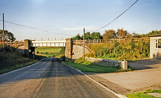
Middleton Incline today
The first part of the line from the wharf at High Peak Junction, on the Cromford Canal, to Hurdlow opened in 1830. From the canal it climbed over one thousand feet (305m) in five miles (8km), through three inclines ranging from 1 in 14 (7.1%) to 1 in 8 (12.5%): Sheep Pasture incline near Cromford and Middleton and Hopton inclines above Wirksworth. The line then proceeded up the relatively gentle Hurdlow incline at 1 in 16 (6.25%). The second half from Hurdlow to Whaley Bridge opened in 1832 descending through four more inclines, the steepest being 1 in 7 (14.3%). The highest part of the line was at Ladmanlow, a height of 1,266 feet (386m). For comparison, the present-day highest summit in England is Ais Gill at 1,169 feet (356m) on the Settle–Carlisle line, although the remaining, freight-only, stub of the CHPR at Dowlow Lime Works reaches a height of 1,250 feet (381m).
Fishbelly rail laid on stone blocks, a common form of early track construction, had the advantage of providing a continuous soft path between the rails that was suitable for horses
The railway was laid using so-called "fishbelly" rails supported on stone blocks, as was common in those days, rather than timber sleepers, since it would be powered by horses on the flat sections. On the nine inclined planes, stationary steam engines would be used, apart from the last incline into Whaley Bridge, which was counterbalanced and worked by a horse-gin. The engines, rails and other ironwork were provided by the Butterley Company. It would take around two days to complete the journey. It was laid to the Stephenson gauge of 4ft8+1⁄2in (1,435mm), rather than Outram's usual 4ft2in (1,270mm).
While its function was to provide a shorter route for Derbyshire coal than the Trent and Mersey Canal, it figured largely in early East Midlands railway schemes because it was seen as offering a path into Manchester for proposed lines from London. However, the unsuitability of cable railways for passengers became clear within a few years.
Part of the route included the Hopton Incline. This was a very steep section of the railway about a mile north of the small village of Hopton. It was originally worked by a stationary steam engine but was modified later to be adhesion worked by locomotives. At 1 in 14 (7%), it was the steepest in Britain and trains frequently had to be split and pulled up a few wagons at a time.
Dozens of small sidings were added along the length of the railway to accommodate the waggons that worked the line. Towards the Cromford end, between Sheep Pasture Top and Friden there were over 15 sidings, mostly grouped between Sheep Pasture and Longcliffe, primarily serving quarries. One was built in 1883 from Steeplehouse to serve the Middleton Quarry north of Wirksworth. The branch closed in 1967 but the trackbed was later used for the 18in (457mm)Steeple Grange Light Railway in 1985.
Towards the Whaley Bridge end of the line, another profusion of sidings lay between Dowlow Halt and Ladmanlow, mostly serving quarries and limeworks. This included some dozen sidings in the short section between Harpur Hill and Old Harpur.
The following table lists the inclines as originally built:[1]
The line had been built on the canal principle of following contours across the plateau and the many tight curves hampered operations in later years. Not only did the C&HPR have the steepest adhesion worked incline of any line in the country, the 1 in 14 of Hopton, it also had the sharpest curve, 55 yards (50m) radius through eighty degrees at Gotham.[6]
The C&HPR was leased by the London and North Western Railway in 1862, being taken over fully in 1887. By 1890 permission had been obtained to connect the line directly to Buxton by building a new line from Harpur Hill the two or three miles into the town centre, thus frustrating the Midland Railway's original plans for a route to Manchester.
The old north end of the line from Ladmanlow (a short distance from Harpur Hill) to Whaley Bridge via the Goyt Valley was largely abandoned in 1892, though the track bed is still visible in many places and one incline forms part of a public road.
Then, built by the LNWR, the branch line to Ashbourne was opened in 1899. This used the section of the C&HP line from Buxton as far as Parsley Hay, from where a single line ran south to Ashbourne, where it connected with the North Staffordshire Railway. The formation was constructed to allow for double tracking if necessary, but this never happened.
Operation
Engine shed at top of Sheep Pasture Incline, 1949Workshops and offices at High Peak Junction – the original southern terminus, before extension of the line to the former Midland Railway now the Derwent Valley Line
The line was worked by independent contractors until long after other lines, which had taken operations in house upon the introduction of locomotives. The line was initially under-capitalised because many of the subscribers did not meet their dues, and it was mainly funded by the Butterley Company, a major supplier and its main creditor. The final cost was £180,000, more than Jessop's estimate of £155,000, but still much cheaper than a canal. Nevertheless, the line never achieved a profit. Francis Wright, the Chairman, was later to say, in 1862 "We found ourselves getting into difficulties from the third year of our existence," and added it was clear in retrospect that the line "never had a remote chance of paying a dividend on the original shares."[9]
The railway's first steam locomotive arrived in 1841 in the shape of Peak, built by Robert Stephenson and Company. By 1860 the line had six more locomotives gradually displacing the horses. Because the inclines were too steep for adhesion traction by these early locomotives, they were hauled up and down the inclines, along with their trains, by static steam engines. Hemp rope or chain, initially used for hauling trains, was later replaced by steel cables.
The Cromford and High Peak Railway Act 1855 (18 & 19 Vict. c. lxxv) authorised the carriage of passengers. However the one train per day each way did little to produce extra revenue and, when a passenger was killed in 1877, the service was discontinued. The line's prosperity depended on that of the canals it connected but, by the 1830s, they were in decline. This was, to a degree, offset by the increase in the trade for limestone from the quarries.
There were, in fact, very few accidents. In 1857, the Cromford and Sheep Pasture inclines had been merged into one, and in 1888, a brake van parted from the train near the summit. Gathering speed, it was unable to round the curve into Cromford Wharf. It passed over both the canal and the double track railway line, and landed in a field. A catch pit was therefore installed near the bottom. This can still be seen from the A6[10] with a (more recent) wrecked wagon still in it.
The most serious accident occurred in 1937. The line was fairly level on the approach to the Hopton Incline and it was the custom to gain speed for the uphill gradient. There was a shallow curve immediately before and on this occasion the locomotive spread the track, rolled over and down the embankment with four wagons. The driver was killed and thereafter a speed limit of 40mph was strictly enforced.
During World War II, the line was used to transport bombs to the huge underground munitions store at RAF Harpur Hill. The railway line ran directly through the site.[11]
Demise
Traffic – by now almost exclusively from local quarries – was slowly decreasing during the Beeching era, the first section of the line being closed in 1963. This was the rope-worked 1 in 8 Middleton Incline. The Middleton Top-Friden section, including the 1 in 8 Sheep Pasture Incline and the Hopton Incline, closed on 21 April 1967[12] and Friden to Hindlow closed on 2 October 1967.[13]
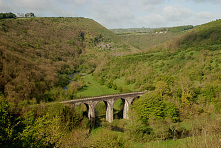
A cutting on the High Peak Trail.The summit of the former rope-worked railway incline at Middleton Top, now used as a footpath and cycle way.
In 1971 the Peak Park Planning Board and Derbyshire County Council bought part of the track bed (from Dowlow, near Buxton, to High Peak Junction, Cromford) and turned it into the High Peak Trail, now a national route of the National Cycle Network and popular with walkers, cyclists and horse riders.
The High Peak Trail and part of the Tissington Trail (see below) are now also designated as part of the Pennine Bridleway, a leisure route that starts at Middleton Top, near Cromford, and includes 73 miles (117km) through Derbyshire to the South Pennines.
The Middleton Incline Engine House has also been preserved, and the ancient engine once used to haul loaded wagons up is often demonstrated.[14] Another attraction along the route is the Steeple Grange Light Railway, a narrow-gauge railway running along the trackbed of a branch line off the C&HPR.
Near Cromford at the top of the town of Wirksworth the railway passed under Black Rocks, a popular gritstone climbing ground, and gave the name to the 'railway slab', a short tricky 'boulder problem' by the railway track.
At the hamlet of Parsley Hay, about 5 miles (8km) SW of Bakewell, the C&HPR/High Peak Trail is joined by the Tissington Trail, another route of the National Cycle Network, and formerly the railway line from Buxton to Ashbourne. This 13-mile (21km) recreational route runs from Parsley Hay to Ashbourne on a gently descending gradient.
Passenger services were introduced in stages with there being only one service a day each way between Cromford and Landmanlow in 1856. Stations were included at:
The following additional stations were added in 1874. However, this was short-lived and the line was closed to passengers along with the outlying halts and minor stations in 1876.
The High Peak Trail is a 17-mile (27 km) trail for walkers, cyclists and horse riders in the Peak District of England. Running from Dowlow (53.2059°N 1.8349°W), near Buxton, to High Peak Junction, Cromford (53.1004°N 1.5354°W), it follows the trackbed of the former Cromford and High Peak Railway, which was completed in 1831 to carry minerals and goods between the Cromford Canal wharf at High Peak Junction and the Peak Forest Canal at Whaley Bridge.
The Tissington Trail is a bridleway, footpath and cycleway in Derbyshire, England, along part of the trackbed of the former railway line connecting Ashbourne to Buxton. It takes its name from the village of Tissington, which it skirts. Opened in 1971, and now a part of the National Cycle Network, it stretches for 13 miles (21 km) from Parsley Hay (53.1706°N 1.7828°W) in the north to Ashbourne (53.0196°N 1.7397°W) in the south.
The Hopton Incline was the steepest stretch of conventional, adhesion-worked standard gauge railway in the UK. The incline was situated in sparsely populated, exposed limestone uplands in the Peak District of Derbyshire, England.
Parsley Hay railway station served Parsley Hay, a hamlet within Hartington Middle Quarter civil parish, about 9.3 miles (15 km) south east of Buxton, Derbyshire, on the LNWR line to Ashbourne. The nearest large settlement is the village of Hartington.
The Ashbourne line was a 33+1⁄2 mi (53.9 km) railway from Buxton via Ashbourne to Uttoxeter. It was built by the London and North Western Railway using a section of the Cromford and High Peak Railway (C&HPR) and it joined the North Staffordshire Railway at Ashbourne, proceeding to Uttoxeter with a junction onto the main line at Rocester.
Higher Buxton railway station was opened in 1894 to the south east of Buxton, Derbyshire, on the LNWR line to Ashbourne and the south.
Hindlow railway station was opened for goods in 1833 near to Hindlow near King Sterndale to the south east of Buxton, Derbyshire on the Cromford and High Peak Railway and the LNWR line to Ashbourne and the south.
Dowlow Halt was opened in 1920 between Dowlow and Greatlow to the south east of Buxton, Derbyshire on the London and North Western Railway line to Ashbourne and the south.
Hurdlow railway station was near to the hamlet of Hurdlow within Hartington Middle Quarter civil parish, to the south east of Buxton, Derbyshire on the LNWR line to Ashbourne and the south.
Thorpe Cloud railway station was opened in 1899 between the villages of Thorpe and Fenny Bentley in Derbyshire, south east of Buxton.
Tissington railway station is a disused British railway station near Tissington, a village in Derbyshire near Ashbourne. It opened on 4 August 1899 and closed on 7 October 1963.
Alsop en le Dale railway station was opened in 1899 near Alsop en le Dale and Alstonefield, villages in Derbyshire southeast of Buxton.
Hartington railway station is a former railway station which operated from 1899 to 1963. It was built to serve the village of Hartington in Derbyshire, south east of Buxton.
High Peak Junction, near Cromford, Derbyshire, England, is the name now used to describe the site where the former Cromford and High Peak Railway (C&HPR), whose workshops were located here, meets the Cromford Canal. It lies within Derwent Valley Mills World Heritage Site, designated in 2001, and today marks the southern end of the High Peak Trail, a 17 miles (27 km) trail for walkers, cyclists and horse riders. The Derwent Valley Heritage Way also passes this point, and popular walks lead from here along the towpath in both directions.
The Gotham Curve was once the sharpest curve on any standard gauge railway line in the UK. The curve, which was situated in the sparsely populated, exposed limestone uplands in the Peak District of Derbyshire, England, was on the Cromford and High Peak Railway. The single-track main line was inherited by British Railways in 1948. It closed in 1967.
The White Peak Loop is a 60-mile (97 km) route for walking, cycling and horse riding in the Peak District of England. The trail combines sections of the High Peak Trail and the Monsal Trail with linking sections through the towns of Buxton, Bakewell and Matlock. The White Peak Loop is being developed by Derbyshire County Council and as of 2022 some sections are not yet complete.
Sheep Pasture Incline is a former railway incline in Sheep Pasture, Derbyshire once part of the Cromford and High Peak Railway. The incline was one of six gradients on the entire line from Cromford to Whaley Bridge in High Peak, Derbyshire. The incline was opened in 1830 and was in use until 1967 when the entire line from Whaley Bridge to Middleton was closed, with the section to Cromford closing in 1963. Today, the incline is used as part of the High Peak Trail. Sheep Pasture Incline was also 1 in 9 gradient, like the other slopes on the former railway.
Middleton Incline is a former railway incline in Middleton, Derbyshire once part of the Cromford and High Peak Railway. The incline was one of six gradients along the entire line from Cromford to Whaley Bridge in High Peak, Derbyshire. The incline was opened in 1830 and was in use until 1967 when the entire line from Whaley Bridge to Middleton was closed, with the section to Cromford closing in 1963. Today, the incline is used as part of the High Peak Trail. Middleton Pasture Incline was also 1 in 9 gradient, like the other slopes along the former railway.
Dowlow Works is a quarry in High Peak, Derbyshire near the village of Earl Sterndale. The quarry has been in operation since 1899, and has extracting permissions until 2046. It produces agricultural lime, crushed rock, white limestone and associated asphalt products.
Ladmanlow railway station was a minor railway station located on the Cromford and High Peak Railway near Buxton in Derbyshire. It was located on a line mostly used for mineral and quarry traffic. It opened to passengers in 1855 and closed in 1876 due to relatively but not uncommonly low usage. The goods station then closed in 1967 along with the rest of the line. Today, nothing remains of the station. It was also the terminus of the line originally for passengers until 1874 when it was extended to Buxton/Whaley Bridge. The trackbed now forms an access route to the Health and Safety Executive Science & Research Centre from the A53. Remains of the route towards Whaley bridge can be seen on the nearby A54 where a bridge abutment and an embankment are visible.
Jones, Norman; Bentley, J. M. (2001). Railways of the High Peak: Onwards to Cromford and High Peak Junction. Scenes from the Past. Stockport: Foxline. ISBN978-1-870119-67-2. No. 37 (Part 2).
This page is based on this Wikipedia article Text is available under the CC BY-SA 4.0 license; additional terms may apply. Images, videos and audio are available under their respective licenses.