Hopton Incline

Last updated

Hopton incline in c. 1964 Hopton Incline, Cromford and High Peak Railway 1964.jpg
Hopton incline in c.1964

The Hopton Incline was the steepest stretch of conventional, adhesion-worked standard gauge railway in the UK. [1] [2] [3] [4] The incline was situated in sparsely populated, exposed limestone uplands in the Peak District of Derbyshire, England. [5]

Contents

It is possible that steeper stretches were to be found in sidings, but the Hopton Incline was on the former Cromford and High Peak Railway's single-track main line as inherited by British Railways.

Inclines

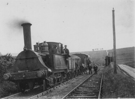
Part of the line opened in 1830 with the remainder following in 1831; Hopton Incline was in the first, southern part. The 33 mile route originally included nine inclined planes, which were often referred to as "planes" rather than "inclines"; staff who worked on inclines, for example, were formally known as "Planemen". Initially, all nine planes were double track. Trains were chain-hauled, eight were powered by a stationary winding engine at the summit, with ascending and descending wagons acting as counterbalances to ease the load. The Whaley Bridge incline was initially horse-drawn. At first trains were horse-drawn between inclines, with steam locomotives starting to appear in 1833, becoming universal by the 1860s except on the Whaley Bridge incline. Inclines were a means to cross hilly terrain, but they imposed significant costs in money and time. [6]

By the 1870s Hopton Incline's winding engine had given 40 years' service and was life-expired. During that time locomotive power had improved, in 1877 Hopton incline's chains and engines were removed, after which the incline became a conventional adhesion railway; trains ascended the bank under their own power and descended using their own brakes. The more westerly line on the incline fell into disuse and was lifted at some time between 1889 and 1903. [7] In 1886 an inspector recommended the gradient be eased to allow greater loads, but nothing happened until 1903 [8] when the trackbed at the foot of the incline was raised to ease the slope, which northbound trains approached at the gently downhill gradient of 1 in 1056. The top was also shaved to ease a short final stretch to 1 in 470. From the bottom the amended slope became progressively steeper in stages: 1 in 60 for 200 yards (180 m), 1 in 30 for 75 yards (69 m), 1 in 20 for 100 yards (91 m), then 200 yards (180 m) at 1 in 14, easing to 1 in 470 before levelling off. [2] [9] The approach was gently downhill, but it included what in railway terms was a fairly sharp bend of 20 chains (400 m) radius, 160 yards (150 m) before the incline foot.

Incline locations

From south to north, Hopton was one of several inclines on the Cromford and High Peak Railway:

InclineLength Gradient Notes
Cromford 580 yards (530 m)1 in 9Combined with Sheep Pasture in 1857, [10] combined name "Sheep Pasture Incline"
Sheep Pasture 711 yards (650 m)1 in 8Combined with Cromford in 1857, [10] combined name "Sheep Pasture Incline"
Middleton 708 yards (647 m)1 in 8½
Hopton457 yards (418 m)1 in 14Chain-hauled until 1877, conventional adhesion thereafter [11] [12]
Hurdlow 850 yards (777 m)1 in 16Bypassed and abandoned 1869 [13]
Bunsall Upper 660 yards (604 m)1 in 17½Combined with Bunsall Lower in 1857, [10] combined name "Bunsall Incline", abandoned 1892
Bunsall Lower 455 yards (416 m)1 in 7Combined with Bunsall Upper in 1857, [10] combined name "Bunsall Incline", abandoned 1892
Shallcross 817 yards (747 m)1 in 10¼Abandoned 1892
Whaley Bridge 180 yards (165 m)1 in 13½Abandoned 1952

Services

Hopton Incline in 1964 Hopton Incline Top.jpg
Hopton Incline in 1964

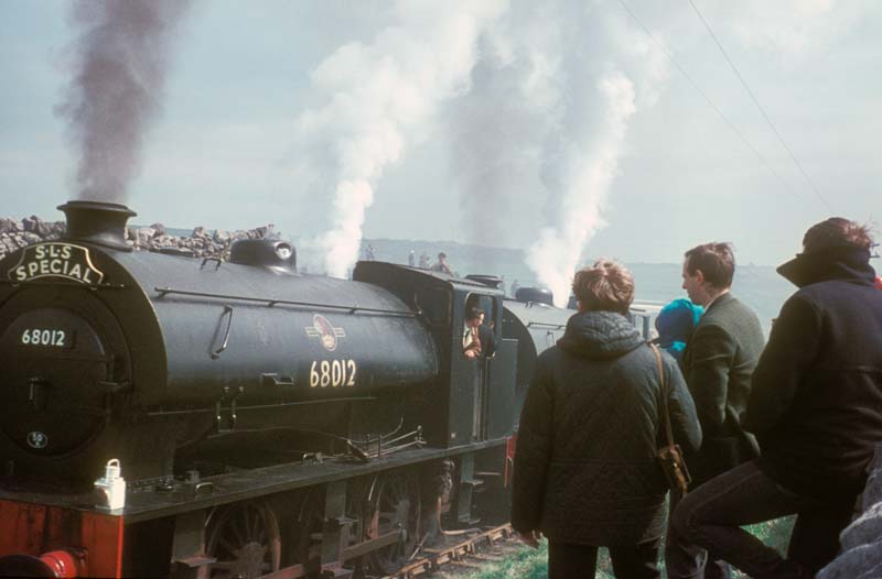
The section of line including the incline was opened on 29 May 1830. [14] Initially, trains to and from the incline were horse-drawn, but the intention, as enshrined in the enabling legislation, was also to use steam locomotives, the first of which started work in 1833. [15] Horse-haulage finished by the mid-1860s. [16] Steam locomotives started to use the incline from 18 April 1877. [1] Diesel shunter 12006 was trialled in 1959, but was considered unsuitable, largely because it was barely able to climb the incline on its own, without any load. [17] [18] [19] A further trial took place in August 1966, using Class 08 diesel shunter D3778. [20] The locomotive was rostered to take over from steam from 31 August 1966, but for some reason it did not happen and steam monopolised the incline until closure the following spring. [21] Trains were conventional, but locomotives and rolling stock nevertheless had to be carefully selected. Only four-wheeled wagons, tenders and brake vans were permitted and few locomotives could negotiate Gotham Curve's extreme curvature without putting machine and track under unacceptable strain. [22] This led to a limited number of locomotive types using the curve for unusually long periods. [23] In 1931 several NLR 0-6-0Ts were moved from the London area to the line, remaining there until 1960, when they were displaced by a small fleet of J94 0-6-0STs, which worked the stretch until closure. Both classes of locomotive, despite having six-coupled wheels, were specifically designed for low-speed, high power dock and shunting work, where they could encounter severe curves and gradients. Not only was short wheelbase rolling stock necessary for the line's tight curves, but Hopton Incline imposed a severe limit as to what load could be hauled uphill, especially in wet or icy moorland conditions, when splitting trains down to two wagons at a time was not rare.

Passenger services ran up and down the incline from 1833 to 1876. [24] The line's rule book made it clear that passengers were not to stay on board on inclines, but this was not always observed. Loadings in this sparsely-populated upland area were very light. [25] [26] Evidence of the forms of provision is patchy and inconsistent, [27] with the clearest sources being anecdotal. [28] [29] [30] [31] Some horse-drawn provision appears to have been based on stage-coaches, with inside and outside provision similar to the 'Dandy' used on the service to Port Carlisle. Later, locomotive-hauled, passengers were accommodated by attaching a specially adapted guard's van to conventional goods trains; the adaptation consisted of putting some seating in the van's goods section. This was known on the line as a "Fly", though the term appears to have been used interchangeably to mean the vehicle and the train. [26]

Passenger traffic was slight and general goods was substantially less than the line's promoters foresaw, [32] especially after the line was effectively bypassed in the 1860s then truncated in 1892. The sparsely populated, largely agricultural area surrounding the curve meant that coal was the only significant inflow and milk the only significant outflow, except for the one traffic which dominated all – stone products, notably limestone and burnt lime. This traffic grew, and kept the line through the incline open despite its many operating obstacles, of which the incline was but one. Towards the end the incline's significance grew, as quarrying processes became more efficient and rail sought higher payloads the light trains of four-wheels-only limitations kept trains short and composed of small, slow-moving, obsolescent and uneconomic wagons. [33] There was one other traffic, a 19th-century relic, whereby the line carried water. Limestone uplands drain naturally, so, despite the high rainfall, water supply to outlying properties was a problem. Some railway properties needed water, the railway itself needed water and in the 1960s Prestwich Intake Quarry needed water, so it was carried on trains using specially adapted former locomotive tenders. [34] [35] [36] [37] [38] [39]

On October 6, 1937, the 8:35 am freight train going from Middleton to Parsley Hay left the rails while running chimney first at the foot of the Hopton Incline. Traveling at a speed of around 45 miles per hour and consisting of four laden wagons and a 20-ton brake van, the engine, three of the wagons, and the brake van were impelled down a 25-foot embankment, coming to rest on a public road. The fourth wagon remained on the embankment, running off on the opposite side of the track. [40]

Closure

By the 1960s, rail services on the line has almost become exclusively block trains from local quarries. These freight services slowly decreased further during the Beeching era. In 1963 the rope-worked 1 in 8 Middleton Incline became the first section of the Cromford and High Peak line to closed. This was then followed by the Middleton Top-Friden section, including the 1 in 8 Sheep Pasture Incline and the Hopton Incline, which closed on 21 April 1967. [41] The final section was between Friden Goods Yard and Hindlow which closed on 2 October 1967. [42]

Preservation

In 1971 the Peak Park Planning Board and Derbyshire County Council bought the track bed from the site of Hurdlow station, near Buxton, through the Hopton Incline to High Peak Junction, near Cromford and turned it into the High Peak Trail, which is now National Route 54 of the National Cycle Network. The trail is popular with walkers, cyclists and horse riders. [43] [44]

The High Peak Trail is also designated as part of the Pennine Bridleway, a leisure route that starts at Middleton Top, not far from the incline, and covers 73 miles (117 km) through Derbyshire to the South Pennines.

The incline was dramatic in railway terms. As part of an off-road trail it catches the public's eye, but not with the same impact as rope-hauled inclines, embankments, machinery, buildings and scenery. The adjacent road also diminishes the impact except for people "in the know". It is, nevertheless, preserved for all to enjoy. [45]

Related Research Articles

<span class="mw-page-title-main">Wye (rail)</span> Y-shaped rail junction

In railroad structures, and rail terminology, a wye or triangular junction is a triangular joining arrangement of three rail lines with a railroad switch at each corner connecting to the incoming lines. A turning wye is a specific case.

<span class="mw-page-title-main">Cromford</span> Village in Derbyshire, England

Cromford is a village and civil parish in Derbyshire, England, in the valley of the River Derwent between Wirksworth and Matlock. It is 17 miles (27 km) north of Derby, 2 miles (3.2 km) south of Matlock and 1 mile (1.6 km) south of Matlock Bath. It is first mentioned in the 11th-century Domesday Book as Crumforde, a berewick of Wirksworth, and this remained the case throughout the Middle Ages. The population at the 2011 Census was 1,433. It is principally known for its historical connection with Richard Arkwright and the nearby Cromford Mill, which he built outside the village in 1771. Cromford is in the Derwent Valley Mills World Heritage Site.

<span class="mw-page-title-main">Cromford and High Peak Railway</span> Early British railway company (1833–1871)

The Cromford and High Peak Railway (C&HPR) was a standard-gauge line between the Cromford Canal wharf at High Peak Junction and the Peak Forest Canal at Whaley Bridge. The railway, which was completed in 1831, was built to carry minerals and goods through the hilly rural terrain of the Peak District within Derbyshire, England. The route was marked by a number of roped worked inclines. Due to falling traffic, the entire railway was closed by 1967.

<span class="mw-page-title-main">High Peak Trail</span> Bridleway in the English Peak District

The High Peak Trail is a 17-mile (27 km) trail for walkers, cyclists and horse riders in the Peak District of England. Running from Dowlow (53.2059°N 1.8349°W), near Buxton, to High Peak Junction, Cromford (53.1004°N 1.5354°W), it follows the trackbed of the former Cromford and High Peak Railway, which was completed in 1831 to carry minerals and goods between the Cromford Canal wharf at High Peak Junction and the Peak Forest Canal at Whaley Bridge.

<span class="mw-page-title-main">Ecclesbourne Valley Railway</span> Heritage railway in England

The Ecclesbourne Valley Railway is a 9-mile (14.5 km) long heritage railway in Derbyshire. The headquarters of the railway centre on Wirksworth station, and services operate in both directions between Wirksworth and Duffield and from Wirksworth to Ravenstor.

<span class="mw-page-title-main">Cromford Canal</span>

The Cromford Canal ran 14.5 miles from Cromford to the Erewash Canal in Derbyshire, England with a branch to Pinxton. Built by William Jessop with the assistance of Benjamin Outram, its alignment included four tunnels and 14 locks.

<span class="mw-page-title-main">Steeple Grange Light Railway</span> Narrow gauage visitor attraction railway

The Steeple Grange Light Railway is a narrow-gauge heritage railway visitor attraction near Wirksworth in Derbyshire, England. Opened in 1985 on the trackbed of a disused branch line, it uses industrial locomotives and rolling stock from disused mines, quarries, and steelworks around the country.

<span class="mw-page-title-main">Cable railway</span> Railway that uses a cable, rope or chain to haul trains

A cable railway is a railway that uses a cable, rope or chain to haul trains. It is a specific type of cable transportation.

<span class="mw-page-title-main">Hopton, Derbyshire</span> Human settlement in England

Hopton is a small village adjacent to the village of Carsington and two miles (3.2 km) from the market town of Wirksworth in the Peak District.

<span class="mw-page-title-main">Bolehill, Derbyshire</span> Human settlement in England

Bolehill is an area of Wirksworth, Derbyshire, England. It is located in the north of the town and has connections to the lead mining. Bolehill is adjacent to Black Rocks, a local landmark and a short walk from the High Peak Trail at Middleton incline.

<span class="mw-page-title-main">Middleton-by-Wirksworth</span> Village and civil parish in Derbyshire Dales, Derbyshire, England

Middleton or Middleton-by-Wirksworth is an upland village and civil parish lying approximately one mile NNW of Wirksworth, Derbyshire, England. Middleton was, in 1086, a berewick of the town and manor of Wirksworth. Middleton was formerly known for its lead mines and high quality limestone quarries, including the underground quarry site at Middleton Mine. The Middleton Mine networks underground for approximately 25 miles (40 km) with tunnels on three different levels running under Middleton Moor to the Hopton Wood quarry works at the other side of the hill below Ryder Point Works’. Part of the tunnel collapsed in the 1970s leaving a noticeable depression in the ground above on the eastern side of Middleton Moor. The population of the parish as taken at the 2011 Census was 775.

<span class="mw-page-title-main">High Peak Junction</span>

High Peak Junction, near Cromford, Derbyshire, England, is the name now used to describe the site where the former Cromford and High Peak Railway (C&HPR), whose workshops were located here, meets the Cromford Canal. It lies within Derwent Valley Mills World Heritage Site, designated in 2001, and today marks the southern end of the High Peak Trail, a 17 miles (27 km) trail for walkers, cyclists and horse riders. The Derwent Valley Heritage Way also passes this point, and popular walks lead from here along the towpath in both directions.

<span class="mw-page-title-main">LNWR DX Goods class</span>

The London and North Western Railway (LNWR) DX Goods class was a class of 0-6-0 steam locomotive, designed by John Ramsbottom for freight duties. 943 were constructed, making them the largest single class of steam locomotives built in the United Kingdom. Despite this, none were preserved.

<span class="mw-page-title-main">Gotham Curve</span>

The Gotham Curve was once the sharpest curve on any standard gauge railway line in the UK. The curve, which was situated in the sparsely populated, exposed limestone uplands in the Peak District of Derbyshire, England, was on the Cromford and High Peak Railway. The single-track main line was inherited by British Railways in 1948. It closed in 1967.

Cromford Incline is a former railway incline in Cromford, Derbyshire. Historically on the Cromford and High Peak Railway. The incline was one of six inclines along the entire line from Cromford to Whaley Bridge in High Peak, Derbyshire. The incline was opened in 1830 and was in use until 1967 when the entire line from Whaley Bridge to Middleton was closed. With the section to Cromford closing in 1963. Today, the incline is used as part of the High Peak Trail. Cromford Incline was also 1 in 9 gradient. Like the other ones along the former railway.

Sheep Pasture Incline is a former railway incline in Sheep Pasture, Derbyshire. Historically on the Cromford and High Peak Railway. The incline was one of six inclines along the entire line from Cromford to Whaley Bridge in High Peak, Derbyshire. The incline was opened in 1830 and was in use until 1967 when the entire line from Whaley Bridge to Middleton was closed. With the section to Cromford closing in 1963. Today, the incline is used as part of the High Peak Trail. Sheep Pasture Incline was also 1 in 9 gradient, like the other ones along the former railway.

Steeplehouse and Wirksworth Goods Yard was a goods station located on the Cromford and High Peak Railway in Wirksworth, Derbyshire. It consisted of three sidings and a few goods sheds. Mostly for moving mineral and quarry traffic. It closed in 1967 along with the rest of the line. And today, nothing remains of the goods yard. Today, a section of the former line is used by the Steeplehouse Grange Light Railway.

<span class="mw-page-title-main">Steeple House railway station</span> Former railway station in Derbyshire, England

Steeple House railway station was a minor station on the Cromford and High Peak Railway on the outskirts of Wirksworth, Derbyshire. The station opened in 1855 to passengers but was closed in 1876. There were several sidings around the station serving limestone quarries. The line remained in use until 21 April 1967, when it closed to all mineral traffic. Today, the Steeplehouse Grange Light Railway is located east of the former site. The National Stone Centre is also located nearby to the site. Only the trackbed remains as the High Peak Trail.

Middleton Incline is a former railway incline in Middleton, Derbyshire. Historically on the Cromford and High Peak Railway. The incline was one of six inclines along the entire line from Cromford to Whaley Bridge in High Peak, Derbyshire. The incline was opened in 1830 and was in use until 1967 when the entire line from Whaley Bridge to Middleton was closed. With the section to Cromford closing in 1963. Today, the incline is used as part of the High Peak Trail. Middleton Pasture Incline was also 1 in 9 gradient. Like the other ones along the former railway.

Friden Goods Yard railway station was a minor railway station located on the Cromford and High Peak Railway near the village of Friden in Derbyshire. Located on a line mostly used for mineral and quarry traffic. It opened to passengers in 1855 and closed in 1876 due to relatively but not uncommon low usage. The goods station then closed in 1967 along with the rest of the line. And today, nothing remains of the goods yard or the passenger station. The trackbed now forms part of the High Peak Trail.

References

  1. 1 2 Rimmer 1998, p. 58.
  2. 1 2 Coleford 1996a, p. 10.
  3. Jones & Bentley 2001, pp. 20–21.
  4. Marshall 2011, p. 58.
  5. "The incline on a 25" Edwardian OS map, with modern overlays". National Library of Scotland.
  6. Penalties of inclined planes, Locomotive Magazine, issue 491, 15 July 1933 pp.206-8 Steam Index
  7. Marshall 2011, p. 42.
  8. Rimmer 1998, pp. 58 & 69.
  9. Marshall 2011, pp. 43–45.
  10. 1 2 3 4 Marshall 2011, p. 28.
  11. Jones & Bentley 2001, p. 17.
  12. Rimmer 1998, p. 14.
  13. Marshall 2011, p. 57.
  14. Rimmer 1998, p. 9.
  15. Rimmer 1998, pp. 7 & 12.
  16. Marshall 2011, p. 38.
  17. Coleford 1996a, p. 20.
  18. Coleford 1996b, p. 297.
  19. Miles 2013c, p. 359.
  20. Cooke 1966, p. 640.
  21. Coleford 1996a, p. 21.
  22. Coleford 1996a, p. 11.
  23. Jones & Bentley 2000, p. 36.
  24. Marshall 2011, p. 59.
  25. Moorsom and the Attempt to Revive the Cromford And High Peak Railway Derbyshire Archaeological Journal 1983 see Appendix 1
  26. 1 2 Marshall 2011, p. 56.
  27. Quick 2009, pp. 433–4.
  28. Marshall 2011, pp. 53–55.
  29. A journey on the line in 1837 Manchester City News
  30. A journey on the line in 1854 Derby Mercury
  31. A journey on the line in 1883: Williams, Chap IV, p. 99 Google Books
  32. Marshall 2011, p. 21.
  33. Coleford 1996a, p. 28.
  34. Coleford 1996a, p. 26.
  35. Jones & Bentley 2001, pp. 15, 31, 35, 39 & 43–48.
  36. Rhodes 1967, p. 98.
  37. Marshall 2011, pp. 33, 47, 76 & 85.
  38. Rimmer 1998, pp. 24 & 84.
  39. Broome 1985, pp. 23, 24, 44 & 56.
  40. "Report on the Accident at Hopton Incline on 6th October 1937 :: The Railways Archive".
  41. "Cromford closure". Modern Railways (July 1967 ed.). p. 398.
  42. "Parsley Hay Station". disused-stations.org.uk. Retrieved 20 February 2023.
  43. The High Peak Trail Sustrans
  44. The High Peak Trail Derbyshire Peak District
  45. Attractions on the High Peak Trail Derbyshire County Council

Sources

53°05′18″N1°37′19″W / 53.0883697°N 1.6219715°W / 53.0883697; -1.6219715