The Peak District is an upland area in England, at the southern end of the Pennines. Mostly in Derbyshire, it extends into Cheshire, Greater Manchester, Staffordshire, West Yorkshire and South Yorkshire and includes the Dark Peak, moorland dominated by gritstone, and the White Peak, a limestone area with valleys and gorges. The Dark Peak forms an arc on the north, east and west sides; the White Peak covers central and southern tracts. The Peak District was the first of the national parks of England and Wales in 1951. The historic Peak District extends beyond the National Park, which excludes major towns, quarries and industrial areas. Nearby Manchester, Stoke-on-Trent, Derby and Sheffield send millions of visitors. Inhabited from the Mesolithic era, it shows evidence of the Neolithic, Bronze and Iron Ages. Settled by the Romans and Anglo-Saxons, it remained largely agricultural; mining arose in the Middle Ages. Richard Arkwright built cotton mills in the Industrial Revolution. As mining declined, quarrying grew. Tourism came with the railways, spurred by the landscape, spa towns and Castleton's show caves.

The Derwent is a river in Derbyshire, England. It is 50 miles (80 km) long and is a tributary of the River Trent, which it joins south of Derby. Throughout its course, the river mostly flows through the Peak District and its foothills.

The River Etherow is a river in northern England, and a tributary of the River Goyt. Although now passing through South Yorkshire, Derbyshire and Greater Manchester, it historically formed the ancient county boundary between Cheshire and Derbyshire. The upper valley is known as Longdendale. The river has a watershed of approximately 30 square miles (78 km2), and the area an annual rainfall of 52.5 inches (1,330 mm).

The River Goyt is a tributary of the River Mersey in North West England.

The Upper Goyt Valley is the southern section of the valley of the River Goyt in North West England.
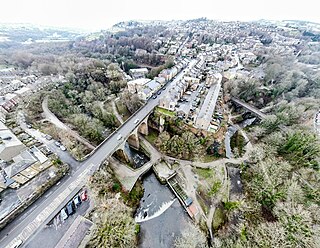
New Mills is a town in the Borough of High Peak, Derbyshire, England, 8 miles (13 km) south-east of Stockport and 13 miles (21 km) from Manchester at the confluence of the River Goyt and Sett. It is close to the border with Cheshire and above the Torrs, a 70 feet (21 m) deep gorge cut through carboniferous sandstone, on the north-western edge of the Peak District national park.

Whaley Bridge is a town and civil parish in the High Peak district of Derbyshire, England. It is situated on the River Goyt, 16 miles (26 km) south-east of Manchester, 7 miles (11 km) north of Buxton, 9 miles (14 km) north-east of Macclesfield and 28 miles (45 km) west of Sheffield. It had a population of 6,455 at the 2011 census, including Furness Vale, Horwich End, Bridgemont, Fernilee, Stoneheads and Taxal.

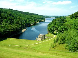
Cromford is a village and civil parish in Derbyshire, England, in the valley of the River Derwent between Wirksworth and Matlock. It is 17 miles (27 km) north of Derby, 2 miles (3.2 km) south of Matlock and 1 mile (1.6 km) south of Matlock Bath. It is first mentioned in the 11th-century Domesday Book as Crumforde, a berewick of Wirksworth, and this remained the case throughout the Middle Ages. The population at the 2011 Census was 1,433. It is principally known for its historical connection with Richard Arkwright and the nearby Cromford Mill, which he built outside the village in 1771. Cromford is in the Derwent Valley Mills World Heritage Site.
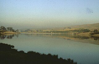
Errwood Reservoir is a drinking-water reservoir in the Peak District National Park, within the county of Derbyshire and very close to the boundary with Cheshire. The reservoir was the second of two reservoirs built in the Goyt Valley, the other one being Fernilee Reservoir. It was constructed by the Stockport Water Corporation at a cost of £1.5 million, with work being completed in 1967; it is currently owned and operated by United Utilities. The reservoir provides drinking water for the town of Stockport and its surrounding areas, and it holds 4,215 million litres (1.113×10⁹ US gal) of water.

The Buxton line is a railway line in Northern England, connecting Manchester with Buxton in Derbyshire. Passenger services on the line are currently operated by Northern Trains.

The River Kinder is a small river, only about 3 miles (4.8 km) long, in northwestern Derbyshire, England. Rising on the peat moorland plateau of Kinder Scout, it flows generally westwards to its confluence with the River Sett at Bowden Bridge. En route it flows through the Kinder Gates rocks, over the waterfall known as Kinder Downfall, and through Kinder Reservoir, built in 1903–12 by the Stockport Corporation Water Works. Until the 19th century at least, the name was formerly also applied to the River Sett as far as its confluence with the River Goyt in New Mills.
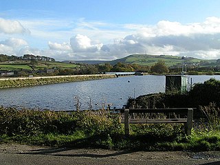
Toddbrook Reservoir, a feeder for the Peak Forest Canal, opened in 1838. It is sited above the town of Whaley Bridge in the Derbyshire High Peak area of England. The reservoir is a Site of Special Scientific Interest (SSSI) providing habitats for herons, ducks and other animals and fish, while rare mosses and liverworts grow on its shores, particularly short-lived species that grow on seasonally exposed mud. The reservoir is used for sailing and angling. The Peak District Boundary Walk runs around the eastern end of the reservoir. The reservoir is owned by the Canal & River Trust and, like the nearby Combs Reservoir, is a feeder reservoir for the Peak Forest Canal. The feeder runs through Whaley Bridge, and with the Combs feed enters the canal system in a pool close to the transhipment shed at the Whaley Bridge canal basin.

The ruin of Errwood Hall is a popular tourist destination in the scenic Upper Goyt Valley within the Peak District of England.
Thornsett is a hamlet within the civil parish of New Mills in Derbyshire. It lies between New Mills and Hayfield, and features a primary school, a nursery, two pubs, a band room and a cemetery. It is roughly 13 miles (21 km) southeast of central Manchester and 22 miles (35 km) west of Sheffield. The hamlet is governed by High Peak Borough Council and, as it lies within New Mills' parish boundaries, New Mills Town Council.
Shallcross is a small village in northwestern Derbyshire, England. It is located 15 miles (24 km) south of Manchester, at the edge of the Peak District, on the eastern side of the River Goyt. Located between Whaley Bridge and Fernilee, it is now administered as part of the larger community of Whaley Bridge. The area attracts many outdoors enthusiasts, especially hikers, because of the beauty and variety of the scenery. The country rises steeply as it ascends the Goyt Valley from the canal terminal at Whaley Bridge, past the Fernilee Reservoir, and onto the highlands of Axe Edge Moor.

Mellor Mill, also known as Bottom's Mill, was a six-story cotton mill in Marple, Greater Manchester built by Samuel Oldknow in 1793. This was a six-storey, 42-foot (13 m) wide and 210-foot (64 m) long mill with additional three-storey wings making it 400 feet (120 m) in all. The mill was built for Samuel Oldknow and used to spin coarse counts. It was originally driven by the Wellington water wheel. The River Goyt, and with it the then county boundary between Derbyshire and Cheshire was diverted and a weir built, the leat fed a millpond that in later times was named the Roman Lakes. This in turn fed a second mill pond along with water from reservoir in Linnet Clough. Supplementary power was provided by a second exterior wheel known as the Waterloo wheel. The Mill reached its peak production in 1804, when 10,080 spindles were operating and around 550 people were employed. It was destroyed by fire in 1892.

The Goyt Way is a 10-mile (16 km) walking route from Etherow Country Park, Greater Manchester, to Whaley Bridge, Derbyshire, following the valley of the River Goyt. It is part of the longer Midshires Way, which in turn is part of the E2 European long-distance path. The path is waymarked, and intersects with the Cheshire Ring Canal Walk and the Peak District Boundary Walk. It passes through the following settlements: Compstall, Marple, Strines, Brookbottom, Hague Bar, New Mills and Furness Vale. In its latter stages, it follows the towpath of the Peak Forest Canal to its terminus at Whaley Bridge.
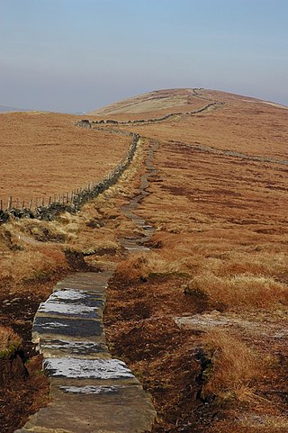
The Peak District Boundary Walk is a circular 190-mile (310 km) walking trail, starting and finishing at Buxton and broadly following the boundary of the Peak District, Britain's first national park. The route was developed by the Friends of the Peak District and was launched on 17 June 2017.

Burbage Edge is a gritstone escarpment overlooking the Burbage district of Buxton in Derbyshire, in the Peak District. The hill's summit is 500 metres (1,600 ft) above sea level.
Cats Tor is a Peak District hill on the border between Cheshire and Derbyshire, between the towns of Macclesfield and Buxton. The summit is 518 metres (1,699 ft) above sea level. Tor is an Old English word for a high, rocky hill.