Related Research Articles

The Cromford and High Peak Railway (C&HPR) was a standard-gauge line between the Cromford Canal wharf at High Peak Junction and the Peak Forest Canal at Whaley Bridge. The railway, which was completed in 1831, was built to carry minerals and goods through the hilly rural terrain of the Peak District within Derbyshire, England. The route was marked by a number of roped worked inclines. Due to falling traffic, the entire railway was closed by 1967.

Parsley Hay railway station served Parsley Hay, a hamlet within Hartington Middle Quarter civil parish, about 9.3 miles (15 km) south east of Buxton, Derbyshire, on the LNWR line to Ashbourne. The nearest large settlement is the village of Hartington.

Higher Buxton railway station was opened in 1894 to the south east of Buxton, Derbyshire, on the LNWR line to Ashbourne and the south.
Shallcross is a small village in northwestern Derbyshire, England. It is located 15 miles (24 km) south of Manchester, at the edge of the Peak District, on the eastern side of the River Goyt. Located between Whaley Bridge and Fernilee, it is now administered as part of the larger community of Whaley Bridge. The area attracts many outdoors enthusiasts, especially hikers, because of the beauty and variety of the scenery. The country rises steeply as it ascends the Goyt Valley from the canal terminal at Whaley Bridge, past the Fernilee Reservoir, and onto the highlands of Axe Edge Moor.
RAF Harpur Hill was a Royal Air Force base, situated at Harpur Hill near Buxton, Derbyshire in England. The site was operational from 1938 to 1960 and was mainly used as an underground munitions storage facility. It became the largest ammunitions dump in the country across the 500 acres (200 ha) site.

Chinley, Buxworth and Brownside is a civil parish within the High Peak district, which is in the county of Derbyshire, England. Partially rural with several villages contained within, its population was 2,796 residents in the 2011 census. The parish is 150 miles (240 km) north west of London, 35 miles (56 km) north west of the county city of Derby, and 1+1⁄3 miles (2.1 km) north of the nearest market town of Chapel-en-le-Frith. Being on the edge of the county border, it shares a boundary with the parishes of Chapel-en-le-Frith, Edale, Hayfield, New Mills and Whaley Bridge. A substantial portion of the parish is within the Peak District national park.
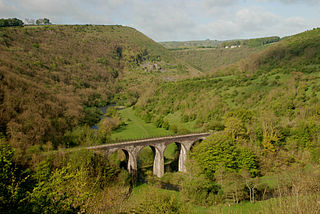
The White Peak Loop is a 60-mile (97 km) route for walking, cycling and horse riding in the Peak District of England. The trail combines sections of the High Peak Trail and the Monsal Trail with linking sections through the towns of Buxton, Bakewell and Matlock. The White Peak Loop is being developed by Derbyshire County Council and as of 2022 some sections are not yet complete.
Cromford Incline is a former railway incline in Cromford, Derbyshire. Historically on the Cromford and High Peak Railway. The incline was one of six inclines along the entire line from Cromford to Whaley Bridge in High Peak, Derbyshire. The incline was opened in 1830 and was in use until 1967 when the entire line from Whaley Bridge to Middleton was closed. With the section to Cromford closing in 1963. Today, the incline is used as part of the High Peak Trail. Cromford Incline was also 1 in 9 gradient. Like the other ones along the former railway.
Steeplehouse and Wirksworth Goods Yard was a goods station located on the Cromford and High Peak Railway in Wirksworth, Derbyshire. It consisted of three sidings and a few goods sheds. Mostly for moving mineral and quarry traffic. It closed in 1967 along with the rest of the line. And today, nothing remains of the goods yard. Today, a section of the former line is used by the Steeplehouse Grange Light Railway.
Steeple House railway station was a minor station on the Cromford and High Peak Railway on the outskirts of Wirksworth, Derbyshire. The station opened in 1855 to passengers but was closed in 1876. The line remained in use until 1967 when it closed to all mineral traffic. Today, the Steeplehouse Grange Light Railway is located east of the former site. The National Stone Centre is also located nearby to the site. Only the trackbed remains as the High Peak Trail.
Longcliffe Goods Yard was a goods station located on the Cromford and High Peak Railway in Longcliffe, Derbyshire. Mostly for moving mineral and quarry traffic. It closed in 1967 along with the rest of the line. And today, nothing remains of the goods yard. The trackbed now forms part of the High Peak Trail.
Minninglow Goods Yard was a goods station located on the Cromford and High Peak Railway near the villages of Aldwark, Pikehall and Longcliffe in Derbyshire. Mostly for moving mineral and quarry traffic. It closed in 1967 along with the rest of the line. And today, nothing remains of the goods yard. The trackbed now forms part of the High Peak Trail. The site of Minninglow is also now a landmark on the High Peak Trail.
Friden Goods Yard was a goods station located on the Cromford and High Peak Railway near the villages of Friden in Derbyshire. Mostly for moving mineral and quarry traffic. It closed in 1967 along with the rest of the line. And today, nothing remains of the goods yard. The trackbed now forms part of the High Peak Trail.
Friden Goods Yard railway station was a minor railway station located on the Cromford and High Peak Railway near the village of Friden in Derbyshire. Located on a line mostly used for mineral and quarry traffic. It opened to passengers in 1855 and closed in 1876 due to relatively but not uncommon low usage. The goods station then closed in 1967 along with the rest of the line. And today, nothing remains of the goods yard or the passenger station. The trackbed now forms part of the High Peak Trail.
Middleton railway station was a minor railway station on the Cromford and High Peak Railway on the Middleton Incline. Outside of Middleton, Derbyshire. Opened in 1855 and closed in 1876. Nothing remains of the former station.
Hopton Top Wharf railway station was a minor railway station on the Cromford and High Peak Railway near the Hopton, Derbyshire. Opened in 1855 and closed in 1876. Nothing remains of the former station.
Longcliffe railway station was a minor railway station on the Cromford and High Peak Railway. Near Longcliffe, Derbyshire. Opened in 1855 and closed in 1876. Nothing remains of the former station.
Ladmanlow railway station was a minor railway station located on the Cromford and High Peak Railway near Buxton in Derbyshire. Located on a line mostly used for mineral and quarry traffic. It opened to passengers in 1855 and closed in 1876 due to relatively but not uncommonly low usage. The goods station then closed in 1967 along with the rest of the line. Today, nothing remains of the station. It was also the terminus of the line originally for passengers until 1874 when it was extended to Buxton/Whaley Bridge. The trackbed now forms part of the A54 Road.
Bunsail railway station was a minor railway station located on the Cromford and High Peak Railway near Buxton in Derbyshire. Located on a line mostly used for mineral and quarry traffic. It opened to passengers in 1855 and closed in 1876 due to relatively but not uncommon low usage. The goods station then closed in 1967 along with the rest of the line. And today, nothing remains of the station. The trackbed and tunnel are still traceable on maps but have returned to mostly agriculture and minor roads.
Hartington Middle Quarter is a civil parish within the Derbyshire Dales district, which is in the county of Derbyshire, England. Formerly a part of Hartington parish, for which it is named, it has a mix of a number of villages and hamlets amongst a mainly rural and undulating landscape, and is wholly within the Peak District National Park. It had a population of 379 residents in 2011. The parish is 130 miles (210 km) north west of London, 20 miles (32 km) north west of the county city of Derby, and 5 miles (8.0 km) south east of the nearest market town of Buxton. Being on the edge of the county border, it shares a boundary with the parishes of Chelmorton, Flagg, Hartington Town Quarter, Hartington Upper Quarter, Middleton and Smerrill, Monyash in Derbyshire, as well as Hollinsclough, Longnor and Sheen in Staffordshire.
References
- ↑ https://rchs.org.uk/wp-content/uploads/2018/02/Cromford-High-Peak-Railway-Nov-2001.pdf [ bare URL PDF ]
- ↑ "MDR9136 - Loading wharf, Friden Goods Yard, Hartington Nether Quarter - Derbyshire Historic Environment Record". her.derbyshire.gov.uk.
- ↑ "87721 - GOODS STATION - Derbyshire Historic Environment Record". her.derbyshire.gov.uk.
- ↑ "Disused Stations: Parsley Hay Station". www.disused-stations.org.uk.
| | This article on a railway station in the East Midlands is a stub. You can help Wikipedia by expanding it. |