Magpie Mine

Last updated
Magpie Mine
Magpie Lead Mine near Sheldon.jpg
Lead mine remains
Location Sheldon near Bakewell
Region Derbyshire, England
Coordinates 53°12′42″N1°44′32″W / 53.21167°N 1.74222°W / 53.21167; -1.74222 Coordinates: 53°12′42″N1°44′32″W / 53.21167°N 1.74222°W / 53.21167; -1.74222
Altitude310 m (1,017 ft)
TypeMine
History
Periods17th century
Site notes
ConditionStanding building remains
Public accessFootpath
Website https://pdmhs.co.uk/magpie-mine-peak-district/
Official nameMagpie, Dirty Red Soil, Maypit, Horsesteps and Great Red Soil lead mines
Designated15 January 1974
Reference no.1019490

Aerial view of Magpie Mine Magpie Lead Mine, Sheldon - geograph.org.uk - 639364.jpg
Aerial view of Magpie Mine

Magpie Mine is a well-preserved disused lead mine near the village of Sheldon in Derbyshire, England, in the parish of Ashford in the Water. The walled enclosure of five lead mines (Magpie Mine, Dirty Red Soil, Great Red Soil, Maypit and Horsesteps) is a protected Scheduled Monument. [1]

Mid-Derbyshire has a history of industrial lead mining going back to Roman times. Lead mining at this site goes back to at least the 17th century. The Shuttlebark vein of lead ore was officially opened in 1682. Magpie Mine is recorded back to 1740. After over 200 years of operation, Magpie Mine closed in 1958 and was the last working lead mine in Derbyshire. The Peak District Mines Historical Society now manages the site and has undertaken much restoration work. [1] [2]

Headgear of the main shaft Magpie Mine 2.jpg
Headgear of the main shaft

Between productive, profitable times, there were closures for several years in 1793 and in 1835 because of floods, disputes and drops in the price of lead. In 1833 a bitter dispute led to three miners from the neighbouring Maypitt Mine being suffocated by smoke from fires lit deliberately by miners from the Magpie Mine. A murder trial followed but all of the 24 suspected culprits were freed because they had been provoked and it was also unclear which of them was actually responsible. [3]

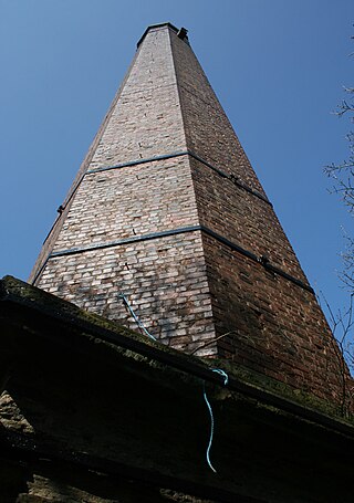
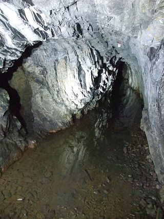
The renowned mining engineer John Taylor took over management of the mine in 1839 and he established a complex of new limestone buildings and innovative equipment. The square chimney (renovated in 2016) and the circular chimney were both built in 1840. The agent's house, smithy, winding house (now demolished), circular gunpowder house and engine reservoir (to supply boiler and cooling water to the engines) were all constructed in the 1840s. In 1869 the Cornish engine house replaced an earlier engine house building and the winding engine was installed, with the winding drum that still remains. The main shaft was sunk in 1823 and is over 200m deep. The underground channel used to drain floodwater from the mines (the sough) was built from 1873 to 1881 and runs about 2 kilometres (1.2 mi) to its outlet into the River Wye to the north (carrying several million litres of water per day). The mine closed with financial troubles in 1883. It was operating for brief spells between 1913 and 1923 but was then only reopened again in 1950, before finally closing down in 1958. The existing steelwork frame of the headgear above the main shaft and the corrugated iron winding house are from the 1950s. The underground mine shafts are now all closed for safety. [1]

A reproduction horse gin has been set up at the Red Soil mine shaft, where the original horse-powered winding gear was used to lift lead ore up to the surface. [2]

There is visitor access to the site along footpaths from Sheldon (about 500m north) and from lanes to the west, south and east. [4]

See also

Related Research Articles

Derbyshire lead mining history History of lead mining in Derbyshire

This article details some of the history of lead mining in Derbyshire, England.

Lathkill Dale Valley in the Derbyshire Peak District

Lathkill Dale is the valley of the River Lathkill near Bakewell, Derbyshire in the Peak District of England. The river emerges into the dale from springs below Lathkill Head Cave. Towards the head of the dale is the side valley Cales Dale.

Great Hucklow Human settlement in England

Great Hucklow is a small village and civil parish in the Derbyshire Peak District which nestles under Hucklow Edge between the villages of Tideswell and Bradwell. It has a population of about 100, including Foolow, Grindlow plus Little Hucklow and being measured at 427 in the 2011 Census. The area is now mainly agricultural, but the village was formerly a centre of the Derbyshire lead mining industry. The lead vein or rake outcrops to the surface to the west of the village and dives under the rocks of Hucklow Edge on the western side of the village where an adit, known as Milldam Mine, has recently been reopened by Glebe Mines Ltd that connects the various deep mines that had formerly been dug along the edge. This mine is being worked for fluorspar, which is frequently found associated with lead in the vein.

National Coal Mining Museum for England

The National Coal Mining Museum for England is based at the site of Caphouse Colliery in Overton, Wakefield, West Yorkshire, England. It opened in 1988 as the Yorkshire Mining Museum and was granted national status in 1995.

Ashford-in-the-Water Human settlement in England

Ashford-in-the-Water is a village and civil parish in the Derbyshire Peak District, England. The village is on the River Wye, 2 miles (3 km) north-west of Bakewell. It is known for the quarrying of Ashford Black Marble, and for the maidens' garlands made to mark the deaths of virgins in the village until 1801. Some of these are preserved in the parish church. The civil parish population taken at the 2011 Census was 559.

Caphouse Colliery

Caphouse Colliery, originally known as Overton Colliery, was a coal mine in Overton, near Wakefield, West Yorkshire, England. It was situated on the Denby Grange estate owned by the Lister Kaye family, and was worked from the 18th century until 1985. It reopened as the Yorkshire Mining Museum in 1988, and is now the National Coal Mining Museum for England.

Levant Mine and Beam Engine

Levant Mine and Beam Engine is a National Trust property at Trewellard, Pendeen, near St Just, Cornwall, England, UK. Its main attraction is that it has the world's only Cornish beam engine still operated by steam on its original site. There is also a visitor centre, a short underground tour, and the South West Coast Path leads to Botallack Mine, via a cliff-top footpath.

Gwennap Human settlement in England

Gwennap is a village and civil parish in Cornwall, England. It is about five miles (8 km) southeast of Redruth. Hamlets of Burncoose, Comford, Coombe, Crofthandy, Cusgarne, Fernsplatt, Frogpool, Goon Gumpas Hick's Mill, Tresamble and United Downs lie in the parish, as does Little Beside country house.

Odin Mine Disused lead mine in Derbyshire, England

Odin Mine is a disused lead mine in the Peak District National Park, situated at grid reference SK133835. It lies on a site of 25 hectares near the village of Castleton, England. It is the oldest documented mine in Derbyshire and is thought to be one of the oldest lead mines in England. The mine is a Scheduled Ancient Monument and has biological and geological significance within the Castleton Site of Special Scientific Interest.

Sheldon, Derbyshire Human settlement in England

Sheldon is a village in the Derbyshire Peak District, England near Bakewell. It is best known for being the closest village to Magpie Mine, a lead mine with an engine house built in the Cornish style. Lead mining flourished around here in the 18th and 19th centuries. It is now scheduled as an ancient monument, and is the most complete example of a lead mine remaining in the Peak District. It is about 1050 feet above sea level. Sheldon is home of the Church of St Michael and All Angels as well. The church was erected in the 19th century with material derived from dismantling the former Chapel of Ease.

Foolow Human settlement in England

Foolow is a village in the Derbyshire Peak District.

East Wheal Rose Former metalliferous mine in Cornwall, England

East Wheal Rose was a metalliferous mine around three-quarters of a mile (1.2 km) south east of the village of St Newlyn East and is around 4 miles (6.4 km) from Newquay on the north Cornwall coast, United Kingdom. The country rock at the mine was killas and its main produce was lead ore (galena), but as is usual when mining this mineral, commercial quantities of silver and zinc were also found and sold.

East Pool mine Former metalliferous mine in Cornwall, England

East Pool mine, was a metalliferous mine in the Camborne and Redruth mining area, just east of the village of Pool in Cornwall, England. Worked from the early 18th century until 1945, first for copper and later tin, it was very profitable for much of its life. Today the site has two preserved beam engines and is part of the Cornwall and West Devon Mining Landscape World Heritage Site. It is owned by the National Trust.

Snailbeach Countryside Site

Snailbeach Countryside Site is an industrial archeology site in Shropshire. It is located three 3 miles (4.8 km) south of the village of Pontesbury and around 12 miles (19 km) from the county town of Shrewsbury. At peak of production during the 19th century, it was reputed to be extracting the largest volume of lead per acre in Europe.

Greenside Mine

Greenside Mine was a successful lead mine in the Lake District of England. Between 1825 and 1961 the mine produced 156,000 long tons of lead and 1,600,000 ounces of silver, from around 2 million tons of ore. During the 1940s it was the largest producer of lead ore in the UK. Unusually for a 19th-century metalliferous mine in Britain there are very full records of its activities, dating back to 1825.

Vulcan Mine

Vulcan Mine is a heritage-listed former mine at Mareeba Mining District, Irvinebank, Shire of Mareeba, Queensland, Australia. It was built from c. 1889 to 1930s. It was added to the Queensland Heritage Register on 21 October 1992.

Mount Isa Mine Early Infrastructure

Mount Isa Mine Early Infrastructure is a heritage-listed group of mining infrastructure on the Mount Isa Mine Lease, Mount Isa (locality), City of Mount Isa, Queensland, Australia. They comprise the Lawlor Shaft & Winding Plant, the Urquhart Shaft and Headframe, the Mount Isa Mine Experimental Dam, and the Mount Isa Mine Power Station. They were built from 1924 to c. 1963. They were added to the Queensland Heritage Register on 25 February 2005.

Ravenswood Mining Landscape and Chinese Settlement Area

Ravenswood Mining Landscape and Chinese Settlement Area is a heritage-listed former mining town and archaeological site on the reserve bounded by School Street, Cemetery Road, Railway Street and Burdekin Falls Dam Road, Ravenswood, Charters Towers Region, Queensland, Australia. It was added to the Queensland Heritage Register on 14 October 2016.

Derbyshire Dome Geological formation of the Derbyshire Peak District

The Derbyshire Dome is a geological formation across mid-Derbyshire in England.

Old Millclose Mine

Old Millclose Mine was a lead mine near Wensley, in Derbyshire, England. The engine house of the mine survives as a ruin; it is a scheduled monument.

References

  1. 1 2 3 Historic England. "Magpie, Dirty Red Soil, Maypit, Horsesteps and Great Red Soil lead mines (1019490)". National Heritage List for England . Retrieved 12 April 2020.
  2. 1 2 "Magpie Mine - Peak District places to visit". Peak District Mines Historical Society. Retrieved 12 April 2020.
  3. "Magpie Mine History". Peak District Mines Historical Society. Retrieved 12 April 2020.
  4. OL24 White Peak area (West sheet) (Map). 1:25000. Explorer. Ordnance Survey.