Downtown Calgary

Last updated
Downtown Calgary
Neighbourhood
Downtown Calgary 2020-2.jpg
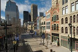
Downtown Calgary seen from the north
Calgary street map.png
Red pog.svg
Location of Downtown Commercial Core in Calgary
Coordinates: 51°02′53″N114°04′17″W / 51.04806°N 114.07139°W / 51.04806; -114.07139
CountryFlag of Canada (Pantone).svg  Canada
Province Flag of Alberta.svg  Alberta
City Flag placeholder.svg  Calgary
QuadrantSW & SE
Wards 7, 8
Established1875
Government
[1]
  Mayor Jyoti Gondek
  Administrative body Calgary City Council
  CouncillorsTerry Wong
Courtney Walcott
Area
[2]
  Total6.0 km2 (2.3 sq mi)
Elevation
1,045 m (3,428 ft)
Population
 (2016) [3]
  Total38,663
  Density6,400/km2 (17,000/sq mi)
   Average Income
$30,126
Website Calgary Downtown

Downtown Calgary is a dense urban district in central Calgary, Alberta. It contains the second largest concentration of head offices in Canada, despite only being the country's fourth largest city in terms of population. [4] The downtown is divided into several residential, commercial, corporate, and mixed-use neighbourhoods, including the Financial District (CBD), Eau Claire, Chinatown, East Village, Beltline, and the West End. [5]

Contents

Downtown Calgary is bordered by 14th Street W. on the west, the Bow River and Prince's Island Park on the north, the Elbow River on the east and the CPR mainline tracks on the south. The neighbourhoods of the Beltline and Mission to the immediate south are often considered part of downtown, due to the high concentrations of businesses, high population densities, and occurrence of retail and nightlife opportunities, but strictly speaking they are not technically part of downtown.

The population of Calgary's downtown has grown substantially in recent years, growing by several thousand between 2011 and 2016. [6] With the population of the five combined downtown neighbourhoods surpassing 18,000 as of 2016, [7] Downtown Calgary now has a significantly larger population than that of other Canadian cities of similar size, such as Ottawa and Edmonton. [8] [9] While downtown Calgary continues to grow, the Beltline neighbourhood to the immediate south, with a population of 21,958 as of 2016, is taking up the majority of residential development in inner city Calgary. [10]

Calgary Transit's CTrain light rail system runs down 7th Avenue S. through the middle of downtown in an east–west direction, and the ride is free on this section. The future Green Line will run underground through downtown under 2nd Street, in a north–south direction.

Neighbourhoods

Commercial core

Calgary's dense business area comprises the bulk of the downtown community. It is a core of skyscrapers. As of February 2017, eight of the ten tallest buildings in western Canada, and a few of the tallest in the country, are in Calgary. It is arguably the densest downtown area of any city of its size in North America[ citation needed ]. Many of the buildings are connected via an 18 km (11 mi) long network of elevated walkways and bridges. The system, known as the "+15" is the largest of its kind in the world.[ citation needed ]

The area surrounding the Stephen Avenue Walk is Downtown Calgary's primary retail area. Stephen Avenue (8th Avenue SW) is a pedestrian mall lined with historic buildings containing stores, restaurants, cinemas, and drinking establishments. Immediately adjacent to the outdoor portion of Stephen Avenue is an indoor complex of two shopping malls. The malls, The Core Shopping Centre (formerly TD Square/Calgary Eaton Centre) and the Scotia Centre are bordered at either end by the historic Hudson's Bay Company store and Holt Renfrew's upscale department store. The street is also home to a number of galleries, restaurants, pubs, off-beat cinemas, and nightclubs. Other attractions in the commercial core include the Devonian Gardens in The Core, the Calgary Tower, the Art Gallery of Calgary, The Glenbow Museum, Olympic Plaza, Arts Commons, and the Telus Convention Centre.

The commercial core is also divided into a number of districts. They include the Entertainment District/Stephen Avenue, The Olympic Plaza and Cultural District, and the Government District.

Government district

Calgary Municipal Building, the seat of local government, is located in an informal subdivision in Downtown known as the Government District. Calgary city hall1.jpg
Calgary Municipal Building, the seat of local government, is located in an informal subdivision in Downtown known as the Government District.

The government district is an informal subdivision of the downtown core, and is centered along Macleod Trail, between the commercial core, Chinatown and Downtown East Village. It contains the City Hall, the Calgary Public Library, the Calgary Police headquarters, the Harry Hays building (federal government), Bow Valley College, the United States consulate and the Calgary Board of Education among other buildings.

Cultural district

The cultural district is centered on the Burns Building and Olympic Plaza, and contains educational and cultural venues such as Bow Valley College, Glenbow Museum and Arts Commons, including The Big Secret Theatre (home of One Yellow Rabbit theatre company), Jack Singer Concert Hall (home of Calgary Philharmonic Orchestra), Max Bell Theatre (home of Theatre Calgary), Martha Cohen Theatre (home of Alberta Theatre Projects), and Engineered Air Theatre.

A statue of The Famous Five stands between Stephen Avenue and Olympic Plaza.

Entertainment district

Stephen Avenue is a pedestrian mall located in the commercial core's entertainment district. Stephen-Ave-Historic-Szmurlo.jpg
Stephen Avenue is a pedestrian mall located in the commercial core's entertainment district.

The entertainment district is located along 8th Avenue South. It contains the pedestrian mall of Stephen Avenue, lined with restaurants and shops, enclosed shopping centres (including The Core, Scotia Centre, Bankers Hall and The Bay), as well as Calgary's only art house movie theater (the Globe Cinema) and recreation areas such as the Devonian Gardens. Landmark buildings found in this district include the Hyatt Regency Hotel, which incorporates several historic buildings into its facade, the Calgary Marriott and Fairmont Palliser Hotel. Landmark skyscrapers in this district are Scotia Centre, Bankers Hall, and Eighth Avenue Place.

The "Udderly Art Legacy Pasture", a collection of decorated fiberglass cows built in 2000, [11] is hosted mainly in the Centennial Parkade, while other particular exponates are spread throughout the city.

East Village

The East Village is an area to the east of the Downtown Commercial Core. This area was plagued by crime and homelessness for a long time. However, the area has seen a great amount of redevelopment since the late 2000s. In 2007, the Calgary Municipal Land Corporation began construction on $357 million worth of infrastructure upgrades to the neighbourhood, bringing all streets above flood plain levels, upgrading sewers and storm drains, and building plazas.

The neighbourhood has since become a new hot-spot for the downtown area, playing host to the award-winning RiverWalk, several restaurants in the historic Simmons Mattress Factory building, and several new condo towers, with several more under construction. The neighbourhood is host to the $191 million National Music Centre of Canada, and will be host to the $245 million New Central Library of the Calgary Public Library system. Since the redevelopment has started, the neighbourhood has seen $2.7 billion worth of investment. [12]

West End

The West End is a high-rise, high-density residential neighbourhood to the west of the Downtown Commercial Core. The neighbourhood is home to Millennium Park, which plays host to a large skate park, and is the home of the Calgary Pride celebration every September. The Downtown West - Kerby C-Train station serves the community. Downtown West End is also well connected into the Plus 15 skywalk system.

Chinatown

The Calgary Chinese Cultural Centre in Chinatown, a neighbourhood located north of the commercial core. ChineseCulturalCentre.JPG
The Calgary Chinese Cultural Centre in Chinatown, a neighbourhood located north of the commercial core.

Chinatown is located directly north of the Downtown Commercial Core and northwest of the East Village. The neighbourhood is characterized by high-density living and a high density of East Asian retail and restaurants. Calgary's Chinatown is home to the largest Chinese Cultural Centre in North America. Designed in a traditional style, the cultural centre's roof is modelled after the Temple of Heaven in Beijing. Chinatown Calgary has an area redevelopment plan in place with work continuing towards revitalizing the neighbourhood. The neighbourhood also contains Dragon City Mall, the only traditional Chinese-inspired shopping mall in Alberta.

Eau Claire

Eau Claire is a neighbourhood located directly north of the Downtown Commercial Core. The area, which was developed from reclaimed industrial land, fronts the Bow River and sits immediately north of 3rd Avenue South. North of Eau Claire is Prince's Island Park, a large urban park on an island in the Bow River and the site of many summer festivals, including the Calgary Folk Music Festival, Carifest, Shakespeare in the Park and various busking happenings. Within Eau Claire is Eau Claire Market and a variety of pubs and restaurants. It is also located on the city's large network of pedestrian pathways and trails, along

Demographics

As of the 2016 Canadian Census, the population of Downtown was about 38,663 people living on approximately 6.0 km2 (2.3 sq mi) of land. Also as of 2016, there were approximately 137,030 jobs in Downtown Calgary. [13]

Residents in this community had a median household income of $30,126 in 2005 with 41.4% of the population reported as low income residents. [14] As of 2006, 44.3% of the residents in the commercial core were immigrants. A proportion of 99.7% of the buildings were condominiums or apartments, and 95.9% of the housing was used for renting. [14]

See also

Related Research Articles

<span class="mw-page-title-main">Chinatowns in Toronto</span>

Toronto Chinatowns are ethnic enclaves in Toronto, Ontario, Canada, with a high concentration of ethnic Chinese residents and businesses. These neighbourhoods are major cultural, social and economic hubs for the Chinese-Canadian communities of the region. In addition to Toronto, several areas in the Greater Toronto Area also hold a high concentration of Chinese residents and businesses.

<span class="mw-page-title-main">Beltline, Calgary</span> Neighbourhood in Calgary, Alberta, Canada

Beltline is a region of central Calgary, Alberta, Canada. The area is located immediately to the south of Calgary's downtown, and is sometimes considered part of downtown. The neighbourhood is bounded on the south by 17th Avenue, on the west by 14th Street West and on the east by the Elbow River. Beltline is one of Calgary's most densely populated neighbourhoods as well as the most urban, featuring many apartments, condominiums and offices. It has the reputation of being one of Calgary's primary areas for eclectic night-life, restaurants and urban culture.

<span class="mw-page-title-main">Calgary Centre</span> Federal electoral district in Alberta, Canada

Calgary Centre is a federal electoral district in Alberta, Canada, that has been represented in the House of Commons of Canada since 1968. The riding consists of many young adults who have a relatively high average household income and education level. As the riding encompasses the downtown core and large swaths of apartment blocks in the communities west and south of downtown, Calgary Centre has a low home ownership rate compared to the rest of Canada.

<span class="mw-page-title-main">Chinatown, Calgary</span> Neighbourhood in Calgary, Alberta, Canada

Calgary's Chinatown is a district of Calgary located along Centre Street in the southeast area of Downtown Calgary immediately west of the Downtown East Village. Calgary's Chinese Cultural Centre with its traditional architecture and decor is the largest facility of its kind in North America. The Dragon City Mall and Sien Lok Park are also located in this district.

<span class="mw-page-title-main">Plus 15</span> Pedestrian skywalk system in Calgary, Alberta, Canada

The Plus 15 or +15 is a skyway network in Calgary, Alberta, Canada. It is the world's most extensive pedestrian skywalk system, with a total length of 16 kilometres and 86 bridges connecting 130 buildings, as of 2022. Calgary often has severe winters and the walkways allow people to get around the city's downtown more quickly and comfortably. The busiest parts of the network saw over 20,000 pedestrians per day in a 2018 count.

<span class="mw-page-title-main">Eau Claire, Calgary</span> Neighbourhood in Calgary, Alberta, Canada

The neighbourhood of Eau Claire in Calgary, Alberta, Canada is located immediately north of Downtown, and south of the Bow River and north of 4th Avenue. A mix of riverside condominiums, shopping, restaurants, hotels, a large public plaza and urban parkland make Eau Claire one of Calgary's most popular areas. Contained within Eau Claire is the city's Festival District.

<span class="mw-page-title-main">Downtown Montreal</span> Neighbourhood, central business district of Montreal in Quebec, Canada

Downtown Montreal is the central business district of Montreal, Quebec, Canada.

<span class="mw-page-title-main">Downtown Winnipeg</span> Neighbourhood in Winnipeg, Manitoba, Canada

Downtown Winnipeg is an area of Winnipeg located near the confluence of the Red and Assiniboine rivers. It is the oldest urban area in Winnipeg, and is home to the city's commercial core, city hall, the seat of Manitoba's provincial government, and a number of major attractions and institutions.

<span class="mw-page-title-main">Downtown Toronto</span> Central business district in Toronto, Ontario, Canada

Downtown Toronto is the main central business district of Toronto, Ontario, Canada. Located entirely within the district of Old Toronto, it is approximately 16.6 square kilometres in area, bounded by Bloor Street to the northeast and Dupont Street to the northwest, Lake Ontario to the south, the Don Valley to the east, and Bathurst Street to the west. It is also the home of the municipal government of Toronto and the Government of Ontario.

<span class="mw-page-title-main">Downtown Edmonton</span> Neighbourhood in Edmonton, Alberta, Canada

Downtown Edmonton is the central business district of Edmonton, Alberta. Located at the geographical centre of the city, the downtown area is bounded by 109 Street to the west, 105 Avenue to the north, 97 Street to the east, 97 Avenue and Rossdale Road to the south, and the North Saskatchewan River to the southeast.

<span class="mw-page-title-main">Sunnyside, Calgary</span> Neighbourhood in Calgary, Alberta, Canada

Sunnyside is an innercity community in Calgary, Alberta located on the north side of the Bow River immediately adjacent to Calgary's downtown. The community partners with the neighbouring community of Hillhurst to form the Hillhurst-Sunnyside Community Association. The combined communities have an area redevelopment plan in place, revised in 2009.

<span class="mw-page-title-main">Central Business District, Saskatoon</span> Neighbourhood in Saskatoon, Saskatchewan, Canada

The Central Business District is one of seven development districts in Saskatoon, Saskatchewan, Canada. The central business district is Ward 6 of a Mayor-Council government represented by councillor Cynthia Block. Formerly called West Saskatoon, this area arose when the steam engines built their pumping stations on the lower west bank of the South Saskatchewan River. Retail enterprises sprang up around the newly created train station and rail yards. The city of Saskatoon's Central Business District has shopping malls and boutiques.

Renfrew is a residential neighbourhood in the northeast quadrant of Calgary, Alberta. It is located south of the Trans-Canada Highway, and north of the inner city community of Bridgeland. To the east it is bordered by the Nose Hill Creek and the Deerfoot Trail and is separated from Crescent Heights to the west by Edmonton Trail.

<span class="mw-page-title-main">Downtown Victoria</span> Downtown Area in British Columbia, Canada

Downtown Victoria is a neighbourhood of Victoria, British Columbia, Canada that serves as the city centre and the central business district for the City of Victoria, and the Greater Victoria regions.

<span class="mw-page-title-main">Downtown St. John's</span> Neighbourhood in St. Johns, Newfoundland and Labrador, Canada

Downtown St. John's is the historic core, and central business district of St. John's, Newfoundland and Labrador, Canada. Located north of St. John's harbour, it is the business, entertainment, and tourism centre with office buildings, hotels, restaurants, and other services.

<span class="mw-page-title-main">Downtown East Village, Calgary</span> Neighbourhood in Calgary, Alberta, Canada

Downtown East Village more commonly known as simply East Village, is a mixed-use neighbourhood within the eastern portions of downtown Calgary, Alberta, Canada. It is contained within the city's Rivers District. Containing the earliest-settled land in the Calgary area - Fort Calgary - East Village was for years a mixture of high-rise residential, commercial, and industrial development. Much of the parkland currently surrounding Fort Calgary was industrial as recently as the 1960s. Construction of the city's light rail transit Blue Line, coupled with the closure of 8th Avenue at Macleod Trail in the early 1980s by construction of the massive Calgary Municipal Building, resulted in East Village being "cut off," from the rest of downtown. It became home to many rundown properties and vacant lots over the years, and a severe crime problem.

Chinatowns in Canada generally exist in the large cities of Vancouver, Ottawa, Calgary, Edmonton, Toronto, and Montreal, and existed in some smaller towns throughout the history of Canada. Prior to 1900, almost all Chinese were located in British Columbia, but have spread throughout Canada thereafter. From 1923 to 1967, immigration from China was suspended due to exclusion laws. In 1997, the handover of Hong Kong to China caused many from there to flee to Canada due to uncertainties. Canada had about 25 Chinatowns across the country between the 1930s to 1940s, some of which have ceased to exist.

<span class="mw-page-title-main">Chinatown, Toronto</span> Neighbourhood in Toronto, Ontario, Canada

Chinatown, Toronto is a Chinese ethnic enclave located in the city's downtown core of Toronto, Ontario, Canada. It is centred at the intersections of Spadina Avenue and Dundas Street, West.

Eau Claire is a planned and approved CTrain light rail station in Calgary, Alberta, Canada part of the Green Line. Construction is expected to begin in 2022 and complete in 2027 as the northern terminus of construction phase one. The station is named for and located in the high density urban community of Eau Claire, immediately north of downtown Calgary.

References

  1. "Calgary Elections". City of Calgary. 2017. Retrieved November 12, 2017.
  2. "Defining Canada's Downtown Neighbourhoods: 2016 Boundaries" (PDF). www150.statcan.gc.ca. Statistics Canada. Retrieved 25 September 2021.
  3. "Defining Canada's Downtown Neighbourhoods: 2016 Boundaries" (PDF). www150.statcan.gc.ca. Statistics Canada. Retrieved 25 September 2021.
  4. "State of the West 2010: Western Canadian Demographic and Economic Trends" (PDF) (PDF). Canada West Foundation. 2010. pp. 65 & 102. Archived from the original (PDF) on July 14, 2011. Retrieved February 16, 2017.
  5. Downtown Calgary Association (2005). "Downtown Districts". Archived from the original on October 6, 2007. Retrieved 2017-02-16.
  6. Global News and Statistics Canada (2017). "Population Change 2011 - 2016" . Retrieved 2017-02-16.
  7. City of Calgary (2016). "Comparative Community Results" (PDF). Retrieved 2017-02-16.
  8. (Census tract number 5050048.00) http://www12.statcan.gc.ca/census-recensement/2016/dp-pd/hlt-fst/pd-pl/Table.cfm?Lang=Eng&T=1601&SR=51&S=94&O=A&RPP=25&PR=0&CMA=505&CSD=0
  9. "Neighbourhoods". City of Edmonton. Retrieved February 16, 2017.
  10. SkyscraperPage (2017). "Development Map Calgary" . Retrieved 2017-02-16.
  11. View Calgary (2000). ""Udderly Art" Exhibition" . Retrieved 2007-06-01.
  12. "Construction". EV Experience. Retrieved February 16, 2017.
  13. "Defining Canada's Downtown Neighbourhoods: 2016 Boundaries" (PDF). www150.statcan.gc.ca. Statistics Canada. Retrieved 25 September 2021.
  14. 1 2 City of Calgary (2012). "Downtown Commercial Core Community Statistics" (PDF). Retrieved 2013-08-03.[ permanent dead link ]

51°02′58.3″N114°04′12.2″W / 51.049528°N 114.070056°W / 51.049528; -114.070056