List of tourist attractions in Calgary

Last updated

The city of Calgary is located in Alberta, Canada and has over one million inhabitants. Tourism is an important part of the local economy, contributing $2.1 billion dollars in 2019. [1]

Contents

List of attractions

Downtown

AttractionAddressTypeRemarksImage
Arts Commons 205 8 Avenue S.E
51°02′43″N114°03′37″W / 51.04528°N 114.06028°W / 51.04528; -114.06028 (EPCOR Centre)
Arts venuePerforming arts venue, home of Calgary Philharmonic Orchestra
EPCOR Centre Epcor Centre 3.jpg
EPCOR Centre
Burns Building 237 8 Ave SE
51°02′45″N114°03′31″W / 51.04583°N 114.05861°W / 51.04583; -114.05861 (Calgary Burns Building)
BuildingHistoric site built by Pat Burns in 1913
Burns Building Burns Building 2.jpg
Burns Building
Calgary Tower 101 9 Ave SW
51°02′40.0″N114°03′48.7″W / 51.044444°N 114.063528°W / 51.044444; -114.063528 (Calgary Tower)
Tower Observation tower
Calgary Tower Calgarytower.jpg
Calgary Tower
Chinese Cultural Centre 197 1 St SW
51°03′06″N114°03′56″W / 51.05167°N 114.06556°W / 51.05167; -114.06556 (Chinese Cultural Centre)
Museum
Chinese Cultural Centre Chinatown, Calgary.jpg
Chinese Cultural Centre
City Hall 800 Macleod Trail SE
51°02′42″N114°03′26″W / 51.04500°N 114.05722°W / 51.04500; -114.05722 (City Hall)
BuildingNational Historic Site
City Hall Calgary city hall1.jpg
City Hall
Devonian Gardens 409 8 Ave SW
51°02′45.6″N114°04′23.4″W / 51.046000°N 114.073167°W / 51.046000; -114.073167 (Devonian Gardens)
Urban park Botanical garden with seasonal exhibitions
Devonian Gardens DevonianGardens-11.jpg
Devonian Gardens
Dragon City Mall 100 3 Ave SE
51°03′02.2″N114°03′43.6″W / 51.050611°N 114.062111°W / 51.050611; -114.062111 (Dragon City Mall)
Shopping mall Asian-themed mall
Dragon City Mall Dragon city Mall-Calgary.JPG
Dragon City Mall
Fairmont Palliser Hotel 133 9 Ave SW
51°02′40″N114°03′55″W / 51.04444°N 114.06528°W / 51.04444; -114.06528 (Fairmont Palliser)
Hotel One of Canada's grand railway hotels
Fairmont Palliser Fairmont Palliser Hotel 1.jpg
Fairmont Palliser
Fort Calgary 750 9 Ave SE
51°02′42.5″N114°02′44.8″W / 51.045139°N 114.045778°W / 51.045139; -114.045778 (Fort Calgary)
Museum National Historic Site
Fort Calgary Fort Calgary Residence 2.jpg
Fort Calgary
Glenbow Museum 130 9 Ave SE
51°02′41″N114°03′39″W / 51.04472°N 114.06083°W / 51.04472; -114.06083 (Glenbow Museum)
Museum Western Canada's largest museum
Glenbow Museum Glenbow Museum 1.jpg
Glenbow Museum
Shaw Millennium Park 800 11 St SW
51°02′46″N114°05′30″W / 51.04611°N 114.09167°W / 51.04611; -114.09167 (Millennium Park)
Urban park Skatepark
Millennium Park Millennium-Park3-Szmurlo.jpg
Millennium Park
National Music Centre 134 11 Ave SE
51°02′33″N114°03′39″W / 51.04250°N 114.06083°W / 51.04250; -114.06083 (Cantos Foundation)
Museum Over 2,000 rare instruments and artifacts along with the Canadian Music Hall of Fame and Canadian Country Music Hall of Fame collections
National Music Centre Studio Bell home of the National Music Center (43870574572).jpg
National Music Centre
Olympic Plaza 801 Macleod Trail SE
51°02′45″N114°03′31″W / 51.04583°N 114.05861°W / 51.04583; -114.05861 (Olympic Plaza)
Urban park Named for the 1988 Winter Olympics, site of open-air festivals
Olympic Plaza Olympic Plaza Calgary.jpg
Olympic Plaza
Prince's Island Park 100 2 St SW
51°03′18″N114°04′03″W / 51.05500°N 114.06750°W / 51.05500; -114.06750 (Prince's Island)
Urban park Hosts open-air festivals
Prince's Island Park Prince'sIsland.jpg
Prince's Island Park
Stephen Avenue 8 Ave SW
51°02′44″N114°03′56″W / 51.04556°N 114.06556°W / 51.04556; -114.06556 (Stephen Ave)
Street Heritage buildings
Stephen Avenue Stephen-Ave-Historic-Szmurlo.jpg
Stephen Avenue
Telus Convention Centre 120 9 Ave SE
51°02′43″N114°03′39″W / 51.04528°N 114.06083°W / 51.04528; -114.06083 (Telus Convention Centre)
Convention centre
Telus Convention Centre Glenbow Museum 3.jpg
Telus Convention Centre
The Bow 124 7th Ave SE
51°02′52″N114°03′44″W / 51.04778°N 114.06222°W / 51.04778; -114.06222 (The Bow)
Skyscraper Second-tallest building in Calgary
The Bow The Bow in Calgary.jpg
The Bow
Plus 15 Downtown Calgary Skyway Skywalk network
+15 Plus15-Calgary-7ave.JPG
+15
West Eau Claire Park Bow River Pathway
Urban park Redevelopment adjacent to the Peace Bridge
West Eau Clair Park West Eau Clair Park.jpg
West Eau Clair Park
Peace Bridge 51°03′14″N114°04′44″W / 51.05389°N 114.07883°W / 51.05389; -114.07883 (Peace Bridge) BridgeOne of the most photographed sites in Calgary
Peace Bridge The Peace Bridge in Calgary an HDR photo.jpg
Peace Bridge

Northwest

AttractionAddressTypeRemarksImage
Confederation Park 24 Ave & 14 St NW
51°04′36″N114°05′04″W / 51.07667°N 114.08444°W / 51.07667; -114.08444 (Confederation Park)
Urban park Site of Lions Club Christmas Light Display
Confederation Park Confederation-Park-Szmurlo.jpg
Confederation Park
Foothills Stadium 2825 24 Ave NW
51°4′24.37″N114°7′14.29″W / 51.0734361°N 114.1206361°W / 51.0734361; -114.1206361 (Foothills Stadium)
Sports venue Baseball stadium
Foothills Stadium Foothills Stadium 5.jpg
Foothills Stadium
Kensington Kensington Rd NW
51°03′09″N114°05′41″W / 51.05250°N 114.09472°W / 51.05250; -114.09472 (Kensington)
Street Business Revitalisation Zone, shopping and restaurants, heritage buildings
Kensington Kensignton Wine Market 4.jpg
Kensington
Market Mall 3625 Shaganappi Trail NW
51°05′05″N114°09′22″W / 51.08472°N 114.15611°W / 51.08472; -114.15611 (Market Mall)
Shopping mall One of the largest malls (by area) in Calgary
Market Mall Market Mall 12.jpg
Market Mall
Parkdale Parkdale Boulevard
51°03′32″N114°08′19″W / 51.05889°N 114.13861°W / 51.05889; -114.13861 (Parkdale)
Public art Parkdale Plaza
"Outfall" Outfall by Brian Tolle looking east 02.JPG
"Outfall"
McMahon Stadium 1817 Crowchild Trail NW
51°4′13″N114°7′17″W / 51.07028°N 114.12139°W / 51.07028; -114.12139 (McMahon Stadium)
Sports venue Canadian football stadium, home of the Calgary Stampeders (CFL)
McMahon Stadium McMahon Stadium 6.jpg
McMahon Stadium
Baker Park 1817 Crowchild Trail NW
51°05′50″N114°12′56″W / 51.09722°N 114.21556°W / 51.09722; -114.21556 (Baker Park)
Urban park Most popular Calgary park for outdoor wedding. River observation point.
Nose Hill Park 14 St, Shaganappi Trail, John Laurie Blvd NW
51°07′N114°07′W / 51.117°N 114.117°W / 51.117; -114.117 (Nose Hill Park)
Urban park One of the largest municipal parks in Canada
Nose Hill Park Nose Hill +downtown.JPG
Nose Hill Park
Olympic Oval 111 University Gate NW
51°04′37″N114°08′08″W / 51.07694°N 114.13556°W / 51.07694; -114.13556 (Olympic Oval)
Sports venue Speed skating oval, home of the Calgary Inferno CWHL hockey team
Olympic Oval Olympic Oval Panorama1.jpg
Olympic Oval
Southern Alberta Jubilee Auditorium 1415 14 Ave NW
51°03′45″N114°05′35″W / 51.06250°N 114.09306°W / 51.06250; -114.09306 (Jubilee Auditorium)
Music venue Performing arts, culture and community facility, home of Calgary Opera
Southern Alberta Jubilee Auditorium Alberta Jubilee Auditorium 2.jpg
Southern Alberta Jubilee Auditorium
University of Calgary 2500 University Dr NW
51°04′39″N114°07′59″W / 51.07750°N 114.13306°W / 51.07750; -114.13306 (U of C)
University Public university
University of Calgary UofC-Aerial.JPG
University of Calgary

Northeast

AddressTypeRemarksImage
Baitun Nur 4353 54 Avenue NE
51°06′06″N113°58′19″W / 51.101743°N 113.972039°W / 51.101743; -113.972039 (Baitun Nur)
Mosque Largest mosque in Canada
Baitun Nur mosque Ahmadiyya Mosque 05a.jpg
Baitun Nur mosque
The Hangar Flight Museum 4629 McCall Way NE
51°05′39″N114°00′47″W / 51.09417°N 114.01306°W / 51.09417; -114.01306 (Aerospace Museum)
Museum History of aviation and space technology of western Canada
Aero Space Museum of Calgary, October 2011.jpg
YYC Calgary International Airport 2000 Airport Rd NE
51°06′50″N114°01′13″W / 51.11389°N 114.02028°W / 51.11389; -114.02028 (Calgary Airport)
Airport International airport, part of the National Airports System
Calgary International Airport Calgary Airport overview.jpg
Calgary International Airport
Marlborough Mall 433 Marlborough Way NE
51°03′17″N113°58′42″W / 51.05472°N 113.97833°W / 51.05472; -113.97833 (Marlborough Mall)
Shopping mall Opened in 1972
Marlborough Mall Marlborough Mall 2.jpg
Marlborough Mall
Sunridge Mall 2525 36 St NE
51°04′28″N113°59′09″W / 51.07444°N 113.98583°W / 51.07444; -113.98583 (Sunridge Mall)
Shopping mall Opened in 1981
Sunridge Mall Sunridge Mall 3.jpg
Sunridge Mall
Telus Spark 220 St. George's Drive NE
51°02′52″N114°05′19″W / 51.04778°N 114.08861°W / 51.04778; -114.08861 (Telus Spark)
Museum Interactive exhibits, multimedia presentations, educational demonstrations
Telus World of Science TELUS World of Science, Calgary 4.jpg
Telus World of Science
Wilder Institute/Calgary Zoo 1300 Zoo Rd NE
51°02′45″N114°02′00″W / 51.04583°N 114.03333°W / 51.04583; -114.03333 (Calgary Zoo)
Zoo Second largest zoo in Canada
Calgary Zoo CalgaryzooRain.JPG
Calgary Zoo

Southwest

AddressTypeRemarksImage
Battalion Park Signal Hill Ctr SW
51°01′13″N114°10′17″W / 51.02028°N 114.17139°W / 51.02028; -114.17139 (Battalion Park)
Urban park Formerly known as Camp Sarcee
Battalion Park Battalion-Park-Szmurlo.jpg
Battalion Park
Canada Olympic Park 88 Canada Olympic Rd NW
51°04′47″N114°11′57″W / 51.07972°N 114.19917°W / 51.07972; -114.19917 (Canada Olympic Park)
Ski resort 1988 Winter Olympics venue now used for Recreation and Athletic training
Canada Olympic Park Canada olympic park summer 2005.jpeg
Canada Olympic Park
Canada's Sports Hall of Fame 169 Canada Olympic Road NW
51°04′57″N114°13′16″W / 51.08250°N 114.22111°W / 51.08250; -114.22111 (Canada's Sports Hall of Fame)
Museum The main national hall of fame for sports in general
Hall of Fame Hall of Fame Facade.jpg
Hall of Fame
Chinook Centre 6455 Macleod Trail SW
50°59′54″N114°04′26″W / 50.99833°N 114.07389°W / 50.99833; -114.07389 (Chinook Centre)
Shopping mall Opened in 1960
Chinook Centre Chinook Centre 2.jpg
Chinook Centre
Edworthy Park Edworthy St SW
51°03′41″N114°09′23″W / 51.06139°N 114.15639°W / 51.06139; -114.15639 (Edworthy Park)
Urban park Located along the Bow River
Edworthy Park Calgary-Edworthy Park.JPG
Edworthy Park
Fish Creek Park SW Calgary
50°55′40″N114°07′42″W / 50.92778°N 114.12833°W / 50.92778; -114.12833 (Fish Creek)
Provincial park One of the largest urban parks in North America
Fish Creek Provincial Park Fish-Creek-Park-Szmurlo.jpg
Fish Creek Provincial Park
Glenmore Reservoir 14th St & Glenmore Trail SW
50°58′53″N114°06′50″W / 50.98139°N 114.11389°W / 50.98139; -114.11389 (Glenmore Reservoir)
Lake Manmade reservoir on the Elbow River
Glenmore Reservoir Calgary downtown from glenmore reservoir.JPG
Glenmore Reservoir
Heritage Park Heritage Dr & 14th St SW
50°59′07″N114°06′30″W / 50.98528°N 114.10833°W / 50.98528; -114.10833 (Heritage Park)
Museum Historical Village
Heritage Park Historical Village Mainstreet-Heritage park.jpg
Heritage Park Historical Village
Marda Loop 33rd Avenue SW
51°01′26″N114°06′47″W / 51.02389°N 114.11306°W / 51.02389; -114.11306 (Marda Loop)
Street Shopping, Business Revitalization Zone
Marda Loop Marda Loop Square 1.jpg
Marda Loop
Spruce Meadows Spruce Meadows Way SW
50°53′06″N114°06′02″W / 50.88500°N 114.10056°W / 50.88500; -114.10056 (Spruce Meadows)
Venue Equestrian facility
Spruce Meadows Spruce-Meadows-Szmurlo.jpg
Spruce Meadows
MNP Community & Sport Centre 2225 Macleod Trail SW
51°02′04″N114°03′48″W / 51.03444°N 114.06333°W / 51.03444; -114.06333 (Talisman Centre)
VenueMulti-sports complex
Talisman Centre Talisman Centre 6.jpg
Talisman Centre
The Military Museums 1820 - 24 Street SW
4520 Crowchild Trail SW
51°00′52″N114°06′57″W / 51.01444°N 114.11583°W / 51.01444; -114.11583 (Military Museums)
Museum Comprises the Naval Museum of Alberta, the Air Force Museum of Alberta, Library and Archives
The Military Museums Military-Museums-Szmurlo.jpg
The Military Museums
17th Avenue 17 Ave SW
51°02′16″N114°04′54″W / 51.03778°N 114.08167°W / 51.03778; -114.08167 (17th Avenue)
Street Shopping and entertainment, site of Red Mile

Southeast

AddressTypeRemarksImage
Stampede Grounds 1410 Olympic Way SE
51°02′01″N114°03′14″W / 51.03361°N 114.05389°W / 51.03361; -114.05389 (Stampede)
VenueFair and Exhibition grounds
Calgary Stampede StampedeRodeo2002.JPG
Calgary Stampede
Fish Creek Provincial Park South Calgary
50°54′12″N114°01′11″W / 50.90333°N 114.01972°W / 50.90333; -114.01972 (Fish Creek Park)
Provincial park One of the largest urban parks in North America
Fish Creek Provincial Park Fish Creek Provincial Park Beaver Lodge.JPG
Fish Creek Provincial Park
Inglewood 9 Ave SE
51°02′34″N114°02′22″W / 51.04278°N 114.03944°W / 51.04278; -114.03944 (Inglewood)
Street Heritage buildings [2]
Inglewood Inglewood-2004.JPG
Inglewood
International Avenue 17 Ave SE ( Highway 1A )
51°02′16″N113°58′54″W / 51.03778°N 113.98167°W / 51.03778; -113.98167 (International Ave)
Street Business Revitalization Zone, [3] cultural diverse neighbourhood, site of GlobalFest
International Avenue International Avenue 6.jpg
International Avenue
Max Bell Centre 1001 Barlow Trail SE
51°02′32″N114°00′13″W / 51.04222°N 114.00361°W / 51.04222; -114.00361 (Max Bell Centre)
Sports venue Ice hockey arena
Max Bell Centre Max Bell Centre 1.jpg
Max Bell Centre
Scotiabank Saddledome 555 Saddledome Rise SE
51°02′15″N114°03′07″W / 51.03750°N 114.05194°W / 51.03750; -114.05194 (Saddledome)
Venue Ice hockey arena, home of the Calgary Flames (NHL), performing arts
Scotiabank Saddledome Calgary Skyline with Saddledome 2015.jpg
Scotiabank Saddledome
Sikome Lake Bow Bottom Trail SE
50°53′58″N114°00′56″W / 50.89944°N 114.01556°W / 50.89944; -114.01556 (Sikome Lake)
LakeMan-made lake, public beach
Sikome Lake Sikome lake-2002.JPG
Sikome Lake
Southcentre Mall 100 Anderson Rd SE
50°56′30″N114°04′05″W / 50.94167°N 114.06806°W / 50.94167; -114.06806 (Southcentre Mall)
Shopping mall Opened in 1974
Southcentre Mall Southcentre Mall 5.jpg
Southcentre Mall
Map all coordinates using: OpenStreetMap

See also

Related Research Articles

<span class="mw-page-title-main">Lake Louise, Alberta</span> Hamlet in Alberta, Canada

Lake Louise is a hamlet within Banff National Park in Alberta, Canada. Named after Princess Louise, Duchess of Argyll, it lies in Alberta's Rockies on the Bow River, 3 km (1.9 mi) northeast of the lake that shares its name. Initially settled in 1884 as an outpost for the Canadian Pacific Railway, Lake Louise sits at an elevation of 1,600 m (5,200 ft), making it Canada's highest community. The nearby lake, framed by mountains, is one of the most famous mountain vistas in the world.

<span class="mw-page-title-main">Tourism in Canada</span> Overview of tourism in Canada

Canada has a large domestic and foreign tourism industry. The second largest country in the world, Canada's incredible geographical variety is a significant tourist attractor. Much of the country's tourism is centred in the following regions: Toronto, Montreal, Quebec City, Vancouver/Whistler, Niagara Falls, Vancouver Island, Canadian Rockies, British Columbia's Okanagan Valley, Churchill, Manitoba and the National Capital Region of Ottawa-Gatineau. The large cities are known for their culture, diversity, as well as the many national parks and historic sites.

<span class="mw-page-title-main">Canmore, Alberta</span> Town in Alberta, Canada

Canmore is a town in Alberta, Canada, located approximately 81 kilometres (50 mi) west of Calgary near the southeast boundary of Banff National Park. It is located in the Bow Valley within Alberta's Rocky Mountains. The town shares a border with Kananaskis Country to the west and south and the Municipal District of Bighorn No. 8 to the north and east. With a population of 14,798 in 2020, Canmore is the ninth-largest town in Alberta.

The Southern Alberta Institute of Technology (SAIT) is a polytechnic institute in Calgary, Alberta, Canada. SAIT offers more than 110 career programs in technology, trades and business. Established in 1916, it is Calgary's second oldest post-secondary institution and Canada's first publicly funded technical institute.

<span class="mw-page-title-main">St. Paul, Alberta</span> Town in Alberta, Canada

St. Paul, originally known as St-Paul-de-Métis or St-Paul-des-Métis, is a town in East-Northern Alberta, Canada that is surrounded by the County of St. Paul No. 19. It was known as St. Paul de(s) Métis between 1912 and 1936.

<span class="mw-page-title-main">Norman Kwong</span> Canadian politician (1929–2016)

Norman Lim Kwong was a Canadian football player who played for the Calgary Stampeders and Edmonton Eskimos of the Canadian Football League (CFL). He was also an active businessman and politician being part owner of the Calgary Flames and serving as the 16th Lieutenant Governor of Alberta from January 2005 to May 2010.

The I. G. Baker Company was a mercantile and grocery company based in Fort Benton, Montana, started by Isaac Gilbert Baker and his brother, George Amos Baker, as I. G. Baker & Brother in 1866. After the Conrad brothers were admitted as partners in 1873, the company name was changed to I. G. Baker & Co., which name was retained after the Conrads purchased George Baker’s interest in 1874. In 1891, the Canadian assets of the company were purchased by its chief rival there, the Hudson's Bay Company.

<span class="mw-page-title-main">Tourism in Alberta</span> Tourism in Alberta, Canada

Alberta has been a tourist destination since the early days of the 20th Century, with attractions including national parks, National Historic Sites of Canada, urban arts and cultural facilities, outdoor locales for skiing, hiking and camping, shopping locales such as West Edmonton Mall, outdoor festivals, professional athletic events, international sporting competitions such as the Commonwealth Games and Olympic Winter Games, as well as more eclectic attractions.

Arthur Johnson Dixon CM was a real estate and insurance agent, and a former member of the Legislative Assembly of Alberta from 1952 to 1975 sitting with the Social Credit caucus in government and opposition. During his time in office Dixon served as the Speaker of the Alberta Legislature from 1963 to 1972.

<span class="mw-page-title-main">George Harry Webster</span> Canadian politician (1868–1933)

George Harry Webster was a politician and transportation expert in Alberta, Canada. He served as the 22nd Mayor of the city of Calgary from 1923 to 1926 then served as a member of the Legislative Assembly of Alberta from 1926 to his death in 1933. Webster was popularly known as the "Cowboy Mayor".

<span class="mw-page-title-main">Southern Alberta</span> Region of Alberta, Canada (est. 1905)

Southern Alberta is a region located in the Canadian province of Alberta. In 2016, the region's population was approximately 291,112. The primary cities are Lethbridge and Medicine Hat. The region is known mostly for agricultural production, but other sectors, such as alternative energy, film production and tourism, are emerging.

<span class="mw-page-title-main">Provincial historic sites of Alberta</span>

Provincial historic sites of Alberta are museums and historic sites run by the Government of Alberta.

<span class="mw-page-title-main">Rosebud, Alberta</span> Hamlet in Alberta, Canada

Rosebud, Alberta is a hamlet in southern Alberta, Canada within Wheatland County. Previously an incorporated municipality, Rosebud dissolved from village status on January 1, 1946, to become part of the Municipal District of Grasswold No. 248.

<span class="mw-page-title-main">Calgary</span> Largest city in Alberta, Canada

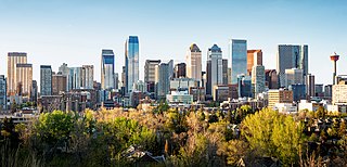
Calgary is a city in the Canadian province of Alberta. It is the largest city in Alberta and the largest metro area within the three Prairie Provinces region. As of 2021, the city proper had a population of 1,306,784 and a metropolitan population of 1,481,806, making it the third-largest city and fifth-largest metropolitan area in Canada.

Patricia Nelson née Black is a former provincial level politician from Alberta, Canada. As a member of the ruling Progressive Conservative Party of Alberta, she served as a Member of the Legislative Assembly of Alberta for the Calgary-Foothills electoral district from 1989 to 2004. During this time she served as a minister in a number of portfolios: Energy, Economic Development and Tourism, Government Services, and Finance. She also served as Deputy Government House Leader and as a member of Treasury Board.

Dead Man's Flats is a former Hamlet, now a Neighbourhood in Canmore, Alberta within the Municipal District of Bighorn No. 8. Statistics Canada also recognizes it as a designated place under the name of Pigeon Mountain. It is located within Alberta's Rockies at Highway 1 exit 98, approximately 7 kilometres (4.3 mi) southeast of Canmore and 78 kilometres (48 mi) west of Calgary.

<span class="mw-page-title-main">First Oil Well in Western Canada</span> Defunct oil well and national historic site of Canada

The First Oil Well in Western Canada, also known as Lineham Discovery Well No. 1, is a defunct oil well and national historic site of Canada. Which commemorates the September 21, 1902 oil strike in what is now Waterton Lakes National Park, Alberta. The oil well originally drilled in 1902, was the first productive oil well in the Western Canadian provinces.

<span class="mw-page-title-main">Outline of Alberta</span> Overview of and topical guide to Alberta

The following outline is provided as an overview of and topical guide to Alberta:

<span class="mw-page-title-main">Calgary White Hat</span> Variety of cowboy hat

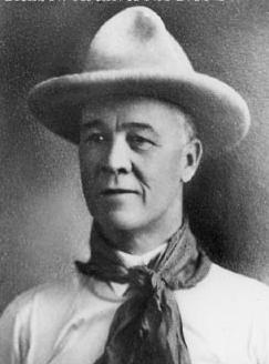
The Calgary White Hat is a white felt cowboy hat which is the symbol of both the Calgary Stampede annual rodeo and the city of Calgary. Created by Morris Shumiatcher, owner of Smithbilt Hat Company, it was worn for the first time at the 1946 Stampede. In the early 1950s, Mayor of Calgary Donald Hugh Mackay began presenting the white hat to visiting dignitaries, a tradition that the mayor's office continues to this day. Thousands of tourists and groups also participate in "white hatting ceremonies" conducted by Tourism Calgary and by volunteer greeters at the Calgary International Airport. In 1983, the Calgary White Hat was incorporated into the design of the flag of Calgary.

References

  1. "Business Plan" (PDF). Visit Calgary. Tourism Calgary. Retrieved 28 September 2023.
  2. Inglewood Main Street Archived 2007-02-27 at the Wayback Machine - Alberta Heritage
  3. Business Revitalization Zone - International Avenue