Downtown Markham, Ontario

Last updated
Downtown Markham
Downtown
Downtown Markham view from Hwy 407 2023.jpg
The skyline of Downtown Markham in 2023
Motto: 
the PLACE TO BE
Canada Ontario York Region locator map.svg
Red pog.svg
Location within York
Coordinates: 43°51′N79°19′W / 43.85°N 79.32°W / 43.85; -79.32
Country Flag of Canada (Pantone).svg  Canada
Province Flag of Ontario.svg  Ontario
Regional Municipality York
City Markham
DistrictMarkham Centre
Established1992 [1]
Area
[1]
  Total0.98 km2 (0.38 sq mi)
Population
 (2011)
  Total3,452 [2]
 Based on data for census tract 5350401.18 [3]
Postal code
L6G
Website Downtown Markham

Downtown Markham is the main downtown of Markham, Ontario, Canada. Currently under development, it is located within Markham Centre near the historic Unionville district and is proposed to serve as the heart of Markham. Businesses in the district are expected to employ up to 16,000 individuals, [4] [5] and it may house as many as 10,000 residents. [6] The development plans will have a high density of residential, retail, commercial and mixed-use structures. The community is being developed, built and wholly financed by The Remington Group Inc.

Contents

Description

Downtown Markham is a planned urban hub and the largest planned mixed-use development in Canada. The development spans 243 acres and is situated in one of the fastest growing regions in the province. It will be the commercial and financial district at the center of the city of Markham, and will consist of a mix of residential, office and retail uses.

Two million square feet of retail space will include international retailers, local shops, restaurants and entertainment venues. Downtown Markham will also offer more than 3.4 million square feet of office space in a commercial district adjacent to Highway 407.

The vibrant urban centre is being designed and developed following sustainable guidelines, including energy efficient power sources and LEED (Leadership in Energy and Environmental Design) certified residential and commercial projects. Aside from allowing greater density, the development also enjoys 72 acres of natural and landscaped green space, improved walkability and easy access to public transit, including Viva Rapid Transit and GO Transit.

Downtown Markham refers to an area south of Uptown Markham / Highway 7, west of Kennedy Road / Main Street Unionville, east of Warden Avenue, and north of Highway 407 ETR.

On the other hand, Markham Centre or Unionville refers to a broader area. Markham Centre is bounded north to Apple Creek Boulevard / Carlton Road, east to Kennedy Road, west to Rodick Road, and south to 14th Avenue.

History

Townhouses in Downtown Markham TownhousesDowntownMarkham.jpg
Townhouses in Downtown Markham
The Origin is the only one shopping arcade in Downtown Markham The Origin 2023.jpg
The Origin is the only one shopping arcade in Downtown Markham
Downtown Markham condo under construction in 2020. DowntownMarkhamCondoConstruction.jpg
Downtown Markham condo under construction in 2020.
New Downtown Markham condos in 2023 Downtown Markham new condos 2023.jpg
New Downtown Markham condos in 2023

The current City of Markham was created in 1971 when the original town was expanded by amalgamation with the surrounding namesake Markham Township which also contained the independent communities of Thornhill and Unionville. With its original historic downtown, Markham Village, being small and largely relegated to being a community node in the far eastern part of the amalgamated municipality, the city decided a larger, more centrally-located downtown was needed.

The area south of Highway 7 and east of Warden Avenue was frozen for development by the province during the planning and construction of express toll road Highway 407. In 1992, a plan was approved to develop the area with higher commercial density.

The Town of Markham has approved the plan, according to Markham's former mayor, Donald Cousens. [4] The new downtown was planned to be self-sustained and transit-oriented based on smart growth development. Construction began in 2005, when Enterprise Drive was completed.

Aviva Canada built its second Canadian headquarters on Birchmount Road and a new Cineplex theatre opened on April 4, 2015. It provides a bigger space to include a few VIP theatres, a new gaming corner and much higher capacity than the old Cineplex theatre at First Markham Place.

The Marriott hotel and the York condo was constructed on the corner of Enterprise Drive and Birchmount Road. It was finished by the end of 2018.

Development

Enterprise Blvd at Andre De Grasse Street in 2023 Enterprise Blvd at Andre De Grasse St 2023.jpg
Enterprise Blvd at Andre De Grasse Street in 2023

Downtown Markham is using a development strategy named smart growth. The community will try to limit urban sprawl by creating a denser urban centre. The urban centre is planned to be a transit-oriented community, with everything close by and fully transit dependent. [5] In addition, the community was also planned to be environmentally sustainable as well.

The community was planned by the City of Markham, in cooperation with The Remington Group. The Remington Group is mainly in charge of constructing most of the structures across this new community.

According to the plan approved by the city council, the community will contain residential condos and townhouses, commercial, and retail buildings. [4] Some of these structures have already begun construction. Updates as to what is built is underway.

Downtown Markham has been nominated as the country's largest mixed-used development, as well as North America's largest LEED (leadership-in-energy-and-environmental-design) registered development. [7]

Transportation

Warden Vivastation WardenVIVA3.JPG
Warden Vivastation

The primary modes of transportation in Downtown Markham are: Regional Roads, municipal roads, a toll highway, bus rapid transit, and GO Trains. [5]

Arterial Roads

The downtown area is bounded with three arterial streets, which are numbered York Regional Roads: Kennedy Road (York Road 3), Highway 7 (York Road 7, which was formerly Provincial Highway 7), and Warden Avenue (York Road 65).

Toll Highway

Highway 407 serves the area with exits on Warden Avenue and Kennedy Road.

Bus Rapid Transit

The community is served by the Warden, Enterprise and Unionville stops on the VIVA bus rapid transit system. Warden and Enterprise are served by three lines: Viva Purple, Viva Green, and Viva Pink, while Unionville Station is only served by Viva Pink. As of 2011, Viva Purple is the only line with all-day service, the other lines operate only during rush hour. It is scheduled that when Downtown Markham is fully functional and occupied, Viva Green will return to full service. The community is anticipated to be highly dependent on these transit routes, as part of the planned smart growth.

Viva Purple connects the locale to Cornell and York University; Viva Green connects the locale to Don Mills Station and Cornell; Viva Pink connects the locale to North York City Centre.

Other bus routes that serve the area include:

GO Transit

GO Transit operates Unionville GO Station on the Stouffville line during peak commuter traffic. The GO train line connects the Downtown Markham to Stouffville and Downtown Toronto.

Environmental sustainability

Rouge River at Birchmount Road (with condo buildings at Downtown Markham in the background) RougeRiverMarkham.jpg
Rouge River at Birchmount Road (with condo buildings at Downtown Markham in the background)

The community reserves 72 acres (290,000 m2) as a natural reserve, which includes an ecologically sensitive area, Rouge River.

Facilities

There are two recreational facilities in Downtown Markham:

Education

The York University Markham Campus is currently being built next to the Markham Pan Am Centre.

Related Research Articles

<span class="mw-page-title-main">Markham, Ontario</span> City in Ontario, Canada

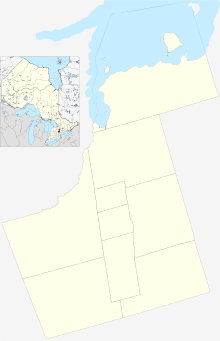
Markham is a city in York Region, Ontario, Canada. It is approximately 30 km (19 mi) northeast of Downtown Toronto. In the 2021 Census, Markham had a population of 338,503, which ranked it the largest in York Region, fourth largest in the Greater Toronto Area (GTA), and 16th largest in Canada.

<span class="mw-page-title-main">Rouge River (Ontario)</span> River in Ontario, Canada

The Rouge River is a river in Markham, Pickering, Richmond Hill and Toronto in the Greater Toronto Area of Ontario, Canada. The river flows from the Oak Ridges Moraine to Lake Ontario at the eastern border of Toronto, and is the location of Rouge Park, the only national park in Canada within a municipality. At its southern end, the Rouge River is the boundary between Toronto and southwestern Pickering in the Regional Municipality of Durham.

Buttonville is a suburban neighbourhood and former hamlet in the city of Markham, Ontario, Canada, bordering the larger Unionville district. The hamlet was named after its founder, John Button.

<span class="mw-page-title-main">Unionville, Ontario</span> Suburban district in York, Ontario, Canada

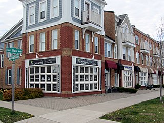
Unionville is a suburban district and former village in Markham, Ontario, Canada, 2 km (2.5 mi) northeast of Downtown Markham, 2 km (2.5 mi) west of Markham Village, and 33 km (20.5 mi) northeast of Downtown Toronto. The boundaries of Unionville are not well-defined. Several nearby neighbourhoods are claimed to be part of it however, this has been disputed between the various wards.

<span class="mw-page-title-main">Unionville GO Station</span> Railway station in Markham, Ontario, Canada

Unionville GO Station is a train and bus station in the GO Transit network located in Markham, Ontario, Canada. It is a stop on the Stouffville line. The station is also served by Highway 407 East Express buses, which run westbound to Highway 407 station, northbound to Mount Joy GO Station, and eastbound to the Oshawa GO station.

<span class="mw-page-title-main">Centennial GO Station</span> Railway station in Markham, Ontario, Canada

Centennial GO Station is a train station on the GO Transit Stouffville line in Markham, Ontario, Canada. The station is located directly west of McCowan Road and north of Bullock Drive, near the Markham Centennial Park.

<span class="mw-page-title-main">Viva Rapid Transit</span> Express bus network in York Region, Ontario

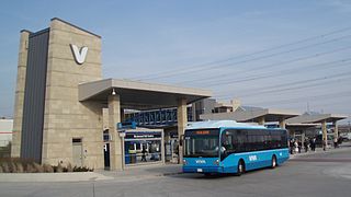
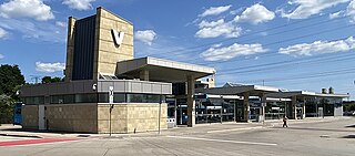
Viva is the bus rapid transit operations of York Region Transit in York Region, Ontario, Canada. Viva service forms the spine for YRT's local bus service, providing seamless transit service across York Region with connections to northern Toronto.

<span class="mw-page-title-main">Richmond Hill Centre Terminal</span> Bus terminal in Richmond Hill, Ontario

Richmond Hill Centre Terminal is a York Region Transit, Viva, and GO Transit bus terminal in Richmond Hill, Ontario. Despite its name, the terminal is not located in downtown Richmond Hill, but is situated 4 km to the south at the city's southern limits, bordering Vaughan and Markham, near the connecting road that links the grade-separated Yonge Street and Highway 7 intersection. It opened on September 4, 2005. It is immediately west of the Langstaff GO train station, but is separated by the tracks. A pedestrian bridge over the tracks was opened in March 2008 to connect the bus terminal and the train station. Public washrooms were added to the terminal in December 2012.

<span class="mw-page-title-main">Cornell Terminal</span> Bus station in Markham, Ontario

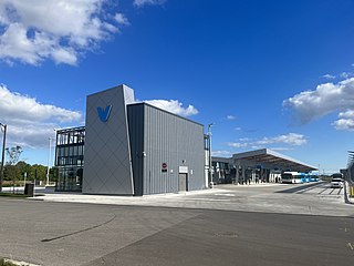
Cornell Terminal is a York Region Transit bus terminus on a site immediately south of Markham Stouffville Hospital in Markham, Ontario, Canada. The station opened in September 2022 and includes a passenger pick-up and drop-off area, a public plaza, and future retail space.

<span class="mw-page-title-main">Cornell, Markham</span> Planned Community in Ontario, Canada

Cornell is a neighbourhood in northeast Markham, Ontario and bounded by Highway 407, 16th Avenue, Ninth Line, and the Donald Cousens Parkway. The 2011 population of this area was 9,880. Adding Cornell North's 2,178 it has 12,058 residents.

<span class="mw-page-title-main">Vaughan Metropolitan Centre</span> City centre in Ontario, Canada

Vaughan Metropolitan Centre is the city centre of Vaughan, Ontario, Canada. Measuring 179 hectares, the district is located at the intersection of Highway 7 and Jane Street, northeast of the Highway 400 and Highway 407 interchange, at the site of the historic farming community of Edgeley within the larger district of Concord. The district is served by the TTC subway station of the same name, which is the northwestern terminus of Line 1 Yonge–University of the Toronto subway system. It is also a major transit hub for York Region Transit (YRT), as well as Viva and Züm bus rapid transit services.

<span class="mw-page-title-main">Angus Glen</span> Neighbourhood in Ontario, Canada

Angus Glen is a suburban neighbourhood in the city of Markham. It is roughly bounded by Warden Avenue on the west, Kennedy Road on the east, Sixteenth Avenue on the south, and Major Mackenzie Drive on the north. Developed in the late 1990s, the original Angus Glen East Village, comprising approximately 500 single family homes and townhouses, was planned with the "New Urbanism" concept, to allow for the homes to be designed with the appearance of historic houses, with separate garages on rear laneways. In the mid-2000s the land west of the small creek on the west border of the East Village section commenced development, and is still under construction, known as the West Village. Throughout this period the East Village had a tract of land which had originally been sold to the school board for a possible school. However, the demographic studies could not support a school and after many years of negotiations the developer re-purchased the land in early 2014 and the East Village has had approximately 50 homes under construction, just east of the baseball park and along the north border of York Downs Golf Club. These homes will increase the East Village's homes to close to 600 and the entire community to approximately 1,100.

Hagerman's Corners is a dispersed rural community in Markham, Ontario, Canada. Located at 14th Avenue and Kennedy Road, the former farm lands have disappeared and given way to homes and commercial parks. It is geographically located between the communities of Milliken Mills and Unionville, within the city of Markham.

<span class="mw-page-title-main">Berczy Village</span> Neighbourhood in York, Ontario, Canada

Berczy Village is a residential neighbourhood in Markham, Ontario, Canada. It is bounded to the north by Major Mackenzie Drive, to the east by McCowan Road, to the south by 16th Avenue, and to the west by Kennedy Road. This area is north of Unionville. The community is named after William Berczy, Markham's founder. The name is shown on limestone plaques throughout the community's arterial road entrances.

The city of Markham in Ontario, Canada, offers a complex transportation infrastructure. These include airports, highways, public transit, regional roads, municipality-funded roads, and train services.

<span class="mw-page-title-main">Markville Shopping Centre</span> Shopping mall in Markham, Ontario, Canada

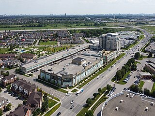
CF Markville, also known as Markville Shopping Centre in the Cadillac Fairview chain of malls, is a shopping mall of over 140 stores in Markham, Ontario, Canada. It is located at the intersection of Highway 7 East and McCowan Road, and runs along Bullock Drive, located slightly west of McCowan Road. Its anchors are Hudson's Bay, Winners, Walmart Supercentre, Decathlon, Sporting Life, Marshalls, Uniqlo, Best Buy, and a Toys "R" Us/Babies "R" Us combo store. It has a gross leasable area of 981,000 square feet (91,100 m2). It was the largest shopping mall in York Region until 2004 when Vaughan Mills opened.

Markham Village is the historic town centre of Markham, Ontario, Canada. Originally settled in 1825, the village, which was originally named "Reesorville" sometime after 1804 and also known as "Mannheim", was founded by Mennonites from Upstate New York and Pennsylvania. Eventually, as Upper Canada started to experience immigration from the British Isles, Markham would experience significant growth. By 1825, the name "Markham" was established as the permanent name. In 1850, it was established as a police village, and in 1873 was fully incorporated as a village within York County. Markham was amalgamated with the surrounding Markham Township, which included the villages of Unionville and Thornhill in 1971, and incorporated as a town.

<span class="mw-page-title-main">Highway 7 Rapidway</span> Bus transit right-of-way in York Region, Canada

The Highway 7 Rapidway in York Region, Ontario, Canada, is a bus rapid transit right-of-way that runs from Bruce Street in Vaughan to Birchmount Road in Markham. There are plans to extend it west to Highway 50 and east to Cornell Terminal. It is served by Viva Purple, Viva Pink, and Viva Orange bus routes.

<span class="mw-page-title-main">Langham Square</span> Shopping mall in Ontario, Canada

Langham Square is a 500,000-square-foot (46,000 m2) Asian-themed shopping, office and residential complex in Markham, Ontario, Canada. It is located at the intersection of Kennedy Road and South Unionville Avenue, which is north of the 407 ETR and east of Downtown Markham. Its Chinese name “朗豪坊” echoes Langham Place, a shopping and office complex located in Mong Kok, Hong Kong.

References

  1. 1 2 "Downtown Markham:About". 2006. Retrieved 2007-10-12.
  2. "Statistics Canada 2011 Census Tract Profile for CT 5350401.18". 2011. Retrieved 2015-07-06.
  3. This census track includes some area that are not considered as part of Downtown Markham, though this "extra" area is largely uninhabited and are mostly of industrial lands.
  4. 1 2 3 Guelph Civic League. "Downtown Markham Makeover". Archived from the original on August 16, 2006. Retrieved 2008-06-16.
  5. 1 2 3 The Toronto Star (2007-08-11). "Digging for an elusive dream". The Star. Retrieved 2008-06-16.
  6. Remington Group, and the Town of Markham (March 2006). "Downtown Markham Facts at a glance" (PDF). Archived from the original (PDF) on 2006-10-05. Retrieved 2007-10-12.
  7. 100 Thousand Club. "New York. Paris. London. Toronto?" (PDF). Archived from the original (PDF) on 2011-07-06. Retrieved 2008-06-16.{{cite web}}: CS1 maint: numeric names: authors list (link)