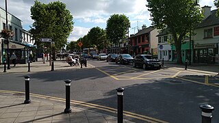
Swords is the county town of Fingal and a large suburban town on the Northside of Dublin. Lying ten kilometres north of the city centre, on the Ward River, and reputedly founded around 560 A.D., it features a restored medieval castle, a holy well from which it takes its name, a round tower and a Norman tower. Near to Dublin Airport, Swords is also home to one of the Dublin region's larger shopping centres, The Pavilions, extensive other retail facilities and a range of industries. Extensive suburban housing estates lie around the town centre, with several parks and many schools and sporting facilities.
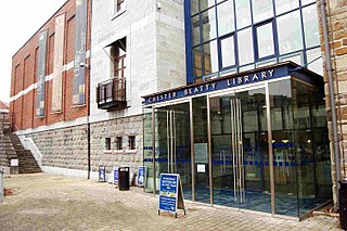
The Chester Beatty is a museum and library in Dublin. Formerly known as the Chester Beatty Library, it was established in Ireland in 1950, to house the collections of mining magnate, Sir Alfred Chester Beatty. The present museum, on the grounds of Dublin Castle, opened on 7 February 2000, the 125th anniversary of Beatty's birth and was named European Museum of the Year in 2002.
The documented history of Islam in Ireland dates to the 1950s. The number of Muslims in Ireland has increased since the 1990s, mostly through immigration. According to the 2016 Irish census the number of Muslims resident in the Republic was 63,443.

Portobello is an area of Dublin located in the South City Centre, bounded to the south by the Grand Canal.

Clonskeagh or Clonskea, is a small southern suburb of Dublin, Ireland. The district straddles the River Dodder.

Phibsborough, also spelled Phibsboro, is a mixed commercial and residential neighbourhood on the Northside of Dublin, Ireland.
The South Circular Road is a road in Dublin, Ireland, one of the longest in the city. It runs from Kilmainham in the west of the city, through Rialto and Dolphin's Barn to Portobello, near the centre. As it runs mainly through residential areas, it is used by numerous bus routes.
Donaghmede is a residential suburb on the northern side of Dublin, Ireland, formed from parts of Baldoyle, Coolock and Raheny in the 1970s. It contains a mid-size shopping centre and a ruined chapel, and lies within the jurisdiction of Dublin City Council.
Frank Edwards was a teacher and prominent Irish communist.

The Islamic Cultural Centre of Ireland is an Islamic complex, including a mosque, in Clonskeagh, Dublin, Ireland. It is funded by the al-Maktoum Foundation of Dubai and has a Sunni orientation.
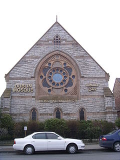
The Islamic Foundation of Ireland was formed in 1959 by Muslim students in Ireland. The society established the first mosque in Ireland in 1976. It also helped to establish mosques in other cities in the country. The headquarters of the foundation is currently at the Dublin Mosque and Islamic Centre, 163 South Circular Road, Dublin 8. The Islamic Foundation of Ireland has been the official representative of Muslims in Ireland since its inception. It describes its role as looking after the religious, educational and social needs of Muslims in Ireland.

The R117 road is a regional road in Ireland. The route (north-south) starts Harcourt Road at the end of the South Circular Road on the southside of Dublin city centre. It crosses the Grand Canal and goes through the suburbs of Ranelagh, Milltown, Windy Arbour, Dundrum, Sandyford, Stepaside and Kilternan before passing through the Scalp into County Wicklow.

Clongriffin is a growing community in northern Donaghmede, on the northern fringe of Dublin, Ireland. The settlement was based on a master plan vision from major developer Gannon Homes, with significant investment in transport infrastructure and also community and recreational amenities. Development slowed during the downturn in the economy, although activity renewed in recent years, with planning permission secured for a hotel and range of additional homes including a 16-storey apartment block with residential lounges and roof gardens..
Rialto is an inner suburb of Dublin, situated on the city's southside.

The North Circular Road - designated as R101 regional road - is an important thoroughfare on the northside of Dublin, in Ireland. The regional road was long considered the northern boundary of the city and still separates the city centre from the inner suburbs. It runs from the Phoenix Park in the west through Phibsboro, to North Wall in the east. A number of important institutions are located along the road, including the Mater Hospital, Dalymount Park and Mountjoy Prison, and both Croke Park and St. Brendan's Hospital are nearby. The R101 and the NCR overlap for most of their lengths, and the entire NCR forms a section of the R101. In the west the R101 connects the NCR to Parkgate Street via the short Infirmary Road ; at the eastern end the R101 becomes Portland Row after the junction with Summerhill. It continues the northern loop through Saville Place , then turning east for its final kilometre via Sheriff Street (Upper) before terminating at North Wall Road.

The R111 road is a regional road in south Dublin, Ireland, and includes a major element of the Dublin Outer Orbital Route.

The R147 is a regional road in Ireland. Its first section runs from St Peters Church in Phibsborough, Dublin to its junction with the M50. It then follows the route of a former section of the N3 between Clonee and Kells. It serves as an alternative route for non-motorway traffic and traffic wishing to avoid tolls on the M3.

The R811 road is a regional road in Dublin, Ireland.
Kirwan House or The Female Orphan House was a protestant run female orphanage on Dublin's North Circular Road.

Ahmadiyya is an Islamic community in Ireland under the spiritual leadership of the caliph in London. The Community was formally registered in the country in 1992, during the era of the Fourth Caliphate. Today there are two Ahmadiyya mosques in the country, one of which is purpose-built, representing up to 500 Ahmadi Muslims in the country.

