Clarence Township is a civil township located in northeast Calhoun County in the U.S. state of Michigan. It is part of the Battle Creek, Michigan Metropolitan Statistical Area. The population was 1,985 at the 2010 census. The township was originally named Pinkney Township.

Hunters Creek Village is a city in Harris County, Texas, United States, part of the Greater Houston metropolitan area. The population was 4,385 at the 2020 census. It is part of a collection of upscale residential communities in west Houston known as the Memorial Villages.
Saint Johns is an unincorporated community in northwest St. Johns County, Florida, United States and a suburb of Jacksonville. The population as of the 2000 census was 18,063, though considerable growth has taken place in the past ten years. As of 2016, the population is estimated to be approximately 86,400 people. It is located in the Jacksonville metropolitan area, and lies approximately halfway between downtown Jacksonville and downtown St. Augustine.
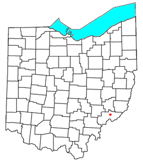
Whipple is an unincorporated community in southern Salem Township, Washington County, Ohio, United States. Although it is unincorporated, it once had a post office, with the ZIP code 45788. It lies on State Route 821 south of the village of Lower Salem, at the junction of Whipple Run with Duck Creek. The community took its name from nearby Whipple Run.
Riddle is an unincorporated community in the southwestern part of the U.S. state of Idaho, in Owyhee County. Located on SH-51, it is 13 miles (21 km) north of the border with Nevada and 79 miles (127 km) south of Mountain Home. The community lies at the north edge of the Duck Valley Indian Reservation.

Crosswicks is an unincorporated community located within Chesterfield Township in Burlington County, New Jersey, United States. The area is served as United States Postal Service ZIP code 08515.
Grouse Creek is an unincorporated community in the nearly unpopulated northwestern region of Box Elder County, Utah, United States, near the Idaho and Nevada borders. The community lies along unpaved roads north of State Route 30 in the Grouse Creek Mountains. Its elevation is 5,331 feet (1,625 m). It has a post office with the ZIP code 84313.
Fruitland is an unincorporated community in western Duchesne County, Utah, United States, on the Uintah and Ouray Indian Reservation.
Lapoint is an unincorporated community in western Uintah County, Utah, United States.

Mountain Home is an unincorporated community in central Duchesne County, Utah, United States, adjacent to the Uintah and Ouray Indian Reservation.

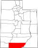
Teasdale is a census-designated place in western Wayne County, Utah, United States, between the Dixie and Fishlake National Forests and near Capitol Reef National Park. The population was 191 at the 2010 census. Teasdale lies along local roads south of State Route 24, southeast of the town of Loa, the county seat of Wayne County. Teasdale has a post office with the ZIP code 84773.

Old Zionsville is an unincorporated community in Upper Milford Township, Lehigh County, Pennsylvania. It is part of the Lehigh Valley, which has a population of 861,899 and is the 68th most populated metropolitan area in the U.S. as of the 2020 census.

Shartlesville is a census-designated place in Upper Bern Township, Berks County, Pennsylvania. As of the 2010 census, the population was 455 residents.
Trout Creek is an unincorporated community, in far western Juab County, Utah, United States.

Palm is an unincorporated community in Montgomery County, Pennsylvania, United States. It lies along Pennsylvania Route 29 between Hereford and East Greenville at latitude 40.4281539 longitude −75.5329608. It is located in Upper Hanover Township and the ZIP code is 18070. The Hosensack Creek flows from the northeast into the Perkiomen Creek in the village.
Duck is an unincorporated community along the border of Braxton and Clay counties in West Virginia, United States. Duck is 11.5 miles (18.5 km) northeast of Clay. Duck has a post office with ZIP code 25063.

Spinnerstown is a census-designated place in Milford Township, Bucks County, Pennsylvania. It is located just NW of the Quakertown interchange of I-476 with Route 663. As of the 2010 census, the population was 1,826 residents.

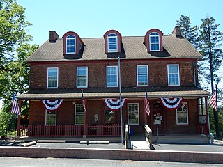
Springtown is an unincorporated community in Springfield Township in extreme northern Bucks County, at the junction of Routes 212 and 412 and is drained by the Cooks Creek east into the Delaware River. Springtown has two churches, and is home to the Springtown Inn. The village has its own Post Office with the ZIP code 18081. Surrounding areas use the Coopersburg ZIP code of 18036 and the Hellertown ZIP code of 18055. Springtown's 346 telephone exchange is in Area Code 610.
Zionhill is an unincorporated community located in Springfield Township, Bucks County, Pennsylvania, on Old Bethlehem Pike east of the Unami Creek. While the village has its own box post office with the ZIP code of 18981, surrounding areas use the Coopersburg ZIP code of 18036 or the Quakertown ZIP code of 18951.
Sassamansville (SAS-a-minz-vil) is an unincorporated community in northwest Montgomery County on Hoffmansville Road approximately 1 1/2 miles NW of Route 663. It is located mainly in New Hanover Township but also in Douglass Township and is served by the Boyertown Area School District. It is drained by the Swamp Creek into the Perkiomen Creek. The Sassamansville telephone exchange uses area code 610. While the village has its own box post office with the zip code of 19472, portions of Sassamansville are served by the Barto, Gilbertsville, and Perkiomenville post offices with zip codes of 19504, 19525, and 18074, respectively. The community is home to The Bauman Family fruit butter factory.