
Glasgow Central is one of two principal mainline rail terminals in Glasgow, Scotland. The railway station was opened by the Caledonian Railway on 1 August 1879 and is one of 20 managed by Network Rail. It is the northern terminus of the West Coast Main Line. As well as being Glasgow's principal inter-city terminus for services to England, Central also serves the southern suburbs of the Greater Glasgow conurbation, as well as the Ayrshire and Clyde coasts. The other main station in Glasgow is Glasgow Queen Street.
The Paisley Canal line is a branch railway line in Scotland running between Glasgow and Paisley. The line currently terminates at Paisley Canal railway station, although it previously continued through Paisley West station, near Ferguslie, to Elderslie junction where it met and crossed under the main Glasgow and South Western Railway line running from Paisley Gilmour Street station to Johnstone, and beyond. After Elderslie, the line terminated at North Johnstone, however another junction allowed services from the Paisley Canal line to continue onto the Bridge of Weir Railway and Greenock and Ayrshire Railway to the latter's terminus at Greenock Princes Pier.
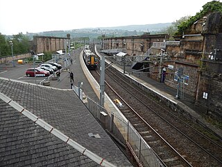
Greenock Central station is one of eight railway stations serving the town of Greenock in western Scotland, and is the nearest to the town centre. This station, which is staffed, is on the Inverclyde Line, 37 km (23 mi) west of Glasgow Central towards Gourock. It has three platforms, two of which are in use, with one disused bay platform. This disused platform is still connected to the main line.

Paisley Gilmour Street railway station is the largest of the four stations serving the town of Paisley, Renfrewshire, Scotland, and acts as the town's principal railway station. The station is managed by ScotRail and serves the Ayrshire Coast Line and Inverclyde Line, 7+1⁄4 miles (11.7 km) west of Glasgow Central. The station is protected as a category B listed building.
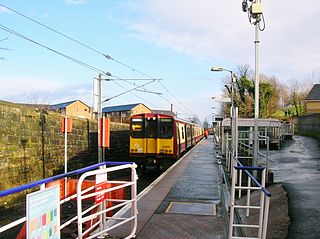
Hawkhead railway station is a railway station in the Seedhill area of Paisley, Renfrewshire, Scotland. The station is managed by ScotRail and lies on the Paisley Canal Line, 6½ miles (10 km) west of Glasgow Central.

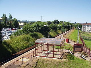
Kilmaurs railway station is a railway station in the town of Kilmaurs, East Ayrshire, Scotland. The station is managed by ScotRail and is on the Glasgow South Western Line.
Hawkhead is an area near Paisley in Renfrewshire, Scotland.
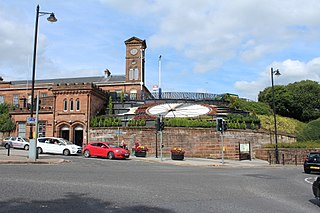
Kilmarnock railway station is a railway station in Kilmarnock, East Ayrshire, Scotland. The station is managed by ScotRail and is served by trains on the Glasgow South Western Line. One of the earliest railway stations in Scotland, the Kilmarnock and Troon Railway opened on 6 July 1812, until it was replaced by the Glasgow, Paisley, Kilmarnock and Ayr Railway on 4 April 1843.
The City of Glasgow Union Railway - City Union Line, also known as the Tron Line, was a railway company founded in Glasgow, Scotland, in 1864 to build a line connecting the railway systems north and south of the River Clyde, and to build a central passenger terminus and a general goods depot for the city. The through line, running from south-west to north-east across the city, opened in 1870–71, and the passenger terminal was St Enoch railway station, opened in 1876. The railway bridge across the Clyde was the first in the city.
Dykebar is a small residential estate at the south-easternmost periphery of Paisley, Renfrewshire, Scotland, close to the local authority boundaries with both East Renfrewshire and Glasgow. It is situated next to the Hawkhead area, with other neighbourhoods in the vicinity including Thornly Park, Lochfield, Hunterhill and Blackhall. Dykebar is home to Paisley's general psychiatric hospital, and is approximately 1.2 miles (1.9 km) from both Barrhead and Nitshill.
The Dalry and North Johnstone Line was a branch of the Glasgow and South Western Railway (G&SWR) in Renfrewshire and Ayrshire, Scotland, connecting the stations in Elderslie and Dalry via a route running parallel to the existing line built by the Glasgow, Paisley, Kilmarnock and Ayr Railway. This provided additional line capacity for Ayrshire Coast and Kilmarnock services. The loop line was used for passenger services until the mid-1960s, when it was closed by the Beeching Axe. The majority of the line's trackbed has since been absorbed into the Sustrans National Cycle Network.
The Cathcart District Railway was proposed to serve the arising demand for suburban residential travel on the south side of Glasgow, Scotland. It was planned as a loop running to and from Glasgow Central station, but at first only the eastern arm, to Cathcart via Queens Park, was built, opening in 1886. The western arm was opened in 1894 and trains operated round the loop. A frequent passenger train service was operated, and there was also a limited goods and mineral operation.
The Barrhead Branch was a branch line built by the Glasgow and South Western Railway in Scotland. It connected Potterhill railway station on the south side of Paisley with a new Barrhead Central railway station. The line was sometimes known as the Barrhead Central Railway.
The Paisley and Barrhead District Railway was a railway in Scotland that ran between the towns of Paisley and Barrhead. It was intended to serve industrial premises and develop local passenger and goods business.

Ferguslie was a railway station to the west of Paisley, Renfrewshire, Scotland. It was constructed as a planned extension of railway passenger services in the Paisley area by the Paisley and Barrhead District Railway, which opened in 1897, but none of the stations opened for passengers. The line was only used for freight services and closed in 1960s. The track has been lifted and the station buildings removed.

Paisley East was an unopened railway station in Paisley, Renfrewshire, Scotland.

Stanely was a railway station to the west of Paisley, Renfrewshire, Scotland.
Glenfield was a railway station to the south west of Paisley, Renfrewshire, Scotland.

Barrhead (New) was one of four railway stations in Barrhead, Renfrewshire, Scotland.
Southside railway station, Glasgow, Scotland, was an early passenger terminal situated in the Gorbals area of the city. The station opened on 29 September 1848, for trains operated by the Glasgow, Barrhead and Neilston Direct Railway, which a short time later was absorbed by the Caledonian Railway.
