Paisley and Barrhead District Railway

Last updated

Contents

Paisley and Barrhead District Railway
BSicon CONTg.svg
BSicon CONTgq.svg
BSicon eABZq+r.svg
BSicon STR2+r.svg
BSicon UWu3.svg
BSicon exSTR3+l.svg
BSicon eABZgr+r.svg
Walkinshaw North
& South Junctions
Ferguslie
BSicon exSTR+c2.svg
BSicon exlvBST@F-.svg
BSicon exSTR3+1u.svg
BSicon v-STR+4.svg
BSicon HST.svg
Paisley St James
BSicon exSTRc2.svg
BSicon exKRZ3+1o.svg
BSicon exSTRc4.svg
BSicon dBHF-L.svg
BSicon BHF-R.svg
Paisley
Gilmour Street
Stanely
BSicon exBST+1.svg
BSicon exSTR+c4.svg
BSicon v-SHI1l.svg
BSicon BS2r.svg
Wallneuk Junction
Glenfield
BSicon exBST.svg
BSicon exABZg2.svg
BSicon exSTRc3.svg
BSicon ebvvWSLg+rxl.svg
Arkleston Junction (
unbuilt
connection
)
BSicon exSTR.svg
BSicon exSTRc1.svg
BSicon exABZg+l.svg
BSicon exSTR+4.svg
BSicon exSTR+r.svg
BSicon exSTR.svg
BSicon CONTf.svg
Paisley
West
BSicon exSTR.svg
BSicon exSTR.svg
BSicon exHST.svg
BSicon exBST.svg
Paisley East
Potterhill
BSicon exSTR.svg
BSicon exHST.svg
BSicon KHSTxa.svg
BSicon exSTR.svg
Paisley
Canal
BSicon exSTR2.svg
BSicon exSTR3u.svg
BSicon exSTR2.svg
BSicon exSTRc3.svg
BSicon STRl.svg
BSicon xKRZo.svg
BSicon CONTfq.svg
Gleniffer Goods Depot
(Barrhead Branch G&SWR)
BSicon exUWu1.svg
BSicon exKDST1.svg
BSicon exSTR+4+c1.svg
BSicon exSTR2u+4.svg
BSicon exBST3@g.svg
Dykebar
BSicon exSTR+c2.svg
BSicon exSTRc2.svg
BSicon exSTR3+1.svg
BSicon exUWu4.svg
BSicon exABZ4+3f.svg
Blackbyres West Junction
BSicon exSTR2+1.svg
BSicon exSTR2.svg
BSicon exUWu3.svg
BSicon exSTRc4.svg
BSicon exSTR3+1.svg
BSicon exSTR+c4.svg
BSicon exSTR+1u.svg
BSicon exSTR2+4.svg
BSicon STR3+l.svg
BSicon exUWu3.svg
BSicon exSTRl.svg
BSicon CONTfq.svg
BSicon xSTR2u.svg
BSicon STR3+1.svg
BSicon exUWu1.svg
BSicon exSTR+1.svg
BSicon exSTR2+4.svg
BSicon exSTRc3.svg
Barrhead
BSicon STRc2.svg
BSicon HST3+1.svg
BSicon exSTR2.svg
BSicon xSTR2+4u.svg
BSicon exSTRc13.svg
BSicon exBST+4.svg
Barrhead (New)
BSicon CONT1.svg
BSicon STRc4.svg
BSicon exSTRc1.svg
BSicon exdKHST4-.svg
BSicon exdSTRc2.svg
BSicon exSTR3.svg
Barrhead
Central
BSicon exBST+1.svg
BSicon STRc4.svg
Barrhead South
BSicon CONTgq.svg
BSicon eABZql.svg
BSicon edHSTq.svg
BSicon dCONTfq.svg
Lyoncross

The Paisley and Barrhead District Railway was a railway in Scotland that ran between the towns of Paisley and Barrhead. It was intended to serve industrial premises and develop local passenger and goods business.

The Caledonian Railway managed the construction, but when the line was nearly complete, tramway competition had become obviously dominant for local passenger journeys, and the Caledonian decided not to start the intended passenger service. The line opened for goods trains only in 1905 and 1906, and served industrial sites on the route. Most of the line had become moribund by the 1950s, but when the Linwood motor car factory opened in 1961, a rail connection to it was provided from the line, becoming the only part of the network still in use. That link was closed in 1984.

History

First railways

Paisley had long been an important manufacturing town, especially in the textile industries. [1] [ page needed ] When main line railways in the west of Scotland were being planned in the 1830s, it was natural that the town would be considered an important intermediate point, and in 1840 the Glasgow, Paisley, Kilmarnock and Ayr Railway opened; the following year the Glasgow, Paisley and Greenock Railway opened its line too. The two companies shared, and jointly operated, a route between Glasgow and Paisley, the Glasgow and Paisley Joint Railway.

Those two railway companies were later merged with others, and became part of the Glasgow and South Western Railway (G&SWR) and the Caledonian Railway respectively. The two larger companies were keen rivals and over time expanded their area of influence in Scotland.

The Barrhead and Neilston areas were already the home to much industrial activity, especially in the valley of the Levern Water, and in 1848 the Glasgow, Barrhead and Neilston Direct Railway opened. In 1873 that line was extended to Kilmarnock and transferred to joint control of the Caledonian and the G&SWR companies; the extended line was called the Glasgow, Barrhead and Kilmarnock Joint Railway (GB&KJR).

In the later decades of the nineteenth century, there was considerable further industrial development in areas not directly served by the earlier lines. This was particularly the case in Paisley, where much industry was established south of the town, and in 1885 the G&SWR opened the Paisley Canal Line which ran from Glasgow to Elderslie on a more southerly alignment than the Joint Line. The following year it extended that line by a branch to Potterhill, and in doing so served a considerable area of industrial activity. [1] [ page needed ] [2] [ page needed ]

Linking Paisley and Barrhead

The Paisley and Barrhead District Railway system Paisley & Barrhead Dist.gif
The Paisley and Barrhead District Railway system

The centres of Paisley and Barrhead are about five miles (8 km) apart, and the spread of Paisley industry towards Barrhead, and the location of much of Barrhead industry on the Paisley side encouraged the idea of linking them. As well as the goods traffic that might be captured, suburban passenger business could be assumed to be attracted. Residential traffic had been increasing in other localities; moreover a circular service from Glasgow through both towns had operational benefits.

In 1898 the G&SWR obtained an Act of Parliament authorising a line from its Potterhill terminus to Barrhead, there joining the GB&KJR. The line opened in 1902 and a circular passenger service was operated from Glasgow. [2] [ page needed ] [3] [ page needed ]

Paisley and Barrhead District Railway: authorisation and construction

This was preceded on 6 August 1897 when the Paisley and Barrhead District Railway was authorised. It was nominally independent, but friendly to the Caledonian, and was intended as a competitive response to the G&SWR route. It was to be a complex system amounting to over 12 miles (20 km), making several linkages with existing lines. [4] [ page needed ] It was supported by the Caledonian Railway: £132,000 of the £188,000 capital was provided by the larger company. [5] [ page needed ]

Its route was to leave the Caledonian Railway's Greenock line at Paisley St James and turn south to the foot of the Gleniffer Braes, then east, turning south again to enter the centre of Barrhead. Unlike the G&SWR scheme, it was to continue beyond Barrhead, and was to join the Lanarkshire and Ayrshire Railway, authorised in the same Parliamentary session, at a junction between Neilston and Cathcart.

A second arm of the network was to connect with the Glasgow and Paisley Joint Railway by a triangular junction immediately east of Paisley Gilmour Street, running south and joining the other section at a junction at Blackbyres, a short distance north of Barrhead. This section would give access for coal traffic from the Lanarkshire pits directly to Paisley, and was to be double track to handle the heavy trains.

Construction of the line started on 15 August 1898. The route had been designed to skirt existing heavily built up areas, and construction was easy except in the approaches to Barrhead and Paisley East: here the possible alignment was limited by the hilly topography, the River Levern, the existing Kilmarnock line, and the authorised G&SWR line. Two massive stone viaducts were required in Barrhead. (The town of 9,000 inhabitants was to have four passenger stations.) [3] [ page needed ] [6] [ page needed ] An enormous stone wall was built along the length of Lacy Street in Paisley to take the line to Paisley East as can be seen in the bridge photograph on this page.

Having subscribed two-thirds of the original capital of the company in 1898 the Caledonian put in a further £80,000 in 1900, and obtained Parliamentary authority for an extension of time for construction in 1901. It acquired the company outright in 1902 (by Act of 31 July), while construction was still in progress. The G&SWR Barrhead Central station, on its line from Paisley, opened on 1 October 1902.

A further extension of time for the District Railway was obtained in 1904.

For some time street-running tramcars had been making heavy inroads into urban and suburban passenger railway business, and electric tramcar routes were proliferating. The frequent trams, the convenience of stopping places in town and village centres, and the cheap fares were major advantages to which local railways could not respond. In May 1905 the Caledonian opposed the Paisley tramway operation's proposed route from Paisley to Barrhead: it said that the District Railway was to open on 1 June 1905, and that the company had spent £720,000 on the Paisley lines; the Company said that it "made a feature of workmen's trains". [5] [ page needed ] [7] [ page needed ]

Opening and route

The tramway was authorised, and the desperate struggle to compete for local passenger business was obviously lost; the Caledonian reviewed its position, and although the passenger stations were substantially complete, it decided not to open the line for passengers. The western section, from Paisley St James to Blackbyres and Lyon Cross was opened in 1905 for goods traffic only. The eastern section suffered a similar fate; it was opened in 1906 from Paisley East station, some distance south of the Joint Line at Gallowhill, to Blackbyres. The west and east curves that would have linked to the joint line were formed, but never connected. [note 1]

The line of route was therefore:

The closed high level line along a high wall to Paisley East is on the right, low level to the goods yard on the left Seedhillbridge.jpg
The closed high level line along a high wall to Paisley East is on the right, low level to the goods yard on the left

Paisley East station was chiefly used as a coal depot for Paisley.

1923 map of central Barrhead showing the railway lines BarrheadMap1923.jpg
1923 map of central Barrhead showing the railway lines

Barrhead South station may never have been fully formed, although the goods yard was in use; it would have been a basic conventional two platform station, located close to the present-day Deanston Avenue. Barrhead (New) was a conventional two-platform station, but Dykebar was an island platform station. Paisley South was also a two-platform station. Ferguslie, Staneley and Dykebar were to be island platform stations forming passing points on the single line, but the loop at Staneley was never connected.

Lyon Cross

Some sources[ who? ] suggest that the line was never completed to Lyon Cross (sometimes spelt Lyoncross) where it would have joined the L&AR line. However the six-inch Ordnance Survey map of 1915 (revised 1911) clearly shows both routes as double track with a full junction connection. [8] This is the route by which coal for Paisley was brought in from the Lanarkshire pits; if the line had been fed from the Walkinshaw end only, that would have been a very roundabout route. A signalbox is shown, and the junction is named Lyoncross Junction. That is repeated on the 1946 plan. [9] and 25-inch plans of the same period. The 1939 revision shows the Paisley and Barrhead line as being reduced to single track. According to Alisdair Wham, the section of track between Barrhead South and Lyoncross was never used. [10] [ page needed ]

Closures; but revival at Linwood

Although the envisaged passenger service never ran, the line continued for many years to serve industrial premises; at the southern end this included the Arthurlie Dyeworks and a public goods yard at Barrhead South. Beyond that point to Lyon Cross the line closed by 1952, and the Paisley arm of the line closed on 31 December 1960. Meikleriggs Goods Yard closed on 6 September 1954.

The section from Ferguslie Chain Road to Barrhead South closed on 28 October 1963.

When the Rootes Group constructed a motor car manufacturing plant at Linwood in 1961, a railway connection was laid in to serve it; it ran from the District Railway between Walkinshaw and Ferguslie. The Pressed Steel Company had opened a plant at the site making car bodies for Rootes, and they also produced body shells for railway passenger vehicles. [11]

The line south of the Linwood connection to Ferguslie closed on 30 September 1968. The Linwood Plant was not commercially successful, and the siding connection and therefore the whole of the Paisley and Barrhead District Railway closed on 21 October 1984.

The present day

The entire Paisley and Barrhead District Railway network was closed and the only remnant of its existence is the wide space between the tracks at Lyon Cross on what is now the Neilston line, intended for the junction station there.

The train shed in Dykebar Hospital was still in existence in 2007, [12] and the course of the hospital branch line can be discerned in aerial photographs. [13]

Paisley, Glenfield Road to Glenburn Road cycle track Cycletrackglenfield.jpg
Paisley, Glenfield Road to Glenburn Road cycle track

Parts of the line are now a cycle track, built along the route of the trackbed from Glenburn to Barrhead. Glenfield station was at the bottom of the hill, a short distance up Glenburn Road from where the cycle track ends.

Special passenger trains

Although the line was never used for ordinary passenger trains, occasional Sunday school outings started from the stations on the line to Clyde Coast destinations in the 1950s. [14] [ page needed ]

A rail tour operated by the Stephenson Locomotive Society visited the line on 1 September 1951. [15] [ page needed ] [16] [ page needed ] [17] The train started at Paisley East Goods at Cecil Street and made its way to Barrhead South returning through the west branch to Paisley Gilmour Street. [18] [19]

The Dummy railway

Rowand says: "Alas for the promoters of the railway, in the same year [as the line opened] the Paisley tramway system became electrified, offering a cheaper, more convenient mode of transport. So it was that the line became known as the 'Dummy Railway with little or no patronage'." [20]

Connections to other lines

Notes

  1. Some contemporary street maps show the connections as made; to avoid early obsolescence the publishers showed the planned construction, which was in the public domain, and showed it as having been completed.

Related Research Articles

<span class="mw-page-title-main">Caledonian Railway</span> British pre-grouping railway company

The Caledonian Railway (CR) was a major Scottish railway company. It was formed in the early 19th century with the objective of forming a link between English railways and Glasgow. It progressively extended its network and reached Edinburgh and Aberdeen, with a dense network of branch lines in the area surrounding Glasgow. It was absorbed into the London, Midland and Scottish Railway in 1923. Many of its principal routes are still used, and the original main line between Carlisle and Glasgow is in use as part of the West Coast Main Line railway.

<span class="mw-page-title-main">Glasgow and South Western Railway</span> British pre-grouping railway company

The Glasgow and South Western Railway (G&SWR) was a railway company in Scotland. It served a triangular area of south-west Scotland between Glasgow, Stranraer and Carlisle. It was formed on 28 October 1850 by the merger of two earlier railways, the Glasgow, Paisley, Kilmarnock and Ayr Railway and the Glasgow, Dumfries and Carlisle Railway. Already established in Ayrshire, it consolidated its position there and extended southwards, eventually reaching Stranraer. Its main business was mineral traffic, especially coal, and passengers, but its more southerly territory was very thinly populated and local traffic, passenger and goods, was limited, while operationally parts of its network were difficult.

<span class="mw-page-title-main">Paisley Canal line</span> Railway line in Scotland, United Kingdom

The Paisley Canal line is a branch railway line in Scotland running between Glasgow and Paisley. The line currently terminates at Paisley Canal railway station, although it previously continued through Paisley West station, near Ferguslie, to Elderslie junction where it met and crossed under the main Glasgow and South Western Railway line running from Paisley Gilmour Street station to Johnstone, and beyond. After Elderslie, the line terminated at North Johnstone, however another junction allowed services from the Paisley Canal line to continue onto the Bridge of Weir Railway and Greenock and Ayrshire Railway to the latter's terminus at Greenock Princes Pier.

<span class="mw-page-title-main">Glasgow South Western Line</span> Railway line in the UK

The Glasgow South Western Line is a mainline railway in Scotland that runs from Glasgow to Kilmarnock, and then either Carlisle via Dumfries, or Stranraer via Ayr, with a branch to East Kilbride.

<span class="mw-page-title-main">Barrhead railway station</span> Railway station of Barrhead, Greater Glasgow, Scotland

Barrhead railway station is a railway station in the town of Barrhead, East Renfrewshire, Greater Glasgow, Scotland. The station is managed by ScotRail and is on the Glasgow South Western Line, 7+12 miles (12.1 km) southwest of Glasgow Central.

The City of Glasgow Union Railway - City Union Line, also known as the Tron Line, was a railway company founded in Glasgow, Scotland, in 1864 to build a line connecting the railway systems north and south of the River Clyde, and to build a central passenger terminus and a general goods depot for the city. The through line, running from south-west to north-east across the city, opened in 1870–1, and the passenger terminal was St Enoch railway station, opened in 1876. The railway bridge across the Clyde was the first in the city.

The Paisley and Renfrew railway was an early Scottish railway company that constructed and operated a line between Paisley and the River Clyde at Renfrew Wharf, enabling journeys between Glasgow and Paisley by connecting river boat. The railway was built to the track gauge of 4 ft 6 in on stone block sleepers.

The Lanarkshire and Ayrshire Railway (L&AR) was an independent railway company built to provide the Caledonian Railway with a shorter route for mineral traffic from the coalfields of Lanarkshire to Ardrossan Harbour, in Scotland.

<span class="mw-page-title-main">Lyoncross railway station</span>

Lyoncross railway station was intended to be a railway station between the towns of Newton Mearns and Barrhead, Scotland as part of the Lanarkshire and Ayrshire Railway.

The Dalry and North Johnstone Line was a branch of the Glasgow and South Western Railway (G&SWR) in Renfrewshire and Ayrshire, Scotland, connecting the stations in Elderslie and Dalry via a route running parallel to the existing line built by the Glasgow, Paisley, Kilmarnock and Ayr Railway. This provided additional line capacity for Ayrshire Coast and Kilmarnock services. The loop line was used for passenger services until the mid-1960s, when it was closed by the Beeching Axe. The majority of the line's trackbed has since been absorbed into the Sustrans National Cycle Network.

The Bridge of Weir Railway was an independent railway company that built a line from Johnstone to Bridge of Weir. It was taken over by the Glasgow and South Western Railway (G&SWR) in 1865 and formed the base of a line that extended to Greenock, giving the G&SWR access to the harbour facilities there, competing with the rival Caledonian Railway.

<span class="mw-page-title-main">Glasgow, Paisley, Kilmarnock and Ayr Railway</span> Railway in Scotland

The Glasgow, Paisley, Kilmarnock and Ayr Railway (GPK&AR) was a railway in Scotland that provided train services between Glasgow, Kilmarnock and Ayr. It opened its first line, between Glasgow and Ayr, in stages from 1839 to 1840. The section between Glasgow and Paisley was made jointly with the Glasgow, Paisley and Greenock Railway. Later it built a line from Dalry via Kilmarnock to Cumnock, linking there with the Glasgow, Dumfries and Carlisle Railway, and together forming a through route from Glasgow to Carlisle. The two companies merged to form the Glasgow and South Western Railway.

The Glasgow, Barrhead and Kilmarnock Joint Railway was a railway jointly owned by the Caledonian Railway and the Glasgow and South Western Railway, completed in 1873, and giving the latter a shorter access to its Carlisle main line. A branch to Beith was also built.

The Glasgow, Paisley and Greenock Railway (GP&GR) was an early Scottish railway, opened in 1841, providing train services between Greenock and Glasgow. At the time the River Clyde was not accessible to sea-going ships, and the intention was to compete with river boats that brought goods to and from the city. In fact passenger traffic proved surprisingly buoyant, and connecting steamer services to island resorts in the Firth of Clyde provided a very great source of business.

The Cathcart District Railway was proposed to serve the arising demand for suburban residential travel on the south side of Glasgow, Scotland. It was planned as a loop running to and from Glasgow Central station, but at first only the eastern arm, to Cathcart via Queens Park, was built, opening in 1886. The western arm was opened in 1894 and trains operated round the loop. A frequent passenger train service was operated, and there was also a limited goods and mineral operation.

The Largs Branch is a railway line in Scotland, serving communities on the north Ayrshire Coast, as well as the deep water ocean terminal at Hunterston. It branches from the Glasgow to Ayr line at Kilwinning.

The Barrhead Branch was a branch line built by the Glasgow and South Western Railway in Scotland. It connected Potterhill railway station on the south side of Paisley with a new Barrhead Central railway station. The line was sometimes known as the Barrhead Central Railway.

The Dumfries, Lochmaben and Lockerbie Railway was a railway in Dumfriesshire, Scotland. It connected Dumfries with Lockerbie via Lochmaben. Promoted independently, it was absorbed by the Caledonian Railway to give access to Dumfriesshire and later to Portpatrick for the Irish ferry service. It opened in 1863, closed to ordinary passenger services in 1952, and closed completely in 1966.

<span class="mw-page-title-main">Busby Railway</span>

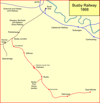
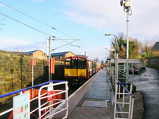
The Busby Railway is a short railway line built on the south side of Glasgow, connecting the small villages of Thornliebank, Giffnock, Clarkston and Busby and later Thorntonhall and East Kilbride with the city. It opened in two stages, in 1866 and 1868, and served industry and encouraged residential development.

<span class="mw-page-title-main">Netherton Goods station</span>

Netherton Goods station or Netherton Depot was a railway public freight facility located between Neilston railway station and Patterton railway station just west of the proposed site of Lyoncross railway station, East Renfrewshire, Scotland. Netherton Goods served the industrial and agricultural requirements for transportation in the vicinity, with the town of Arthurlie not far away, sitting on and near to country lanes to Neilston, Arthurlie and Barrhead. Netherton, Glanderston, Balgraystone and Dyke Farms were located nearby. Netherton Goods was close to Lyoncross Junction between the Lanarkshire and Ayrshire Railway and the Paisley and Barrhead District Railway near Balgray Reservoir.

References

  1. 1 2 Turnock, David (1982). The Historical Geography of Scotland Since 1707 . Cambridge: Cambridge University Press. ISBN   0-521-24453-6.
  2. 1 2 The Glasgow and South Western Railway: A History. Catrine: Stenlake Publishing Limited. 2014. ISBN   978-1-84033-648-1.
  3. 1 2 Thomas, John (1984). A Regional History of the Railways of Great Britain: Volume 6, Scotland, the Lowlands and the Borders. revised by J.S. Paterson. Newton Abbot: David and Charles. ISBN   0-946537-12-7.
  4. Carter, E.F. (1959). An Historical Geography of the Railways of the British Isles. London: Cassell.
  5. 1 2 Ross, David (2014). The Caledonian: Scotland's Imperial Railway: A History. Catrine: Stenlake Publishing Limited. ISBN   978-1840-335842.
  6. Cobb, Col M.H. (2003). The Railways of Great Britain – A Historical Atlas. Shepperton: Ian Allan Publishing Limited. ISBN   07110-3003-0.
  7. Millar, R. (2002) [1902]. Brand, Andrew (ed.). Caledonian Railway: Index of Lines, Connections and Amalgamations etc Chronologically Arranged. Caledonian Railway Association.
  8. Ordnance Survey, Six inch plan, Renfrewshire Sheet XVI.NE, 1915
  9. Renfrewshire Sheet XVI.NE, 1911 plan with revisions of 1938
  10. Wham, Alasdair (2000). The Lost Railway Lines South of Glasgow. Wigtown: G.C. Book Publishers. ISBN   1-8723-5008-9.
  11. "Pressed Steel". Grace's Guide.
  12. "Photograph: Train shed in Dykebar Hospital" . Retrieved 19 September 2007.
  13. "Photograph: Remains of line into Dykebar Hospital" . Retrieved 19 September 2007.
  14. Stansfield, Gordon (1999). Ayrshire & Renfrewshire's Lost Railways. Ochiltree: Stenlake Publishing. ISBN   1-8403-3077-5.
  15. Rowand 2000.
  16. Seller & Stevenson 1980.
  17. "Photographs of railtour in 1951 at bottom of page" . Retrieved 6 October 2007.
  18. "S.L.S. Paisley Area Tour". The Railway Magazine. Vol. 97, no. 607. November 1951. p. 784.
  19. "Train alongside wall at Paisley East goods".
  20. Rowand 2000, p. 154.

Further reading