Paisley West railway station

Last updated

Paisley West
Paisleywestnowhighflats.JPG
The site of Paisley West station in 2007.
General information
Location Paisley, Renfrewshire
Scotland
Coordinates 55°50′21″N4°26′28″W / 55.8392°N 4.4410°W / 55.8392; -4.4410
Platforms2
Other information
StatusDisused
History
Original company Glasgow and South Western Railway
Pre-grouping Glasgow and South Western Railway
Key dates
1 June 1897Opened [1]
14 February 1966Closed [1] [2]

Paisley West railway station was a railway station in Paisley, Renfrewshire, Scotland. The station was originally part of the Paisley Canal Line.

Contents

History

The station opened on 1 June 1897, [1] and closed 14 February 1966. [1]

Preceding station Historical railways Following station
Elderslie
Line and station closed
  Glasgow and South Western Railway
Paisley Canal Line
  Paisley Canal
Line closed; station open
Potterhill
Line and station closed
  Glasgow and South Western Railway
Barrhead Branch
 

See also

Railway stations in Paisley
BSicon CONTg.svg
BSicon CONTg@Gq.svg
BSicon eABZq+r.svg
BSicon STR2+r.svg
BSicon UWu3.svg
BSicon exSTR3+l.svg
BSicon eABZgr+r.svg
Walkinshaw N & S Junctions
Ferguslie
BSicon exSTRc2.svg
BSicon exSTR.svg
BSicon exlvBST@F-.svg
BSicon exSTR3+1u.svg
BSicon STR+4.svg
BSicon HST.svg
Paisley St James
BSicon exSTRc2.svg
BSicon exKRZ3+1o.svg
BSicon exSTRc4.svg
BSicon BHF-L.svg
BSicon BHF-R.svg
Paisley Gilmour Street
BSicon exSTR+1.svg
BSicon exSTRc4.svg
BSicon exSTR2.svg
BSicon exSTRc3.svg
BSicon STR+c2.svg
BSicon STR3.svg
BSicon exCONTg.svg
Wallneuk Junction
BSicon exSTR.svg
BSicon exSTRc1.svg
BSicon exSTR+4.svg
BSicon ABZg+1.svg
BSicon STRc4.svg
BSicon exKHSTaq.svg
BSicon exABZgr.svg
Paisley
Hamilton Street
Greenlaw
Goods
BSicon exSTR.svg
BSicon exSTR.svg
BSicon STR.svg
BSicon exKDST2.svg
BSicon exSTRc3.svg
BSicon exHST.svg
Paisley Abercorn
Stanely
BSicon exBST.svg
BSicon exSTR+l.svg
BSicon exABZgr+r.svg
BSicon eABZgl.svg
BSicon exSTRc1.svg
BSicon exSTRq.svg
BSicon exABZg+r.svg
BSicon exSTR+4.svg
Glenfield
BSicon exBST.svg
BSicon exSTR.svg
BSicon exSTR.svg
BSicon xABZgl+xl.svg
BSicon kSTR2+r.svg
BSicon kSTRc3.svg
BSicon exSTR.svg
Arkleston Junction
(PCL)
Paisley West
BSicon exSTR.svg
BSicon exSTR.svg
BSicon exHST.svg
BSicon exBST.svg
BSicon xkABZg+4.svg
Paisley East
(PCL)
Paisley Canal
BSicon exSTR.svg
BSicon exSTR.svg
BSicon exUWu2.svg
BSicon KHST2xa.svg
BSicon exSTR3.svg
BSicon CONTf.svg
Potterhill
BSicon exSTR.svg
BSicon exHST.svg
BSicon exSTR+1.svg
BSicon lv-HST@F.svg
BSicon eSTR2+4u.svg
BSicon STRc3.svg
Hawkhead
(PCL)
Dykebar
BSicon exSTR2.svg
BSicon exUWu2.svg
BSicon exUWu3.svg
BSicon exABZ23.svg
BSicon exBST3@g.svg
BSicon STRc1.svg
BSicon STRl+4.svg
BSicon lCONTf@Gq.svg
Gleniffer Goods Depot
BSicon exUWu1.svg
BSicon exKDST1.svg
BSicon exABZ+14.svg
BSicon exUWu4.svg
BSicon exSTR2+4.svg
BSicon exSTRc3.svg
Blackbyres
West Junction
(P&BDR)
BSicon exCONTf@F.svg
BSicon exSTRc1.svg
BSicon exSTRl+4.svg
BSicon exlCONTf@Gq.svg

Related Research Articles

<span class="mw-page-title-main">Alexandra Parade railway station</span> Railway station in Glasgow, Scotland

Alexandra Parade railway station is a railway station in Glasgow, Scotland. The station is 1+34 miles (2.8 km) east of Glasgow Queen Street on the Springburn branch of the North Clyde Line. The station is managed by ScotRail.

<span class="mw-page-title-main">Dumbreck railway station</span> Railway station in Glasgow, Scotland

Dumbreck railway station is a railway station in Dumbreck, a district of Glasgow, Scotland. The station is managed by ScotRail and lies on the Paisley Canal Line, 1¾ miles (3 km) west of Glasgow Central, close to the M77 motorway. It is accessed from the Nithsdale Road at the bridge over the railway. Dumbreck railway station is also the closest station for the Bellahouston Park.

<span class="mw-page-title-main">Glengarnock railway station</span> Railway station in North Ayrshire, Scotland

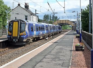
Glengarnock railway station is a railway station in the village of Glengarnock, North Ayrshire, Scotland, serving the towns of Beith and Kilbirnie. The station is managed by ScotRail and is on the Ayrshire Coast Line.

<span class="mw-page-title-main">Corkerhill railway station</span> Railway station in Glasgow, Scotland

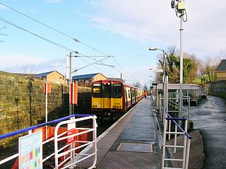
Corkerhill railway station serves the Corkerhill and Mosspark neighbourhoods of Glasgow, Scotland. The station is managed by ScotRail and lies on the Paisley Canal Line, 3¼ miles (5 km) west of Glasgow Central.

<span class="mw-page-title-main">Mosspark railway station</span> Railway station in Glasgow, Scotland

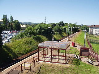
Mosspark railway station serves the Pollok and Cardonald areas of Glasgow, Scotland. The station is on the Paisley Canal Line, 3¾ miles (6 km) west of Glasgow Central and is managed by ScotRail.

<span class="mw-page-title-main">Crookston railway station</span> Railway station in Glasgow, Scotland

Crookston railway station is a railway station in Crookston, a district of Glasgow, Scotland. The station is managed by ScotRail and lies on the Paisley Canal Line which was reopened by British Rail, 412 miles (7 km) west of Glasgow Central.

<span class="mw-page-title-main">Hawkhead railway station</span> Railway station in Renfrewshire, Scotland

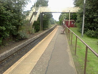
Hawkhead railway station is a railway station in the Seedhill area of Paisley, Renfrewshire, Scotland. The station is managed by ScotRail and lies on the Paisley Canal Line, 6½ miles (10 km) west of Glasgow Central.

<span class="mw-page-title-main">Paisley Canal railway station</span> Railway station in Renfrewshire, Scotland

Paisley Canal railway station is a railway station in Paisley, Renfrewshire, Scotland. The station is managed by ScotRail and lies on the Paisley Canal Line.

Tollcross station was a railway station in the east end of Glasgow, Scotland. It was opened by the Caledonian Railway as Tollcross on 1 February 1897.

Johnstone North railway station was a railway station serving the town of Johnstone, Renfrewshire, Scotland as part of the Dalry and North Johnstone Line on the Glasgow and South Western Railway.

Cumnock railway station was a railway station serving the town of Cumnock, East Ayrshire, Scotland. The station was originally part of the Glasgow, Paisley, Kilmarnock and Ayr Railway. The former site of the station is now a care home. The station is located just off the A70 at Barrhill Road. This is near the Woodroad Viaduct.

Mauchline railway station was a railway station serving the town of Mauchline, East Ayrshire, Scotland. The station was originally part of the Glasgow, Paisley, Kilmarnock and Ayr Railway.

<span class="mw-page-title-main">Occumster railway station</span> Railway station in Highland, Scotland, UK

Occumster was a railway station located between Wick and Lybster, Highland.

Pollokshields railway station was a railway station in Pollokshields, a district of Glasgow, Scotland. The station was originally part of the Glasgow and Paisley Joint Railway. It was opened in 1840 and amalgamated into the neighbouring Shields Road station in 1925.

<span class="mw-page-title-main">Bellahouston railway station</span> Railway station serving the Bellahouston area of Glasgow, Scotland

Bellahouston railway station was a railway station serving the Bellahouston area of Glasgow, Scotland. The station was originally part of the G&SWR Paisley Canal Branch.

Shields railway station was a railway station in Pollokshields, Glasgow, Scotland.

<span class="mw-page-title-main">Glenfield railway station (Scotland)</span>

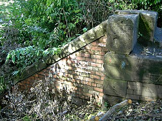
Glenfield was a railway station to the south west of Paisley, Renfrewshire, Scotland.

Oyne railway station is a former railway station serving the small village of Oyne, Aberdeenshire.

<span class="mw-page-title-main">Wolvercote Halt railway station</span> Disused railway station in Oxfordshire, England

Wolvercote Halt was a railway station at Upper Wolvercote near Oxford on the Varsity Line. The London and North Western Railway opened the halt in 1905 and the London, Midland and Scottish Railway closed it in 1926. It was situated on the southern side of First Turn.

<span class="mw-page-title-main">Ayton railway station</span> Disused railway station in Ayton, Scottish Borders

Ayton railway station was a station which served the village of Ayton in the Scottish area of Scottish Borders. It was located on what is now known as the East Coast Main Line. The station was also served by trains on the Berwickshire Railway which diverged from the main line at Reston.

References

Notes

  1. 1 2 3 4 Butt, page 180
  2. Quick, M. E. (2002). Railway passenger stations in England, Scotland and Wales – a chronology. Richmond: Railway and Canal Historical Society. p. 331. OCLC   931112387.

Sources